Google Maps™ driving directions home » Papua New Guinea

Papua New Guinea

Driving Directions Papua New Guinea

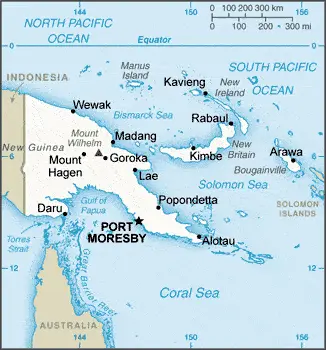
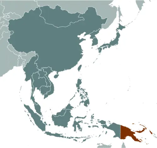
PAPUA NEW GUINEA in the southwest Pacific comprises the eastern half of New Guinea and several archipelagoes and islands, including New Britain, the Bismarck Archipelago, and New Ireland. The other half of New Guinea is Irian Jaya, part of the Indonesian ter­ritory. The main island has a mainly low-lying coast and southern half, but there are spectacular and rugged mountains that form the Highlands from the center to the north.

Read more

Google Maps™ driving directions home » Papua New Guinea

Port Moresby Google maps

Port Moresby is one of the most populated cities in Papua New Guinea, and at the same time, this city is the capital of this country. Located in Oceania, you may find the city easily with the following GPS coordinates: 09.24S latitude / 147.08E longitude. For routing in Port Moresby, please check the free driving directions Port Moresby service below.

Read more

Google Maps™ driving directions home » Papua New Guinea

The most Googled products in each country in Australia and Oceania

Just like earlier, today, in our popular culture, most countries are stereotypically associated with certain products or services. Probably you also would think of Germany regarding beer or Mercedes, carpets of Turkey, electronics of Japan, or pizza of Italy.

Read more

Google Maps™ driving directions home » Papua New Guinea

Papua New Guinea Google Map

This image shows the draft map of Papua New Guinea, Oceania. For more details of the map of Papua New Guinea, please see this page below. This image shows the location of Papua New Guinea, Oceania. For more geographical details of Papua New Guinea, please see this page below. This image shows the flag of Papua New Guinea, Oceania. For more details of the flag of Papua New Guinea, please see this page below.
Borderline map of Papua New Guinea Location map of Papua New Guinea Flag of Papua New Guinea

Papua New Guinea Google map

Google Maps and Detailed Facts of Papua New Guinea (PG). This page lets you explore Papua New Guinea and its border countries (Country Location: Oceania, group of islands including the eastern half of the island of New Guinea between the Coral Sea and the South Pacific Ocean, east of Indonesia) through detailed Satellite imagery – fast and easy as never before Google Maps.

Find comprehensive information about this country’s diversity below: Google maps, geography, economy, science, people, culture, environment, government, and history – All in One Wiki page.

There is also a Street View and free Driving Directions at your service. In Oceania, your Google Satellite Map Sightseeing in Papua New Guinea starts here at Driving Directions and Maps.com.

Read more