
 |
 |
 |
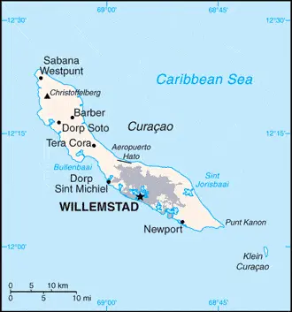
| Borderline map of Curacao | Location map of Curacao | Flag of Curacao |
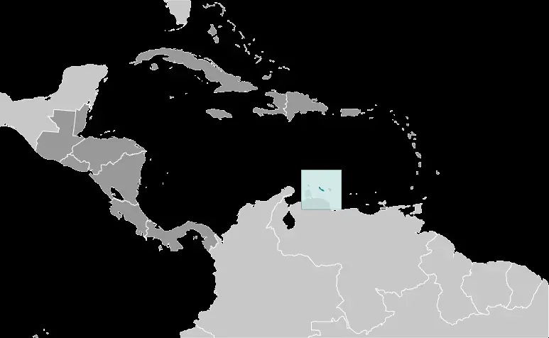
Google Maps and Detailed Facts of Curacao (CC). This page lets you explore Curacao and its border countries (Country Location: the Caribbean, an island in the Caribbean Sea, 30 nm off the coast of Venezuela) through detailed Satellite imagery – fast and easy as never before Google Maps.
Find comprehensive information about this country’s diversity below: Google Maps, geography, economy, science, people, culture, environment, government, and history – All in One Wiki page.
There is also a Street View and free Driving Directions at your service. Your Google Satellite Map Sightseeing in Curacao, in Central America, and the Caribbean, starts here at Driving Directions and Maps.com.
Curacao Google Maps & Satellite Maps
The map below shows Curacao with its cities, towns, highways, main roads, streets, and Street Views. To find a location, use the form below, type any city or place, view a simple map, and click the “show map” button.
The Google Maps above shows Curacao with its location: Central America and the Caribbean (geographic coordinates: 12 10 N, 69 00 W) and the international borders of Curacao; 0 km; furthermore, it’s inland counties boundaries.
Hint: Look at the Street view in Curacao, or Central America, and the Caribbean. All you have to do is drag and pull the little yellow man (named: Pegman) on the Google Maps above the desired location. After that, whenever it is available (more than 50 countries globally), blue stripes will appear to show the photos and details from Google’s regularly updated data image base. In case if you have signed in to your Google account currently, you may have a look at the satellite map of this country/area as well.
The map of Curacao, Central America, and the Caribbean is for informational use only. No representation is made or warrantied given any map or its content by Driving Directions and Maps site. The user assumes all risks of using this Curacao Google Maps and facts/wiki.
About Curacao in detail
Where is Curacao?
In case Curacao is looking on the map under the Coordinates 12 06 N 68 55 W otherwise in Central America, and the Caribbean, in the Caribbean, an island in the Caribbean Sea, 30 nm off the coast of Venezuela.
What is the capital city of Curacao?
The capital city of Curacao is Willemstad.
What is the time in Willemstad?
It is 1 hour ahead of Washington, D.C. during Standard Time; the timezone of Willemstad is UTC-4.
What is the Internet code for Curacao?
The Top Level Domain (TLD) for Curacao is: .cw
What is the size of Curacao?
Curacao’s territory is 444 sq km; land: 444 sq km, water: 0 sq km.
If we want to describe the size of Curacao’s territory is more than twice the size of Washington, DC.
If we would like to walk around and discover Curacao, we can cover 0 km.
What is the water coverage of Curacao?
We have already mentioned what percentage of Curacao is covered by water (see below), including a 364 km coastline.
What is the climate like in Curacao?
Curacao’s climate is tropical marine climate, ameliorated by northeast trade winds, results in mild temperatures: semiarid with an average rainfall of 60 cm/year.
Geographical data of Curacao
Curacao’s elevation; mean elevation: N/A, elevation extremes; lowest point: the Caribbean Sea 0 m, highest point: Mt. Christoffel 372 m.
The specific geographical details of Curacao include generally low, hilly terrain.
Suppose we would like to describe the countries location from a different perspective. In that case, it is safe to say, and easy to read from a map, Curacao is a part of the Windward Islands (southern) group.
Resources and land use of Curacao
The country’s main mined products are calcium phosphates, aloes, sorghum, peanuts, vegetables, tropical fruit. The population partly uses the earlier highlighted land territory and partly left in its natural state: agricultural land: 10%; arable land 10%; permanent crops 0%; permanent pasture 0%; forest: 0%; other: 90% (2011 estimate).
Population data of Curacao
The number of inhabitants of Curacao is 149,035 (July 2016 estimate).
If we examine the proportion of the population distribution, it is safe to say that the largest concentration on the island is Willemstad; smaller settlements near the coast can be found throughout the island, particularly in the northwest.
If we look at the proportion of the urbanized and barely populated areas, these are the figures: urban population: 89.3% of the total population (2015).
Most of the population in Curacao is concentrated in WILLEMSTAD (capital) 145,000 (2014).
Ethnicity in Curacao
According to ethnicity details, the ethnic groups are the Afro-Caribbean majority; Dutch, French, Latin American, East Asian, South Asian, Jewish minorities.
Spoken languages in Curacao
The spoken languages in Curacao are the following: Papiamento (official language) (a creole language that is a mixture of Portuguese, Spanish, Dutch, English, and, to a lesser extent, French, as well as elements of African languages and the language of the Arawak) 81.2%, Dutch (official language) 8%, Spanish 4%, English (official language) 2.9%, other 3.9% (2001 census).
What are the most important religions in Curacao?
During the general census, researchers examine the churches, according to this: Roman Catholic 72.8%, Pentecostal 6.6%, Protestant 3.2%, Adventist 3%, Jehovah’s Witness 2%, Evangelical 1.9%, other 3.8%, none 6%, unspecified 0.6% (2011 estimate).
Further population data of Curacao
The proportion of gender and age tells a lot about the society as follows 0-14 years: 20.17% (male 15,327 / female 14,733) 15-24 years: 14.46% (male 11,239 / female 10,314) 25-54 years: 37.24% (male 27,132 / female 28,370) 55-64 years: 13.49% (male 8,706 / female 11,396) 65 years and over: 14.64% (male 8,993 / female 12,825) (2016 estimate). It also a significant factor in a society the population growth rate, which in the case of Curacao is 0.42% (2016 estimate).
The population growth rate is based on two elements, the birth, and the death rate. In Curacao the birth rate is 13.8 births / 1,000 population (2016 estimate), the death rate 8.3 deaths / 1,000 population (2016 estimate).
In this day and age in developed societies, the first child borns later compared to the previous centuries and decades, so childbearing is extended. In Curacao, the average age of mothers at the first childbirth is N/A.
Although the children’s birth is postponed in the best-case scenario, the parents can still see their kids grow as life expectancy also extended. In the case of Curacao, these figures are. With the introduction of modern medicine, vaccinations, and the proper hygienic conditions, the infant mortality rate is in a steep decline. The infant mortality statistics in Curacao are the following: N/A. Relevant data is the budget of healthcare, which is in the case of this country is N/A.
Economic data of Curacao
Suppose we would like to describe a country, we also have to mention its economy; Most of Curacao’s GDP results from services. Tourism, petroleum refining and bunkering, offshore finance, and transportation and communications are the mainstays of this small island economy, closely tied to the outside world. Curacao has an excellent natural harbor that can accommodate large oil tankers, and the port of Willemstad hosts a free trade zone and a dry dock. Venezuelan state oil company PdVSA, under a contract in effect until 2019, leases the single refinery on theThe government is attempting to diversify its industry and trade and has signed an Association Agreement with the EU to expand business there. In 2013, the government implemented changes to the sales tax and reformed the public pension and health care sys.
GDP is a prominent figure, as all the relevant calculations and statistics are based on it. GDP in Curacao is $5.6 billion (2012 estimate).
Another important indicator is the rate of GDP growth, which in Curacao is 3.6% (2012 estimate), 2% (2011 estimate) 0.1% (2010 estimate).
These statistics affect the world economy; remember, in 2015, the Chinese real GDP growth rate was worse than expected; The world markets fall, and the Chinese stock exchange is temporally suspended.
A further major factor of a country’s economy, the GDP per capita. In Curacao, this is $15,000 (2004 estimate).
In the economy, the Trinity is in common places, such as agriculture, industry, and services.
What are the agricultural products Curacao produces?
The main agricultural products of Curacao are aloe, sorghum, peanuts, vegetables, tropical fruit.
The essential segments are tourism, petroleum refining, petroleum transshipment, light manufacturing, financial, and business services. The crucial and regularly mentioned GDP is based on tourism, petroleum refining, petroleum transshipment, light manufacturing, financial, and business services.
Drinking water source in Curacao
It is essential to mention that – thanks to the infrastructure development– the rate of potable water N/A.
The average number of childbirth in Curacao
In Curacao, the average delivery number is 2.06 children born / woman (2016 estimate).
Population, median age, migration, and citizenship in Curacao
The population’s average age is 36 years; male: 33.3 years, female: 39.8 years (2016 estimate). The age of adulthood varies in every country of the world. In Curacao, it is 18 years of age, universal.
When we are experiencing an unprecedented scale of migration and globalization, it is an important factor in the number of new immigrants. In Curacao is -1.3 migrant(s) / 1,000 population (2016 estimate). It is important to know how to apply for citizenship: see the Netherlands.
Is Curacao a safe destination? Healthcare services and infectious diseases in Curacao
Many of the travelers are looking into the healthcare services and infectious diseases of their destinations. In Curacao, the hospital beds’ density is N/A.
According to the WHO rating regarding contagious diseases in Curacao the note: active local transmission of Zika virus by Aedes species mosquitoes has been identified in this country (as of August 2016); it poses a substantial risk (a large number of cases possible) among US citizens if bitten by an infective mosquito; other less common ways to get Zika are through sex, via blood transfusion, or during pregnancy, in which the pregnant woman passes Zika virus to her fetus (2016).
However, HIV is not curable but maintainable. Let’s do not forget when the disease surfaced; it was a world threatening condition. Unfortunately, in some countries, it is still very high the number of infected patients and fatalities due to the disease.
In Curacao, the number of HIV/AIDS deaths: N/A.
Regarding tourism obesity, not an important issue, but we have to mention health statistics, as it is the plague of the 20th and the 21st century. The rate of obese adults in Curacao is N/A.
What are the natural hazards in Curacao? Is there any?
Curacao’s most known natural risks are Curacao is south of the Caribbean hurricane belt and is rarely threatened.
More interesting facts about Curacao
A few words about the past, as every country and society, are connected to its history; Originally settled by Arawak Indians, Curacao was seized by the Dutch in 1634 and Bonaire’s neighboring island. Once the center of the Caribbean slave trade, Curacao was hard hit economically by abolishing slavery in 1863. Its prosperity (and that of adjacent Aruba) was restored in the early 20th century with the Isla Refineria to service the newly discovered Venezuelan oil fields. In 1954, Curacao and several other Dutch Caribbean possessions were reorganized as the Netherlands Antilles, part of the Kingdom of the Netherlands. In referenda in 2005 and 2009, Curacao’s citizens voted to become a self-governing country within the Kingdom of the Netherlands. The change in status became effective in October 2010 with the dissolution of the Netherlands Antilles.
In every nation’s memory, some cornerstones placed the country on the timeline of history. The date of declaration of Curacao’s independence: none (part of the Kingdom of the Netherlands).
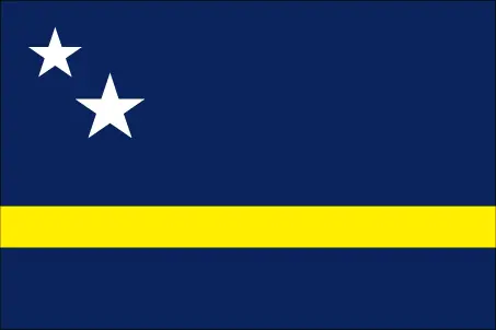
The flag and other symbols of Curacao
The colors, symbols, and animals on the flag usually have a historical background or an important milestone or memory of the nation.
This case is not an exception, either. On a blue field, a horizontal yellow band somewhat below the center divides the flag into proportions of 5:1:2; two five-pointed white stars – the smaller above and to the left of the larger – appear in the canton; the blue of the upper and lower sections symbolizes the sky and sea respectively; yellow represents the sun; the stars indicate Curacao and its uninhabited smaller sister island of Klein Curacao; the five-star points signify the five continents from which Curacao’s people derive.
Apart from the flag, the symbol of national unity is the national anthem. The anthem’s primary purpose is to share the nation’s core values, endeavors, and patriotic feelings.
Curacao’s national symbols: laraha (citrus tree); national colors: blue, yellow, white.
Constitution of Curacao
The existence of the nation is based on the constitution. Some constitutions knew worldwide, like the U.S. Constitution that was accepted on the 17th of September 1787, in Philadelphia, the United States of America’s Constitution.
It is not related to the declaration of independence that was stolen by Nicolas Cage in the movie National Treasure 🙂
What is the legal system of Curacao?
Most of the time, the legal system of a country is the focus of lawyers. It is a common fact that there are two main approaches in the world, “the law in books” and “the law in action.”
In the Anglo-Saxon world, the practice is the “law in action,” while in the rest of the world, the law is based on Roman law, the “law in books.”
Curacao’s legal system is based on the Dutch civil law system with some English common law influence.
It was Aristotle who founded the Theory of 3 separations of powers. In his view, these are the council of public affairs, the magistrates, and the justice system. The age of enlightenment was the time when terminologies have defined the way we still use them. In most democratic countries, the three authorities separated from each other. In dictatorships, the rules usually interweaved in one hand.
We can highlight the following structures unicameral Estates of Curacao or Staten van Curacao (21 seats; members directly elected by proportional representation vote to serve 4-year terms) about the legislative branch of Curacao.
About the unemployment rate, labor force, and poverty line in Curacao
One of the major problems of the 21st-century economy is unemployment. Governments are struggling to maintain a low level of the unemployment rate. Still, as a result of automation, the cheap 3rd world labor, and the outsourcing of workflow, these attempts fail. In Curacao, the labor force is 73,010 (2013). Please bear in mind that the population in Curacao is total: 7.7 deaths / 1,000 live births; male: 8.3 deaths / 1,000 live births, female: 7.1 deaths / 1,000 live births (2016 estimate) – as we already mentioned above.
The rate of unemployment in Curacao is 13% (2013 estimate).
Widely known that the gap between the rich and poor is widening on an enormous scale.
According to the 2017 shocking Oxfam report, the most affluent eight people’s fortune is equal to the wealth of the poorest half of the world’s population.
In Curacao, the households’ income and consumption are compared to the entire population: N/A.
Another widely used indicator is the so-called GINI index, which measures the inequalities of statistical dispersion, but is mainly used for measuring the sharing of income and fortune.
The GINI index was named after its founder Corrado Gini, an Italian economist. Gini index has grades between 0-1, but often it is used on a percentage basis. It is 0 if the examined criteria territorial distribution is equal. It is one of the criteria concentrated on the territory. In Curacao, the GINI index is N/A.
The states usually set up a poverty line, which is more or less, is a subjective measure. It varies by country; its base is often the minimum pension, the incomes of the most deficient 20 percent, the X percent of income per capita Etc.
In Curacao, the number of people living under the poverty line is N/A.
About the budget and central governments debt of Curacao
The available budget mainly defines the state’s economy. The budget of Curacao is; N/A. Taxes and other revenues are 16.6% of GDP (2012 estimate).
The budget deficit (Budget surplus (+) or deficit (-)) is N/A.
The fiscal year in Curacao is N/A.
In the country’s economy, we have to consider the public debt. Public debt is the consolidated sum of the state’s local, federal, and central government debt.
Inflation rate and prime lending rate in Curacao
A few further interesting and relevant economic data are the following; Inflation rate: 2.6% (2013 estimate), 2.8% (2012 estimate), and the commercial bank prime lending rate: N/A.
Export/import partners and data of Curacao
Curacao, with the export of products, industrial tools, and other services, generates revenue. Curacao’s export value is $1.607 billion (2011 estimate), $1.44 billion (2010 estimate). The total revenue of these activities: petroleum products.
The most important export partners of Curacao are N/A.
The most important imported products are crude petroleum, food, manufactures, and the countries from where the import is coming: N/A.
Renewable energies used in Curacao
To suppress the pollution of the environment, renewable energies have to replace the fossil energy. The more the proportion of renewable energies in a country means more effort against pollution. Curacao, the indicator of how much of the country’s produced energy is coming from the hydroelectric source, is N/A.
To indicate how much another renewable energy produced is N/A.
Telecommunication data of Curacao, calling code
To maintain the economy, the development of a reliable and modern telecommunications infrastructure is crucial. We can say the following about Curacao; international: country code – 599.
Transport infrastructure in Curacao
In the 21st century, we often say that the world has become small and there are no distances anymore. With widespread air travel when (sometimes) there are no visa restrictions, it is easy to reach other countries, but if the distance is not too long, we can also use railway or water transportation.
The number of airports in Curacao: N/A, and the number of heliports: N/A.
The total length of the roadways in Curacao: total: 550 km.
The total length of the waterways in Curacao: N/A.
Are you traveling to Curacao?
If you plan to travel by plane to Curacao, try our air ticket comparison site, where you can choose from hundreds of carriers and offers. Our application is scanning the market and shows you the best and the cheapest deals without any extra charge or commission.
Are you looking for a hotel, apartment another kind of accommodation in Curacao, Central America, and the Caribbean? We are here to help you to find your accommodation from budget to luxury. Our search engine is scanning, regularly updating data from hundreds of accommodation websites and more than a million offers. You can quickly and easily find your hotel stay anywhere in the world, without any extra charge or commission.
Facts & data about Curacao
Name of the country: Dutch long form: Land CuracaoDutch short form: CuracaoPapiamentu long form: Pais KorsouPapiamentu short form: Korsou, former: Netherlands Antilles; Curacao and Dependencies, etymology: the most plausible name derivation is that the island was designated Isla de la Curacion (Spanish meaning “Island of the Cure” or “Island of Healing”) or Ilha da Curacao (Portuguese meaning the same) to reflect the locale’s function as a recovery stop for sick crewmen.
| Abbreviation: Curacao | Geographic coordinates: 12 10 N, 69 00 W |
Country Location: Central America and the Caribbean |
| Capital of Curacao: Willemstad | GPS of the Capital: 12 06 N 68 55 W |
Position: Caribbean, an island in the Caribbean Sea, 30 nm off the coast of Venezuela |
| Land area: total: 444 sq km; land: 444 sq km, water: 0 sq km | Terrain: generally low, hilly terrain |
Area comparative: more than twice the size of Washington, DC |
| Population: 149,035 (July 2016 estimate) | Population grow rate: 0.42% (2016 estimate) | Sex ratio: at birth: 1.05 male(s) / female, 0-14 years: 1.04 male(s) / female, 15-24 years: 1.09 male(s) / female, 25-54 years: 0.96 male(s) / female, 55-64 years: 0.76 male(s) / female, 65 years and over: 0.7 male(s) / female, total population: 0.92 male(s) / female (2016 estimate) |
| Exports: $1.607 billion (2011 estimate), $1.44 billion (2010 estimate) | Imports: $1.285 billion (2011 estimate), $1.275 billion (2010 estimate) | Import partners: N/A |
| Urbanization: urban population: 89.3% of the total population (2015) | Major urban area(s): WILLEMSTAD (capital) 145,000 (2014) | Median age: total: 36 years; male: 33.3 years, female: 39.8 years (2016 estimate) |
| Internet users: total: 138,750. Percent of the population: 93.9% (July 2014 estimate) | Telephones (fixed-lines): N/A | Telephones (mobile, cellular): N/A |
| Unemployment rate: 13% (2013 estimate) | Nationality: Curacaoanadjective: Curacaoan; Dutch | National holidays: King’s Day, 27 April 1967 |
| Life expectancy at birth: total population: 78.3 years. Male: 76 years, female: 80.7 years (2016 estimate) | Total fertility rate: 2.06 children born / woman (2016 estimate) | Birthrate: 13.8 births / 1,000 population (2016 estimate) |
| Literacy: N/A | Legal system: based on Dutch civil law system with some English common law influence | Suffrage: 18 years of age, universal |
| Industries: tourism, petroleum refining, petroleum transshipment, light manufacturing, financial and business services | Industrial production growth rate: N/A % | GDP real growth rate: 3.6% (2012 estimate) 2% (2011 estimate) 0.1% (2010 estimate) |
Do you like this Curacao Google Maps & country information page?
Please do us a favor: Share or like this page using the icons at the top of the page. We also do encourage you to visit our Facebook page for more travel and country related information.
Many thanks for visiting and sharing this map & country information site!