
Google Maps and Detailed Facts of Cabo Verde (CV). This page lets you explore Cabo Verde and its border countries (Country Location: Western Africa, group of islands in the North Atlantic Ocean, west of Senegal) through detailed Satellite imagery – fast and easy as never before Google Maps.
Find comprehensive information about this country’s diversity below: Google maps, geography, economy, science, people, culture, environment, government, and history – All in One Wiki page.
There is also a Street View and free Driving Directions at your service. Your Google Satellite Map Sightseeing in Cabo Verde starts at Driving Directions and Maps.com in Africa.
About Cabo Verde in detail
| Borderline map of Cabo Verde | Location map of Cabo Verde | Flag of Cabo Verde |
|---|---|---|
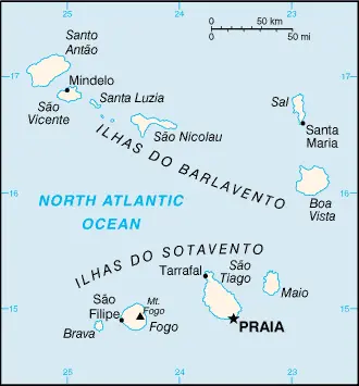 | 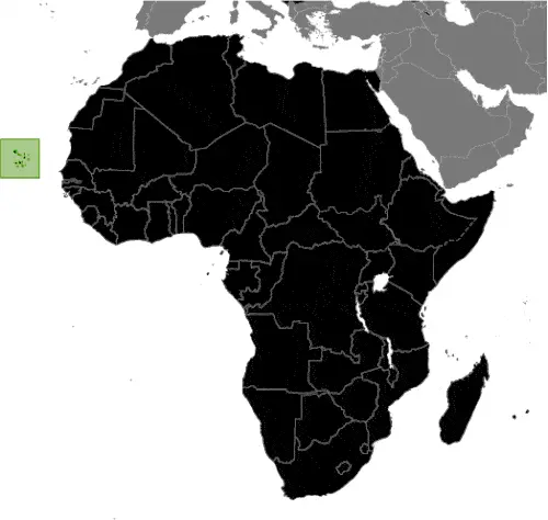 | 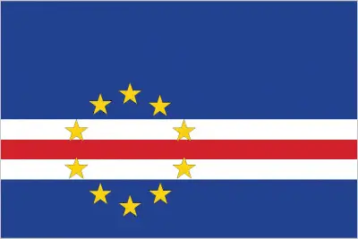 |
Table of contents
- Background
- Overview
- Google Maps
- Climate
- Geography
- Resources and Land Use
- Population Data
- Economic Data
- Drinking Water Source
- Population, Median Age, Migration, and Citizenship
- Average Number of Childbirths
- Is this country a Safe Destination?
- Healthcare and Infectious Diseases
- Natural Hazards
- The Flag and Other Symbols
- Constitution
- Legal System
- About the Unemployment Rate, Labor Force, and Poverty Line
- About the Budget and Central Government Debt
- Inflation Rate and Prime Lending Rate
- Export/Import Partners and Data
- Renewable Energies Used
- Telecommunication Data, Calling Code
- Transport Infrastructure
- More Interesting Facts
Background
Cabo Verde, a group of islands off the northwest coast of Africa, was uninhabited until discovered and colonized by the Portuguese in the 15th century. It became a significant center for the transatlantic slave trade and later played a crucial role as a coaling and resupply stop for whaling and transatlantic shipping. The blending of European and African cultures is evident in Cabo Verde’s unique Crioulo language, music, and textiles. After gaining independence in 1975, Cabo Verde established a one-party system, which transitioned to multi-party elections in 1990. Despite challenges like repeated droughts and heavy emigration, Cabo Verde maintains a stable democratic government and a relatively stable economy.
Overview
Cabo Verde, or Cape Verde, is renowned for its striking blend of African and Portuguese heritage, reflected in its vibrant culture and languages. Situated strategically near major north-south sea routes, the nation has leveraged its geographical advantage to become an important communication and resupply center. The islands’ economy is significantly influenced by their diaspora, which outnumbers the domestic population and is mainly concentrated in Boston and Western Europe.
Official Name: Republic of Cabo Verde
Capital: Praia
Population: 603,901 (2023 estimate)
Total Area: 4,033 sq km
Languages: Portuguese (official), Crioulo
Religions: Roman Catholic 77.3%, Protestant 4.6%, others
Ethnic Groups: Creole 71%, African 28%, European 1%
Government: Parliamentary republic
Currency: Cabo Verdean Escudo (CVE)
Literacy Rate: 90.8%
Cabo Verde Google Maps
Cabo Verde, consisting of ten volcanic islands in the central Atlantic Ocean, offers a picturesque view on Google Maps. The islands’ diverse landscapes, ranging from sandy beaches to rugged mountains, and the unique Creole culture make it an intriguing destination for virtual exploration.
The map below shows Cabo Verde’s cities, towns, highways, main roads, streets, and Street Views. To find a location, use the form below, type any city or place, view a simple map, and click the “show map” button.
The Google map above shows Cabo Verde with its location: Africa (geographic coordinates: 16 00 N, 24 00 W) and the international borders of Cabo Verde; 0 km; furthermore, its inland counties boundaries.
The map of Cabo Verde, Africa, is for informational use only. No representation is made or warrantied given any map or content by the Driving Directions and Maps site. The user assumes all risks of using this Cabo Verde Google map and facts/wiki.
Climate
Cabo Verde, known for its temperate climate characterized by warm, dry summers and limited, unpredictable rainfall, presents unique environmental and agricultural challenges. This climate type is often classified as semi-arid, typical of the Sahel region, which skirts the southern boundary of the Sahara Desert. This geographical position significantly influences Cabo Verde’s climate and environmental conditions.
- Rainfall Patterns: Cabo Verde’s rainfall is sparse and highly variable annually and seasonally. The archipelago receives an average of about 250 mm of rain annually, which can fluctuate widely. Rainfall is mostly concentrated in the short wet season, from August to October, with long dry periods for the rest of the year.
- Temperature Range: The temperatures in Cabo Verde are generally mild, thanks to the moderating influence of the Atlantic Ocean. Average temperatures range from 20°C to 25°C (68°F to 77°F). However, the absence of extreme heat is a notable feature, unlike many other African nations closer to the equator.
- Impact on Agriculture: The climate has a profound impact on agricultural practices. Due to the limited and unpredictable rainfall, agriculture is challenging. The primary crops include beans, corn, and sweet potatoes, typically rain-fed. The reliance on rain-fed agriculture makes the sector particularly vulnerable to climatic variations. As a result, there is a heavy reliance on food imports.
- Water Management: Water scarcity is a significant issue. The country has developed several strategies to manage this, including constructing desalination plants, rainwater harvesting systems, and drip irrigation to conserve water in agriculture.
- Climate Change Impacts: Climate change poses additional risks to Cabo Verde. Predicted changes include increased temperatures, extended dry seasons, and erratic rainfall patterns, which could exacerbate water scarcity and agricultural challenges.
- Biodiversity and Ecosystems: Cabo Verde hosts unique ecosystems and biodiversity despite its dry conditions. The islands are home to several endemic species, particularly birds and reptiles, which have adapted to the arid environment. However, these species are vulnerable to environmental changes.
- Renewable Energy Initiatives: In response to its climatic and environmental conditions, Cabo Verde has been a leader in renewable energy in Africa. The government aims to meet a significant portion of its energy needs through wind and solar power, reducing dependency on imported fossil fuels and mitigating environmental impact.
Cabo Verde’s challenging climatic conditions have led to innovative adaptations in agriculture, water management, and energy use, highlighting the resilience and adaptability of its people and government in the face of environmental challenges.
Geography
The archipelago of Cabo Verde, situated in the central Atlantic Ocean off the coast of West Africa, is renowned for its diverse geographical features, including steep, rugged, and rocky terrain, alongside active volcanic activity. This unique geographical setting significantly contributes to the country’s varied ecosystems and microclimates.
- Topography and Volcanic Activity: The islands’ topography is largely influenced by volcanic activity. The most notable is Mt. Fogo on Fogo Island, the highest point in Cabo Verde at 2,829 meters (9,281 feet). This active stratovolcano last erupted in 2014-2015 and is a key feature in the island’s landscape. The volcanic soil around Mt. Fogo is fertile and supports various forms of agriculture.
- Geographic Diversity and Microclimates: Cabo Verde’s ten main islands and several islets are divided into the Barlavento (windward) islands to the north and the Sotavento (leeward) islands to the south. These islands present a range of landscapes, from sandy beaches to dry, mountainous regions. This diversity creates distinct microclimates across the archipelago, influencing local weather patterns, vegetation, and wildlife.
- Surrounding Countries and Maritime Borders: Geographically, Cabo Verde is an isolated set of islands with no immediate neighboring countries. The closest mainland country is Senegal, located to the northwest, approximately 570 kilometers (354 miles) away. To the northeast lies Mauritania, and further to the east, across the Atlantic, are the Western Sahara and Morocco. To the south, the closest mainland countries are Guinea-Bissau and Guinea.
- Ecosystems and Biodiversity: The varied ecosystems in Cabo Verde range from coastal marine environments to mountainous terrains. These ecosystems support a range of flora and fauna, including several endemic species adapted to the islands’ unique conditions. The marine ecosystem, particularly, is rich in biodiversity, featuring various fish, coral species, and marine mammals.
- Land Use and Agriculture: The rugged terrain and limited water resources have shaped land use in Cabo Verde. Agricultural activities are concentrated in areas with more favorable conditions, particularly in valleys and on the slopes of mountains where soil and moisture are more conducive to farming. However, the amount of arable land is limited due to the steep and rocky nature of much of the terrain.
- Environmental Concerns and Conservation Efforts: The geographic and climatic conditions of Cabo Verde present environmental challenges, including soil erosion, desertification, and limited freshwater resources. Conservation efforts are in place to protect the unique ecosystems, particularly focusing on reforestation, sustainable land management, and preserving marine biodiversity.
Cabo Verde’s geographical features, from its towering volcano to its diverse ecosystems, play a crucial role in shaping the nation’s environmental, economic, and cultural landscape. Despite its small size and isolated location, the archipelago’s rich biodiversity and unique terrain make it a significant ecological and geological entity in the Atlantic region.
Resources and Land Use
Natural resources include salt, basalt rock, limestone, kaolin, fish, clay, and gypsum. Agricultural land constitutes 18.6% of the land use, primarily for cultivating sugar cane, bananas, and vegetables.
Population Data
The population of Cabo Verde is distributed variably across the nine inhabited islands. The eastern islands are drier and less populated, while the more southerly islands, receiving more rainfall, support larger populations. Around half of the population resides on São Tiago Island, Praia’s capital.
Economic Data
The economy of Cabo Verde is largely driven by tourism, bolstered by its proximity to Europe. The COVID-19 pandemic significantly impacted economic growth, highlighting the need for diversification. The country also has a high external debt.
Drinking Water Source
Cabo Verde has a high rate of improved drinking water sources, with 100% coverage in urban areas and 90% in rural areas. However, water scarcity remains a challenge due to the arid climate.
Population, Median Age, Migration, and Citizenship
The median age is 28.3 years. The country has a negative net migration rate, indicative of more people leaving the country. The extensive diaspora significantly contributes to the nation’s economy through remittances.
Average Number of Childbirths
The total fertility rate is 2.11 children born per woman, reflecting a moderate birth rate.
Is this country a Safe Destination?
Cabo Verde is generally considered safe for tourists, with standard travel precautions recommended.
Healthcare and Infectious Diseases
The healthcare system in Cabo Verde is improving, but facilities may be limited, especially in rural areas. Common health concerns include diseases typical of the West African region.
Natural Hazards
The islands are susceptible to prolonged droughts, harmattan winds, and volcanic and seismic activity.
The Flag and Other Symbols
The national flag features horizontal bands of blue, white, and red and a circle of ten yellow stars, symbolizing the nation’s islands. The colors represent the sea, peace, effort, and the people.
Constitution
Cabo Verde’s constitution, effective since September 1992, has undergone several amendments to strengthen its democratic framework.
Legal System
The legal system is based on the civil law system of Portugal, reflecting the country’s colonial past.
About the Unemployment Rate, Labor Force, and Poverty Line
The unemployment rate is relatively high at 15.42%. Poverty remains a significant issue, with a substantial portion of the population living below the poverty line.
About the Budget and Central Government Debt
Cabo Verde’s public debt is a concern, with the government focusing on effectively managing its budget and fiscal policies.
Inflation Rate and Prime Lending Rate
The inflation rate was 1.86% in 2021, indicating moderate economic stability.
Export/Import Partners and Data
Major exports include fish and garments, primarily to Spain and Portugal. The country relies heavily on imports, including refined petroleum and foodstuffs.
Renewable Energies Used
Cabo Verde is increasing its focus on renewable energy, particularly wind and solar, to reduce dependence on imported fuels.
Telecommunication Data, Calling Code
Telecommunications infrastructure is growing, with a focus on mobile and internet connectivity. The country code is +238.
Transport Infrastructure
Transportation infrastructure includes several airports, ports, and a road network, facilitating domestic and international connectivity.
More Interesting Facts
Cabo Verde is celebrated for its rich musical heritage, including genres like Morna and Funaná, and its unique Creole culture. The islands’ strategic location makes them an important hub for maritime and air traffic in the Atlantic.
Did You Know? – Fascinating Facts about Cabo Verde
- A mixture of Cultures: Cabo Verde, once uninhabited, was discovered and colonized by the Portuguese in the 15th century. This resulted in a unique blend of African and Portuguese influences, evident in the country’s culture, language (Crioulo, a Creole based on Portuguese), music, and traditions.
- Archipelago of Volcanic Origin: All the islands in Cabo Verde are of volcanic origin, with Mt. Fogo being the most prominent volcano. It is also one of the few volcanoes in the world with a settlement (Chã das Caldeiras) inside its crater.
- Hub of Transatlantic Slave Trade: In the 16th and 17th centuries, Cabo Verde was a significant center for the transatlantic slave trade due to its strategic location between Africa, Europe, and the Americas.
- Unique Music Style – Morna: Cabo Verde is the birthplace of ‘Morna’, a music genre characterized by melancholic and haunting melodies. Cesária Évora, a world-renowned singer from Cabo Verde, was known as the “Barefoot Diva” for performing without shoes and popularized Morna globally.
- A Leader in Renewable Energy: Cabo Verde aims to source 50% of its energy from renewable sources by 2030. The country is leveraging its geographic position to harness wind and solar energy, setting an example for renewable energy use in Africa.
- Carnival of Mindelo: The city of Mindelo on São Vicente Island hosts one of the most vibrant carnivals in Africa, known for its elaborate costumes and lively parades, reflecting a blend of Brazilian, Portuguese, and African cultures.
- Endemic Species: Despite its dry climate, Cabo Verde is home to unique wildlife, including several endemic bird species, such as the Raso Lark and the Iago Sparrow, found nowhere else in the world.
- Cabo Verdean Diaspora: The Cabo Verdean diaspora is significant, with more Cabo Verdeans living abroad than in the country itself. This has led to a strong cultural exchange, especially with communities in the United States, Portugal, and other parts of Europe.
- Noted for Political Stability: In a region often troubled by political upheaval, Cabo Verde stands out as an example of democracy and political stability in Africa. It regularly receives high rankings in African governance indexes.
- No Natural Resources but a Growing Economy: Despite lacking significant natural resources, Cabo Verde has one of the most stable and growing economies in Africa, which is attributed to its focus on tourism, renewable energy, and maritime services.
These facts highlight Cabo Verde’s rich history, cultural diversity, and efforts in sustainable development, making it a unique and intriguing country on the African continent.
Many thanks for visiting and sharing this map & country information site!