Google Maps™ driving directions home » Kuwait

Asia

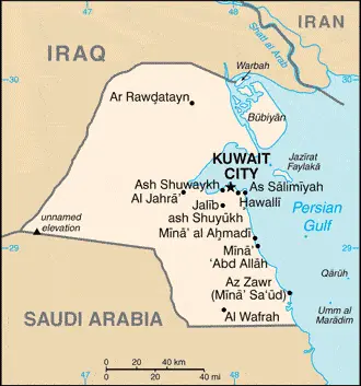
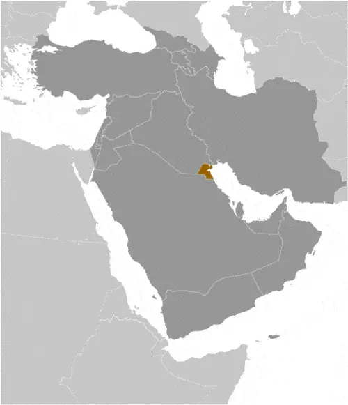
Asia is the world’s largest continent, with a total area of 16,838,365 sq miles (43,608,000 sq km). It comprises 49 separate countries, including 97% of Turkey and 72% of the Russian Federation. Almost 60% of the world’s population lives in Asia.

Area: 16,838,365 sq miles (43,608,000 sq km).
The highest point is Mount Everest, China/Nepal, which is 29,029 ft (8848 m).
The lowest point is the Dead Sea, Israel/Jordan -1388 ft (-423 m) below sea level.
The longest river is the Yangtze, China, which is 3915 miles (6299 km).
The largest lake is the Caspian Sea, Asia/Europe, which is 143,243 sq miles (371,000 sq km).
The largest island is Borneo, Brunie/Indonesia/Malaysia, which is 292,222 sq miles (757,050 sq km).
The highest recorded temperature was Tirat Zevi, Israel, 129°F (54°C).
The lowest recorded temperature was Verkhoyansk, Russian Federation, at 90°F (-68 °C).
The wettest place is Cherrapunji, India, at 450 in (11,430 mm).
The driest place
is in Aden, Yemen, at 1.8 in (46 mm).
Population: Approximately 3,823,390,000 people.
The number of countries: 49.

Read more

Google Maps™ driving directions home » Kuwait

Kuwait

Driving Directions Kuwait

KUWAIT is a tiny Arab Emirate on The Gulf, comprising Kuwait‘s city at the southern entrance of Kuwait Bay, a small desert wedged between Iraq and Saudi Arabia, and nine small offshore islands. Most of the land is barren and consists of a gently undulating plain with no nat­ural watercourses.

Desalination plants use seawater from The Gulf to supply Kuwait’s freshwater needs. The climate is hot and humid in sum­mer and cools to mild in winter with a small rainfall.

Read more

Google Maps™ driving directions home » Kuwait

Kuwait City Google maps

Kuwait City is one of the most populated cities in Kuwait, and at the same time, this city is the capital of this country. Located in Asia, you may find the city easily with the following GPS coordinates: 29.30N latitude / 48.00E longitude. For routing in Kuwait City, please check the free driving directions Kuwait City service below.

Read more

Google Maps™ driving directions home » Kuwait

The most Googled products in each country in Asia

Just like earlier, today, in our popular culture, most countries are stereotypically associated with certain products or services. Probably you also would think of Germany regarding beer or Mercedes, carpets of Turkey, electronics of Japan, or pizza of Italy.

Read more

Google Maps™ driving directions home » Kuwait

Kuwait Google Map

This image shows the draft map of Kuwait, Middle East. For more details of the map of Kuwait, please see this page below. This image shows the location of Kuwait, Middle East. For more geographical details of Kuwait, please see this page below. This image shows the flag of Kuwait, Middle East. For more details of the flag of Kuwait, please see this page below.
Borderline map of Kuwait Location map of Kuwait Flag of Kuwait

Kuwait Google map

Google Maps and Detailed Facts of Kuwait (KW). This page lets you explore Kuwait and its border countries (Country Location: the Middle East, bordering the Persian Gulf, between Iraq and Saudi Arabia) through detailed Satellite imagery – fast and easy as never before Google Maps.

Find comprehensive information about this country’s diversity below: Google maps, geography, economy, science, people, culture, environment, government, and history – All in One Wiki page.

There is also a Street View and free Driving Directions at your service. Your Google Satellite Map Sightseeing in Kuwait, in the Middle East, starts here at Driving Directions and Maps.com.

Read more