
 |
 |
 |
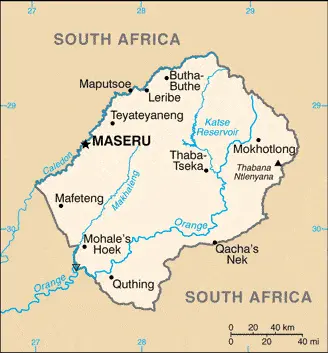
| Borderline map of Lesotho | Location map of Lesotho | Flag of Lesotho |
Google Maps and Detailed Facts of Lesotho (LS). This page lets you explore Lesotho and its border countries (Country Location: Southern Africa, an enclave of South Africa) through detailed Satellite imagery – fast and easy as never before Google Maps.
Find comprehensive information about this country’s diversity below: Google maps, geography, economy, science, people, culture, environment, government, and history – All in One Wiki page.
There is also a Street View and free Driving Directions at your service. Your Google Satellite Map Sightseeing in Lesotho, in Africa, starts here at Driving Directions and Maps.com.
Lesotho Google Maps & Satellite Maps
The map below shows Lesotho with its cities, towns, highways, main roads, streets, and Street Views. To find a location, use the form below, type any city or place, view a simple map, and click the “show map” button.
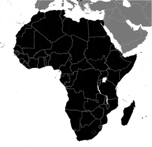
The Google map above shows Lesotho with its location: Africa (geographic coordinates: 29 30 S, 28 30 E) and the international borders of Lesotho; total: 1,106 km. Border countries (total: 1): South Africa 1,106 km; furthermore, it’s inland counties boundaries.
Hint: Look at the Street view in Lesotho, or Africa. All you have to do is drag and pull the little yellow man (named: Pegman) on the Google map above the desired location. After that, whenever it is available (more than 50 countries globally), blue stripes will appear to show the photos and details from Google’s regularly updated data image base. In case if you have signed in to your Google account currently, you may have a look at the satellite map of this country/area as well.
The map of Lesotho, Africa, is for informational use only. No representation is made or warrantied given any map or its content by Driving Directions and Maps site. The user assumes all risks of using this Lesotho Google map and facts/wiki.
About Lesotho in detail
Where is Lesotho?
Lesotho, in case, if you are looking on the map under the Coordinates 29 19 S 27 29 E otherwise in Africa, in Southern Africa, an enclave of South Africa.
What is the capital city of Lesotho?
The capital city of Lesotho is Maseru.
What is the time in Maseru?
It is 7 hours ahead of Washington, D.C. during Standard Time; the timezone of Maseru is UTC+2.
What is the Internet code for Lesotho?
The Top Level Domain (TLD) for Lesotho is: .ls
What is the size of Lesotho?
The territory of Lesotho is total: 30,355 sq km; land: 30,355 sq km, water: 0 sq km.
If we want to describe the size of the territory of Lesotho is somewhat smaller than Maryland.
If we would like to walk around and discover Lesotho, we can cover a total distance: 1,106 km.
What is the water coverage of Lesotho?
We have already mentioned what percentage of Lesotho is covered by water (see below), and this includes 0 km (landlocked country) coastline.
What is the climate like in Lesotho?
The climate of Lesotho is temperate: cool to cold, dry winters: hot, wet summers.
Geographical data of Lesotho
Lesotho’s elevation; mean elevation: 2,161 m, elevation extremes; lowest point: junction of the Orange and Makhaleng Rivers 1,400 m, highest point: Thabana Ntlenyana 3,482 m.
The specific geographical details of Lesotho include mostly highland with plateaus, hills, and mountains.
Suppose we would like to describe the countries location from a different perspective. In that case, it is safe to say, and easy to read from a map, Lesotho is landlocked, surrounded by South Africa; mountainous, more than 80% of the country is 1,800 m above sea level.
Resources and land use of Lesotho
The country’s main mined products are water, agricultural and grazing land, diamonds, sand, clay, building stone. The population partly uses the earlier highlighted land territory and partly left in its natural state: agricultural land: 76.1%; arable land 10.1%; permanent crops 0.1%; permanent pasture 65.9%; forest: 1.5%; other: 22.4% (2011 estimate).
Population data of Lesotho
The number of inhabitants of Lesotho is 1,953,070 (July 2016 estimate).
If we examine the proportion of the population distribution, it is safe to say that N/A.
If we look at the proportion of the urbanized and barely populated areas, these are the figures: urban population: 27.3% of the total population (2015).
Most of the population in Lesotho is concentrated in MASERU (capital) 267,000 (2014).
Ethnicity in Lesotho
According to ethnicity details, the ethnic groups are Sotho 99.7%, Europeans, Asians, and other 0.3%.
Spoken languages in Lesotho
The spoken languages in Lesotho are the following: Sesotho (official language) (southern Sotho), English (official language), Zulu, Xhosa.
What are the most important religions in Lesotho?
During the general census, researchers examine the churches, according to this: Christian 80%, indigenous beliefs 20%.
Further population data of Lesotho
The proportion of gender and age tells a lot about the society as follows 0-14 years: 32.4% (male 317,933 / female 314,849) 15-24 years: 19.56% (male 181,907 / female 200,113) 25-54 years: 37.58% (male 358,643 / female 375,313) 55-64 years: 5% (male 52,016 / female 45,549) 65 years and over: 5.47% (male 54,466 / female 52,281) (2016 estimate). It also a significant factor in a society the population growth rate, which in the case of Lesotho is 0.3% (2016 estimate).
The population growth rate is based on two elements, the birth, and the death rate. In Lesotho the birth rate is 25.1 births / 1,000 population (2016 estimate), the death rate 14.9 deaths / 1,000 population (2016 estimate).
In this day and age in developed societies, the first child borns later compared to the previous centuries and decades, so childbearing is extended. In Lesotho, the average age of mothers at the first childbirth is N/A.
Although the children’s birth is postponed in the best-case scenario, the parents can still see their kids grow as life expectancy also extended. In the case of Lesotho, these figures are. With the introduction of modern medicine, vaccinations, and the proper hygienic conditions, the infant mortality rate is in a steep decline. The infant mortality statistics in Lesotho are the following: N/A. Relevant data is the budget of healthcare, which is in the case of this country is 10.6% of GDP (2014).
Economic data of Lesotho
Suppose we would like to describe a country. We also have to mention its economy; Small, mountainous, and completely landlocked by South Africa, Lesotho depends on a narrow economic base of textile manufacturing, agriculture, remittances, and regional customs revenue. About three-fourths of the people live in rural areas. Lesotho relies on South Africa for much of its economic activity; Lesotho imports 90% of the goods it consumes from South Africa, including most agricultural inputs. Households depend heavily on remittances from family members working in South Africa. The government maintains a large presence in the economy – government consumption accounted for 27% of GDP in 2016, and the government remains Lesotho’s largest employer. Access to credit remains a problem for the private sector.
GDP is a prominent figure, as all the relevant calculations and statistics are based on it. GDP in Lesotho is $1.806 billion (2015 estimate).
Another important indicator is the rate of GDP growth, which in Lesotho is 2.4% (2016 estimate), 2.8% (2015 estimate) 3.4% (2014 estimate).
These statistics affect the world economy; remember, in 2015, the Chinese real GDP growth rate was worse than expected; The world markets fall, and the Chinese stock exchange was temporarily suspended.
A further major factor of a country’s economy, the GDP per capita. In Lesotho this is $3,100 (2016 estimate) $3,000 (2015 estimate) $3,000 (2014 estimate).
In the economy, the Trinity is in common places, such as agriculture, industry, and services.
What are the agricultural products Lesotho produces?
The main agricultural products of Lesotho are corn, wheat, pulses, sorghum, barley, livestock.
The essential segments are food, beverages, textiles, apparel assembly, handicrafts, construction, and tourism. The crucial and regularly mentioned GDP is based on food, drinks, textiles, apparel assembly, handicrafts, construction, tourism.
Drinking water source in Lesotho
It is essential to mention that – thanks to the development of the infrastructure -, the rate of potable water improved: urban: 94.6% of the population, rural: 77% of the population, total: 81.8% of the population. Unimproved: urban: 5.4% of the people, rural: 23% of the people, 18.2% of the population (2015 estimate).
The average number of childbirth in Lesotho
In Lesotho, the average delivery number is 2.68 children born / woman (2016 estimate).
Population, median age, migration, and citizenship in Lesotho
The population’s average age is 24 years; male: 24 years, female: 24 years (2016 estimate). The age of adulthood varies in every country of the world in Lesotho; it is 18 years of age, universal.
When we are experiencing an unprecedented scale of migration and globalization, it is an important factor in the number of new immigrants. In Lesotho is -7.1 migrant(s) / 1,000 population (2016 estimate). It is important to know how to apply for citizenship: citizenship by birth: yes. Citizenship by descent: yes. Dual citizenship recognized: no—residency requirement for naturalization: 5 years.
Is Lesotho a safe destination? Healthcare services and infectious diseases in Lesotho
Many of the travelers are looking into the healthcare services and infectious diseases of their destinations. In Lesotho, the hospital beds’ density is 1.3 beds / 1,000 population (2006).
According to the WHO rating regarding contagious diseases in Lesotho: N/A.
However, HIV is not curable but maintainable. Let’s do not forget when the disease surfaced; it was a world threatening condition. Unfortunately, in some countries, it is still very high the number of infected patients and fatalities due to the disease.
In Lesotho, the number of HIV/AIDS deaths: N/A.
Regarding tourism obesity, not an important issue, but we have to mention health statistics, as it is the plague of the 20th and the 21st century. The rate of obese adults in Lesotho is 11.9% (2014).
What are the natural hazards in Lesotho? Is there any?
The most known natural risk in Lesotho is periodic droughts.
More interesting facts about Lesotho
A few words about the past, as every country and society, are connected to its history; Basutoland was renamed Lesotho’s Kingdom upon independence from the UK in 1966. The Basuto National Party ruled the country during its first two decades. King MOSHOESHOE was exiled in 1990 but returned to Lesotho in 1992 and was reinstated in 1995 and subsequently succeeded by his son, King LETSIE III, in 1996. Constitutional government was restored in 1993 after seven years of military rule. In 1998, violent protests and a military mutiny following a contentious election prompted a brief but bloody intervention by South African and Batswana military forces under the Southern African Development Community’s aegis. Subsequent constitutional reforms restored relative political stability. Peaceful parliamentary elections were held in 2002, but the National Assembly elections of February 2007 were hotly contested, and aggrieved parties disputed how the electoral law was applied to award proportional seats in the Assembly.
In May 2012, competitive elections involving 18 parties saw Prime Minister Motsoahae Thomas THABANE form a coalition government – the first in the country’s history – that ousted the 14-year incumbent, Pakalitha MOSISILI, who peacefully transferred power the following month. MOSISILI returned to power in snap elections in February 2015 after the collapse of THABANE’s coalition government and an alleged attempted military coup.
In every nation’s memory, some cornerstones placed the country on the timeline of history. The date of declaration of independence of Lesotho: 4 October 1966 (from the UK).
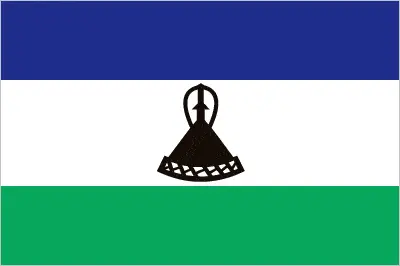
The flag and other symbols of Lesotho
The colors, symbols, and animals on the flag usually have a historical background or an important milestone or memory of the nation.
This case is not an exception either; three horizontal stripes of blue (top), white, and green in the proportions of 3:4:3; the colors represent rain, peace, and prosperity respectively; centered in the white stripe is a black Basotho hat representing the indigenous people; the flag was unfurled in October 2006 to celebrate 40 years of independence.
Apart from the flag, the symbol of national unity is the national anthem. The anthem’s primary purpose is to share the nation’s core values, endeavors, and patriotic feelings.
National symbols of Lesotho: mokorotio (Basotho hat); national colors: blue, white, green, black.
Constitution of Lesotho
The existence of the nation is based on the constitution. Some constitutions knew worldwide, like the U.S. Constitution that was accepted on the 17th of September 1787, in Philadelphia, the United States of America’s Constitution.
It is not related to the declaration of independence that was stolen by Nicolas Cage in the movie National Treasure 🙂
What is the legal system of Lesotho?
Most of the time, the legal system of a country is the focus of lawyers. It is a common fact that there are two main approaches in the world, “the law in books” and “the law in action.”
In the Anglo-Saxon world, the practice is the “law in action,” while in the rest of the world, the law is based on Roman law, the “law in books.”
Lesotho’s legal system is a mixed legal system of English common law and Roman-Dutch law; judicial review of legislative acts in the High Court and Court of Appeal.
It was Aristotle who founded the Theory of 3 separations of powers. In his view, these are the council of public affairs, the magistrates, and the justice system. The age of enlightenment was the time when terminologies have defined the way we still use them. In most democratic countries, the three authorities separated from each other. In dictatorships, the rules usually interweaved in one hand.
About the legislative branch of Lesotho, we can highlight the following structures bicameral Parliament consists of the Senate (33 seats; 22 principal chiefs and 11 other senators nominated by the king with the advice of the Council of State, a 13-member body of crucial government and non-government officials; members serve 5-year terms) and the National Assembly (120 seats; 80 members directly elected in single-seat constituencies by simple majority vote and 40 directly elected in single-seat constituencies by proportional representation vote; members serve 5-year terms).
About the unemployment rate, labor force, and poverty line in Lesotho
One of the major problems of the 21st-century economy is unemployment. Governments are struggling to maintain a low level of the unemployment rate. Still, as a result of automation, the cheap 3rd world labor, and the outsourcing of workflow, these attempts fail. In Lesotho, the labor force is 919,900 (2016 estimate). Please bear in mind that the population in Lesotho is total: 47.6 deaths / 1,000 live births; male: 51.2 deaths / 1,000 live births, female: 43.8 deaths / 1,000 live births (2016 estimate) – as we already mentioned above.
The rate of unemployment in Lesotho is 28.1% (2014 estimate).
Widely known that the gap between the rich and poor is widening on an enormous scale.
According to the 2017 shocking Oxfam report, the most affluent eight people’s fortune is equal to the wealth of the poorest half of the world’s population.
In Lesotho, the households’ income and consumption compared to the entire population: lowest 10%: 1% highest 10%: 39.4% (2003).
Another widely used indicator is the so-called GINI index, which measures the inequalities of statistical dispersion, but is mainly used for measuring the sharing of income and fortune.
The GINI index was named after its founder Corrado Gini, an Italian economist. Gini index has grades between 0-1, but often it is used on a percentage basis. It is 0 if the examined criteria territorial distribution is equal. It is one of the criteria concentrated on the territory. In Lesotho, the GINI index is .63,2 (1995).
The states usually set up a poverty line, which is more or less, is a subjective measure. It varies by country; its base is often the minimum pension, the incomes of the most deficient 20 percent, the X percent of income per capita Etc.
In Lesotho, the poverty line people are the lowest 10%: 1% highest 10%: 39.4% (2003).
About the budget and central governments debt of Lesotho
The available budget mainly defines the state’s economy. Lesotho’s budget is; revenues: $835.9 million, expenditures: $978.3 million (2016 estimate). Taxes and other revenues are 46.3% of GDP (2016 estimate).
The budget deficit (Budget surplus (+) or deficit (-)) is N/A.
The fiscal year in Lesotho is 1 April – 31 March.
In the country’s economy, we have to consider the public debt. Public debt is the consolidated sum of the state’s local, federal, and central government debt.
Inflation rate and prime lending rate in Lesotho
A few further interesting and relevant economic data are the following; Inflation rate: 8.3% (2016 estimate), 3.2% (2015 estimate), and the rate of the Commercial bank prime lending rate: 12.3% (31 December 2016 estimate).
Export/import partners and data of Lesotho
Lesotho, with the export of products, industrial tools, and other services, generates revenue. Lesotho’s export value is $851.6 million (2016 estimate), $844.1 million (2015 estimate). These activities’ total revenue: manufactures (clothing, footwear), wool and mohair, food and live animals, electricity, water, diamonds.
The most important export partners of Lesotho are N/A.
The most important imported products are food, building materials, vehicles, machinery, medicines, petroleum products, and the countries from where the import is coming: N/A.
Renewable energies used in Lesotho
To suppress the pollution of the environment, renewable energies have to replace the fossil energy. The more the proportion of renewable energies in a country means more effort against pollution. Lesotho, the indicator of how much of the country’s produced energy is coming from the hydroelectric source, is 100% of total installed capacity (2012 estimate).
To indicate how much another renewable energy produced is 0% of total installed capacity (2012 estimate).
Telecommunication data of Lesotho, calling code
To maintain the economy, the development of a reliable and modern telecommunications infrastructure is crucial. We can say the following about Lesotho: a modest number of landlines, a small microwave radio relay system, and a small radiotelephone communication system; mobile-cellular telephone system is expanding. Domestic: privatized in 2001, Telecom Lesotho was tasked with providing an additional 50,000 fixed-line connections within five years, a target not met; mobile-cellular service dominates the market and is expanding with a subscribership now over 110 per 100 persons. International: country code – 266; satellite earth station – 1 Intelsat (Atlantic Ocean) (2015).
Transport infrastructure in Lesotho
In the 21st century, we often say that the world has become small and there are no distances anymore. With widespread air travel when (sometimes) there are no visa restrictions, it is easy to reach other countries, but if the distance is not too long, we can also use railway or water transportation.
The number of airports in Lesotho: 24 (2013), and the number of heliports: N/A.
The total length of the roadways in Lesotho: 5,940 km, paved: 1,069 km, unpaved: 4,871 km (2011).
The total length of the waterways in Lesotho: N/A.
Are you traveling to Lesotho?
If you plan to travel by plane to Lesotho, try our air ticket comparison site, where you can choose from hundreds of carriers and offers. Our application is scanning the market and shows you the best and the cheapest deals without any extra charge or commission.
Are you looking for a hotel, apartment another kind of accommodation in Lesotho, Africa? We are here to help you to find your accommodation from budget to luxury. Our search engine is scanning, regularly updating data from hundreds of accommodation websites and more than a million offers. You can quickly and easily find your hotel stay anywhere in the world, without any extra charge or commission.
Facts & data about Lesotho
Name of the country: conventional long way: the Kingdom of Lesotho, traditional short form: Lesotho, local long form: the Kingdom of Lesotho, local short state: Lesotho, former: Basutoland, etymology: the name translates as “Land of the Sesotho speakers.”
| Abbreviation: Lesotho | Geographic coordinates: 29 30 S, 28 30 E |
Country Location: Africa |
| Capital of Lesotho: Maseru | GPS of the Capital: 29 19 S 27 29 E |
Position: Southern Africa, an enclave of South Africa |
| Land area: total: 30,355 sq km; land: 30,355 sq km, water: 0 sq km | Terrain: mostly highland with plateaus, hills, and mountains |
Area comparative: somewhat smaller than Maryland |
| Population: 1,953,070 (July 2016 estimate) | Population grow rate: 0.3% (2016 estimate) | Sex ratio: at birth: 1.03 male(s) / female, 0-14 years: 1.01 male(s) / female, 15-24 years: 0.91 male(s) / female, 25-54 years: 0.96 male(s) / female, 55-64 years: 1.14 male(s) / female, 65 years and over: 1.03 male(s) / female, total population: 0.98 male(s) / female (2016 estimate) |
| Exports: $851.6 million (2016 estimate), $844.1 million (2015 estimate) | Imports: $1.688 billion (2016 estimate), $1.737 billion (2015 estimate) | Import partners: N/A |
| Urbanization: urban population: 27.3% of the total population (2015) | Major urban area(s): MASERU (capital) 267,000 (2014) | Median age: total: 24 years; male: 24 years, female: 24 years (2016 estimate) |
| Internet users: total: 313,000. Percent of the population: 16.1% (July 2015 estimate) | Telephones (fixed-lines): total subscriptions: 45,364. Subscriptions per 100 inhabitants: 2 (July 2015 estimate) | Telephones (mobile, cellular): total: 2.237 million. Subscriptions per 100 inhabitants: 115 (July 2015 estimate) |
| Unemployment rate: 28.1% (2014 estimate) | Nationality: Mosotho (singular), Basotho (plural) adjective: Basotho | National holidays: Independence Day, 4 October (1966) |
| Life expectancy at birth: total population: 53 years. Male: 52.9 years, female: 53.1 years (2016 estimate) | Total fertility rate: 2.68 children born / woman (2016 estimate) | Birthrate: 25.1 births / 1,000 population (2016 estimate) |
| Literacy: age 15 and over can read and write. Total population: 79.4%; male: 70.1%, female: 88.3% (2015 estimate) | Legal system: mixed legal system of English common law and Roman-Dutch law; judicial review of legislative acts in High Court and Court of Appeal | Suffrage: 18 years of age, universal |
| Industries: food, beverages, textiles, apparel assembly, handicrafts, construction, tourism | Industrial production growth rate: 0.7% (2016 estimate) | GDP real growth rate: 2.4% (2016 estimate) 2.8% (2015 estimate) 3.4% (2014 estimate) |
Do you like this Lesotho Google maps™ & country information page?
Please do us a favor: Share or like this page using the icons at the top of the page. We also do encourage you to visit our Facebook page for more travel and country related information.
Many thanks for visiting and sharing this map & country information site!