
Driving Directions and Google Map of New Zealand — Roads, Routes & Navigation Guide
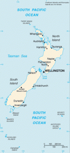
New Zealand — Aotearoa (“Land of the Long White Cloud” in Māori) — is an island nation in the southwestern Pacific Ocean, comprising two main islands and numerous smaller ones. The North Island (Te Ika-a-Māui) and South Island (Te Waipounamu), separated by the Cook Strait, together cover 268,021 km² of extraordinarily diverse landscape: volcanic plateaus, geothermal fields, subtropical rainforests, alpine peaks (Southern Alps, reaching 3,724 m at Aoraki/Mount Cook), fjords, golden beaches, and rolling farmland. New Zealand is consistently ranked among the world’s most scenic countries to drive through, and the car is by far the most practical and popular way to explore both islands.
New Zealand drives on the left-hand side of the road with right-hand drive vehicles — a legacy of British colonial heritage. Speed limits are in kilometres per hour. The road network is managed by Waka Kotahi NZ Transport Agency for state highways and by regional and territorial authorities for local roads. New Zealand uses State Highway (SH) numbering for its primary national road network. Outside major cities, New Zealand’s roads are predominantly single-carriageway with a default open road speed limit of 100 km/h — higher than the rural standard in most European countries. New Zealand has no national vignette; electronic tolls apply to a small number of specific roads.
New Zealand’s drink-drive limit is 0.05% BAC for drivers aged 20 and over; drivers under 20 face a strict zero alcohol limit (0.00% BAC). The currency is the New Zealand Dollar (NZD / NZ$). The emergency number is 111 — not 112 as used in Europe. Use the route planner on our homepage to plan your New Zealand road trip.
The New Zealand Road Network
New Zealand’s road network is managed by Waka Kotahi NZ Transport Agency for approximately 11,000 km of state highways, and by 67 territorial local authorities for the remaining ~90,000 km of local roads. The total network is approximately 101,000 km. New Zealand’s state highway network uses SH prefix numbering (State Highway 1, State Highway 2, etc.). Motorway-standard roads (grade-separated with controlled access) exist only in the main urban areas — Auckland, Wellington, Hamilton, Tauranga, and Christchurch — and total only several hundred kilometres. The overwhelming majority of New Zealand’s state highways are single-carriageway rural roads.
New Zealand’s challenging terrain — particularly the Southern Alps on the South Island and the volcanic plateau and ranges of the central North Island — means that many state highways are narrow, winding, and sometimes steep. Single-lane bridges are a common and distinctive feature of New Zealand rural roads, particularly on the South Island and in rural parts of the North Island. The rule at a single-lane bridge is clear: one direction has priority (indicated by a give-way sign and blue arrow indicating who must yield); if you face a red arrow or give-way sign, you must stop and wait for approaching traffic to clear the bridge before proceeding.
Primary State Highways:
- SH1 — the main north–south spine of both islands (~2,100 km total): State Highway 1 is the primary national route, running from Cape Reinga at the northernmost tip of the North Island to Bluff at the southern tip of the South Island — with a Cook Strait ferry gap between Wellington and Picton. On the North Island, SH1 runs from Auckland south through Hamilton, Taupo (on the shore of Lake Taupo — New Zealand’s largest lake), Waiouru (central plateau), Palmerston North, and into Wellington. On the South Island, SH1 runs from Picton south along the east coast through Kaikōura (famous for whale watching), Christchurch, Timaru, and Dunedin to Invercargill and the Bluff. Journey time Auckland–Wellington approximately 8–9 hours (650 km) including the Taupo detour; Picton–Christchurch approximately 4 hours (340 km); Christchurch–Queenstown via SH1 and SH8 approximately 5 hours (490 km).
- SH2 — East Coast North Island alternative (~570 km): The eastern alternative to SH1 on the North Island, running from Auckland through the Coromandel Peninsula gateway, Hamilton area, Tauranga (Bay of Plenty), Whakatāne, Gisborne, Napier (Hawke’s Bay wine region), and Masterton into Wellington. The SH2 Hawke’s Bay section passes through the wine country and Art Deco architecture of Napier and Hastings.
- SH6 — Nelson to Queenstown via the West Coast (~800 km): One of New Zealand’s most scenic long-distance routes, connecting Nelson (top of the South Island) with Queenstown via the Nelson Lakes, the West Coast (Westland), and Haast. The West Coast section passes through dense temperate rainforest, the Franz Josef and Fox glaciers (descending to near sea level — a rare phenomenon), and the dramatic Haast Pass. The SH6 West Coast route is mostly single-carriageway through remote terrain; fuel stops must be planned carefully. Journey time Nelson–Queenstown via SH6 approximately 8 hours.
- SH73 — Arthur’s Pass (Christchurch to Greymouth, ~250 km): The central South Island crossing via Arthur’s Pass (920 m) through the Southern Alps. One of New Zealand’s most dramatic road journeys, climbing from the Canterbury plains through beech forest and subalpine vegetation to the main divide and descending to the West Coast. The road passes through Arthur’s Pass village and national park. Subject to snow and ice closures in winter; chains may be required.
- SH94 — Milford Road (Te Anau to Milford Sound, ~120 km): The access road to Milford Sound / Piopiotahi in Fiordland National Park — one of the world’s most celebrated road journeys. The road passes through the glaciated Eglinton Valley, the Mirror Lakes, the Avenue of the Disappearing Mountain, and through the Homer Tunnel (1,270 m; steep, one-lane, no traffic lights — priority determined by staff on site) to the fiord. The road ends at Milford Sound; there is no through route. The road is subject to avalanche closures in winter; check conditions before travelling. Journey time Te Anau–Milford Sound approximately 2 hours.
- SH8 — Inland South Island via Tekapo and Queenstown (~500 km from Christchurch): The inland route from Christchurch to Queenstown via the Mackenzie Basin — home to the stunning turquoise Lake Tekapo (one of the world’s great stargazing locations — International Dark Sky Reserve) and Lake Pukaki (with Aoraki/Mount Cook reflected in its extraordinary blue waters). The SH8 passes through Twizel and connects to the Aoraki/Mount Cook National Park road. One of New Zealand’s most rewarding long drives.
- SH1 — Kaikōura Coast (Picton to Christchurch): The coastal route between Picton and Christchurch hugs the dramatic Kaikōura coast — limestone cliffs rising straight from the Pacific, with resident sperm whales, dusky dolphins, and the Kaikōura mountain range as backdrop. The road was substantially damaged by a 2016 earthquake and was rebuilt with significant upgrades. Journey time Picton–Kaikōura approximately 2 hours; Kaikōura–Christchurch approximately 2.5 hours.
Driving Rules and Legal Requirements
Drive on the LEFT: New Zealand drives on the left-hand side of the road with right-hand drive vehicles. For visitors from countries that drive on the right (including all of continental Europe, the USA, and Canada), this requires deliberate adjustment. The most dangerous moments for right-side drivers in New Zealand are immediately after getting into the car, leaving a parking space, exiting petrol stations, and turning at intersections — particularly left turns, where there is a strong instinct to swing wide into the wrong lane. A useful reminder technique is to position the driver as close to the centre line as possible. Give yourself extra time and mental attention for the first several days of driving on the left.
New Zealand’s drink-drive limits are 0.05% BAC for drivers aged 20 and over, and a strict zero tolerance (0.00% BAC) for drivers under 20. New Zealand Police conduct breath testing checkpoints frequently, particularly on holiday weekends (Easter, Labour Weekend, Christmas–New Year) and on summer evenings. Penalties for drink-driving are serious and include demerit points, fines, and disqualification; repeat offenders face vehicle confiscation. Drug-impaired driving is equally prohibited and Police use oral fluid drug-testing.
Headlights: Headlights are required from dusk to dawn and in conditions of poor visibility. Daytime running lights are not legally required in New Zealand during daylight hours in normal visibility conditions — a notable difference from Scandinavian countries. However, using headlights in rain and low-visibility conditions is strongly recommended and legally required in reduced visibility.
Speed cameras: New Zealand operates fixed speed cameras, mobile speed camera units (operated by NZ Police in unmarked vehicles), and intersection red-light cameras. Fixed cameras are located at known high-risk sites; mobile cameras are not sign-posted and can be deployed anywhere. Speed camera fines are fixed-rate (not income-proportional); the fine and demerit point schedule escalates with the degree of excess. Losing 100 demerit points within any two-year period results in automatic three-month licence suspension.
Seat belts: Mandatory for all occupants. Children must use approved child restraints up to 7 years of age; from 7 to the point where they can safely use adult belts, booster seats are required. The driver is responsible for ensuring all passengers under 15 are correctly restrained.
Mobile phones: Using a handheld mobile phone while driving is prohibited; this includes holding the phone, texting, or using any function while the vehicle is moving. Fines are NZ$150 plus 20 demerit points. Hands-free use is permitted.
Overseas licences: Most overseas licences are valid in New Zealand for up to 12 months from the date of entry (for visitors), provided the licence is in English or accompanied by an official translation or International Driving Permit (IDP). An IDP is strongly recommended for non-English licences and for rental car agreements. Licences from the UK, Australia, USA, Canada, South Africa, and many other countries are directly accepted; verify your country’s status at the NZTA website before travelling.
Single-lane bridges: Single-lane bridges are frequent throughout rural New Zealand, particularly on the South Island. Priority rules are clearly signed: a blue arrow indicates you have priority; a red arrow (or give-way triangle) means you must yield to approaching traffic. The approaching vehicle with priority proceeds; the yielding driver must stop at the give-way line and wait until the bridge is clear. Never enter a single-lane bridge if there is already a vehicle on it or approaching from the other end with priority.
Animals on roads: New Zealand has large agricultural populations of sheep and cattle, which regularly stray onto rural roads. Slow down and allow stock to move clear; do not sound the horn as this may panic animals. In some areas — particularly on the South Island’s West Coast and in Fiordland — native birds such as kea (mountain parrots), weka, and kākāpō may cross roads; give all wildlife ample space and never feed roadside animals.
Speed Limits on New Zealand Roads
New Zealand’s default open road speed limit of 100 km/h applies on all roads outside built-up areas unless otherwise signed — this is higher than the rural default in most European countries (typically 80 or 90 km/h) and reflects the tradition of long-distance driving on open roads across relatively low-density terrain. Variable speed limits and advisory speeds are posted on dangerous curves, narrow sections, and steep grades.
| Road Type | Speed Limit | Notes |
|---|---|---|
| Urban / built-up areas | 50 km/h | 30 km/h in school zones (during school hours); some residential areas 40 km/h |
| Open roads (rural, unsealed) | 100 km/h | Legal maximum but unsealed/gravel roads require much lower speeds for safety — treat advisory speed signs seriously |
| Open roads (rural, paved) | 100 km/h | Default open road limit; reduced limits posted on curves, narrow sections, and steep grades |
| Motorways | 100 km/h | No higher motorway speed limit exists in NZ; some motorway-standard roads remain 100 km/h throughout |
Advisory speed signs: Yellow advisory speed signs (showing a recommended cornering speed, e.g. 35 km/h or 55 km/h on a curve) are common on New Zealand roads and should be taken seriously. These are not legal limits but indicate the maximum safe speed for the curve in question in good conditions — in wet weather or a larger vehicle, reduce further. Many New Zealand single-vehicle accidents occur when drivers ignore advisory speed signs on curves.
Speed enforcement: New Zealand Police have one of the most active mobile speed camera operations in the world relative to population. Unmarked vehicles with speed-measuring equipment patrol state highways continuously. Fixed cameras operate 24 hours at high-risk locations. Fines start at NZ$30 for 1–10 km/h excess (in a 50 km/h zone) and escalate to NZ$630 for 45+ km/h excess. A demerit point system operates alongside fines; 100 demerits in two years leads to automatic suspension. Excessive speeding (significantly over the limit) can result in on-the-spot licence suspension by Police.
Road Tolls and Electronic Charging
New Zealand has no national motorway vignette. Tolls apply on a small number of specific roads, all collected electronically by camera (ANPR) — there are no toll booths anywhere in New Zealand. Vehicles are detected by cameras; payment is made online or at designated payment kiosks within a specified period after travel. The key tolled roads are:
- Northern Gateway Toll Road (SH1 north of Auckland — Silverdale to Puhoi, ~7.5 km): A four-lane expressway north of Auckland that saves approximately 10 minutes versus the old SH1 alignment. Toll: NZ$2.30 for a passenger car (one-way). A free parallel alternative (old SH1 through Warkworth) exists for those wishing to avoid the toll.
- Tauranga Eastern Link (SH2 Tauranga area, ~14 km): A tolled section of the Tauranga Eastern Link expressway. Toll: NZ$2.00 for a passenger car (one-way). A free alternative route exists.
- Puhoi to Warkworth (SH1 north of Auckland, ~18.5 km): A newer expressway section extending north of the Northern Gateway. Toll: NZ$2.50 for a passenger car (one-way). A free alternative via the old SH1 exists.
Payment for all NZ tolls is made at nzta.govt.nz/toll-roads or by phone. Rental car companies often handle toll payments automatically and charge an administration fee; confirm the arrangement in your rental agreement. Unpaid tolls within the permitted period result in infringement notices. All current toll rates and the free alternative routes are published on the NZTA website.
Crossing the Cook Strait: Inter-Island Ferries
The Cook Strait between Wellington (North Island) and Picton (South Island) is approximately 92 km wide at its narrowest point and is crossed by two ferry operators. Taking your vehicle on the ferry is the only way to drive between the two main islands; there are no bridges or tunnels, and none are planned. The Cook Strait is one of the world’s roughest sea passages — the meeting point of the Tasman Sea and the South Pacific Ocean creates frequent swells and strong winds.
| Operator | Crossing Time | Notes |
|---|---|---|
| Interislander (KiwiRail) | ~3 hrs 20 min | Wellington Interislander Terminal to Picton; large vehicle decks; frequent daily sailings |
| Bluebridge | ~3 hrs 30 min | Wellington Bluebridge Terminal to Picton; smaller vessels; daily sailings |
Fares for a passenger car plus driver typically range from NZ$120–250 one way, depending on operator, sailing time, and advance booking. Booking well ahead is essential during peak periods (Christmas–New Year, Easter, school holidays, and the summer season of December–February) — ferries fill quickly and last-minute bookings may not be available or may cost significantly more. Both ferries carry passengers, cars, campervans, motorcycles, and freight trucks. The sailing passes through the scenic Marlborough Sounds on the South Island approach to Picton — particularly beautiful in fine weather.
Wellington’s ferry terminals are in the inner harbour; from the North Island, the SH1 leads directly to the Interislander terminal via Aotea Quay. On the South Island, Picton connects directly to SH1 south toward Christchurch and to the Marlborough wine region via SH6.
Scenic Drives and Iconic Road Journeys
Milford Road (SH94 — Te Anau to Milford Sound, ~120 km one-way): Widely regarded as one of the world’s great drives, the Milford Road traverses the heart of Fiordland National Park (UNESCO World Heritage) from Te Anau through the Eglinton Valley, past the Mirror Lakes and the Avenue of the Disappearing Mountain, through the alpine Homer Tunnel, and down to the fiord at Milford Sound. The scenery is extraordinary: hanging valleys, waterfalls cascading hundreds of metres, sheer rock walls dusted with moss and fern, and ultimately the dark waters of the fiord beneath towering peaks. The Homer Tunnel is one-lane and steep on the Milford side — traffic is managed by staff at each end; expect waits of up to 20 minutes. Check for avalanche closures in winter. The road ends at Milford Sound; day trip returns take approximately 5–6 hours from Te Anau with stops.
Aoraki/Mount Cook and Mackenzie Basin (SH8 and Mount Cook Road, ~250 km from Christchurch): The inland route to Aoraki/Mount Cook (New Zealand’s highest peak at 3,724 m) passes through the breathtaking Mackenzie Basin — a high-country pastoral basin flanked by the Southern Alps. Lake Tekapo, with its turquoise glacier-fed waters and the Church of the Good Shepherd on its shore (one of New Zealand’s most-photographed images), is on SH8. Lake Pukaki, even more intensely turquoise, provides the approach to the Mount Cook Road (Aoraki/Mount Cook Village). The Aoraki/Mount Cook National Park road ends at the village; no through route exists. The Mackenzie Basin is also a UNESCO Dark Sky Reserve — stargazing here is world-class on clear nights.
The Southern Scenic Route (various SHs — Queenstown to Invercargill to Dunedin, ~600 km circuit): The Southern Scenic Route circles the bottom of the South Island through Fiordland, Southland, and the Catlins — a remote, deeply beautiful coastal forest south of Dunedin. The route passes through Te Anau and Milford access, Invercargill (New Zealand’s southernmost city), Bluff (the southern terminus of SH1 — you can drive to the actual southern tip of the South Island), the Catlins Coast (sea lion colonies, Nugget Point lighthouse, petrified forest), and back north to Dunedin. The Catlins section (via SH92) is one of New Zealand’s least-visited and most rewarding road journeys.
Coromandel Peninsula (SH25 and SH25A, ~200 km from Auckland): The Coromandel Peninsula, jutting north of the Hauraki Gulf east of Auckland, offers dramatic coastal scenery, historic kauri forests, hot water beaches (Hahei — where you can dig your own thermal pool in the sand), and the spectacular Cathedral Cove sea arch. The road around the peninsula (SH25 and the mountain-crossing SH25A) is narrow and winding with outstanding views. Journey time Auckland–Thames (start of Coromandel) approximately 1.5 hours; the full circuit of the peninsula takes a day.
Tongariro Alpine Crossing road access (SH48/SH46 — central North Island): The Tongariro National Park (UNESCO dual World Heritage — natural and cultural) contains the volcanic peaks that inspired Tolkien’s Mordor in The Lord of the Rings: Mount Ruapehu, Mount Ngāuruhoe, and Mount Tongariro. The park is accessed from SH1 at National Park village via SH48 to Whakapapa Village (ski area on Ruapehu) and via SH46 to the Mangatepopo road end (start of the Tongariro Alpine Crossing, one of New Zealand’s great day hikes). The drive through the central plateau on SH1 — the Desert Road section — crosses a high volcanic plain with the cone of Ngāuruhoe (Mount Doom) dominating the skyline. The Desert Road can be closed by snow in winter.
Hawke’s Bay Wine Country and Napier (SH2 and regional roads, ~320 km from Wellington): The Hawke’s Bay region around Napier and Hastings is New Zealand’s premier wine and Art Deco heritage destination. Napier was rebuilt after a devastating 1931 earthquake in the Art Deco style of the era — the resulting streetscape is one of the world’s finest collections of Art Deco architecture. The drive through the Hawke’s Bay wine regions (SH50 Maraekākaho Road, the Gimblett Gravels) is rewarding in autumn (April–May) with golden vine colours. Journey time Wellington–Napier approximately 4 hours via SH2.
The West Coast (SH6 — Westport to Franz Josef and Fox Glaciers, ~330 km): The South Island’s West Coast is one of New Zealand’s wildest and most isolated regions — a narrow strip between the Tasman Sea and the Southern Alps, receiving over 5,000 mm of rainfall per year and covered in temperate rainforest. The SH6 coastal drive passes through Westport, the Paparoa National Park (Pancake Rocks at Punakaiki — extraordinary layered limestone formations battered by the sea), and the glacier towns of Franz Josef (Kā Roimata o Hine Hukatere) and Fox Glacier. The Franz Josef and Fox Glaciers formerly descended to near sea level through rainforest — a globally unique combination — though significant retreat due to climate change has reduced their accessibility. The drive through the Haast Pass (SH6, 563 m) from the West Coast to the Wanaka/Queenstown region is magnificent.
Queenstown and the Crown Range (SH6, SH89, Crown Range Road, ~150 km circuit): Queenstown, on Lake Whakatipu, is New Zealand’s adventure tourism capital — bungee jumping, jet boating, skydiving, and skiing (Remarkables and Coronet Peak ski areas). The Crown Range Road (SH89) is the highest sealed road in New Zealand, rising to 1,121 m over the Crown Range between Queenstown and Wanaka — spectacular on clear days with views across the Remarkables and the blue expanse of Lake Wānaka. The Queenstown–Wanaka circuit via Crown Range and Cardrona is one of New Zealand’s finest short drives.
Driving in Auckland, Wellington, and Christchurch
Auckland (Tāmaki Makaurau): New Zealand’s largest city (~1.7 million metropolitan area) spreads across a narrow volcanic isthmus between the Waitemata and Manukau harbours. Auckland is notable for being a car-dependent city with one of the world’s lowest public transport mode shares relative to its size — driving is the dominant transport mode. The motorway network radiates from the CBD: the Northern Motorway (SH1) carries the highest traffic volume, the Southern Motorway (SH1 south) connects to Hamilton and the Waikato, the Northwestern Motorway (SH16) heads west to Waitākere, and the Eastern Motorway (SH1 via Newmarket) connects to SH2 and the east. The Auckland Harbour Bridge (1959; widened by “clip-on” lanes in 1969) carries SH1 across the Waitemata Harbour — with 8 lanes and over 180,000 vehicle crossings per day, it is a bottleneck at peak times. There is no second harbour crossing (a long-debated project). The Northern Gateway Toll Road (see Tolls section) begins north of the city. Auckland CBD parking is available in public car parks; metered street parking in the city centre. Travel from Auckland to Hamilton (SH1 south) approximately 1.5 hours (130 km); Auckland to Rotorua (SH1 then SH5) approximately 3 hours (230 km).
Wellington (Te Whanganui-a-Tara): New Zealand’s compact capital (~215,000 city / ~440,000 metropolitan area) is built around a magnificent harbour at the southern tip of the North Island. Wellington has New Zealand’s best public transport (an integrated Metro system of bus and commuter rail) and notoriously difficult driving conditions: the city is extremely hilly, with many steep, narrow one-way streets in the suburbs and the CBD accessible primarily via the motorway from the Hutt Valley to the north or the waterfront approach. The Terrace Tunnel and Mount Victoria Tunnel are key underpasses through Wellington’s volcanic hills. Parking in the CBD is expensive and limited. Wellington is also famous for its wind — the Cook Strait funnels very strong prevailing westerlies across the city; high-sided vehicles (campervans, trucks) should exercise particular caution in Wellington’s exposed harbour area and along the southern coast (SH1 south toward the Palliser Bay). Journey time Wellington–Palmerston North approximately 2 hours (145 km via SH1 through the Manawatū Gorge alternative or SH2 via the Remutaka Range).
Christchurch (Ōtautahi): New Zealand’s second-largest city (~400,000 city / ~570,000 metropolitan area) is the gateway to the South Island and the main hub for hiring campervans and rental cars for South Island road trips. Christchurch was substantially rebuilt following the devastating Canterbury earthquakes of 2010–2011 (the February 2011 earthquake killed 185 people and destroyed much of the central city). The rebuilt CBD is low-rise, modern, and includes the architecturally celebrated Cardboard Cathedral and the Ōtākaro Avon River Precinct. The city is flat and grid-based — easy to navigate by car. The ring road system (SH1 western bypass and the motorway from the airport) carries through traffic around the centre. Key routes from Christchurch: SH1 north to Kaikōura and Picton (ferry); SH1 south to Timaru and Dunedin; SH73 west to Arthur’s Pass and the West Coast; SH77/SH8 inland to the Mackenzie Basin and Mount Cook.
Seasonal Driving, Winter Roads, and Weather
New Zealand’s seasons are the reverse of the northern hemisphere: summer is December–February, autumn March–May, winter June–August, spring September–November. The tourism peak is December–February (NZ summer / school holidays), when roads and campgrounds are most crowded and ferry bookings must be made well in advance.
Winter driving on the South Island: Mountain passes and alpine roads on the South Island can be affected by snow and ice from May to September. Key affected routes include Arthur’s Pass (SH73), the Haast Pass (SH6), the Crown Range (SH89), the Desert Road (SH1 central North Island), and the Milford Road (SH94). Chain controls are frequently imposed on mountain roads in winter: when a chain control is in force, you must fit snow chains to proceed. Rental car operators hire chains; it is advisable to have chains in the vehicle when travelling South Island mountain routes in winter. Roads can close with little notice when snow or ice conditions are severe — check the NZTA Journey Planner (journeys.nzta.govt.nz) and listen to local radio for road condition updates.
Volcanic hazard — Desert Road and Tongariro (North Island): The central North Island plateau around Tongariro National Park sits on one of the world’s most active volcanic zones. Mount Ruapehu has erupted multiple times in the modern era (most recently 2007). Eruption alerts from GeoNet (geonet.org.nz) are the authoritative source; the Desert Road (SH1) and Tongariro access roads may be closed when volcanic alert levels are elevated.
Summer road conditions: Summer brings the highest tourist volumes and some of the most reliable road conditions. However, summer also brings:
- Driver fatigue: Long summer days encourage extended driving; New Zealand Police run high-visibility fatigue campaigns over summer holidays. Stop every two hours and take a break.
- Tourism congestion: Key scenic roads — Milford Road, the Coromandel, Queenstown approaches — experience heavy traffic in summer. Early morning starts are recommended for popular drives.
- Gravel roads and dust: Many secondary roads remain unsealed; dry summer conditions increase dust and reduce visibility behind other vehicles.
Road Safety and Emergency Procedures
New Zealand has historically had a higher road fatality rate than comparable developed countries (Australia, UK, western Europe), though sustained safety investment and enforcement have been improving the trend. Particular risk factors include: single-vehicle accidents on rural roads, tourist driver unfamiliarity with left-hand driving, rural road geometry, and driver fatigue on long journeys. The NZ Government’s Road to Zero strategy aims to reduce road deaths and serious injuries by 40% by 2030, through speed limit reductions, infrastructure upgrades, and enforcement.
In an emergency: Call 111 for Police, Fire, and Ambulance. Note: New Zealand’s emergency number is 111, not 112. From a mobile, 111 works from any network with coverage. In remote areas (West Coast, Fiordland, far north), mobile coverage can be absent — personal locator beacons (PLBs) are used by trampers and remote-area travellers and are recommended for very remote road travel. The New Zealand Automobile Association (AA) provides roadside assistance: call 0800 500 222 (AA Roadservice). AA membership can be joined online or at AA centres; rental car agreements often include breakdown assistance.
Driving fatigue: New Zealand’s long distances and scenic roads can lead to extended driving without adequate breaks. The “two-hour rule” is promoted by NZ Police: take a proper break (ideally including movement, food, and rest) every two hours of driving. Fatigue is a factor in a significant proportion of New Zealand fatal crashes. On long South Island journeys (e.g., Queenstown–Christchurch, Picton–Christchurch), plan rest stops in advance.
ACC (Accident Compensation Corporation): New Zealand operates a unique no-fault accident compensation scheme. ACC covers personal injury resulting from accidents — including vehicle accidents — regardless of fault, replacing the right to sue for damages. For visitors, ACC covers injury sustained in New Zealand; however, it does not cover vehicle damage, property damage, or consequential losses — vehicle and travel insurance remains important.
FAQ: Driving in New Zealand
Do I drive on the left or the right in New Zealand?
New Zealand drives on the left-hand side of the road, with right-hand drive vehicles — the same as the United Kingdom, Australia, Japan, and Ireland. If you are from a country that drives on the right (including all of continental Europe, North America, and most of Asia), you must consciously adapt to left-hand driving. The greatest risk is at junctions and after stops. A simple reminder is to keep the driver’s position closest to the centre line. Give yourself extra concentration time for the first few days and consider a GPS system to assist with unfamiliar roads.
Can I use my overseas driving licence in New Zealand?
Yes, most overseas licences are valid in New Zealand for up to 12 months from your date of arrival, provided the licence is in English or accompanied by a certified translation or International Driving Permit (IDP). New Zealand recognises licences from the EU, UK, USA, Canada, Australia, Japan, South Korea, and many other countries. Non-English licences should be accompanied by an IDP (obtained in your home country before travel). Rental car companies may have specific requirements — check with your hire company.
Do I need a vignette or toll pass for New Zealand motorways?
No vignette is required. Electronic tolls apply only on three specific roads in the Auckland region (Northern Gateway, Puhoi to Warkworth) and one in Tauranga (Eastern Link), with charges of NZ$2.00–2.50 per car. All other state highways and motorways are completely free. Tolls are collected by ANPR cameras; pay within the required period at nzta.govt.nz/toll-roads. Rental car companies often manage tolls automatically for a daily admin fee — confirm the arrangement in your agreement.
How do I get from the North Island to the South Island by car?
You must take a car ferry across the Cook Strait between Wellington and Picton. Two operators run the route: Interislander (~3 hours 20 min) and Bluebridge (~3 hours 30 min). Fares for a car and driver are approximately NZ$120–250 one way. Book well in advance for summer (December–February), Easter, and school holiday periods as ferries fill quickly. The sailing passes through the scenic Marlborough Sounds on the South Island approach. Wellington and Picton terminals connect directly to SH1 on both sides.
Is New Zealand a good country to drive in?
New Zealand is one of the world’s most rewarding countries for road travel. The combination of extraordinary scenery — fjords, glaciers, volcanoes, beaches, wine country — relatively low traffic volumes outside main cities, a comprehensive state highway network, and well-signed routes makes it ideal for self-drive touring. The main challenges for overseas visitors are left-hand driving adjustment, single-lane bridges, long distances between services in remote areas (particularly the West Coast and Fiordland), and the need to book ferry crossings and summer accommodation well in advance. A standard rental car is sufficient for the Ring Road equivalent of the main tourist circuit (Queenstown–Christchurch–Kaikōura–Picton and the key North Island routes); a 4WD is only needed for specific back-country routes.
What is the emergency number in New Zealand?
New Zealand’s emergency number is 111 — not 112 as used in Europe. Call 111 for Police, Fire, and Ambulance. From a mobile phone, 111 connects from any network with reception. In very remote areas with no mobile coverage, a personal locator beacon (PLB) or satellite communicator is recommended. For non-emergency Police, call 105. For roadside breakdown assistance, contact the AA (0800 500 222) or your rental car company.
Sources and Update Note
This New Zealand driving guide draws on information from Waka Kotahi NZ Transport Agency (nzta.govt.nz) for road network, tolls, and licensing rules, New Zealand Police (police.govt.nz) for traffic law and enforcement, New Zealand Automobile Association (aa.co.nz) for road conditions and motoring guidance, Interislander (interislander.co.nz) and Bluebridge (bluebridge.co.nz) for Cook Strait ferry information, ACC (acc.co.nz) for accident compensation scheme details, GeoNet (geonet.org.nz) for volcanic hazard information, Tourism New Zealand (newzealand.com) for scenic route and destination information, and OpenStreetMap contributor data. EV infrastructure data draws on ChargeNet NZ (chargenet.nz), Tesla Supercharger locations, and PlugShare community data.
New Zealand road toll rates, speed limit changes (Waka Kotahi has been progressively reviewing open road speed limits on certain state highways), and ferry timetables and fares are subject to annual change. Verify current toll rates at nzta.govt.nz/toll-roads, current ferry schedules at interislander.co.nz and bluebridge.co.nz, and real-time road conditions at journeys.nzta.govt.nz. This guide reflects information current as of February 2026.