
Google Maps and Detailed Facts of the British Virgin Islands (VG). This page lets you explore the British Virgin Islands and its border countries (Country Location: the Caribbean, between the Caribbean Sea and the North Atlantic Ocean, east of Puerto Rico) through detailed Satellite imagery – fast and easy as never before Google Maps.
Find comprehensive information about this country’s diversity below: Google Maps, geography, economy, science, people, culture, environment, government, and history – All in One Wiki page.
There is also a Street View and free Driving Directions at your service. Your Google Satellite Map Sightseeing in the British Virgin Islands, Central America, and the Caribbean starts here at Driving Directions and Maps.com.
About the British Virgin Islands in detail
| Borderline map of British Virgin Islands | Location map of the British Virgin Islands | Flag of British Virgin Islands |
|---|---|---|
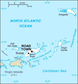 | 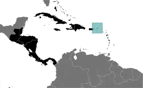 | 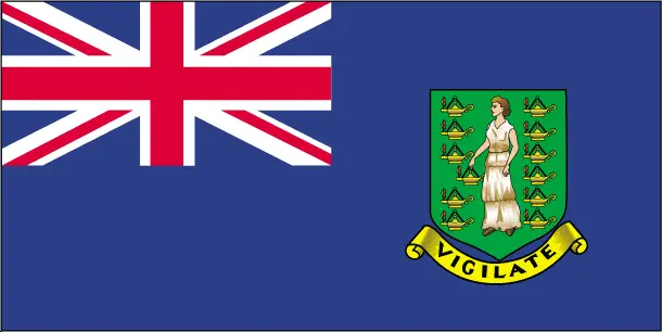 |
Table of contents
- Background
- Overview
- Google Maps
- Climate
- Geography
- Resources and Land Use
- Population Data
- Economic Data
- Drinking Water Source
- Population, Median Age, Migration, and Citizenship
- Average Number of Childbirths
- Is this country a Safe Destination?
- Healthcare and Infectious Diseases
- Natural Hazards
- The Flag and Other Symbols
- Constitution
- Legal System
- About the Unemployment Rate, Labor Force, and Poverty Line
- About the Budget and Central Government Debt
- Inflation Rate and Prime Lending Rate
- Export/Import Partners and Data
- Renewable Energies Used
- Telecommunication Data, Calling Code
- Transport Infrastructure
- More Interesting Facts
Background
The British Virgin Islands (BVI), initially inhabited by the Arawak and later the Carib Indians became a Dutch settlement in 1648 before being annexed by the English in 1672. These islands were part of the British colony of the Leeward Islands from 1872 to 1960 and were granted autonomy in 1967. The BVI’s economy is closely tied to the larger US Virgin Islands, and the US dollar is their legal currency. 2017 Hurricane Irma caused extensive damage, particularly on Tortola, disrupting communications and rendering roads impassable.
Overview
Official Name: British Virgin Islands
Capital: Road Town
Population: 39,369 (2023 est.)
Total Area: 151 sq km (land: 151 sq km, water: 0 sq km)
Population Density: 261 per sq km
Languages: English (official), Virgin Islands Creole
Religions: Protestant (70.2%), Roman Catholic (8.9%), others
Ethnic Origin: African/Black (76.3%), Latino (5.5%), White (5.4%), mixed (5.3%), and other
Government: Overseas Territory of the UK with limited self-government
Currency: US Dollar (USD)
Literacy Rate: Not specified
Calorie Consumption: N/A
British Virgin Islands Google Maps
The British Virgin Islands, nestled in the Caribbean Sea and the North Atlantic Ocean east of Puerto Rico, present an exquisite canvas on Google Maps for travelers seeking Caribbean charm. The platform allows users to virtually navigate through its numerous islands, including Tortola, Anegada, Virgin Gorda, and Jost van Dyke.
The map below shows the British Virgin Islands with its cities, towns, highways, main roads, streets, and Street Views. To find a location, use the form below, type any city or place, view a simple map, and click the “show map” button.
The Google Maps above shows the British Virgin Islands with its location: Central America and the Caribbean (geographic coordinates: 18 30 N, 64 30 W) and the international borders of the British Virgin Islands; 0 km; furthermore, its inland counties boundaries.
The British Virgin Islands, Central America, and Caribbean maps are for informational use only. No representation is made or warrantied given any map or content by Driving Directions and Maps site. The user assumes all risks of using this British Virgin Islands Google Maps and facts/wiki.
Climate
The British Virgin Islands (BVI), with their subtropical climate, offer a fascinating climatic environment that nurtures a rich and diverse array of flora and fauna. Let’s delve into the specifics of their climate and its implications:
- Subtropical Climate Characteristics: The BVI enjoys a subtropical climate, which typically means mild to warm temperatures throughout the year. The islands don’t experience significant temperature fluctuations, with average temperatures usually ranging from 22°C (72°F) in the winter to 31°C (88°F) in the summer.
- Moderating Effect of Trade Winds: The trade winds play a crucial role in moderating the climate. These winds, blowing predominantly from the east, help to keep conditions relatively pleasant, particularly during the warmer months. They also contribute to making the BVI a popular destination for sailing.
- Rainfall Patterns: The islands receive an average annual rainfall of about 1150 mm (45 inches). Rainfall is typically higher in the hills and lower in the coastal areas. The wettest months are from September to November, while February to April are usually the driest.
- Hurricane Season: The BVI lies within the hurricane belt, which means it is susceptible to tropical storms and hurricanes, particularly from June to November. These storms can significantly impact the environment and human activities on the islands.
- Flora and Fauna: The subtropical climate of the BVI supports a wide range of plant and animal life. The islands are home to various tropical trees, such as coconut palms and fruit trees, as well as a colorful array of flowers and shrubs. The surrounding seas are rich in marine life, including coral reefs, fish, turtles, and other marine species.
- Coral Reefs and Marine Ecosystems: The warm sea temperatures around the islands support vibrant coral reefs, which are biodiversity hotspots. These reefs are not only vital for marine life but also for protecting the coastline from erosion, especially during storms and hurricanes.
- Climate Change Impacts: Like many other Caribbean islands, the BVI faces challenges related to climate change. These include rising sea levels, increased intensity of hurricanes, and potential impacts on coral reefs due to ocean acidification and warming sea temperatures.
- Microclimates: The BVI’s varied topography, including hills and valleys, creates microclimates. These microclimates can influence local weather conditions, such as rainfall distribution and temperature variations.
- Seasonal Variability: While the climate is relatively stable, there is some seasonal variability. The winter months are generally cooler and less humid, making them more comfortable for outdoor activities.
- Solar Radiation: The islands receive significant solar radiation throughout the year, contributing to warm temperatures and making solar energy a viable option for renewable energy.
The British Virgin Islands’ subtropical climate, characterized by moderate temperatures, trade winds, and distinct wet and dry seasons, plays a fundamental role in shaping its natural beauty and biodiversity. This climate not only makes the islands an attractive destination for tourism but also supports a delicate ecological balance that is vital for the local environment and economy.
Geography
The geography of the British Virgin Islands (BVI) indeed presents a diverse and intriguing landscape, characterized by a mix of coral and volcanic origins. Here’s a deeper look into the geographical features of the BVI, along with information about its neighboring countries:
- Island Composition: The BVI consists of more than 60 islands and cays, with only around 15 of them inhabited. The islands can be broadly classified into two types based on their geological formation: the majority are of volcanic origin, featuring rugged, hilly terrain, while others are coral islands, characterized by relatively flat landscapes.
- Volcanic Islands: The larger islands in the group, such as Tortola, Virgin Gorda, and Jost Van Dyke, are primarily volcanic. They are known for their steep, hilly terrain, with lush greenery and stunning natural formations. The volcanic nature of these islands has resulted in rich, fertile soil, supporting diverse vegetation.
- Coral Islands: In contrast, the smaller islands and cays, like Anegada, are coral islands. Anegada, the only coral island in the volcanic BVI chain, is notably flat, with its highest point being just about 8 meters above sea level. These coral islands are surrounded by beautiful coral reefs, making them popular for snorkeling and diving.
- Mount Sage: The highest point in the BVI is Mount Sage on Tortola Island, standing at 521 meters (1,709 feet). It is part of the Mount Sage National Park, offering hiking trails that lead to panoramic views of the surrounding islands and sea.
- Beaches and Coastlines: The BVI is renowned for its stunning beaches and crystal-clear waters. The coastlines vary from sandy, white beaches on the coral islands to rocky, rugged shores on the volcanic islands.
- Surrounding Countries and Territories:
- Puerto Rico (USA) to the west,
- U.S. Virgin Islands (USA) to the south and west,
- Anguilla (British Overseas Territory) to the east,
- Saint Martin/Sint Maarten (French and Dutch territory) to the east.
- Marine Ecosystems: The surrounding waters of the BVI are rich in marine life, including vibrant coral reefs, mangroves, and seagrass beds. These ecosystems support a variety of marine species and are crucial for the local fishing industry as well as for ecological balance.
- Climate Impact on Geography: The BVI’s geography is influenced by its subtropical climate, with weather patterns contributing to the lushness of the vegetation on the volcanic islands and the health of the coral reefs around the coral islands.
- Environmental Challenges: The islands face environmental challenges such as coastal erosion, coral bleaching, and the impact of hurricanes. Conservation efforts are underway to protect the delicate ecosystems.
- Tourism and Natural Beauty: The BVI’s diverse geography, combined with its beautiful beaches and clear waters, makes it a popular destination for tourism, especially for sailing, diving, and eco-tourism.
The British Virgin Islands’ unique blend of volcanic and coral island geography, along with their location amidst other Caribbean islands and territories, creates a dynamic and visually stunning landscape that is as ecologically important as it is beautiful.
Resources and Land Use
Natural resources are negligible, but the islands’ pleasant climate and beautiful beaches foster a thriving tourism industry. Agricultural land accounts for 46.7% of the land use, focusing on fruits, vegetables, and livestock.
Population Data
With a population of around 39,369, the BVI exhibits a fairly even distribution across its inhabited islands. The largest populations reside in Tortola, Anegada, Virgin Gorda, and Jost van Dyke.
Economic Data
The BVI’s economy primarily revolves around tourism and services. The islands are known as a tax haven and face challenges such as high electrification costs and vulnerability to hurricanes.
Drinking Water Source
Improved water sources cater to 99.9% of the population. Desalination plants are a primary source due to limited natural freshwater resources.
Population, Median Age, Migration, and Citizenship
The median age in the BVI is 38.2 years. The territory sees a net migration rate of 13.2 migrants/1,000 population, indicating its attractiveness as a destination for expatriates.
Average Number of Childbirths
The total fertility rate is 1.37 children born/woman, reflecting a modern, low birth rate trend similar to that of other developed regions.
Is this country a Safe Destination?
The British Virgin Islands are generally safe for tourists, with standard precautions advised for international travelers.
Healthcare and Infectious Diseases
Healthcare facilities in the BVI are adequate, but serious cases may require evacuation. Common infectious diseases are those typical of the Caribbean region.
Natural Hazards
The islands are prone to hurricanes and tropical storms, particularly from July to October.
The Flag and Other Symbols
The BVI flag features the UK flag in the upper quadrant and the Virgin Islander coat of arms. The national symbol includes the Zenaida dove and the white cedar flower.
Constitution
The current constitution of the BVI, effective from June 15, 2007, provides the framework for its governance as a British Overseas Territory with internal self-government.
Legal System
The legal system is based on English common law, with the Eastern Caribbean Supreme Court serving as the superior court.
About the Unemployment Rate, Labor Force, and Poverty Line
Unemployment rate data is limited, with the last estimate in 2015 at 2.9%. Poverty line statistics are not specified.
About the Budget and Central Government Debt
The BVI’s revenues and expenditures were estimated at $400 million in 2017, balancing the budget.
Inflation Rate and Prime Lending Rate
The inflation rate in the BVI was about 4.2% in 2022, indicative of the economic situation post-hurricane recovery.
Export/Import Partners and Data
Major exports include aircraft and recreational boats, primarily to Malta, Seychelles, and Switzerland. Imports from Germany and the United States include refined petroleum and cars.
Renewable Energies Used
Renewable energy sources are limited, with most electricity generated from fossil fuels.
Telecommunication Data, Calling Code
The telecom sector includes fixed-line and mobile cellular services, with the country code +1-284.
Transport Infrastructure
Transportation infrastructure includes four airports, with only two having paved runways and a total of 200 km of paved roadways.
More Interesting Facts
The British Virgin Islands are renowned for their sailing destinations and are popular spots for yachting and water sports, drawing visitors from around the globe to their serene and beautiful shores.
Did You Know?
- Volcanic and Coral Islands: The BVI is an archipelago of over 60 islands and cays, uniquely comprising both volcanic and coral islands. The larger islands like Tortola and Virgin Gorda are volcanic with rugged terrain, while Anegada is a flat coral island.
- Mount Sage, the Highest Peak: The highest point in the BVI is Mount Sage on Tortola, standing at 521 meters (1,709 feet). The peak is part of the Mount Sage National Park, known for its lush rainforest and hiking trails offering spectacular views.
- Sailing Capital of the World: The BVI is often referred to as the “Sailing Capital of the World.” The islands’ location, consistent trade winds, beautiful weather, and well-equipped marinas make them a premier destination for sailors.
- Underwater National Park: The BVI’s first and only underwater national park, The RMS Rhone Marine Park, is located off Salt Island. It features the wreck of the RMS Rhone, a ship that sank during a hurricane in 1867 and is now a popular dive site.
- Unique Legal System: The BVI operates under a legal system based on English common law. Interestingly, it’s also a leading offshore financial center, with a significant presence in global finance and business services.
- Anegada’s Lobster Festival: Anegada, the BVI’s only coral island, is renowned for its Lobster Festival. Held annually, this festival celebrates the island’s culinary staple – the spiny lobster – attracting food enthusiasts from around the world.
- Flamingo Haven: Once nearly extinct on the islands, flamingos have been reintroduced, particularly on Anegada, where a small but thriving population can be seen at the Flamingo Pond Overlook.
- Bioluminescent Bays: The BVI is home to bioluminescent bays, like the one at Salt Island, where microorganisms in the water glow in the dark, creating a magical nighttime spectacle.
- Pirate History: The islands have a rich history of piracy. Norman Island is reputed to be the inspiration for Robert Louis Stevenson’s famous novel “Treasure Island”.
- Cultural Melting Pot: The BVI has a rich cultural heritage, influenced by African, European, and Indigenous peoples. This diversity is reflected in the islands’ music, dance, and festivals.
- Conservation Efforts: Recognizing the importance of their natural ecosystems, the BVI has several protected areas and ongoing conservation efforts, particularly aimed at protecting coral reefs and mangrove forests.
These intriguing facts about the British Virgin Islands highlight the archipelago’s unique blend of natural beauty, rich history, and cultural diversity, making it a fascinating destination in the Caribbean.
Many thanks for visiting and sharing this map & country information site!