
Driving Directions and Google Map of Norway — Roads, Routes & Navigation Guide
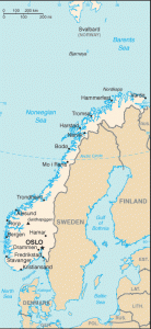
Norway — Norge in Bokmål, Noreg in Nynorsk — is a long, narrow Scandinavian country stretching from the Skagerrak strait in the south to the North Cape (Nordkapp) above the Arctic Circle in the north, covering 385,207 km² of mainland territory. Its extraordinarily rugged geography — deep fjords cutting inland from the Atlantic, mountain plateaus (vidder), glaciers, and a serrated coastline of over 50,000 km including islands — makes Norway one of the world’s most challenging and breathtaking countries to drive through. The country borders Sweden to the east, Finland to the northeast, and Russia to the far northeast (at Storskog, Norway’s sole land border with Russia).
Norway drives on the right-hand side of the road with left-hand drive vehicles. Speed limits are in kilometres per hour. The road network is managed by Statens vegvesen (Norwegian Public Roads Administration) and uses E-prefix European routes (E6, E18, E39, etc.) for primary national and international roads, RV prefix (riksvei) for national roads, and FV prefix (fylkesvei) for county roads. Norway has a distinctive and extensive AutoPASS electronic toll system — there is no vignette; instead, tolls are levied at hundreds of individual toll points across the country, covering motorways, tunnels, bridges, and even ordinary roads serving urban areas.
Norway enforces one of Europe’s strictest drink-drive limits at 0.02% BAC — significantly lower than the EU standard of 0.05%. The currency is the Norwegian Krone (NOK / kr); Norway is not an EU member (it is an EEA/EFTA member), has not adopted the euro, and retains full national sovereignty over taxation and infrastructure policy. Norway joined the Schengen Area in 2001, so internal borders with Sweden, Finland, and Denmark are open for EU/Schengen citizens. Emergency numbers in Norway are 112 (Police/Politiet), 113 (Ambulance), and 110 (Fire). Use the route planner on our homepage to plan your driving routes across Norway.
The Norwegian Road Network
Norway’s road network is managed by Statens vegvesen (Norwegian Public Roads Administration — NPRA) for national roads and by the 15 county authorities (fylkeskommuner) for county roads. Since regional reform in 2024, some roads have been reclassified between national and county categories. Norway’s total road network is approximately 95,000 km; national roads (E and RV) account for roughly 10,000 km. Due to Norway’s extreme topography, the national road network is heavily supplemented by ferry crossings — many officially part of national roads and included in Norwegian driving time calculations — and long road tunnels that bore through mountain ranges and under fjords.
Norway’s motorway standard (class A) roads — true motorvei — total only approximately 700 km, making the motorway network comparatively short for a country of Norway’s size. The limited motorway coverage reflects both the challenging terrain and historically lower population density outside the Oslo–Bergen–Stavanger triangle. However, many national roads in the Oslo region and on the E6 spine are dual carriageway standard, offering motorway-like capacity.
Primary E-roads and national routes:
- E6 — Oslo–Trondheim–Mo i Rana–Narvik–Tromsø–Kirkenes (~2,600 km, Norway’s longest road): The backbone of Norway’s road network, running the full length of the country from the Swedish border at Svinesund in the south to Kirkenes in the far northeast (near the Russian border). The E6 passes through Oslo, Hamar, Lillehammer (1994 Winter Olympics), Trondheim (third-largest city), Mo i Rana (Arctic Circle crossing), Fauske, Narvik (road/rail terminus for iron ore), and continues to Tromsø and Alta. North of Fauske, the E6 passes through dramatic Arctic scenery; the section through Saltfjellet mountain plateau can close in severe winter weather. Journey time Oslo–Trondheim approximately 7 hours (500 km); Oslo–Tromsø by road is approximately 18–20 hours (1,900 km). The E6 south of Oslo forms part of the Corridor between Scandinavia and the European continent via Sweden.
- E18 — Kristiansand–Drammen–Oslo–Swedish border (~340 km, western and eastern approaches to Oslo): The southern coastal motorway, one of Norway’s most heavily used roads. The E18 connects the Swedish border at Svinesund/Halden (east of Oslo) through Oslo and westward to Drammen, then southeast to Kristiansand on the south coast — the port for ferries to Denmark (Color Line, Fjord Line). The Oslo western section of E18 (Sandvika–Oslo) is among Norway’s most congested sections. Journey time Kristiansand–Oslo approximately 3 hours (280 km).
- E39 — Kristiansand–Stavanger–Bergen–Ålesund–Trondheim (the Coastal Highway, ~1,200 km, mostly single carriageway): The western coastal route connecting major cities along Norway’s Atlantic fjord coast. The E39 is famous for its numerous fjord ferry crossings — between Stavanger and Kristiansand (ferry at Stavanger), Bergen and the northern fjord region (multiple ferries), and along the western fjords to Ålesund and Trondheim. Norway’s government has initiated the ambitious Ferjefri E39 (Ferry-Free E39) project, aiming to replace all fjord ferry crossings with tunnels or bridges, including a planned subsea floating tunnel under the Sognefjord — the world’s deepest and longest fjord. Journey time Bergen–Trondheim via E39 is approximately 8–10 hours depending on ferry connections.
- E16 — Oslo–Hønefoss–Flåm–Bergen (~490 km): The central east–west crossing from Oslo to Bergen via the Valdres valley and Lærdal. This route is anchored by the spectacular Lærdal Tunnel — at 24.5 km, the world’s longest road tunnel, opened in 2000. The Lærdal Tunnel connects Aurland to Lærdal through the mountains south of the Sognefjord, eliminating a previously treacherous mountain crossing. Three large illuminated caverns inside the tunnel break the monotony. Journey time Oslo–Bergen via E16 approximately 5.5–6.5 hours (480 km).
- E134 — Drammen–Haugesund (~380 km, via Hardangervidda): The central mountain crossing between eastern and western Norway, running over the Hardangervidda plateau — Europe’s largest mountain plateau at approximately 1,200–1,400 m elevation. The E134 is one of Norway’s most important inter-regional roads and a key freight route; it is prone to closure in winter due to storms and snowfall on the plateau. The route passes through Notodden, Røldal, and descends to Haugesund (oil services hub) on the west coast.
- E10 — Å (Lofoten) — Swedish border (~520 km, the Lofoten Highway): The route serving the Lofoten and Vesterålen island archipelagos north of the Arctic Circle. The E10 connects the fishing village of Å at the southwestern tip of Lofoten through the islands via bridges and a causeway, continuing through Vesterålen and the mountains of Ofoten to Bjerkvik (junction with E6 near Narvik) and eastward to the Swedish border at Riksgränsen/Bjørnfjell. Driving the Lofoten section of E10 is one of Norway’s supreme scenic experiences, with the rocky loftveggen (Lofoten Wall) mountains rising directly from the Arctic Ocean.
- E69 — E6 junction (Olderfjord)–Nordkapp (~130 km): The road to Norway’s North Cape, the most famous terminus drive in northern Europe and one of the most visited points in the world above the Arctic Circle. The E69 includes the Nordkapp Tunnel (~6.9 km subsea tunnel to Magerøya island), which carries a toll. North Cape is typically accessible May–October; severe snow and ice close the E69 in winter. Reaching Nordkapp requires crossing the Sami territories of Finnmark and is a long drive from Oslo — approximately 2,400 km / 26 hours.
Ferry crossings as part of the road network: Unlike most countries, Norway formally includes car ferries as segments of national and county roads. Ferry crossings on E-roads and national roads (such as E39 Lavik–Oppedal, E39 Mortavika–Arsvågen, and dozens more) are essential parts of through-routes and are not avoidable on many itineraries. Ferry routes operated by Fjord1, Norled, Boreal, and others accept cash and contactless card payment; the AutoPASS tag provides discounted fares on designated ferry routes. Summer ferry bookings are advisable on busy routes. Travel time calculations for Norwegian road journeys should always account for ferry wait times and crossing durations.
Driving Rules and Legal Requirements
Norway enforces a blood alcohol limit of 0.02% BAC (0.2 per mille) — one of the strictest limits in Europe and significantly lower than the EU standard of 0.05%. Professional drivers (bus, taxi, heavy goods) and those operating vessels and aircraft are subject to a 0.00% BAC limit. The Norwegian Police (Politiet) conduct frequent roadside breath-testing checkpoints, particularly on Friday and Saturday nights, on E-road holiday corridors, and near mountain pass areas. Penalties escalate sharply with BAC level: a positive result above 0.02% results in fines (proportional to income), licence suspension, and for higher levels, criminal prosecution and imprisonment. Norway’s drink-drive enforcement is taken extremely seriously and levels that would not result in penalties in most EU countries will result in punishment in Norway.
Mandatory year-round headlights: All vehicles must have headlights — or daytime running lights (DRL) — switched on at all times while driving, day and night, regardless of weather. Modern EU-type-approved vehicles satisfy this with automatic DRLs; older vehicles must manually switch on dipped headlights.
Speed cameras: Norway has one of Europe’s densest speed camera networks (ATK — automatisk trafikkontroll). Fixed cameras are located at hundreds of points on national roads and motorways throughout the country; their locations are available in GPS navigation apps (though adding them to GPS is legal in Norway, unlike in some countries). Mobile police radar units also patrol. Norway’s camera system monitors average speed over sections as well as point-to-point; driving consistently above the limit between two cameras will still result in a fine.
Winter tyres and studded tyres: Norway requires vehicles to be equipped for winter conditions. Winter friction tyres (non-studded) are required when roads are snow-covered or icy. Studded tyres (piggdekk) are permitted from 1 November to the first Monday after Easter Sunday in most of Norway (1 October to 30 April in the far north counties of Troms and Finnmark); using studded tyres outside these dates incurs a fine. In parts of Oslo and other cities, an additional piggdekkgebyr (studded tyre fee) is levied to fund asphalt dust mitigation. Winter tyres are practically mandatory for any mountain pass or northern Norway drive outside summer.
Mobile phones and distracted driving: Using any handheld device while driving is strictly prohibited. Fines for handheld phone use are very high (NOK 5,000+). Hands-free calling is permitted. Norway also prohibits eating or drinking while driving if it impairs control of the vehicle.
Seat belts: Mandatory for all occupants in all seats. Drivers are personally responsible for ensuring children are correctly restrained.
Child restraints: Children must be in an age/height/weight-appropriate child restraint system. Rear-facing child seats are mandatory until the child is at least 15 months; children should be kept in rear-facing seats as long as possible (up to weight limits of the seat). This is a strict safety culture — Norwegian parents and authorities take rear-facing child seats very seriously.
Overtaking: Solid white centre lines prohibit overtaking. In Norway, many national roads have intermittent solid/broken centre lines reflecting sight-line geometry; observe these precisely. On mountain roads with limited width, the descending vehicle must give way to the ascending vehicle. Give way to approaching traffic when road width requires pulling over at passing places.
Animals on roads: Norway has large wild populations of reindeer (in the north and mountain areas), elk (elg), deer, and in Svalbard, polar bears. Reindeer and elk on roads are a significant collision hazard — elk collisions are often fatal due to the animals’ height causing them to fall directly onto the windscreen. Warning signs indicate animal-crossing zones; reduce speed and watch carefully in these areas, particularly at dusk and dawn.
Speed Limits on Norwegian Roads
Norway does not have a single blanket motorway speed limit — limits vary by section and are frequently set lower than in many EU countries, reflecting road geometry, safety data, and environmental policy. Variable message signs (VMS) are extensively deployed on national roads and motorways, with real-time limits changing based on weather, traffic, and incidents.
| Road Type | Typical Limit | Notes |
|---|---|---|
| Built-up areas (urban) | 50 km/h | 30 km/h in school zones, residential zones, and pedestrian-priority streets |
| National and rural roads | 80 km/h | May be reduced to 70 or 60 km/h on twisting roads and in hazardous sections |
| Dual carriageway (non-motorway) | 90 km/h | Many E-road sections outside Oslo |
| Motorways (motorvei) | 100–110 km/h | 110 km/h on best-quality motorway sections near Oslo (E6, E18); most motorways 90–100 km/h |
Zero-tolerance for speeding above 30 km/h over limit: Norwegian penalty structure is notably strict. Fines are income-proportional (based on daily income units). Exceeding the limit by 25–30 km/h results in a large fine plus licence suspension; by more than 30 km/h results in criminal charges and confiscation of the vehicle. Speeding above 50 km/h over the limit results in automatic imprisonment. Unlike many EU countries, Norwegian fines are levied as day-fines scaled to income — meaning the same violation can result in very different nominal fines for different individuals.
Tunnel speed limits: Most road tunnels in Norway have a posted speed limit of 70 or 80 km/h regardless of the surrounding road limit. In very long tunnels (such as the Lærdal Tunnel), strict 80 km/h limits and no-overtaking rules apply throughout.
AutoPASS Tolls and Road Pricing
Norway operates one of the world’s most extensive road toll systems via AutoPASS — an RFID-based electronic toll system that uses gantries with cameras and tag readers to record vehicle passages automatically. There is no vignette for Norway; instead, individual toll charges are levied at hundreds of points across the country: motorway toll rings, urban congestion charging cordon zones (Oslo, Bergen, Stavanger, Trondheim), individual tunnel and bridge toll points, and ferry crossings on national roads.
AutoPASS tag: An AutoPASS transponder tag (brikke) mounted behind the windscreen automatically deducts tolls from a pre-registered account, typically at a 20% discount compared to unregistered passage. AutoPASS is interoperable with Swedish Eurovignette and Scandinavian Toll Service systems; Danish and Swedish tags (BroBizz, Easygo) also work on Norwegian toll gantries. Tags can be obtained from AutoPASS service providers or the Fjellinjen/APCOA portal (autopass.no). For rental vehicles, the rental company will typically have an AutoPASS arrangement; check your rental agreement for details and any admin fees.
Foreign vehicles without AutoPASS: Since Norway’s toll system is fully barrier-free, foreign vehicles driving without a registered tag are identified by ANPR cameras. The toll operator will:
- For vehicles registered in Scandinavia or countries with interoperability: charge via the home-country toll account.
- For vehicles from other European countries: use the EasyGo system (easygopayment.com) for after-the-fact billing, or send an invoice to the vehicle’s registered owner address.
- Visitors can pre-register foreign vehicles at autopass.no to receive a discounted rate and avoid invoice charges.
Oslo toll ring (bomring): Oslo operates a congestion charging cordon zone around the city and wider Oslo region. Multiple toll stations form a ring; charges vary by time of day (peak/off-peak), vehicle type, and whether the vehicle is zero-emission. Battery electric vehicles (BEVs) receive a significant toll discount. The Oslo toll ring is one of the busiest toll systems in the world by number of passages per day. As of 2025–2026, Oslo BEV toll rates vary; verify current rates at fjellinjen.no.
Bergen toll ring: Bergen operates its own cordon charging system; similar time-of-day pricing and EV discounts apply.
Typical toll costs (2025–2026, NOK, passenger car Category 1 without tag):
| Toll Point | Approx. Cost (NOK) |
|---|---|
| Oslo toll ring — single passage (peak) | NOK 34–52 |
| Bergen toll ring — single passage | NOK 23–52 |
| Nordkapp Tunnel (E69) | NOK ~160 |
| Ryfylke Tunnel (Stavanger area) | NOK ~145 |
| Typical E6/E18 motorway toll section | NOK 20–60 |
| Ferry crossing (car, typical E39 crossing) | NOK 120–280 |
Toll costs on a full Norway driving holiday can accumulate significantly — budget NOK 500–1,500 or more for a week’s driving depending on itinerary, with higher amounts for western fjord regions where toll tunnels and ferry crossings are numerous. AutoPASS tags and pre-registration substantially reduce costs. All toll charges in Norway are in Norwegian Krone (NOK); credit/debit card is accepted at all staffed ferry terminals.
Fuel, Electric Vehicles, and Charging
Fuel is available throughout Norway, including in small towns on E-roads and national routes. However, in very remote northern Norway areas (Finnmark, northern Troms), stations may be spaced 80–120 km apart, particularly on secondary roads and in Svalbard (where you must fuel at Longyearbyen). Major fuel brands include Circle K (formerly Statoil), Uno-X, Esso, and Shell. Fuel prices in Norway are among the highest in Europe, reflecting high Norwegian excise taxes on fossil fuels as part of environmental policy. Diesel is slightly cheaper than petrol but both carry significant tax loads. LPG is not widely available. E10 petrol (10% ethanol blend) has been standard since 2021.
Electric vehicles — Norway is the world leader: Norway has the highest per-capita rate of battery electric vehicle (BEV) adoption in the world. In 2025, over 80% of new car registrations in Norway were fully electric. This has driven the development of one of the densest EV charging networks in Europe relative to population and area. Key facts for EV drivers:
- Fast DC charging (50–300 kW): Available at regular intervals along E6, E18, E39, E16, and other major E-roads. Operators include Recharge (formerly Fortum Charge & Drive), Mer (formerly Mer/Grønn Kontakt), Tesla Supercharger, Ionity, and Circle K Electric. Journey times on E6 Oslo–Trondheim are feasible with 2–3 fast-charging stops.
- Remote areas: Very long stretches of northern Norway and mountain routes can still have limited charging infrastructure; plan carefully using PlugShare, Chargemap, or the Recharge app. Carry a standard Type 2 cable and know the locations of emergency Level 2 chargers at hotels and guesthouses (hytter).
- Ferry charging: Many Fjord1, Norled, and Boreal car ferries have onboard EV charging points (Type 2, typically 11–22 kW) available during crossings — useful on E39 fjord ferry routes.
- Toll discounts: Battery electric vehicles receive significant AutoPASS toll discounts (currently 50% in many toll rings, though policy evolves — check autopass.no for current rates).
- Free or reduced ferry fares: BEVs receive discounted ferry fares on many Fjord1 and Norled routes — confirm at booking.
- Winter range: Cold temperatures significantly reduce BEV range in Norway; plan for 20–30% range reduction in sub-zero conditions, and more in severe Arctic cold (-20°C and below in Finnmark).
National Tourist Routes and Scenic Drives
Norway has designated 18 National Tourist Routes (Nasjonale turistveger) — officially curated scenic driving routes notable for their outstanding landscapes and architecturally designed rest areas, viewing platforms, and road art. These routes are managed by Statens vegvesen and signposted with a distinctive brown road sign bearing the Norwegian Tourist Route emblem. Below are the most celebrated:
Trollstigen (RV63 — Ørsta/Geiranger direction, Møre og Romsdal): Perhaps Norway’s single most iconic drive, Trollstigen (“The Troll’s Ladder”) is a steep, hairpin-filled mountain road ascending 850 metres through 11 hairpin bends in the Rauma municipality. The road — opened in 1936 — passes the Stigfossen waterfall (180 m) and offers views back down the valley that are among the most dramatic in Norway. Trollstigen is closed in winter (typically November to late May); the precise opening date varies with snowmelt. A large visitor centre with viewing platforms sits at the summit. Due to its 1:12 gradient, buses and caravans above certain lengths are restricted; check current restrictions.
Atlantic Ocean Road (Atlanterhavsveien, RV64 — National Tourist Route): The Atlantic Ocean Road is an 8.3-kilometre section of RV64 in Møre og Romsdal, connecting the islands of Averøy and Eide via a series of low bridges and causeways across skerries and islets in the open Atlantic. The road — built 1983–1989 — has been voted Norway’s “Construction of the Century” and is featured in virtually every Norway tourism campaign. The Storseisund Bridge, the road’s largest span, curves dramatically upward in a way that appears to end in mid-air from certain angles. The Atlantic Ocean Road can experience powerful waves washing across the road during storms — conditions to be respected. Travel is enjoyable year-round; storm-watching in autumn/winter is popular.
Hardanger (National Tourist Route — Hardangerfjord area): The Hardanger region in Vestland county contains some of Norway’s most celebrated scenery: the Hardangerfjord (one of Norway’s longest and most majestic fjords at 179 km), the Vøringsfossen waterfall (183 m free fall), the Hardangervidda plateau, and the famous fruit orchards of Hardanger valley (spectacular in blossom season, late April–May). The RV550 across the Hardangervidda connects the fjord to eastern Norway; the Hardangerbrua suspension bridge (1,380 m, opened 2013) spans the Hardangerfjord on E134, allowing an alternative route without ferry.
Sognefjellsvegen (RV55 — Lom to Skjolden): The highest mountain road in northern Europe, crossing the Sognefjellet pass at 1,434 m above sea level. The RV55 traverses the Jotunheimen National Park region between Lom in Gudbrandsdalen and Skjolden at the head of the Sognefjord. The road is closed in winter (typically November to late May) and is accessible only to non-motorhome vehicles above a certain size. Extraordinary alpine scenery with glaciers, snowfields, and mountain lakes.
Lofoten (E10 — Å to Fiskebøl/Svolvær, ~170 km): Driving the Lofoten Islands chain along the E10 is among the most memorable road journeys in all of Europe. The dramatic Lofoten Wall of jagged peaks rises directly from the Arctic Ocean; fishing villages perched on rocky skerries, red-painted rorbu fishermen’s cabins, and clear Arctic light (midnight sun in summer, northern lights in winter) create unforgettable scenery. The E10 connects the islands via bridges, causeways, and one submarine tunnel; a car ferry to the mainland is required for access at either end from the south (Bodø ferry to Moskenes) or east (driving via Bjerkvik). The circular Lofast road (E10 Svolvær to RV85 back to E6) allows a loop without backtracking.
Geirangerfjord (RV63 / RV60): The Geirangerfjord — a UNESCO World Heritage Site — is accessed by road via the Eagle Road (Ørnevegen) descending to Geiranger village, or via the even more dramatic Geiranger–Trollstigen mountain road. The fjord is visited by cruise ships and ferries from Hellesylt (a classic ferry route). The Seven Sisters and Bridal Veil waterfalls cascade from the fjord walls. The area is only accessible by road from late spring through early autumn.
Driving in Oslo, Bergen, and Trondheim
Oslo: Norway’s capital and largest city (~700,000 city / ~1.1 million metropolitan area) has an extensive automated toll ring system that surrounds the city region. Driving in central Oslo is actively discouraged by policy: parking is expensive, heavily restricted, and systematically reduced — the municipality has removed approximately 700 street parking spaces in the city centre as part of a car-free city centre initiative. The T-bane (metro), tram, and bus network are highly developed. For tourist drivers, the recommended approach is to park at a peripheral park-and-ride facility and use public transport for city centre access. The E18 west corridor and E6 approaches to Oslo are heavily congested during peak hours (07:30–09:00 and 15:30–17:30). The Oslo Fjord Tunnel (E18 Bjørvika, toll-free for cars) and the Oslo Ring 3 (Rv150) provide bypass routing.
Bergen: Norway’s second city (~290,000) and gateway to the fjords. Bergen’s historic Bryggen wharf (UNESCO World Heritage) is pedestrianised. The city is compact; most tourist sights are within walking distance. The E39 enters Bergen from the south via the Puddefjord bridge; from the north, approach is via the E16/RV555 Sotra Bridge and Midthordland tunnel system. Bergen’s toll ring operates similarly to Oslo’s with time-of-day pricing. Bergen is notoriously rainy (over 240 rain days per year) — driving with full headlights and reduced speed is advisable at all times. Bergen Flesland Airport (BGO) is connected to the city by the Bybanen light rail.
Trondheim: Norway’s third city (~210,000) and historic medieval capital. Situated at the mouth of the Niddelva river where the Trondheimsfjord narrows, Trondheim is a major node on the E6 north–south corridor and at the head of the E14 corridor toward Sweden. The city’s ring roads (E6 bypass and Omkjøring bypass) carry through traffic. Downtown Trondheim has a tram network (Gråkallbanen) and extensive cycling infrastructure. Parking in the city centre is zone-regulated.
Stavanger: The fourth-largest city (~150,000; ~370,000 metropolitan) and Norway’s oil capital on the southwest coast. Stavanger is accessed via E39 from the north (ferry from Tau) and south, and via RV509/E39 from the east. The city is the gateway to the famous Pulpit Rock (Preikestolen, a flat-topped cliff 604 m above Lysefjord) — one of Norway’s most visited natural sights. The drive to Preikestolen ferry dock from Stavanger is approximately 45 minutes. Stavanger operates its own toll ring.
Border Crossings with Neighbouring Countries
Norway shares land borders with three countries: Sweden, Finland, and Russia. Norway is a member of the Schengen Area (since 2001 despite not being an EU member), so borders with Sweden and Finland are internal Schengen crossings for EU/EEA citizens — no passport control under normal circumstances. The Russia border at Storskog is a full external border with strict security controls.
Sweden (numerous crossings — internal Schengen): The Norway–Sweden border is the longest Norwegian land border (~1,600 km). Major crossings:
- E6 — Svinesund / Svinesund (Oslo–Gothenburg corridor): Highest traffic volume; motorway standard on both sides. Connects to Swedish E6 toward Gothenburg and Stockholm. The famous Svinesund suspension bridge carries the E6 over the Iddefjord between Norway and Sweden.
- E18 — Ørje / Töcksfors: Secondary east–Oslo crossing toward Karlstad (Sweden) and central Europe.
- E14 — Storlien / Storlien (Trondheim–Östersund): Mountain crossing from Trondheim to central Sweden via Åre (ski resort area).
- E12 — Mo i Rana / Umbukta–Tärna: Arctic crossing through Lapland from northern Norway to Swedish Norrland.
- E10 — Riksgränsen / Bjørnfjell: The northernmost E-road crossing in Lapland, serving Narvik and the Lofoten access route. The railway from Narvik to Stockholm crosses here (the Ofoten/Malmbanan iron ore line).
Finland (several crossings — internal Schengen): The Norway–Finland border is in the far north, crossing through Lapland and Finnmark. Major crossings:
- E8 — Kilpisjärvi / Skibotn: Main crossing in the northernmost “arm” of Norway (Troms county); connects Norwegian E8 to Finnish E8 toward Rovaniemi and Oulu.
- E75 / RV93 — Karigasniemi / Karigasniemi: Crossing in the Tana valley area of Finnmark.
- RV92 — Utsjoki / Ohcejohka: Northernmost crossing near Tana; connects to the Finnish E75.
Russia (one crossing — full border controls):
- Storskog / Borisoglebsk (E105, near Kirkenes): Norway’s sole official road border crossing with Russia, in the far northeastern Finnmark county. Since Russia’s invasion of Ukraine in 2022, this crossing has been largely closed to most civilian traffic by both Norwegian and Russian authorities. Only Norwegian and Russian citizens with valid visas and special permissions may cross, subject to stringent controls. This crossing is not available for general tourist transit. The drive from Oslo to Kirkenes (near Storskog) is approximately 2,500 km and 27 hours.
Road Safety and Emergency Procedures
Norway has one of the lowest road fatality rates in the world — consistently among the top five safest road environments globally, measured in deaths per million inhabitants. This is achieved through strict enforcement, high-quality infrastructure, a safety-conscious driving culture, and vehicle safety standards. Norway’s Vision Zero (Nullvisjonen) programme — the world’s first national road safety programme to explicitly target zero fatalities and serious injuries — was introduced in 2002 and has been widely emulated internationally.
In an emergency: Call 112 for Politiet (Police), 113 for Ambulance (ambulanse), or 110 for Fire Brigade (brannvesen). These are Norway’s dedicated emergency numbers; all work from mobile phones including those without credit. The Norwegian Automobile Federation (NAF — Norges Automobil-Forbund) provides roadside assistance: call 08505 (NAF Veiassistanse). On motorways, emergency telephones are spaced at intervals; look for the distinctive orange NAF roadside emergency phones.
Mountain road and tunnel safety: Norway’s mountain roads can be dangerous in winter, fog, and severe Atlantic weather. The website vegvesen.no provides real-time road status including closures, restrictions, and conditions for all national roads. The app Vegtrafikksentralen and website vegtrafikksentralen.no provides real-time traffic information. Before driving in northern Norway or mountain areas in winter, always check road conditions — closures can happen with little notice due to snowstorms or avalanche risk. The fjellovergang (mountain pass) section of routes like E134 (Hardangervidda), E16 (Filefjell), and RV7 (Hardangervidda northern route) can close for hours to days during severe weather.
Tunnel safety: Norway has approximately 1,200 road tunnels — more than any other country. Long tunnels can cause driver fatigue and disorientation; drive at a steady pace, maintain headlights, and keep distance. In the event of a fire in a tunnel, do not stop; drive out if possible. If driving out is impossible, stop as far to the right as possible, exit the vehicle, and proceed on foot to the nearest cross-passage or emergency exit. Emergency exits are signed inside all tunnels.
Reindeer and elk hazards: Elk (elg) collisions kill several people in Norway each year and injure many more. Elk are tallest at exactly the height to enter through the windscreen on impact — approach warning signs at reduced speed. In Sami reindeer herding areas (most of northern Norway), reindeer cross roads freely and unpredictably at all times of day. Drive slowly through reindeer warning zones and be prepared to stop.
FAQ: Driving in Norway
Do I need a vignette to drive in Norway?
No. Norway does not use a vignette system. Road tolls in Norway are charged at individual toll points (motorway sections, tunnels, bridges, and urban toll rings) using the barrier-free AutoPASS electronic system. There is no single pass or sticker to buy in advance. If you have an AutoPASS-compatible tag, tolls are deducted automatically at a discount. Without a tag, toll charges are recorded by camera and billed to your vehicle’s registered address — or you can pre-register at autopass.no to pay online and receive a discount.
What is the drink-drive limit in Norway?
Norway’s limit is 0.02% BAC (0.2 per mille) — significantly stricter than the EU standard of 0.05%. Professional and commercial drivers face 0.00% BAC. Even small amounts of alcohol can breach the limit; Norwegian police conduct routine breath tests at checkpoints without needing specific suspicion. Penalties are severe and income-proportional. Visitors from countries with a 0.05% or higher limit must be aware that their normal behaviour may be illegal in Norway.
Is Norway in the EU or Schengen?
Norway is not a member of the European Union — it rejected EU membership in referendums in 1972 and 1994. However, Norway is a member of the EEA (European Economic Area) and EFTA (European Free Trade Association), which gives it access to the EU single market. Norway joined the Schengen Area in 2001, meaning there are no passport controls at land borders with Sweden and Finland for EU/EEA citizens. The Norwegian Krone (NOK) is the currency; the euro is not used.
How much will tolls cost for a trip through Norway?
Toll costs vary enormously depending on your route. A day’s driving in southern Norway between cities might accumulate NOK 200–500 in tolls from urban toll rings and motorway sections. A drive through western Norway involving fjord ferry crossings, toll tunnels, and the Bergen and Stavanger toll rings could cost NOK 800–1,500 in a day. For a full week’s holiday driving the western fjords and the E6 north, budget at minimum NOK 2,000–4,000 in tolls and ferry fares. Pre-registering your vehicle at autopass.no or using a compatible tag saves 20% on toll gantry rates and reduces invoice administration.
Are Norway’s mountain roads suitable to drive in winter?
Many of Norway’s most scenic mountain roads are closed in winter — typically from late October/November until late May or even June. This includes Trollstigen, the Geiranger–Trollstigen road, Sognefjellsvegen (RV55), the Hardangervidda RV7 northern route, and many others. Main E-roads (E6, E16, E134) are kept open year-round with priority snowploughing but can have convoys and speed restrictions in severe weather. Always check vegvesen.no before attempting mountain routes in winter. Winter tyres or chains are mandatory when roads are snow-covered.
Can I take my car to the Lofoten Islands?
Yes — Lofoten is accessible by car from the mainland. The most common route from Oslo is via E6 north to Fauske/Bodø, then either a car ferry from Bodø to Moskenes (~3.5 hours, book in advance in summer) or via the E10 Lofast road from Bjerkvik near Narvik. The islands are connected by the E10 via bridges and one subsea tunnel (Lofast). No ferries are required between islands once you are on Lofoten. The drive from Oslo to Moskenes ferry terminal is approximately 1,400 km; plan for 2 days of driving at a minimum.
Are there speed cameras throughout Norway?
Yes. Norway has one of Europe’s densest networks of fixed speed cameras (ATK), with hundreds of cameras deployed on national roads and motorways across the country. Camera locations are made available by Statens vegvesen and are included in most GPS navigation apps. Norway also uses section control (average speed measurement over a stretch of road) at numerous locations — maintaining a higher average speed between entry and exit cameras results in a fine even if no single point was over the limit. Mobile radar units supplement fixed cameras.
Sources and Update Note
This Norway driving guide draws on information from Statens vegvesen (Norwegian Public Roads Administration — vegvesen.no), AutoPASS (autopass.no) for toll system details, Fjellinjen (fjellinjen.no) for Oslo toll ring rates, NAF (Norges Automobil-Forbund — naf.no) for driving rules and emergency assistance, Nasjonale turistveger (nasjonaleturistveger.no) for scenic route information, Visit Norway (visitnorway.com) for road trip guidance, and OpenStreetMap contributor data. EV infrastructure data draws on Recharge (rechargeinfra.com), Mer (mer.eco), and PlugShare community data. Norwegian traffic law citations reference the Vegtrafikkloven (Road Traffic Act) and Trafikkreglene (Traffic Regulations).
Norwegian road tolls, ferry fares, and EV incentive policies are reviewed annually and subject to change. Verify current AutoPASS rates at autopass.no, current Oslo/Bergen toll ring rates at fjellinjen.no and bompengeinfo.no, and mountain road conditions at vegvesen.no. This guide reflects information current as of February 2026.