
Driving Directions and Google Map of Iceland — Roads, Routes & Navigation Guide
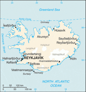
Iceland — Ísland, “Land of Ice” — is a volcanic island nation of approximately 103,000 km² sitting astride the Mid-Atlantic Ridge in the North Atlantic Ocean, just south of the Arctic Circle. With a population of only ~380,000 (two-thirds of whom live in the greater Reykjavík capital region), Iceland is the most sparsely populated country in Europe — yet it receives over two million tourists annually, the vast majority of whom explore the country by car or campervan. Iceland’s extraordinary geology — active volcanoes, geothermal hotsprings, vast lava fields, glaciers covering 11% of the land surface, dramatic fjords, black sand beaches, and cascading waterfalls — makes driving the primary and often only way to experience the full sweep of the country’s landscapes.
Iceland drives on the right-hand side of the road. Speed limits are in kilometres per hour. The road network is managed by Vegagerðin (the Icelandic Road and Coastal Administration). Iceland has no motorways — the highest road category is paved national road, with a maximum speed limit of 90 km/h. The centrepiece of Icelandic driving is the celebrated Ring Road (Hringvegurinn — Route 1), a 1,332 km circular route encircling the entire island that has become one of the world’s most iconic road journeys. Iceland also has an extensive network of F-roads — highland interior tracks passable only with four-wheel drive (4×4) vehicles, typically open from late June to late September only.
Iceland is not an EU member (it is an EEA/EFTA member, like Norway) but joined the Schengen Area in 2001. The currency is the Icelandic Króna (ISK / kr). The emergency number is 112 for all services. Iceland has almost no road tolls — the only significant one is the Hvalfjörður Tunnel north of Reykjavík. Use the route planner on our homepage to plan your Icelandic road trip.
The Icelandic Road Network and Ring Road
Iceland’s road network totals approximately 12,900 km, of which around 8,500 km are paved. Vegagerðin (the Icelandic Road and Coastal Administration) manages national roads; regional and municipal roads are managed by local authorities. There are no motorways in Iceland — the road network consists entirely of single or occasionally dual-carriageway roads, with no grade-separated junctions outside Reykjavík’s immediate ring road approaches. The maximum speed limit anywhere in Iceland is 90 km/h.
The backbone of Iceland’s road network is the Ring Road (Hringvegurinn — Route 1 / Þjóðvegur 1), which circles the entire island for 1,332 km. The Ring Road was completed in 1974 when the last bridge across the glacial rivers of the southeast was finished; before that date, the island had no circumferential road. Today, approximately 80–85% of the Ring Road is paved; the remaining sections are compacted gravel, mainly in the remote east and a few northern stretches. The Ring Road passes through every major region of Iceland: the capital region, the Snæfellsnes approach, north past Borgarnes and Blönduós, east through Akureyri (the “Capital of the North”), past Mývatn (geothermal lake), through the remote eastern fjords, and back south through the glacier-flanked southeast past Skaftafell and Vík before returning to Reykjavík.
Single-lane bridges (einbreiðar brýr): One of the most characteristic features of Icelandic roads is the prevalence of single-lane bridges — bridges wide enough for only one vehicle at a time. These occur on the Ring Road and throughout the country, including over some rivers and gorges with significant drops. The convention is that the vehicle arriving first, or nearest to the bridge, has right of way; the other vehicle must stop and wait. Approaching a single-lane bridge, slow down, check for oncoming traffic, and proceed only when it is clear or when you have right of way. Single-lane bridges are signed and often immediately preceded by a passing place.
Gravel roads: Many Icelandic roads outside the Ring Road — and sections of the Ring Road itself — are unpaved gravel (malbik = paved, malbikaður vegur; möl = gravel). Gravel roads require significant reductions in speed — loose gravel can cause loss of control, and flying stones from oncoming vehicles can crack windscreens. The speed limit on gravel roads is 80 km/h but safe driving speeds are typically 40–60 km/h on loose or rutted gravel. Windscreen damage from gravel is extremely common; check your rental car insurance for gravel/windscreen coverage (standard basic insurance frequently excludes windscreen cracks and tyre damage on gravel).
Primary numbered routes and regional roads:
- Route 1 (Ring Road / Hringvegurinn, 1,332 km): The complete circumferential route. Journey time for the full circuit: 14–17 hours of pure driving; most travellers allow 7–12 days for a proper Ring Road circuit with stops. The traditional direction is clockwise from Reykjavík, heading north through the west and north regions before the remote east. Anticlockwise is equally valid and less common.
- Route 2 — Suðurlandsvegur (South Iceland Road, ~190 km, Reykjavík to Vík): The southern coastal route, one of Iceland’s most visited roads, passing through the Golden Triangle tourist areas, Selfoss, Hella, Hvolsvöllur, and the south coast to Vík í Mýrdal (the southernmost village on the mainland). This stretch of Route 1 passes Seljalandsfoss and Skógafoss waterfalls, Eyjafjallajökull glacier (the volcano whose 2010 eruption disrupted European air travel), and the famous black sand beach of Reynisfjara near Vík.
- Route 35 — Þingvallavegur/Kjölur approach (Golden Circle connection): The road connecting Reykjavík to Þingvellir National Park (UNESCO World Heritage Site — site of the world’s oldest parliament, the Alþing, founded 930 CE) and onward toward Geysir and Gullfoss, forming part of the famous Golden Circle tourist route.
- Route 36 — Þingvallavegur (Golden Circle, ~45 km from Reykjavík to Þingvellir): The direct road from Reykjavík to Þingvellir National Park across the lava plain.
- Route 54 — Snæfellsnessvegur (Snæfellsnes Peninsula, ~150 km from Route 1 junction): The main road serving the Snæfellsnes Peninsula — one of Iceland’s most dramatic regions, dominated by the Snæfellsjökull glacier-volcano (immortalised as the entrance to Jules Verne’s Journey to the Centre of the Earth). The road passes through Grundarfjörður (with views of the iconic Kirkjufell mountain), Stykkishólmur (ferry port for the Westfjords), and around to the glacier at the peninsula’s tip.
- Route 60 — Westfjords main road: The primary road into the Westfjords (Vestfirðir) — Iceland’s most remote and least-visited region, a deeply dissected peninsula of narrow fjords and steep mountain roads in the northwest. The Westfjords have the most challenging road conditions in Iceland outside the F-roads: steep unpaved climbs over mountain passes between fjords, narrow road widths, and limited services. Routes 60, 61, 62, and 63 form the spine of the Westfjords network. The Dynjandi waterfall (the Westfjords’ most famous cascade) is accessed off Route 60.
- Route 1 north — Akureyri approach and Mývatn region (~390 km from Reykjavík): The northern section of the Ring Road reaches Akureyri (Iceland’s second-largest urban area, ~19,000 people) at the head of the Eyjafjörður — Iceland’s longest fjord. From Akureyri, a detour on Routes 848/87 leads around the famous Lake Mývatn (Midge Lake) — a geothermal wonderland of pseudocraters, lava formations, mud pools (hverir), and the Dimmuborgir lava field. Northeast of Mývatn, Route 862 leads to Dettifoss — Europe’s most powerful waterfall by volume (500 m³/s peak flow), dropping 44 metres in the Jökulsárgljúfur canyon.
F-Roads: Highland Interior Routes
Iceland’s highland interior — the Highlands (Hálendið) — is an uninhabited volcanic plateau of lava deserts, glaciers, and geothermal areas at elevations of 400–1,000 metres. It is accessible only via F-roads (fjallvegir — mountain roads), which are designated with an “F” prefix on Icelandic maps and signs. F-roads are fundamentally different from normal roads and require specific preparation:
- 4×4 (four-wheel drive) mandatory: Driving F-roads in a regular two-wheel drive vehicle is illegal and voids all rental car insurance without exception. Most F-roads require high ground clearance in addition to 4WD. Standard compact or economy rental cars are not permitted on F-roads under any circumstances — even if the road looks passable. Rental agreements explicitly exclude F-road coverage for 2WD vehicles, and rescue fees from F-road incidents in non-permitted vehicles fall entirely on the driver.
- Seasonal opening: F-roads are typically open from late June to early to mid-September, depending on snowmelt and annual conditions. Opening and closing dates vary year to year. Vegagerðin publishes official opening dates at road.is; driving closed F-roads risks becoming stuck in snow and mud with no rescue guarantee. Attempting F-roads in spring before official opening is extremely dangerous.
- River crossings (árfærur): Many F-roads include unbridged river crossings (vaðir — fords). Glacial rivers in Iceland can change depth and flow rate within hours due to rainfall or glacial melt. A crossing that is knee-deep in the morning can be waist-deep by afternoon. Before any ford crossing: check the depth by walking it (if safe), assess current speed, keep windows open, drive in low-ratio 4WD at walking pace to maintain a bow wave, and do not stop mid-crossing. Several deaths and many vehicle losses occur in Icelandic river crossings each year. If in doubt, turn back — a wrong decision is fatal.
- Key F-roads:
- F35 — Kjölur (Kjölvegur, ~170 km): The most accessible highland route, running between Gullfoss in the south and Blönduós on the Ring Road in the north. The Kjölur route passes between the Langjökull and Hofsjökull glaciers and has no river crossings — making it the most beginner-friendly F-road. Hot springs at Hveravellir midpoint. Open June–October typically.
- F26 — Sprengisandur (~230 km): The longest highland route, crossing the central lava desert between the Þórsmörk area and Goðafoss in the north. Crosses several rivers; remote and very exposed. Only for experienced 4WD drivers.
- F225 — Landmannalaugar (~50 km from Ring Road): Access road to Landmannalaugar, the famous geothermal bathing area in the Fjallabak Nature Reserve, surrounded by rhyolite mountains in striking shades of red, yellow, green, and purple. Extremely popular; includes a river crossing at the start. The Laugavegur hiking trail begins here.
- F208 — Þórsmörk approach: Access to Þórsmörk (Thor’s Forest) — a sheltered valley between three glaciers, a beloved Icelandic nature destination. Multiple river crossings; can only be driven in purpose-built super-jeeps or well-equipped 4×4 vehicles.
Driving off designated roads or tracks is strictly illegal in Iceland under environmental protection law. Iceland’s moss-covered lava fields and fragile soil are extremely vulnerable to vehicle damage; tracks made by off-road vehicles can persist for centuries. Fines are very high, and enforcement is active. Stay on marked roads and tracks at all times.
Driving Rules and Legal Requirements
Iceland enforces a blood alcohol limit of 0.05% BAC — the EU standard, shared with Finland and Denmark. The Icelandic Police (Lögreglan) conduct breathalyser tests at checkpoints and following accidents. Penalties include fines (income-proportional), driving licence suspension, and criminal prosecution for higher BAC levels.
Mandatory headlights: All vehicles must use dipped headlights (or daytime running lights) at all times while driving, regardless of time of day or weather. Given Iceland’s extreme seasonal light variation — continuous daylight in summer, very limited daylight in winter — headlight use is always required.
Speed cameras: Iceland operates fixed speed cameras on the Ring Road and approach roads to Reykjavík, as well as mobile police radar units. Fines are income-proportional. Speed cameras are not as dense as in other Nordic countries but are present on key routes.
Seat belts: Mandatory for all occupants. Child restraints required for children; rear-facing seats for young children per standard European practice.
Mobile phones: Handheld mobile phone use while driving is prohibited; fines are substantial.
Sheep on roads (kindur á vegi): During summer (roughly May–October), sheep graze freely throughout rural Iceland, including on and adjacent to roads. Sheep are unpredictable and will often walk directly into a vehicle’s path without warning, or bolt suddenly. Collisions with sheep are common and the driver is responsible for damage to the sheep (farmers must be compensated). Reduce speed significantly whenever sheep are visible near the road; be especially cautious at blind corners, crest hills, and narrow sections where sheep may be hidden. The saying in Iceland is: “a sheep will always run toward danger rather than away from it.”
Weather and road conditions: Iceland’s weather is famously volatile; conditions can change from sunshine to whiteout blizzard within minutes, in any month. Vegagerðin’s road condition website (road.is) publishes real-time road status with closures, conditions, and warnings for every route in Iceland — checking road.is before every journey is an essential habit for driving in Iceland. The Safe Travel website (safetravel.is) provides emergency registration for hikers and drivers heading into remote areas.
Off-road driving: Strictly prohibited under Icelandic law (Nature Conservation Act). Driving on vegetation, moss, lava fields, or any unmarked terrain outside designated roads and tracks is illegal, carries large fines, and causes irreversible environmental damage.
Rental car insurance considerations: Standard Collision Damage Waiver (CDW) insurance for rental cars in Iceland typically excludes: damage from gravel/flying stones, windscreen cracks, tyre punctures, river crossing damage, F-road damage (for non-permitted 4WD vehicles), and damage from driving through streams or water. Supplemental insurance packages (SAAP — Sand and Ash Protection; SCDW — Super CDW; GP — Gravel Protection) cover specific risks; visitors are strongly advised to review insurance terms carefully and take appropriate additional cover for their planned itinerary.
Speed Limits on Icelandic Roads
Iceland’s speed limit system is simple but has one distinctive feature: a higher rural paved road limit (90 km/h) than is standard in most European countries (typically 80 km/h). The gravel road limit (80 km/h) is in practice a dangerous maximum rather than a safe target — most experienced drivers on loose or rutted gravel roads travel at 40–60 km/h.
| Road Type | Speed Limit | Notes |
|---|---|---|
| Urban / built-up areas | 50 km/h | 30 km/h in school zones; speed bumps (hraðahamlari) common throughout towns |
| Unpaved / gravel roads | 80 km/h | Legal maximum only — safe driving speed is typically 40–60 km/h; gravel causes windscreen damage and loss of control at speed |
| Paved rural roads (including Ring Road) | 90 km/h | Higher than EU standard of 80 km/h; applies on paved sections of Route 1 and other paved roads outside built-up areas |
Speed bumps (hraðahamlar): Iceland uses speed bumps extensively in towns, villages, and near farms — far more commonly than most European countries. Speed bumps are placed on main roads entering and passing through even tiny communities, often without warning. Approach all settlements at reduced speed to avoid suspension damage from unmarked or poorly signed speed bumps.
Enforcement: Iceland’s speeding fines are income-proportional. Fines are issued on the spot or by post for camera offences. Driving significantly over the limit can result in on-the-spot licence confiscation by police.
Tolls — The Hvalfjörður Tunnel
Iceland has virtually no road tolls. The only significant toll facility in Iceland is the Hvalfjörður Tunnel (Hvalfjarðargöng), a 5.7 km subsea tunnel under the Hvalfjörður fjord approximately 30 km north of Reykjavík, completed in 1998. The tunnel carries Route 1 (Ring Road) and the Reykjavík–Akranes route, eliminating what was a 60 km detour around the fjord. Using the tunnel is optional — drivers can still take the old Route 47 around the fjord head, which adds approximately 45 minutes but is a scenic alternative.
| Vehicle Type | One-Way Toll (ISK, 2025–2026) |
|---|---|
| Passenger car (under 3.5 tonnes) | ISK ~1,000 |
| Motorcycle | ISK ~500 |
| Camper / motorhome (over 3.5 tonnes) | ISK ~2,000 |
Payment is by card at the unmanned toll booths; cash is not accepted. The toll represents very good value given the time and fuel saved. Verify the current toll rate at hvalfjarðargöng.is or at the tunnel booth on approach. There is no other toll, vignette, or road user charge anywhere in Iceland.
Iconic Drives: Ring Road, Golden Circle & Beyond
The Ring Road (Route 1 — full circuit, 1,332 km): Circumnavigating Iceland on the Ring Road is one of the great road journeys of the world. The traditional 7–10 day clockwise circuit from Reykjavík passes through every major landscape type: the lava fields and mountains of the west, the dramatic north coast fjords, the otherworldly geothermal region of Mývatn, the remote eastern fjords and fishing villages, the glacier-flanked southeast (Vatnajökull — Europe’s largest glacier by volume, covering 8% of Iceland) with its famous glacier lagoon at Jökulsárlón, and the south coast waterfalls. Key Ring Road highlights:
- Jökulsárlón Glacier Lagoon (southeast, Route 1): A deep glacier lagoon where icebergs calve from the Breiðamerkurjökull outlet glacier of Vatnajökull and float slowly to sea. Boat tours available in summer. Diamond Beach — where ice chunks wash up on the black sand — is immediately adjacent.
- Skaftafell and Vatnajökull National Park (southeast): Iceland’s largest national park, encompassing Vatnajökull glacier and the outwash plains around it. Glacier hikes and ice cave tours depart from Skaftafell.
- Vík í Mýrdal (south coast): Iceland’s southernmost village, flanked by the black volcanic beach of Reynisfjara (with its basalt sea stacks — Reynisdrangar) and the looming Mýrdalsjökull glacier above. The beach is famous but dangerous — sneaker waves kill visitors every year; stay well back from the water’s edge.
- Mývatn (north): A geothermally active lake district with pseudo-craters, lava pillars (Dimmuborgir), mud pools and fumaroles (Námaskarð / Hverir), a geothermal swimming pool (Mývatn Nature Baths), and rich birdlife. One of Iceland’s most concentrated areas of natural phenomena.
- Goðafoss (north): The “Waterfall of the Gods” on Route 1 east of Akureyri — where Iceland’s law-speaker Þorgeir Ljósvetningagoði cast his Norse idols into the falls after Iceland adopted Christianity in 1000 CE.
- Akureyri (north): Iceland’s second-largest urban area (population ~19,000) at the head of the 60 km Eyjafjörður. Noted for its botanical garden (the world’s northernmost botanical garden above the Arctic Circle), colourful houses, and the distinctive Akureyrarkirkja church above the town.
The Golden Circle (Gullni hringurinn, ~300 km day trip from Reykjavík): The most popular tourist driving circuit in Iceland, combining three iconic sites accessible in a single day from the capital. The route typically follows Route 36 to Þingvellir, then Route 365 to Geysir, then Route 30 to Gullfoss, returning to Reykjavík via Route 35.
- Þingvellir National Park (UNESCO World Heritage): The site of the world’s oldest parliament (the Alþing, founded 930 CE), set on the rift valley where the Eurasian and North American tectonic plates are visibly pulling apart at approximately 2 cm per year. Divers and snorkellers swim in the Silfra fissure in crystal-clear glacially filtered water with visibility exceeding 100 m.
- Geysir geothermal area: The original Geysir (from which the English word “geyser” derives) erupts irregularly; the adjacent Strokkur erupts reliably every 4–10 minutes, shooting a column of boiling water 15–30 m into the air. The surrounding geothermal field has hot springs, mud pools, and fumaroles.
- Gullfoss (Golden Falls): A dramatic two-tiered waterfall on the Hvítá glacial river, dropping a combined 32 metres. In sunshine the spray creates rainbows — giving the falls their “golden” appearance. One of Iceland’s most-photographed natural features.
The South Coast (Route 1 / Route 2 — Reykjavík to Vík, ~190 km): Among Iceland’s most rewarding day drives, the south coast route from Reykjavík east passes Seljalandsfoss (where you can walk behind the waterfall), Skógafoss (a 60 m curtain waterfall with a hiking trail to the top), the flanks of Eyjafjallajökull volcano, and the black beach at Vík. This is one of the most visually varied and scenic sections of road in Iceland.
The Snæfellsnes Peninsula (Routes 54/574, ~200 km from Reykjavík): The Snæfellsnes Peninsula is Iceland in miniature — glaciers, lava fields, fishing villages, sea cliffs, and the iconic Kirkjufell mountain (the most-photographed mountain in Iceland) all within a 90 km peninsula. Snæfellsjökull glacier at the tip is a national park and Jules Verne’s fictional entrance to the Earth’s centre. The drive around the peninsula via Routes 54 and 574 is one of Iceland’s finest scenic circuits.
The Diamond Circle (northeast — Akureyri region, ~250 km): A northeast Iceland scenic circuit taking in Dettifoss (Europe’s most powerful waterfall), the Ásbyrgi horseshoe canyon, the Jökulsárgljúfur canyon (where the river has carved canyons through a volcanic plateau), Húsavík (Iceland’s whale-watching capital, where some of the world’s best humpback whale encounters occur just offshore), and Goðafoss waterfall.
Seasonal Driving: Summer, Winter, and Weather
Summer driving (June–August): Iceland’s peak tourist season coincides with the midnight sun — in June, there is essentially no darkness at all in Iceland; the sun sets briefly around midnight and rises again within the hour. Road conditions are generally at their best in summer: most roads are passable, F-roads are open, and the weather, while changeable, is at its mildest (typical temperatures 10–15°C in Reykjavík). Summer also brings the heaviest tourist traffic, particularly on the Ring Road south coast and Golden Circle; rental cars and campervans can cause congestion at popular viewpoints.
Winter driving (November–March): Winter in Iceland is a dramatically different experience. Daylight is very limited (as little as 4–5 hours in December). Road closures are frequent due to snowstorms, ice, and blizzards. The Ring Road is kept open year-round with priority snow ploughing, but sections close regularly, sometimes for hours, during severe weather. Mountain passes and highland routes close for the winter season. The road.is website is the essential tool for checking road status in real time: roads are colour-coded (green = open, yellow = caution, orange = difficult, red = closed). Never drive a closed road in Iceland — the penalties are severe and the risks extreme.
Rental car requirements in winter: Rental cars in Iceland from October to May will be equipped with studded winter tyres (mandatory for rental car operators during winter). Self-drive travellers bringing their own vehicles must have winter tyres fitted by law from 1 November.
Specific weather hazards:
- High winds: Iceland regularly experiences some of the highest wind speeds in Europe. Wind gusts above 30 m/s (108 km/h) occur multiple times per year, particularly in the southwest and northwest. High-profile vehicles (camper vans, motorhomes) are at serious risk of being blown off the road or tipping in extreme gusts. Vedur.is (Icelandic Met Office) publishes wind warnings; if a severe wind warning (hviðaviðvörun) is in force, consider delaying your journey, particularly with a high vehicle.
- Sandstorms and volcanic ash: The black sand deserts of south Iceland (the Mýrdalssandur and Skeiðarársandur outwash plains) are subject to volcanic sandstorms that can strip paint from vehicles and cause total zero-visibility whiteouts. Sandstorm warnings are issued by Vedur.is; the SAAP (Sand and Ash Protection) insurance add-on is strongly recommended for south Iceland routes. Sand and ash damage is not covered by standard CDW rental insurance.
- River flash floods: Glacial rivers in Iceland can rise dramatically and without warning due to rainfall on glaciers or sub-glacial geothermal heating. Never attempt to ford a river that looks higher than usual; check road.is for river level warnings.
- Volcanic eruptions: Iceland experiences frequent volcanic eruptions, particularly in the Reykjanes Peninsula area (which has had recurring eruptions since 2021) and the Vatnajökull volcanic zone (including Grímsvötn and Bárðarbunga). Active eruption areas are closed by police and civil protection authorities; follow all closures. Eruptions can generate hazardous gases (SO₂, H₂S), ash falls that damage roads and vehicles, and lava flows that block roads.
Fuel, Electric Vehicles, and Charging
Fuel stations are found in all towns and larger villages throughout Iceland, including in the north (Akureyri, Húsavík) and east (Egilsstaðir, Höfn). However, on some sections of the Ring Road — particularly the remote east fjords between Höfn and Egilsstaðir, and some north coast sections — fuel gaps can be 100–150 km. Always refuel when passing a fuel station in remote areas; do not wait until near-empty. Major fuel brands include N1 (Icelandic, the largest network), Orkan, and Shell. Most stations are unmanned self-service; payment by chip-and-PIN card is the norm. Petrol and diesel are widely available; fuel prices in Iceland are high, reflecting import costs and taxes. Some stations in remote areas accept cash; carry card for all circumstances.
Electric vehicles: Iceland’s geothermally generated electricity is among the cheapest and cleanest in the world (almost 100% from renewables — hydro and geothermal), making EV driving in Iceland very cost-effective at charging points. EV infrastructure in the Reykjavík metropolitan area is excellent; charging points exist at parking facilities throughout the capital. On the Ring Road, fast chargers (50 kW DC) have been installed at N1 and Orkan stations at regular intervals, making the complete Ring Road circuit feasible in a modern long-range EV. Key gaps remain in the remote east fjords and Westfjords; careful range planning is required. Cold winter temperatures significantly reduce battery range — plan for 25–35% range reduction in winter driving conditions. Check PlugShare or the Charge.is network map for current charger locations along your planned route.
Road Safety and Emergency Procedures
Iceland has a relatively low road fatality rate for its population but a disproportionately high accident rate for tourists — due to unfamiliarity with local road conditions, gravel roads, single-lane bridges, sheep, sudden weather changes, and the temptation to drive while fatigued during the midnight sun season. The most common tourist accidents involve leaving the road on gravel sections, unexpected speed bumps, and attempting to cross unsafe rivers.
In an emergency: Call 112 for all emergency services — Police (Lögreglan), Ambulance, and Fire/Rescue. Iceland Mountain Rescue (Landsbjörg), organised through volunteer ICE-SAR teams, handles wilderness rescues. For non-emergency assistance, register your travel plans at safetravel.is before heading into remote areas — if you fail to check in as planned, rescue teams are alerted. This is strongly recommended for F-road trips, Westfjords travel, and any remote winter driving. Roadside breakdown assistance is provided through rental car company contracts and through the FÍB (Icelandic Automobile Association).
Road.is app and website: The Vegagerðin road conditions website (road.is) is essential for all Iceland driving. It shows real-time road status, closures, conditions, and hazard warnings for every route in Iceland, updated continuously. Download the app before your trip. No Iceland driving journey should begin without checking road.is.
Emergency facilities: Emergency shelters (neyðarskálar) are located on mountain roads and F-roads throughout Iceland — basic huts with emergency supplies, radio, and heating. They are for genuine emergencies only. Their locations are shown on Vegagerðin maps and on the road.is website.
FAQ: Driving in Iceland
Do I need a 4×4 to drive in Iceland?
You do not need a 4×4 for the Ring Road or most paved national roads, including Golden Circle and south coast routes — these are accessible in a standard 2WD car. However, a 4×4 is legally required for all F-roads (highland interior routes) and many gravel tracks leading to remote natural attractions. If your itinerary includes Landmannalaugar, Þórsmörk, Sprengisandur, or any route with an F designation, you must rent a 4×4 (ideally a high-clearance 4WD). River crossings on F-roads further require vehicles with appropriate ground clearance and equipment. When in doubt about whether a specific road requires 4WD, check road.is or ask your rental company.
Is the Ring Road driveable in winter?
The Ring Road (Route 1) is kept open year-round with priority snow ploughing, but sections close regularly in severe winter weather — sometimes for hours, occasionally for days. Winter driving on the Ring Road requires: a winter-tyre-equipped vehicle (mandatory), careful daily checking of road.is for closures and conditions, flexible timing (do not attempt to drive on schedule in bad weather), and reduced speeds on snow and ice. Some sections — particularly the eastern Ring Road through mountain passes in the East Fjords — are more frequently affected by winter closures. The south coast Ring Road section is generally more reliably open. If weather conditions are severe, waiting them out is always the right choice.
Can I drive across rivers in Iceland?
Only on F-roads where river crossings (fords) are officially designated and part of the approved route — and only with an appropriate 4×4 vehicle. Never attempt a river crossing in a 2WD vehicle. Before crossing any ford, walk the crossing first to check depth and current, and only proceed in a 4WD at slow, steady speed in low ratio. Glacial rivers can rise rapidly; a crossing that was safe in the morning may be dangerous by afternoon. If in any doubt, do not cross — many fords are seasonal and some close when water levels are unsafe. River crossing deaths and vehicle losses in Iceland occur every year.
How long does the Ring Road circuit take?
The Ring Road is 1,332 km; pure driving time without stops is approximately 14–17 hours. However, the Ring Road is not a driving challenge but a scenic experience — allowing time to stop at waterfalls, glaciers, viewpoints, swimming pools, and museums transforms the circuit into a 7–12 day journey for most visitors. Ten days is a comfortable pace for a thorough circuit; seven days is achievable but busy. The south coast between Reykjavík and Vík and the Mývatn region in the north have the highest concentration of major sights per kilometre.
What is the road.is website and why is it important?
Road.is is the official Vegagerðin (Icelandic Road and Coastal Administration) website providing real-time road condition information for every road in Iceland. Roads are colour-coded: green (open/good), yellow (caution/passable with care), orange (difficult/4WD recommended), red (closed). It also shows current conditions (snow, ice, fog, wind), live webcam images, and scheduled closures. In Iceland, road conditions can change rapidly due to weather; checking road.is before every journey — especially before mountain passes and remote routes — is not optional, it is a core part of safe driving in Iceland.
Are there any road tolls in Iceland?
Virtually none. The only toll in Iceland is the Hvalfjörður Tunnel (~ISK 1,000 for a passenger car, one-way) north of Reykjavík. All other roads, including the entire Ring Road, are completely free. There is no national vignette, no motorway toll, and no congestion charge anywhere in Iceland.
Sources and Update Note
This Iceland driving guide draws on information from Vegagerðin (Icelandic Road and Coastal Administration — vegagerdin.is and road.is) for road network and conditions data, Samgöngustofa (Icelandic Transport Authority — samgongustofa.is) for vehicle and licence regulations, Lögreglan (Icelandic Police — logreglan.is) for traffic law and enforcement, Vedur.is (Icelandic Meteorological Office) for weather hazard information, Safetravel.is for travel registration and emergency guidance, Landsbjörg (Icelandic Search and Rescue — icesar.com) for rescue information, Hvalfjarðargöng ehf. (hvalfjarðargöng.is) for tunnel toll data, Visit Iceland (visiticeland.com) for scenic route and Golden Circle information, and OpenStreetMap contributor data. EV charging data draws on Charge.is (Orka náttúrunnar), N1, and PlugShare community data.
Icelandic road conditions, F-road opening and closing dates, and Hvalfjörður Tunnel toll rates are subject to annual and seasonal change. Always check road.is before driving in Iceland; verify F-road opening dates with Vegagerðin in the spring. Volcanic and seismic activity may close roads or create new hazards without advance notice — follow all closures issued by the Department of Civil Protection and Emergency Management (almannavarnir.is). This guide reflects information current as of February 2026.