
Driving Directions and Google Map of Ireland — Roads, Routes & Navigation Guide
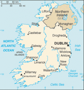
Ireland — Éire in Irish — is an island nation on the western edge of Europe, occupying approximately five-sixths of the island of Ireland in the North Atlantic Ocean. The country borders Northern Ireland (part of the United Kingdom) to the north and northeast across the island’s only land frontier; the Irish Sea and St George’s Channel separate Ireland from Great Britain to the east. With an area of 70,273 km² and a population of approximately 5.1 million, Ireland combines a compact geography with a richly varied landscape of Atlantic coastline, limestone karst, glacial lakes, bogland, and gentle inland hills — all traversed by a well-developed national road and motorway network radiating from Dublin.
Ireland is one of only two EU member states that drive on the left-hand side of the road in right-hand drive vehicles (the other being Cyprus, a legacy of British administration). Speed limits are displayed in kilometres per hour (km/h); distances on road signs are shown in kilometres. The national road network uses an M prefix for motorways, N prefix for national primary and secondary roads, R prefix for regional roads, and L prefix for local roads. Ireland’s motorway infrastructure — centred on the M50 Dublin orbital motorway and a series of intercity motorway corridors — was largely built between 2000 and 2015, funded in part by EU Cohesion and Structural Funds, transforming journey times between Irish cities.
The standard drink-drive limit in Ireland is 0.05% BAC, but a stricter 0.02% BAC limit applies to learner drivers, novice drivers (within two years of first licence), and professional drivers (bus, taxi, heavy goods). Ireland uses the euro (€ / EUR) as its currency. Both the EU emergency number 112 and the traditional Irish emergency number 999 connect callers to An Garda Síochána (police), ambulance, and fire brigade. Notably, Ireland is an EU member but is not part of the Schengen Area — it maintains the Common Travel Area (CTA) with the United Kingdom, which allows passport-free movement between Ireland, Northern Ireland, England, Scotland, and Wales. Use the route planner on our homepage to plan your driving routes across Ireland.
The Irish Road Network
Ireland’s road infrastructure is managed and funded by Transport Infrastructure Ireland (TII), the state agency responsible for the planning, construction, and maintenance of national roads and motorways. Local and regional roads fall under the jurisdiction of local county councils. Ireland’s total road network is approximately 100,000 km; the national road network (M + N prefix) accounts for approximately 5,500 km, of which around 1,100 km are motorway standard. Road signs in Ireland are bilingual — displaying place names in both English and Irish (Gaeilge), with the Irish-language version typically appearing above or below the English. On signposts in Irish-speaking areas (Gaeltacht regions, particularly in Connacht and Donegal), Irish-language names may appear alone.
Ireland’s motorway network is structured as a series of radial corridors emanating from Dublin, with the M50 orbital motorway circling the capital. This radial design reflects Ireland’s geographical and demographic reality: Dublin and its metropolitan area account for approximately one-third of the national population, making the capital the undisputed hub of all major road corridors.
Principal motorways (M-prefix):
- M50 — Dublin Orbital Motorway (~45 km ring): The M50 is Ireland’s busiest road, carrying over 100,000 vehicles per day on its most congested sections. The motorway forms an incomplete western semicircle around Dublin, running from the M1 interchange at Whitehall in the north, through Blanchardstown (M3/M4 junction), Palmerstown, the Red Cow interchange (M7/N7), and Sandyford/Cherrywood in the south, where it terminates near the Luas tram line. The eastern side of the Dublin orbital is completed by the Port Tunnel (M50 spur) and the East Link bridge. The M50 uses Ireland’s eFlow fully electronic barrier-free tolling system (see Tolls section). The Red Cow interchange — connecting the M50 with the M7 (southwest) and N7 — is the most complex junction on the Irish road network and a regular site of congestion, particularly during morning and evening peaks.
- M1 — Dublin–Drogheda–Dundalk–Border with Northern Ireland (~100 km): Ireland’s principal northern motorway, running from Dublin Airport and the M50 junction northward through Drogheda, Dundalk, and to the land border with Northern Ireland near Carrickcarnon, where it connects with the A1 dual carriageway continuing to Newry and Belfast. Journey time Dublin–Belfast (via M1/A1) approximately 1.5–2 hours (165 km total). The M1 is the most important cross-border corridor on the island. Since the Good Friday Agreement of 1998 and post-Brexit arrangements, there are no physical border controls or infrastructure at any crossing point between the Republic and Northern Ireland — traffic flows freely.
- M2 — Dublin–Ashbourne–Navan area (~21 km): Short motorway spur from the M50 (Finglas interchange) northward toward Ashbourne and Navan. The M2 connects to a dual carriageway (N2) continuing toward Monaghan and the border. Journey time Dublin–Navan approximately 40 minutes.
- M3 — Dublin–Clonee–Navan–Virginia–Cavan (~135 km): The M3 runs from the M50 at Clonee northwestward through Navan (the county town of Meath), continues past Kells and Virginia, and terminates south of Cavan town. The M3 opened in stages between 2005 and 2010. It passes near the Hill of Tara (Neolithic monument) and is one of Ireland’s most historically significant motorway corridors. Journey time Dublin–Cavan approximately 75 minutes.
- M4 — Dublin–Maynooth–Enfield–Kinnegad (~80 km, then continues as N4/M6 to Galway): The westward motorway from Dublin, running through County Kildare and County Meath toward the midlands. At Kinnegad, the M4 links to the M6 (toward Galway) and N4 (toward Longford and Sligo). Journey time Dublin to Athlone (via M4/M6, ~130 km) approximately 90 minutes.
- M6 — Kinnegad–Athlone–Ballinasloe–Galway (~120 km): The westward extension of the M4 corridor, running through the midlands to Galway on the Atlantic coast. The M6 is the principal motorway from Dublin to Galway and Connacht. Journey time Dublin–Galway approximately 2.5 hours (220 km). This motorway opened fully in 2009, transforming the Dublin–Galway journey from over 3 hours on the N6 to well under 3 hours.
- M7 — Dublin (Red Cow/M50)–Naas–Newbridge–Portlaoise–Limerick (~165 km): The southwestern motorway, running from the M50 Red Cow interchange through County Kildare (Naas, Newbridge, Athy bypass) and County Laois (Portlaoise, Portarlington), branching south with the M8 at Portlaoise for Cork and continuing west to Limerick. The M7 is the main route from Dublin to Limerick and the south-west. Journey time Dublin–Limerick approximately 2 hours (200 km).
- M8 — Portlaoise–Cashel–Cork (~175 km): Branches south from the M7 at Portlaoise junction and runs through County Tipperary (Cashel, Cahir, Mitchelstown) and County Cork to the Jack Lynch Tunnel approach in Cork city. Together with the M7, this is the main Dublin–Cork corridor. Journey time Dublin–Cork approximately 2.5 hours (255 km total). The M8 passes near the iconic Rock of Cashel.
- M9 — Kilcullen (M7 junction)–Carlow–Knocktopher–Waterford (~100 km): The southeastern motorway from a junction off the M7, running south through County Carlow and County Kilkenny to Waterford city. Journey time Dublin–Waterford approximately 1.5–2 hours (165 km).
- M11 — South Dublin–Bray–Wicklow–Arklow (via N11, ~70 km motorway/dual carriageway): The southeastern corridor toward Wexford and Rosslare Europort. The M11 provides the route to the Rosslare ferry port — the primary port for ferries to Wales (Fishguard, Pembroke) and France (Cherbourg, Roscoff). Journey time Dublin–Rosslare approximately 2 hours (165 km).
- M17/M18 — Galway–Tuam–Gort–Limerick (~100 km): The north–south motorway connecting Galway to the M7 Limerick corridor via Gort and Loughrea. The M18 opened in 2017 and significantly improved connectivity between the two largest western cities. Journey time Galway–Limerick approximately 1 hour (100 km). This motorway also connects to Knock Airport (Ireland West Airport Knock) via the M17/N17 approaching Tuam.
- M20 — Cork–Limerick (under planning/construction as of early 2026): A long-planned motorway linking Cork and Limerick directly (~100 km) through County Cork and County Limerick, bypassing existing N20 route via Mallow. The project is a key Government transport priority; various sections are at planning and early civil works stage. Current journey time Cork–Limerick via N20 is approximately 1.5–2 hours depending on traffic.
National roads (N-prefix): Outside the motorway network, national primary roads (N1–N25 and above) provide important inter-urban connections. The N11 (Dublin–Wexford) serves as the main coastal route south of Dublin before the M11 motorway section ends. The N17 (Galway–Sligo) passes through Tuam and Knock and is the main route to the north-west. The N22 (Cork–Tralee, via Macroom and Killarney) is the gateway to the Ring of Kerry and is a busy, winding route through the Kerry Mountains. The N25 connects Cork to Waterford and Rosslare along the south coast. Road improvement works are ongoing across the national network, with many single-carriageway national primary roads being upgraded to motorway or dual carriageway standard.
Driving Rules and Legal Requirements
Ireland drives on the left-hand side of the road in right-hand drive vehicles. This is the most critical difference for visitors arriving from continental Europe or other right-hand traffic countries. When entering Ireland — whether by ferry or via Northern Ireland from Britain — remember to keep left immediately and consistently. Roundabouts are navigated clockwise; give way to traffic approaching from the right (i.e., to your right as you approach the roundabout, which is already on the roundabout). At junctions, yield to traffic on the right.
Drink-driving limits: The standard limit is 0.05% BAC (50 milligrams of alcohol per 100 millilitres of blood). A reduced limit of 0.02% BAC applies to learner permit holders, novice drivers (those who have held a full licence for less than two years from the date of first obtaining a full licence), and specified professional drivers (bus, taxi/hackney, heavy goods vehicle operators). An Garda Síochána (Gardaí) operate mandatory roadside breath testing checkpoints; under the Road Traffic Act 2010, a Garda may require any driver to take a breath test — there is no requirement for suspicion of alcohol consumption. Refusal to take a breath test is an offence carrying the same penalties as a positive result.
Seat belts: Wearing a seat belt is mandatory for all occupants in all seats. The driver is responsible for ensuring all passengers under 17 are belted. Fines apply.
Child restraints: Children must use an appropriate child restraint system until they reach 135 cm in height or 36 kg in weight (approximately 11–12 years old). Children below 135 cm must use a booster seat or child seat appropriate for their height and weight. Children under 3 years must be in a rear-facing child seat in the back (unless the front airbag is deactivated).
Mobile phones: It is illegal to use a handheld mobile phone while driving in Ireland. This includes texting, calling, and any other interaction with a handheld device. Hands-free systems are permitted. Fixed penalty notices and penalty points apply. Persistent offenders face court prosecution.
Mandatory vehicle equipment: Unlike some EU countries, Ireland does not legally require a warning triangle, first-aid kit, high-visibility vest, or fire extinguisher for ordinary passenger cars — though carrying a warning triangle and a high-visibility vest is strongly recommended for use in the event of a breakdown. Commercial vehicles have different requirements.
Headlights: Headlights are not required during daylight hours in clear conditions under Irish law (Ireland does not have a mandatory daytime running lights law beyond the EU-standard DRL requirement for new vehicles). However, headlights must be used in poor visibility, rain, fog, dusk, and at night. All modern EU-type-approved vehicles have automatic or mandatory daytime running lights (DRL) — these satisfy the requirement.
Overtaking and lane discipline: On Irish roads, drive and overtake on the left. Overtake on the right only. Do not overtake where road markings prohibit it (double white lines, broken centre line adjacent to a solid line). On motorways, the right lane (outside lane) is for overtaking only; do not travel in the right lane unnecessarily — lane hogging is a specific offence under Irish law.
Penalty points system: Ireland operates a penalty points system under the Road Traffic Act. Points are recorded on the driving licence for specified offences (speeding, mobile phone use, seatbelt non-compliance, etc.). Accumulating 12 or more points results in automatic disqualification from driving for 6 months. Foreign licence holders visiting Ireland are not exempt from Irish traffic law; fines are issued directly.
Road signs and markings: Irish road signs follow broadly similar conventions to UK and EU signs but are bilingual. White-on-green signs indicate motorway directions; white-on-blue signs indicate national primary roads; white-on-black or yellow-on-black signs indicate secondary and local roads. Brown signs indicate tourist and heritage sites. On regional roads, destination signs in Irish-speaking (Gaeltacht) areas may appear in Irish only — carrying a map or GPS is essential in these regions.
Speed Limits on Irish Roads
All speed limits in Ireland are in kilometres per hour (km/h). Despite historical British influence, Ireland adopted metric speed limits in 2005, replacing miles per hour. Speed limit signs are circular with a red border. Note that Northern Ireland uses miles per hour (mph) — be alert to the change when crossing the border.
| Road Type | Standard Limit | Notes |
|---|---|---|
| Built-up areas (urban) | 50 km/h | 30 km/h in school zones and shared zones |
| Regional and local roads (R and L prefix) | 80 km/h | Often reduced on narrow or winding roads |
| National roads outside towns (N-prefix) | 100 km/h | May be 80 km/h in reduced sections |
| Motorways (M-prefix) | 120 km/h | 100 km/h for vehicles over 3.5 t; variable message signs may reduce limits |
Speed enforcement: An Garda Síochána enforces speed limits using GoSafe mobile speed camera vans (operated under contract by Applus+), which are deployed at designated safety camera zones — locations are published in advance on the Garda and RSA websites. Fixed speed cameras are also present at a smaller number of locations. Penalty: fixed charge notice (fine) plus penalty points for the relevant speed band. Excessive speeding (substantially above the limit) may result in court prosecution, disqualification, and vehicle seizure.
Special speed limits: Local authorities may set reduced special speed limits (20 km/h or 30 km/h) in specific zones, including town centres, school areas, pedestrian-priority areas, and residential estates. These are indicated by circular signs. The Road Safety Authority (RSA) has been progressively reducing default urban limits in many towns to 30 km/h as part of the Vision Zero road safety programme.
Tolls and the eFlow System
Ireland levies road tolls at a limited number of locations — primarily on the M50 Dublin orbital motorway, several river crossings, and a small number of inter-urban motorway sections. Unlike most Central European countries, Ireland does not use a vignette sticker system; all toll collection is either electronic (barrier-free) or at traditional toll plazas.
eFlow — barrier-free electronic tolling on the M50: The M50 Dublin orbital motorway uses eFlow, Ireland’s fully barrier-free electronic toll system. There are no tollbooths anywhere on the M50; instead, overhead gantries with cameras capture every vehicle’s registration plate as it passes. Drivers who have registered for a tag transponder (an eFlow tag mounted behind the windscreen) are automatically charged at a discounted rate. Drivers without a tag are recorded by camera and must pay online at eflow.ie or by phone within 8 days of travel. Failure to pay results in escalating penalty charges and, ultimately, court prosecution. Toll amounts for Category 1 passenger cars (2026 rates):
| Payment Method | Peak Rate | Off-Peak Rate | Night Rate |
|---|---|---|---|
| eFlow Tag (registered transponder) | €2.30 | €1.90 | €1.40 |
| Video/unregistered (pay within 8 days) | €3.10 | €3.10 | €3.10 |
Peak hours are approximately 07:00–10:00 and 16:00–19:00 on weekdays. Rates are reviewed annually. The eFlow tag can be ordered at eflow.ie and is particularly worthwhile for drivers who use the M50 regularly or for extended stays in the Dublin region. Zero-emission vehicles (ZEVs) receive a discount on M50 tolls.
Other toll locations in Ireland:
- East Link Toll Bridge (Dublin): The East Link bridge crosses the River Liffey near Dublin Port, providing an east Dublin orbital route. Barrier toll; payment by cash, card, or tag. Toll approximately €1.90–€2.20 for Category 1 vehicles.
- M1 Northern Motorway (Dublin Port Tunnel area): The Dublin Port Tunnel (linking the Port to the M1/M50 junction at Whitehall) is free to cars; heavy goods vehicles pay a toll.
- M4 Kilcock–Kinnegad (Meath/Westmeath): Toll plaza on the M4 west of Dublin; approximately €1.80–€2.20 for passenger cars.
- M6 Galway Eastern Bypass: Small toll at the Galway city end of the M6; approximately €1.90 for passenger cars.
- M8 Fermoy–Mitchelstown (Cork/Tipperary): Toll on the M8 in this section; approximately €1.90–€2.20.
- M7/M9 areas (Kildare/Kilkenny): Several toll plazas exist on these motorways; typically €1.80–€2.20.
- Limerick Tunnel (N18): Toll tunnel under the River Shannon at Limerick; approximately €2.00 for passenger cars; eFlow-compatible.
- Jack Lynch Tunnel (Cork, N40): Tunnel under the River Lee in Cork; free of charge to all vehicles.
- Waterford City Bridge (N25): The toll bridge over the River Suir at Waterford; approximately €1.90.
Most Irish toll plazas accept cash (euros) and credit/debit cards; many are also compatible with the eFlow tag. Always carry some euro cash in case card readers are unavailable at older barrier plazas.
Fuel, Electric Vehicles, and Charging
Fuel is widely available throughout Ireland, including in rural areas — though station density drops considerably in the more remote parts of Connacht, west Cork, Donegal, and Kerry. On all motorways, service areas with fuel, food, and facilities are present at regular intervals. On smaller regional and local roads — particularly in the Connemara, west Clare, and west Kerry regions — it is advisable to refuel when passing through larger towns rather than relying on finding an open station in rural areas, especially on Sundays when hours may be shorter.
Fuel types: Unleaded petrol (standard 95 RON — E10 grade, labelled “unleaded” or “E10”), Super/premium unleaded (98 RON — E5 grade, labelled “Super Unleaded” or “E5”), diesel (standard and premium grades), and AdBlue for commercial diesel vehicles. LPG (autogas) is available at a small number of stations — coverage is limited. All Irish fuel prices are displayed in euros per litre; prices broadly track European averages plus Irish excise duty levels.
Electric vehicle (EV) charging: Ireland has one of Europe’s most ambitious EV adoption targets and the charging infrastructure is growing rapidly. The national network is operated primarily by ESB (Electricity Supply Board) under the eCars brand and by a growing number of private operators (Ionity, Applegreen Electric, EasyGo, ChargePoint). Key charging facts for Ireland:
- Fast DC chargers (50–150 kW) are present at motorway service areas on the M1, M4, M6, M7, M8, and M18 corridors and at major retail parks in cities.
- Dublin, Cork, Galway, Limerick, and Waterford all have reasonable urban charging coverage.
- Rural and remote areas (west Kerry, Achill Island, north Donegal) have very limited infrastructure — plan charging stops carefully using the ESB eCars app or PlugShare before venturing into these regions.
- The eFlow M50 toll system offers discounted rates for Battery Electric Vehicles (BEVs) registered on the eFlow system.
Scenic Routes and Long-Distance Driving
Wild Atlantic Way (W470, ~2,500 km): The Wild Atlantic Way is Ireland’s flagship long-distance driving and cycling route, running along the entire Atlantic coastline from Malin Head in County Donegal (the most northerly point of Ireland) southward to Kinsale in County Cork. The route traverses County Donegal, Sligo, Mayo, Galway, Clare, Limerick, Kerry, and Cork, linking dramatic coastal scenery, cliffs, sea inlets (loughs and bays), historic sites, and Atlantic villages. The route is signed with a distinctive wave logo and reference number W470. The full route takes 10–14 days to complete at a leisurely pace; individual sections make excellent day or overnight drives. Notable segments include the Slieve League cliffs in Donegal (among the highest sea cliffs in Europe), the sky road near Clifden in Connemara, and the Cliffs of Moher in County Clare.
Ring of Kerry (N70/R568, ~179 km circuit): One of Ireland’s most celebrated driving routes, the Ring of Kerry is a circular route around the Iveragh Peninsula in County Kerry, running through Killarney, Killorglin, Cahersiveen, Waterville, Kenmare, and back to Killarney. The route passes through spectacular Atlantic coastal scenery and the MacGillycuddy’s Reeks mountain range (home to Carrauntoohil, the highest mountain in Ireland at 1,038 m). The Ring is extremely popular in summer (May–September); coaches operate anticlockwise, and private drivers are encouraged to follow the same direction to avoid head-on situations on narrow sections. Kenmare is a popular base for the Ring. An extension — the Ring of Beara — covers the adjacent Beara Peninsula with fewer crowds.
Dingle Peninsula and Slea Head Drive (R559, ~50 km): The Dingle Peninsula in County Kerry is widely regarded as one of the most beautiful drives in Ireland, featuring views of the Blasket Islands, ancient stone beehive huts (clochán), dramatic sea cliffs, and the bilingual (Gaeltacht) village of Dingle. The Slea Head Drive — a loop from Dingle town — is a half-day circuit suitable for standard passenger cars (not large motorhomes). The Connor Pass (456 m), crossing the central spine of the peninsula, offers panoramic views of Dingle Bay on clear days.
The Burren and Cliffs of Moher (County Clare): The Burren is a unique karst limestone landscape in north County Clare, featuring bare grey pavements, rare flora, and prehistoric megalithic tombs (including the Poulnabrone dolmen). The R480 and R476 roads traverse the Burren interior. The Cliffs of Moher — vertical sea cliffs rising to 214 m above the Atlantic — are Ireland’s most visited natural attraction and are accessed via the R478 from Lahinch or Liscannor. Parking is managed at the main visitor centre; do not park on approach roads.
Connemara (County Galway): The Connemara region west of Galway city is one of the most scenically dramatic parts of Ireland: a wild landscape of bog, granite mountains (the Twelve Bens), sea inlets, and Atlantic islands. The N59 (Galway–Clifden) and R336 (Sky Road, Clifden) are the principal scenic routes. Clifden is the main town; Roundstone, Ballyconneely, and Letterfrack are smaller villages on the loop roads. Many roads in Connemara are narrow single-track roads with passing places — drive slowly and be prepared to reverse.
Causeway Coastal Route (towards Northern Ireland): The route along Ireland’s northeast coast from Dublin via Belfast to the Giant’s Causeway (County Antrim, Northern Ireland) is a popular driving circuit. In the Republic, the N2/M1 runs to the border; in Northern Ireland, the A1/A2 continues to Belfast and the coastal A2 runs north to Antrim. This cross-border drive encompasses the UNESCO World Heritage Site of the Giant’s Causeway — one of the most remarkable geological formations in Europe. See the Northern Ireland section for border-crossing information.
Driving in Dublin, Cork, and Galway
Dublin: Ireland’s capital, with over 1.4 million people in the Greater Dublin Area, is one of the most congested cities in Europe relative to its size. The M50 orbital motorway is the first point of contact for most motorway arrivals and is itself heavily congested — particularly at the Red Cow, Ballymount, and Sandyford interchanges during peak hours (07:00–09:30 and 16:30–19:00 weekdays). In the city centre, the Liffey quays, the Grand Canal ring, and the city grid experience severe congestion daily. The Luas tram network (Red and Green lines) intersects the city centre, and tram tracks on shared roads require extra attention from drivers. Parking in Dublin city centre is expensive (€4–6/hour in city-centre car parks) and heavily regulated; clamping and towing are actively enforced. The Dublin Port Tunnel (free for cars; heaviest HGV toll in Ireland applies) allows through freight traffic to bypass the city centre.
Cork: Ireland’s second city (~230,000 metropolitan area) sits in a river valley; the city centre is built on an island between two channels of the River Lee. City-centre roads are narrow and often congested. The Jack Lynch Tunnel (N40) provides a free river crossing east of the city centre and is the main link between the southern (N28, Ringaskiddy port) and northern (N8, Dublin) approaches. The N40 South Ring Road partially circumvents the city. Cork is the departure point for ferries to the UK (Swansea via Brittany Ferries) and to France (Roscoff, Cherbourg). Journey time Cork–Dublin via M8/M7 approximately 2.5 hours.
Galway: The gateway to the west of Ireland (~90,000 city, ~250,000 county), Galway is the terminus of the M6 from Dublin and the M18 from Limerick. The city centre is compact with pedestrianised streets, and parking is managed via a pay-and-display system. The N59 westward from Galway opens up the Connemara region; the N17 northward leads to Tuam and Mayo. Galway suffers from significant traffic pressure during summer — the N6 approaches and the city ring road can be slow; arrive early in the day for scenic coastal excursions.
Limerick: At the junction of the M7 (Dublin), M18 (Galway), and N20 (Cork), Limerick (~100,000) is a major traffic node in the mid-west. The Limerick Tunnel (N18) beneath the Shannon provides a toll crossing that relieves the city centre of north–south traffic. The city centre itself has been significantly regenerated; the Shannon riverside (Milk Market area) and Thomond Park are popular destinations.
Crossing into Northern Ireland
Northern Ireland is part of the United Kingdom and is a separate legal jurisdiction from the Republic of Ireland — but since the Good Friday Agreement of 1998 and subsequent post-Brexit arrangements under the Windsor Framework, there is no physical border infrastructure between the Republic and Northern Ireland. Roads cross the border at multiple points with no checkpoints, barriers, or passport control. Citizens of Ireland, the UK, and EU member states can cross freely as part of the Common Travel Area (CTA). Non-CTA nationals (e.g., from outside the EU/UK) may in theory need to comply with UK immigration rules when entering Northern Ireland, though in practice there are no checks at road crossings — the border is effectively invisible on the ground.
The key practical differences when entering Northern Ireland from the Republic:
- Speed limits switch from km/h to mph at the border. The standard Northern Ireland limits are 30 mph (48 km/h) in urban areas, 60 mph (96 km/h) on single-carriageway roads, and 70 mph (112 km/h) on dual carriageways and motorways.
- Currency changes from euro (€) to pound sterling (£ / GBP). Most large petrol stations and major tourist sites near the border accept both currencies, but credit/debit card is universal.
- Driving rules are largely identical (left-hand traffic, same road sign conventions under the Vienna system), though some minor differences in signage exist.
- Motorway designations change: Irish M-prefix motorways connect to Northern Irish M-prefix motorways (e.g., Irish M1 → NI A1 → NI M1 toward Belfast).
- No eFlow tolls in Northern Ireland — no motorway tolls exist in Northern Ireland at all.
- Emergency number: In Northern Ireland, both 999 (UK standard) and 112 work. Police in Northern Ireland are the Police Service of Northern Ireland (PSNI).
Main border crossing points (there is no passport control — these are just geographic crossings):
- M1/A1 — Dublin–Belfast (via Carrickcarnon/Newry): Primary motorway corridor; the heaviest-used crossing. Belfast is approximately 165 km from Dublin; journey time 1.5–2 hours.
- N2/A3 — Monaghan–Armagh corridor: Secondary route toward Armagh and Dungannon.
- N54/A3 — Cavan–Enniskillen: Route to Fermanagh and the Upper Lough Erne area.
- N16/A4 — Sligo–Enniskillen: Western crossing through Fermanagh.
- N13/N14 — Donegal to Derry/Londonderry: Multiple minor crossings through Donegal; the N13/N14 to Letterkenny connects to Derry via A2.
Road Safety and Emergency Procedures
Ireland’s road safety record has improved substantially since the 2000s following the introduction of the penalty points system (2002), mandatory breath testing, GoSafe speed camera vans, and the Safety Camera Partnership. The Road Safety Authority (RSA) oversees road safety policy. Fatalities per million inhabitants have fallen significantly from the highs of the 1990s, though Ireland’s rural roads — with livestock crossings, hedgerows that restrict sight lines, and unlit single-carriageway roads — remain a challenge, particularly for visitors unused to narrow Irish country roads.
In an emergency: Call 112 (EU standard) or 999 (traditional Irish number) — both work from any phone, including mobiles with no credit. The operator will connect you to An Garda Síochána (police), Ambulance Service (HSE National Ambulance Service), or Fire Service as required. On motorways, emergency roadside phones are located at regular intervals; these connect directly to the NRA/TII Traffic Management Centre.
Breakdown: If you break down on the M50 or another motorway, turn on hazard lights and move to the hard shoulder. Call your breakdown service — AA Ireland (0818 227 228), RAC Ireland, or your rental car company’s emergency line. Do not stand behind a vehicle on the hard shoulder; exit via the passenger-side door and stand behind the crash barrier where possible. The eFlow control centre monitors M50 cameras and can despatch motorway incident response vehicles.
Weather hazards: Ireland’s Atlantic climate means rain, mist, and low cloud are common year-round. Black ice and hoarfrost can occur from October through March, particularly in elevated areas (Wicklow Mountains, Kerry, Donegal highlands) and on bridges. In severe Atlantic storms (typically November–February), coastal roads — particularly the Wild Atlantic Way and coastal Kerry/Clare roads — can be dangerous due to wave splash, fallen debris, and high winds. Always check Met Éireann (met.ie) weather forecasts before scenic coastal drives.
Rural road hazards: Irish country roads regularly feature livestock on the road (sheep, cattle, horses being moved between fields), hedgerows right to the road edge eliminating sight lines on bends, and road surfaces that can deteriorate quickly after rain. Drive at a speed that allows you to stop within the visible stopping distance. Be especially cautious on L-prefix local roads and unclassified boreens (narrow lanes) which may be just barely wide enough for two cars to pass.
FAQ: Driving in Ireland
Do I need to buy a vignette or toll pass before driving in Ireland?
No vignette system exists in Ireland. The only mandatory advance consideration is the M50 eFlow toll in Dublin — if you travel on the M50, you must pay the toll either via a registered eFlow tag (transponder) or online at eflow.ie within 8 days of travel. There are no booths; payment is automatic for tag holders and retrospective for non-tag drivers. All other Irish toll plazas have booths accepting cash and cards — you can simply pay as you go.
Does Ireland drive on the left or the right?
Ireland drives on the left-hand side of the road in right-hand drive vehicles. This is the same as the United Kingdom, Cyprus, Japan, and Australia — and is the most important fact to remember when arriving from continental Europe. Keep left at all times, including when pulling out of junctions and roundabouts. Roundabouts are navigated clockwise in Ireland; give way to vehicles already on the roundabout (approaching from your right).
Can I use my EU driving licence in Ireland?
Yes. A valid EU/EEA driving licence is fully recognised in Ireland with no restrictions. Drivers from non-EU countries (including the UK post-Brexit, USA, Canada, Australia, etc.) should carry an International Driving Permit (IDP) alongside their national licence. The IDP is not required for UK licence holders driving in Ireland (under the CTA bilateral agreement), though carrying it is recommended for rental car purposes. Holders of a non-EU licence must exchange it for an Irish licence if they become resident in Ireland for more than one year.
Is Ireland in the Schengen Area?
No. Ireland is a member of the European Union but is not part of the Schengen Area. Ireland and the Republic of Cyprus are the only EU member states that opted out of Schengen. Instead, Ireland is part of the Common Travel Area (CTA) with the United Kingdom, which allows passport-free movement between Ireland, Northern Ireland, England, Scotland, and Wales. EU citizens can travel to Ireland using a national ID card or passport; non-EU nationals must follow Irish immigration entry requirements.
What is the drink-drive limit in Ireland?
The standard limit is 0.05% BAC (50 mg per 100 ml of blood). A lower limit of 0.02% BAC applies to learner permit holders, novice drivers (within two years of obtaining a full licence), and professional drivers (bus, taxi, HGV). An Garda Síochána can stop any driver for a roadside breath test — no suspicion of alcohol is required. Refusal to provide a breath sample carries the same penalty as a positive result.
Do speed limits change when crossing into Northern Ireland?
Yes — this is one of the most important border transitions for drivers. The Republic of Ireland uses kilometres per hour (km/h); Northern Ireland uses miles per hour (mph). The transition happens as you cross the border — watch for new speed limit signs. In Northern Ireland: 30 mph urban / 60 mph single carriageway / 70 mph dual carriageway and motorway. On most modern satnav and Google Maps, the speed unit will switch automatically when you cross the border. If driving a car with only a km/h speedometer, 100 km/h ≈ 62 mph (motorway limit).
Are Irish roads suitable for large motorhomes and campervans?
Major national roads, motorways, and national primary routes are fully suitable for large vehicles. However, many of the most scenic routes — the Wild Atlantic Way, Ring of Kerry, Dingle Peninsula, Connemara, and Donegal coast roads — traverse narrow single-track roads, stone-walled lanes, and low bridges that are unsuitable for large motorhomes or campervans. Vehicles over approximately 7 metres in length or 2.3 metres in width should research specific route restrictions before attempting scenic secondary roads. Smaller campervans (up to van-size) are generally suitable for most Routes. Dedicated motorhome route apps and the Irish Motorhome Club provide guidance.
What do I do if I don’t pay an M50 toll in time?
If you travel on the M50 without a registered eFlow tag, your vehicle’s registration plate is captured by camera. You have 8 days from the date of travel to pay the toll online at eflow.ie or by calling the eFlow customer service line. After 8 days, a First Unpaid Toll Notice is issued, adding administrative charges to the original toll amount. Further non-payment results in escalating penalties, court enforcement, and in some cases, vehicle clamping. Rental car companies typically pass M50 toll charges (plus an administration fee) to the renter — check your rental agreement for details.
Sources and Update Note
This Ireland driving guide draws on information from Transport Infrastructure Ireland (TII) (tii.ie), eFlow (eflow.ie) for M50 toll rates, An Garda Síochána (garda.ie) and the Road Safety Authority (RSA) (rsa.ie) for traffic law and enforcement, ESB eCars (esb.ie/ecars) for EV charging infrastructure, Fáilte Ireland (failteireland.ie) for scenic route designations, the Wild Atlantic Way official documentation (wildatlanticway.com), and OpenStreetMap contributor data. Cross-border information draws on the Department of Foreign Affairs (Ireland) and the UK Home Office guidance on the Common Travel Area. Speed limit regulations are sourced from the Road Traffic Act 2004 (as amended) and the Road Traffic (Speed Limit) Regulations 2015 (S.I. No. 3 of 2015).
Irish road infrastructure is actively evolving — the M20 Cork–Limerick motorway and several national road improvement schemes are progressing, and eFlow toll rates are reviewed annually. Verify current eFlow rates at eflow.ie, current road conditions at AA Roadwatch (theaa.ie) or TII, and weather at Met Éireann (met.ie) before travel. This guide reflects information current as of February 2026.