Google Maps™ driving directions home » Gibraltar

Gibraltar

Driving Directions Gibraltar

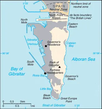
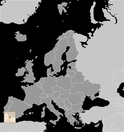
GIBRALTAR, or “The Rock”, is a limestone promontory situated at the end of a peninsula that forms the south­ernmost tip of Spain.

Its strategic importance, guarding as it makes the western approaches to the Mediterranean and separated from Morocco by the narrow Straits of Gibraltar, has meant that it has had a fascinating human history stretching back over thousands of years to Neolithic times.

Read more

Google Maps™ driving directions home » Gibraltar

Gibraltar Google Map

This image shows the draft map of Gibraltar, Europe. For more details of the map of Gibraltar, please see this page below. This image shows the location of Gibraltar, Europe. For more geographical details of Gibraltar, please see this page below. This image shows the flag of Gibraltar, Europe. For more details of the flag of Gibraltar, please see this page below.
Borderline map of Gibraltar Location map of Gibraltar Flag of Gibraltar

Gibraltar Google map

Google Maps and Detailed Facts of Gibraltar (GI). This page lets you explore Gibraltar and its border countries (Country Location: Southwestern Europe, bordering the Strait of Gibraltar, which links the Mediterranean Sea and the North Atlantic Ocean, on the southern coast of Spain) through detailed Satellite imagery – fast and easy as never before Google Maps.

Find comprehensive information about this country’s diversity below: Google maps, geography, economy, science, people, culture, environment, government, and history – All in One Wiki page.

There is also a Street View and free Driving Directions at your service. Your Google Satellite Map Sightseeing in Gibraltar, in Europe, starts here at Driving Directions and Maps.com.

Read more