
Embark on a seamless journey with the JFK AirTrain map, a 2023 guide that unlocks efficient travel to and from John F. Kennedy International Airport! This vital transportation network, operated by the Port Authority of New York and New Jersey, connects the airport’s terminals to Jamaica Station and Howard Beach, serving millions of travelers exploring the USA. Whether you’re a tourist arriving in NYC, a local commuting to Queens, or a map enthusiast intrigued by transit systems, this map simplifies your airport experience. Join us as we trace its routes, explore its features, and discover why the AirTrain is a key to unlocking New York City.
JFK AirTrain Map Description: Decoding a Transit Network
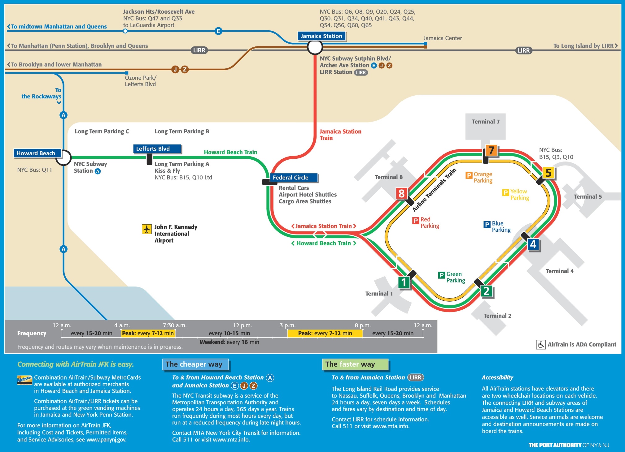
The JFK AirTrain map, updated in 2023, details a circular and linear transit system spanning the airport’s 4,930 acres. The map highlights a red loop connecting Terminals 1 through 8, with stops at each terminal, including Terminal 4 and Terminal 7, marked by colored parking areas (yellow, blue, green, red). Two blue lines extend outward: one to Jamaica Station, linking to the Long Island Rail Road (LIRR) and NYC Subway (E, J, Z lines), and another to Howard Beach, connecting to the A line subway. Green lines indicate rental car shuttles and cargo areas, while a frequency chart shows train intervals, ranging from 12 minutes off-peak to 7-12 minutes during peak hours. The map frames the airport against the backdrop of Queens, with clear access points and accessibility notes.
Purpose of the Map: Streamlining Travel and Accessibility
This map serves as an essential tool for the 62 million annual passengers at JFK, facilitating smooth navigation and transfers. Travelers use it to move between terminals, catch the AirTrain to Jamaica Station for LIRR or subway connections to Manhattan, or reach Howard Beach for Brooklyn and Lower Manhattan access. Airport staff and Port Authority officials rely on it to manage operations, ensure timely service, and maintain ADA compliance with elevators at all stations. Commuters and tourists alike benefit from its guidance, whether renting a car, parking long-term, or planning a trip, making it a cornerstone of airport efficiency and visitor convenience.
Travel Efficiency for Passengers
For passengers, the map directs them from terminal stops to key transit hubs, with clear markers for Jamaica Station (LIRR and subway) and Howard Beach (A line). It highlights parking options and shuttle routes, simplifying luggage transfers or car rentals. The frequency guide aids in timing journeys, ensuring minimal wait times during peak travel periods.
Operational and Accessibility Support
Beyond passenger use, the map supports airport operations by mapping shuttle routes for rental cars and cargo, optimizing logistics. Its 2023 update emphasizes ADA compliance, with elevators and accessibility features at every station, alongside service animal accommodations. This focus ensures inclusivity, making the AirTrain a model for accessible public transit.
Interesting Facts: Uncovering JFK AirTrain’s Vital Role
- Transit Lifeline: Launched in 2003, the AirTrain serves over 6 million riders annually, connecting JFK to NYC’s broader transit network.
- Speedy Service: The Jamaica route takes 20 minutes to Manhattan, while Howard Beach offers a 30-minute trip, beating taxi times during rush hour.
- Terminal Hub: With stops at all eight terminals, it eliminates the need for lengthy walks, covering 8.1 miles of track.
- Eco-Friendly Design: Running on electricity, the AirTrain reduces carbon emissions compared to traditional airport shuttles.
- Historical Context: Built on the site of the former Idlewild Airport, it transformed JFK into a modern travel hub since the 1940s.
The JFK AirTrain map invites you to navigate New York City’s gateway with ease and confidence. Grab this guide, plan your airport transfer, and step into the city’s pulse. Ready to soar into your NYC adventure? The AirTrain awaits to whisk you away!
Discover more USA travel essentials with our expert tips—your next journey starts here!