
Take flight into convenience with the JFK Airport Map, a 2023 guide that simplifies travel through John F. Kennedy International Airport! Serving as a bustling hub for over 62 million passengers annually, this map unlocks the layout of one of the USA’s premier airports, located in Queens, NYC. Whether you’re a traveler arriving from afar, a local heading to a flight, or a map enthusiast intrigued by airport design, this map ensures a smooth journey through terminals, parking, and transit options. Join us as we explore its routes, facilities, and features, discovering why JFK remains a vital entry point to the city.
JFK Airport Map Description: Unraveling a Global Hub
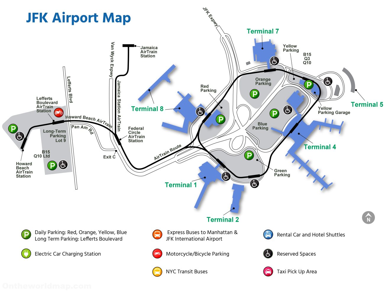
The JFK Airport Map, updated in 2023, details the airport’s expansive 4,930-acre campus with precision. The map centers on a loop of Terminals 1 through 8, each marked in blue, with Terminal 4 and Terminal 7 highlighted as major hubs. Yellow, red, orange, and blue parking areas surround the terminals, including long-term parking at Lefferts Boulevard and daily options near Howard Beach AirTrain Station. Green lines trace the AirTrain route, connecting to Jamaica Station and Howard Beach, with icons for electric car charging stations, motorcycle/bicycle parking, and taxi pick-up zones. Orange lines indicate express buses to Manhattan, while the layout frames the airport against Queens’ urban grid, offering a clear guide to navigation.
Purpose of the Map: Enhancing Travel and Operations
This map serves as an essential tool for the millions navigating JFK Airport each year. Travelers use it to locate their terminal, find parking (daily or long-term), or connect to the AirTrain for subway and LIRR access at Jamaica or Howard Beach. Airport staff and Port Authority officials rely on it to manage traffic flow, coordinate shuttle services, and ensure accessibility with reserved spaces. Rental car agencies and hotel shuttles utilize its layout to guide passengers, while city planners study its design to optimize transportation links. Whether you’re catching a flight, renting a car, or exploring transit options, this map streamlines every step.
Passenger Navigation and Convenience
For passengers, the map directs them to specific terminals, such as Terminal 5 or Terminal 8, with clear markers for parking lots and AirTrain stops. It highlights taxi zones and bus routes, simplifying transfers to Manhattan or beyond. The inclusion of electric charging stations and accessibility features ensures a modern, inclusive travel experience.
Operational and Infrastructure Support
Beyond passenger use, the map supports airport operations by mapping express bus routes and shuttle services for rental cars and hotels. The 2023 update reflects ongoing enhancements, such as expanded parking and improved signage, ensuring efficient logistics. It also aids in managing the airport’s 300+ daily flights, balancing passenger needs with operational demands.
Interesting Facts: Uncovering JFK Airport’s Dynamic History
- Global Gateway: Handling over 62 million passengers yearly, JFK is the busiest international air gateway into North America.
- Historical Roots: Opened in 1948 as Idlewild Airport, it was renamed in 1963 to honor President John F. Kennedy, reflecting its evolution.
- Terminal Diversity: With eight terminals, it serves over 90 airlines, connecting to 150 destinations worldwide.
- AirTrain Advantage: Launched in 2003, the 8.1-mile AirTrain system reduces ground traffic, transporting 6 million riders annually.
- Sustainability Efforts: JFK aims for net-zero emissions by 2050, with electric vehicle charging stations and energy-efficient upgrades.
The JFK Airport Map invites you to navigate New York City’s aerial gateway with ease and confidence. Grab this guide, plan your arrival or departure, and step into the city’s vibrant energy. Ready for takeoff? JFK awaits to welcome you with world-class facilities!
Discover more USA travel essentials with our expert tips—your next airport adventure starts here!