
Imagine a clean, intricate web of red, blue, and green lines stretching across the United States, connecting cities, towns, and landscapes in a dynamic network of travel and commerce, all set against a stark white backdrop. This USA-Interstates-Map reveals the nation’s Interstate Highway System, including two-digit, three-digit, and planned alternate routes, from the bustling I-95 corridor on the East Coast to the scenic I-5 along the West, spanning all 50 states, Alaska, and Hawaii. Whether you’re a road trip enthusiast planning a coast-to-coast adventure, a logistics professional optimizing freight routes, or a geography lover fascinated by America’s infrastructure, this map offers a detailed guide to the highways that drive the nation forward. Let’s embark on a thorough exploration of its routes, uncovering the engineering marvels, historical significance, and practical insights it holds for understanding America’s road network.
USA-Interstates-Map Insights
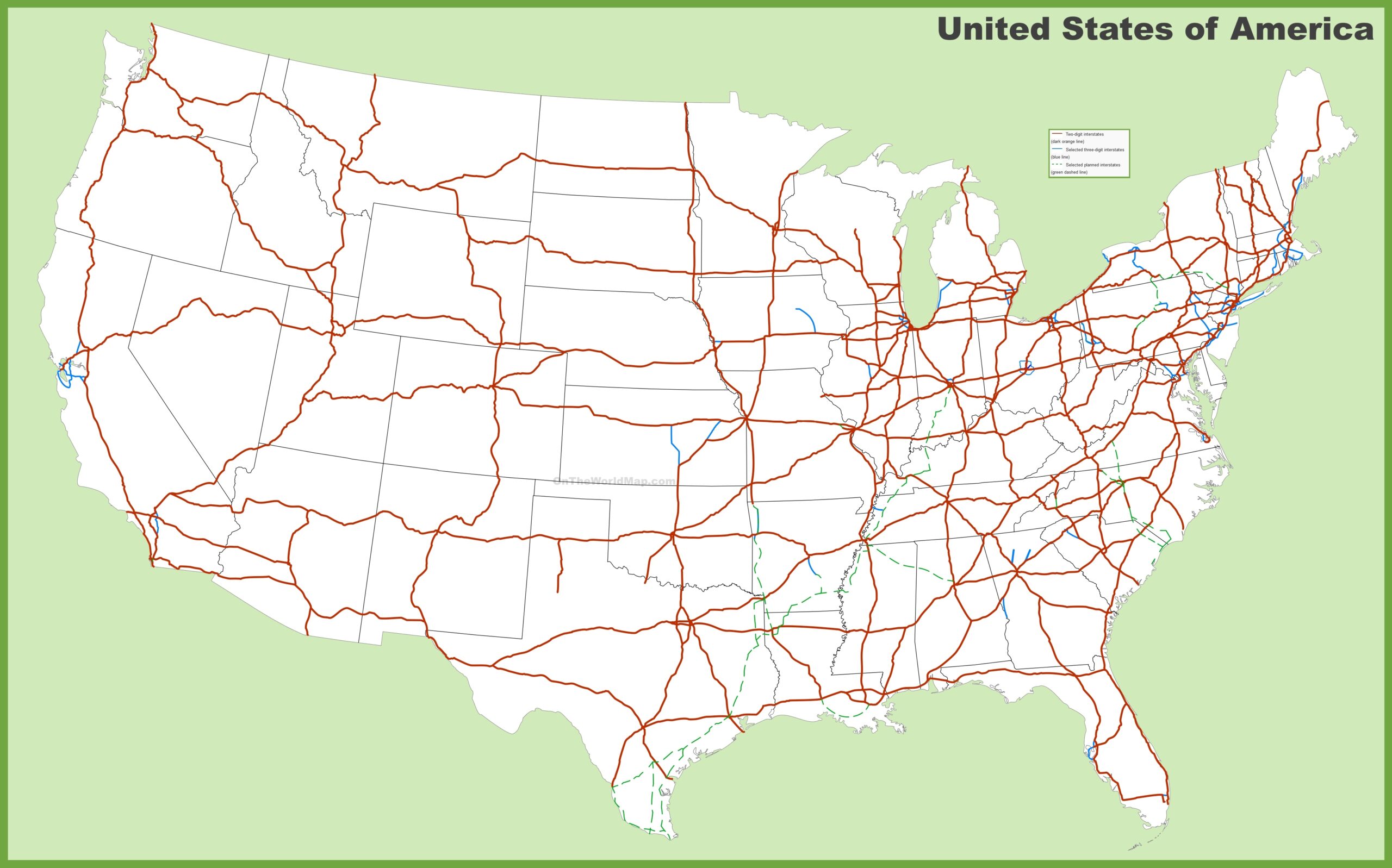
Charting America’s Interstate Lifelines
This precise USA-Interstates-Map showcases the U.S. Interstate Highway System with red lines for two-digit interstates (e.g., I-10, I-80), blue for three-digit interstates (e.g., I-405, I-285), and green for selected planned alternates, stretching from Seattle’s Pacific Northwest to Miami’s sunny shores, with insets for Alaska and Hawaii. It highlights major routes like I-95 along the Eastern Seaboard, I-90 through the Northeast, and I-5 along the West Coast, connecting key cities such as Chicago, Los Angeles, and New York, alongside smaller routes like I-84 in Oregon. The map includes state boundaries and neighboring regions like Canada and Mexico, with a legend clarifying route types, offering a clear tool for navigation, planning, and geographic analysis across America’s vast 3,796,742 square miles.
Boundless Opportunities for Travelers, Businesses, and Planners
Road trippers use this map to plan epic journeys, such as driving from Denver to Atlanta via I-70 and I-75, or exploring scenic detours on I-90 through the Rockies, while truckers optimize routes like I-10 across the South for efficient deliveries. Logistics companies rely on it to chart freight paths, ensuring timely transport from coast to coast, while urban planners assess infrastructure needs for growing interstates like I-95 in the Northeast. Educators teach transportation geography, highlighting the system’s 1956 launch under President Eisenhower, inspired by German autobahns, and emergency services use it for evacuation planning. This map remains a vital resource for anyone navigating or studying America’s highways, fostering travel, economic efficiency, and strategic insight across the nation.
Fascinating Stories of America’s Roadways
Did you know the U.S. Interstate Highway System, signed into law in 1956, spans nearly 48,000 miles and was designed to enhance national defense, commerce, and mobility, drawing inspiration from President Eisenhower’s wartime experiences? This USA-Interstates-Map reflects that legacy, showcasing iconic routes like I-66 through Virginia, I-40 across the Southwest, and I-5 in California, which support over 250 million vehicles daily. States like Texas lead in interstate mileage, while rural areas like North Dakota feature key connectors like I-94, illustrating regional diversity. This map tells a story of engineering innovation, economic growth—think the post-war boom—and cultural shifts, like the rise of road trips on Route 66, each line weaving a narrative of America’s road culture and connectivity across its vast landscape.