
Embark on an exciting adventure with the Brooklyn Map, a guide that unveils the diverse neighborhoods and lively spirit of this 71-square-mile borough in New York City! Home to over 2.6 million residents, Brooklyn stands as a cultural and historic gem within the USA. Whether you’re a traveler eager to explore its parks and waterfronts, a local navigating daily life, or a map enthusiast intrigued by urban diversity, this map invites you to discover its communities. Join us as we navigate its streets, green spaces, and highlights, uncovering the unique character of Brooklyn.
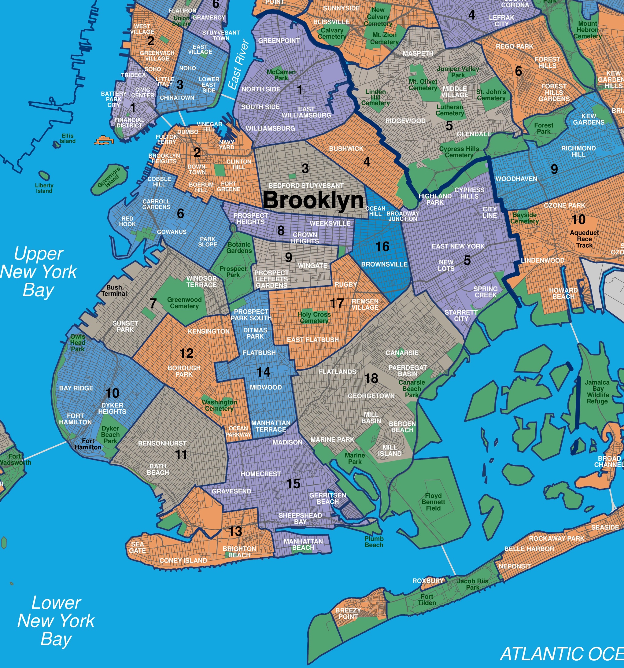
Brooklyn Map Description: Unraveling a Neighborhood Tapestry
The Brooklyn Map details the borough’s expansive coastline along the Atlantic Ocean to the south, the East River to the north, and Upper New York Bay to the west, covering 71 square miles. The map highlights 18 distinct neighborhoods, each color-coded for clarity: Brooklyn Heights (purple), Downtown Brooklyn (gray), Dumbo (purple), Williamsburg (orange), Bedford-Stuyvesant (orange), Crown Heights (orange), Prospect Heights (green), Park Slope (green), Windsor Terrace (green), Kensington (green), Borough Park (orange), Bay Ridge (blue), Bensonhurst (blue), Gravesend (orange), Sheepshead Bay (orange), Brighton Beach (purple), Coney Island (orange), and Rockaway Park (orange). Key features include Prospect Park, the Brooklyn Bridge, and Coney Island Beach, with red lines marking major roads like the Brooklyn-Queens Expressway. The map provides a comprehensive overview of this dynamic borough, set against a backdrop of blue waterways.
Purpose of the Map: Enhancing Exploration and Community Navigation
This map serves as an essential tool for the 2.6 million residents and growing number of visitors to Brooklyn. Tourists use it to locate attractions like the Brooklyn Museum or Coney Island, planning visits to parks and cultural sites. Locals rely on it to navigate to work, shops, or transit hubs like the Atlantic Terminal. City officials and tourism boards leverage its layout to manage infrastructure, promote events, and highlight neighborhood diversity. Whether you’re strolling through Prospect Park, enjoying Coney Island, or exploring history, this map ensures a rich and informed experience.
Visitor Navigation and Cultural Discovery
For visitors, the map directs them to cultural treasures, such as the Brooklyn Botanic Garden in Prospect Heights or the Dumbo waterfront. It highlights major parks like Fort Greene Park and walking routes, making it easy to plan a day of exploration. The inclusion of beaches and ferry access adds variety to the visitor experience.
Community and Urban Planning Support
Beyond tourism, the map supports Brooklyn’s community life by mapping 18 neighborhoods, aiding in urban planning and event coordination. The update reflects ongoing developments, such as enhanced park access and infrastructure improvements, ensuring the map remains a current resource for the borough’s evolving identity.
Interesting Facts: Uncovering Brooklyn’s Rich Heritage
- Cultural Melting Pot: Home to over 100 ethnic groups, Brooklyn is the most diverse county in the USA.
- Park Legacy: Prospect Park, designed by Frederick Law Olmsted, spans 585 acres and attracts 10 million visitors yearly.
- Historic Roots: Settled by the Dutch in 1636 as Breuckelen, it joined NYC in 1898.
- Beach Haven: Coney Island, with its amusement parks since 1829, draws 10 million visitors annually.
- Bridge Icon: The Brooklyn Bridge, opened in 1883, remains a global architectural marvel.
The Brooklyn Map invites you to explore a borough where culture and coastal charm thrive. Grab this guide, plan your visit, and wander through its parks and neighborhoods. Ready to experience NYC’s vibrant sibling? Brooklyn awaits with open arms!
Discover more USA travel treasures with our expert tips—your next neighborhood adventure starts here!