
Step into the vibrant heart of Brooklyn with the Brooklyn Heights, Downtown Brooklyn & Dumbo Map, a guide that unveils the unique charm of these three iconic neighborhoods! Nestled along the East River in New York City, this area attracts locals and visitors with its historic streets, cultural landmarks, and scenic waterfront, all part of the USA’s urban mosaic. Whether you’re a traveler eager to explore historic sites, a foodie seeking local eateries, or a map enthusiast intrigued by Brooklyn’s layout, this map invites you to discover its attractions. Join us as we navigate its parks, dining spots, and highlights, uncovering the dynamic spirit of these neighborhoods.
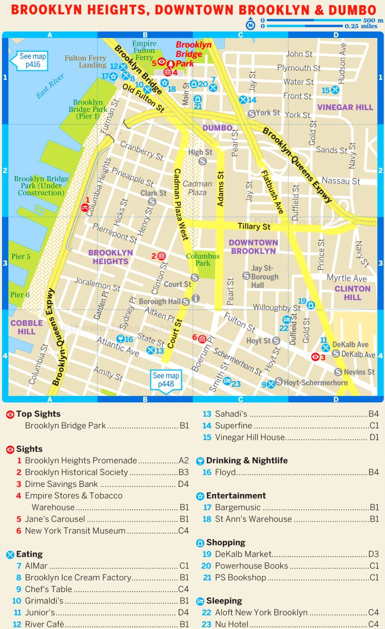
Brooklyn Heights, Downtown Brooklyn & Dumbo Map Description: Unraveling a Waterfront Tapestry
The Brooklyn Heights, Downtown Brooklyn & Dumbo Map details a 1.5-square-mile area along Brooklyn’s East River waterfront, framed by the river to the north and west. The map highlights a grid of streets, with key thoroughfares like Atlantic Avenue and Fulton Street anchoring the layout. Green spaces, such as Brooklyn Bridge Park and Columbus Park, offer urban oases, while orange and yellow markers pinpoint major sights, including the Brooklyn Heights Promenade (2) and the New York Transit Museum (6). Red lines trace major roads like the Brooklyn-Queens Expressway, and numbered spots (1-23) guide visitors to top sights, dining, and entertainment, creating a vibrant guide to this dynamic region.
Purpose of the Map: Enhancing Exploration and Community Engagement
This map serves as an essential tool for the residents and growing number of visitors to Brooklyn Heights, Downtown Brooklyn, and Dumbo. Tourists use it to locate cultural landmarks like the Brooklyn Historical Society (3) or dine at spots like Sahadi’s (13), planning their Brooklyn adventure. Locals rely on it to navigate to parks, shops, or transit hubs like the Hoyt-Schermerhorn station. City officials and tourism boards leverage its layout to manage events, maintain infrastructure, and promote local businesses. Whether you’re strolling along the Promenade, catching a show, or enjoying a meal, this map ensures a rich and informed visit.
Visitor Navigation and Cultural Discovery
For visitors, the map directs them to cultural treasures, with numbered spots leading to Jane’s Carousel (5) or Vinegar Hill House (15). It highlights dining options like AlMar (7) and entertainment venues like Bargemusic (17), making it easy to plan a day of exploration. The inclusion of parks and shopping areas adds variety to the visitor experience.
Community and Local Support
Beyond tourism, the map supports these neighborhoods’ community life by mapping local attractions, aiding in event planning and business promotion. The update reflects ongoing developments, such as new dining spots like Floyd (16) and enhanced park access, ensuring the map remains a current resource for the area’s evolving identity.
Interesting Facts: Uncovering the Neighborhoods’ Rich Heritage
- Historic Heights: Brooklyn Heights, America’s first suburb, features the Promenade (2) with stunning Manhattan views since 1950.
- Cultural Hub: Downtown Brooklyn hosts the New York Transit Museum (6), showcasing subway history since 1976.
- Waterfront Revival: Dumbo, once an industrial zone, now thrives with art galleries and the Jane’s Carousel (5), restored in 2011.
- Architectural Gems: The Williamsburgh Savings Bank Tower (4) stands as a 1929 landmark in Downtown Brooklyn.
- Community Growth: These areas have seen a population surge, with over 200,000 residents, blending historic charm with modern vibrancy.
The Brooklyn Heights, Downtown Brooklyn & Dumbo Map invites you to explore a Brooklyn mosaic where history and culture shine. Grab this guide, plan your visit, and wander through its parks and eateries. Ready to experience Brooklyn’s soul? These neighborhoods await with open arms!
Discover more USA travel treasures with our expert tips—your next neighborhood adventure starts here!