
Imagine a breathtaking panorama of the United States, where towering mountains erupt in shades of brown and gray, lush plains stretch in vibrant greens, and rivers carve intricate paths through the land, all captured in a single, mesmerizing snapshot. This USA-Topographic-Map reveals the nation’s dramatic topography, from the Rocky Mountains in Colorado to the Mississippi River’s winding course through the Midwest, spanning all 50 states, Alaska, and Hawaii. Whether you’re an outdoor adventurer seeking the next peak to conquer, a geologist studying Earth’s formations, a historian tracing America’s natural history, or a planner analyzing its landscapes, this map offers an expansive, detailed guide to the nation’s physical contours. Let’s embark on a thorough exploration of its elevated features, uncovering the geological wonders, regional diversity, and practical insights it holds for understanding America as of 2025!
USA-Topographic-Map Insights
Unveiling America’s Topographic Tapestry
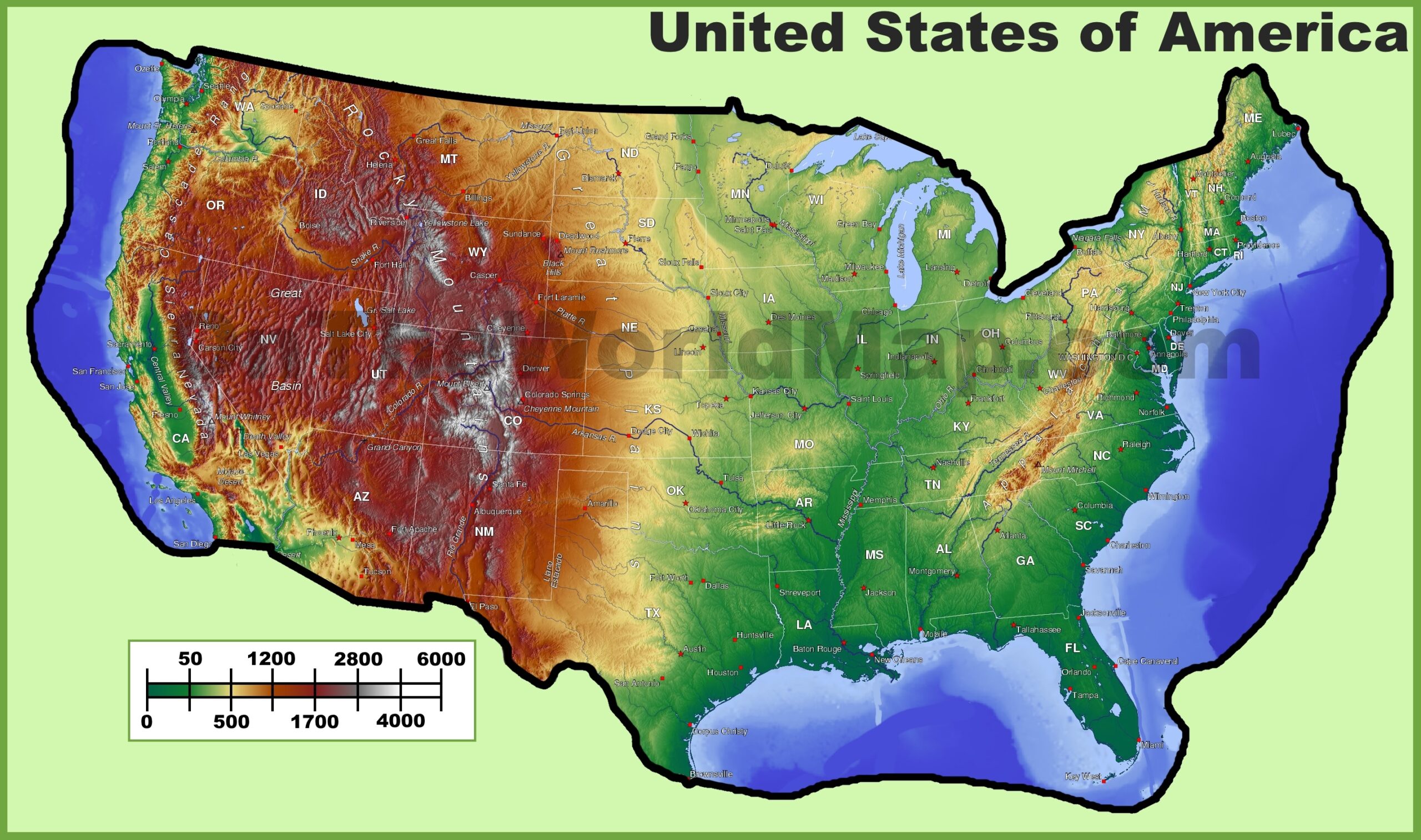
This intricate USA-Topographic-Map showcases the U.S.’s physical landscape with a color-coded elevation scale—green for lowlands (0–500 feet), yellow for rolling hills (500–1,700 feet), orange for higher elevations (1,700–4,000 feet), and brown to gray for mountains (4,000–6,000+ feet)—highlighting features like the Sierra Nevada in California, the Appalachians in the East, and the Great Plains in Kansas. It marks major cities such as Denver, CO, at 5,280 feet, and Los Angeles, CA, at sea level, with red dots for capitals and key locations, and includes rivers like the Colorado, mountain ranges like the Cascades, and bodies of water like the Great Lakes. The map spans from Maine’s coastal lowlands to Hawaii’s volcanic peaks, with insets for Alaska and Hawaii, and shows state boundaries, offering a versatile tool for navigation, education, and geographic analysis across America’s 3,796,742 square miles as of 2025.
Endless Possibilities for Adventurers, Scientists, and Planners
Outdoor enthusiasts and hikers use this map to plan expeditions, targeting peaks like Denali in Alaska (20,310 feet, the highest in North America) or valleys like Death Valley in California (282 feet below sea level, the lowest point), while kayakers navigate rivers like the Mississippi or Colorado. Geologists and environmental scientists analyze it to study tectonic activity, erosion, and climate patterns, while educators teach physical geography, emphasizing elevation changes from the arid Southwest deserts to the forested Northeast. Urban planners and engineers assess terrain for infrastructure projects, such as roads through the Rockies or flood management along the Mississippi, making it an indispensable resource for anyone exploring or studying the U.S., fostering adventure, scientific discovery, and strategic planning across the nation as of 2025.
Captivating Stories of America’s Geological Legacy
Did you know the U.S. boasts some of the world’s most dramatic topography, shaped by millions of years of tectonic shifts, erosion, and glacial activity? This USA-Topographic-Map reflects that legacy, showcasing the Rocky Mountains’ uplift 70 million years ago, the Mississippi River’s 2,300-mile journey formed over millennia, and the Grand Canyon’s 277-mile chasm carved by the Colorado River over 6 million years. States like California feature the San Andreas Fault, while rural areas like Montana highlight vast plateaus, illustrating America’s geological diversity. As of 2025, this map tells a story of natural wonder, human exploration—think Lewis and Clark’s 1804–1806 expedition across the Rockies—and ongoing environmental challenges, each contour weaving a narrative of Earth’s history and America’s enduring connection to its land across its 3,796,742 square miles.