
Hop aboard an exciting rail adventure with the Long Island Rail Road Map, a guide that unveils the extensive network spanning Long Island, New York! This iconic transit system connects over 300,000 daily commuters and visitors to the USA, stretching from Manhattan to the eastern shores of Long Island. Whether you’re a traveler exploring coastal towns, a local navigating daily commutes, or a map enthusiast intrigued by rail systems, this map invites you to discover its routes and destinations. Join us as we trace its lines, stations, and scenic highlights, uncovering the charm of Long Island travel.
Long Island Rail Road Map Description: Unraveling a Regional Network
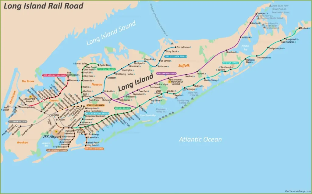
The Long Island Rail Road Map details a sprawling 700-mile network across Long Island’s 1,401 square miles. The map highlights 11 main branches, including the Port Washington Branch (red), Ronkonkoma Branch (purple), and Montauk Branch (green), radiating from Penn Station and Jamaica in Queens. Key stations like Huntington, Babylon, and Montauk dot the coastline, framed by Long Island Sound to the north and the Atlantic Ocean to the south. Green areas mark parks and preserves, while orange lines indicate ferry connections, such as Cross Sound Ferry and Fire Island Ferries. The map uses color-coded routes to guide passengers from urban hubs to coastal gems, offering a clear overview of this vital transit system.
Purpose of the Map: Enhancing Travel and Regional Connectivity
This map serves as an essential tool for the 100 million passengers using the Long Island Rail Road annually. Commuters rely on it to navigate daily trips from Long Island to Manhattan, while tourists use it to explore destinations like Montauk or the Hamptons. Railroad staff and Metropolitan Transportation Authority (MTA) officials utilize its layout to manage schedules, maintain tracks, and ensure service efficiency. City planners and tourism boards leverage it to promote regional travel, connecting urban centers with beach towns. Whether you’re commuting, vacationing, or planning a day trip, this map streamlines every journey.
Passenger Navigation and Exploration
For passengers, the map directs them to major stations like Jamaica or Babylon, with clear markers for ferry links and park access. It supports weekend getaways to seaside villages and daily commutes, offering route options like the Far Rockaway Branch or Oyster Bay Branch, making travel accessible and enjoyable.
Operational and Regional Support
Beyond passenger use, the map supports rail operations by mapping the 11 branches and key junctions, aiding in maintenance and expansion planning. The update reflects ongoing improvements, such as enhanced service to JFK Airport, ensuring the network meets growing demand while connecting Long Island’s diverse communities.
Interesting Facts: Uncovering the Long Island Rail Road’s Rich History
- Historic Network: Founded in 1834, it’s the oldest U.S. railroad still operating under its original name, spanning 700 miles.
- Daily Lifeline: Serving 300,000 daily riders, it’s the busiest commuter railroad in North America.
- Coastal Charm: Routes like the Montauk Branch offer scenic views of the Atlantic, linking to summer hotspots like the Hamptons.
- Ferry Integration: Connections to Cross Sound Ferry and Fire Island Ferries extend travel options to Connecticut and beyond.
- Modern Upgrades: Recent electrification and station renovations improve service, supporting Long Island’s growing population of 2.8 million.
The Long Island Rail Road Map invites you to explore a vital transit lifeline with ease and excitement. Grab this guide, plan your trip, and ride through Long Island’s coastal beauty. Ready to embark? The Long Island Rail Road awaits with endless possibilities!
Discover more USA travel treasures with our expert tips—your next rail adventure starts here!