
Imagine a lush mosaic of green and yellow patches across the United States, where dense forests, sprawling grasslands, and protected lands form a vibrant tapestry of nature’s grandeur, inviting exploration and conservation. This USA-Forests-Map reveals the U.S. Forest Service’s network of national forests, grasslands, and other public lands, from the Pacific Northwest’s towering Douglas firs to the Southern Region’s pine forests, spanning all 50 states, Alaska, and Hawaii. Whether you’re an outdoor enthusiast planning a hiking or camping trip, an environmentalist committed to preserving biodiversity, a historian tracing America’s conservation legacy, or a geography buff fascinated by the nation’s natural resources, this map offers a detailed guide to America’s wild heart. Let’s embark on an expansive journey through its verdant zones, uncovering the ecological wonders, historical significance, and practical insights it holds for understanding America’s public lands as of 2025!
USA-Forests-Map Insights
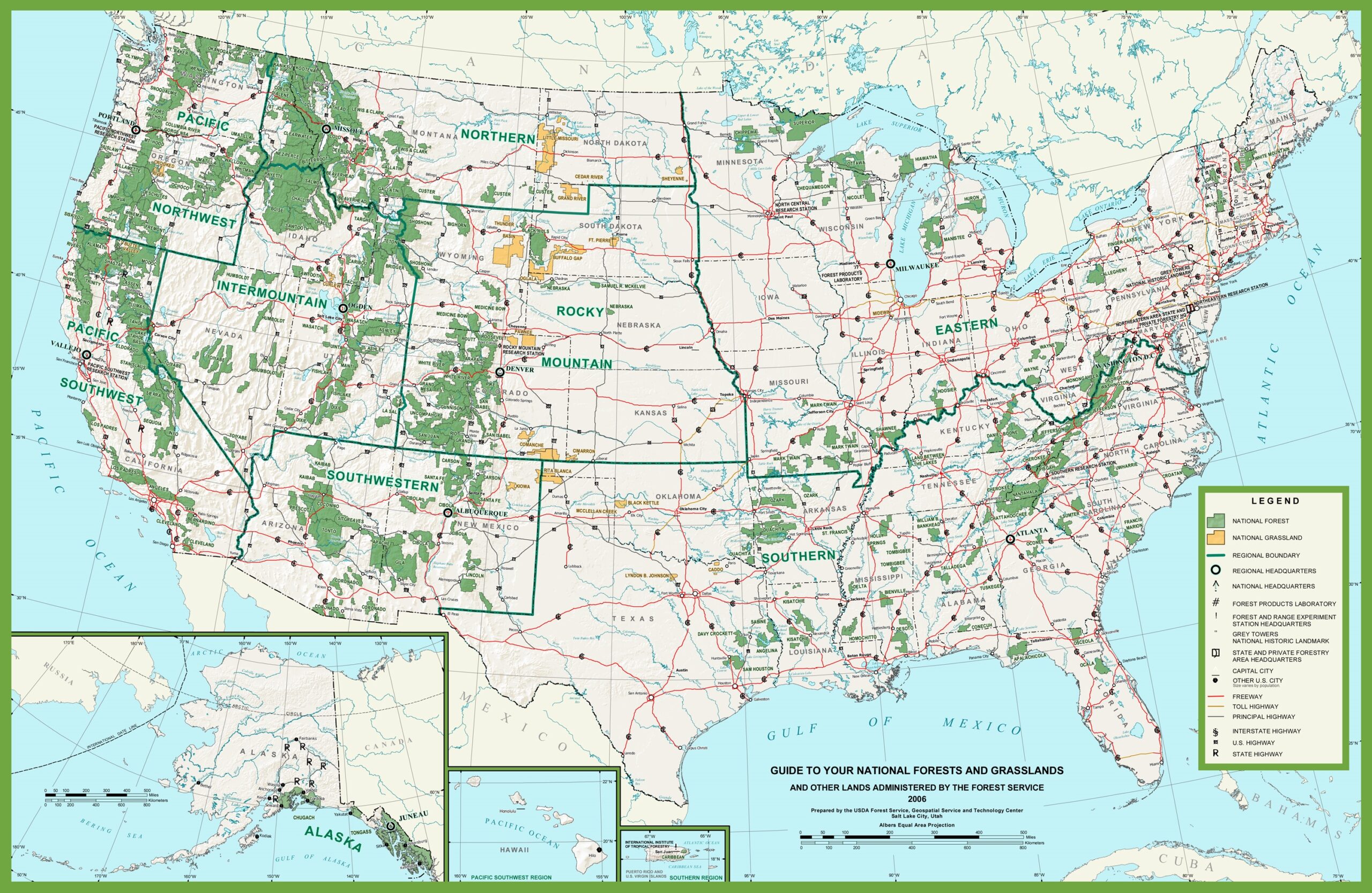
Mapping America’s Natural Treasures
This detailed USA-Forests-Map showcases the U.S. Forest Service’s national forests and grasslands with green for forests, yellow for grasslands, and orange for other lands, set against a light backdrop with state boundaries and major highways. It highlights regions like the Pacific Northwest (e.g., Olympic National Forest in Washington), the Rocky Mountain Region (e.g., White River National Forest in Colorado), and the Southern Region (e.g., Ocala National Forest in Florida), with green outlines marking regional boundaries and symbols for forest headquarters, research stations, and ranger districts. The map spans from Alaska’s Tongass National Forest to Hawaii’s public lands, with insets for Alaska and Hawaii, and includes neighboring regions like Canada and Mexico, offering a comprehensive tool for navigation, education, and environmental analysis across America’s 193 million acres of national forests and grasslands as of 2025.
Boundless Adventures for Nature Lovers, Scientists, and Planners
Outdoor enthusiasts and campers use this map to plan trips, targeting forests like the Apache-Sitgreaves in Arizona for hiking or grasslands like the Little Missouri in North Dakota for wildlife viewing, while anglers fish streams in the Black Hills National Forest in South Dakota. Environmental scientists and conservationists analyze it to study biodiversity, forest health, and climate impacts, such as wildfire risks in California’s Sierra National Forest or restoration efforts in the Ozark-St. Francis National Forest in Arkansas. Educators teach ecology and geography with its depiction of America’s public lands, while urban planners and recreation managers assess access points and infrastructure needs. This map remains a vital resource for anyone exploring or studying the U.S., fostering adventure, scientific discovery, and sustainable planning across the nation’s forests and grasslands as of 2025.
Captivating Stories of America’s Conservation Legacy
Did you know the U.S. Forest Service, established in 1905 under President Theodore Roosevelt, manages 193 million acres of national forests and grasslands to protect resources and promote recreation, building on the 1891 Forest Reserve Act? This USA-Forests-Map reflects that legacy, showcasing the Tongass in Alaska—America’s largest national forest at 16.7 million acres—as a biodiversity hotspot, the Black Forest in Colorado recovering from wildfires, and the Appalachian National Forests in the East, rooted in early conservation efforts. States like Oregon lead in forest coverage, while rural areas like Nebraska highlight grasslands, illustrating regional diversity. As of 2025, this map tells a story of natural wonder, human stewardship—think the Civilian Conservation Corps’ 1930s work—and ongoing challenges like climate change, each green patch weaving a narrative of America’s commitment to its wild lands across its 3,796,742 square miles.