
Embark on a captivating adventure with the Queens Map, a guide that unveils the multicultural landscapes and vibrant communities of this 109-square-mile borough in New York City! Home to over 2.3 million residents, Queens stands as the most ethnically diverse urban area in the world within the USA. Whether you’re a traveler eager to explore its parks and cultural hubs, a local navigating daily life, or a map enthusiast intrigued by urban diversity, this map invites you to discover its neighborhoods. Join us as we navigate its streets, green spaces, and highlights, uncovering the unique spirit of Queens.
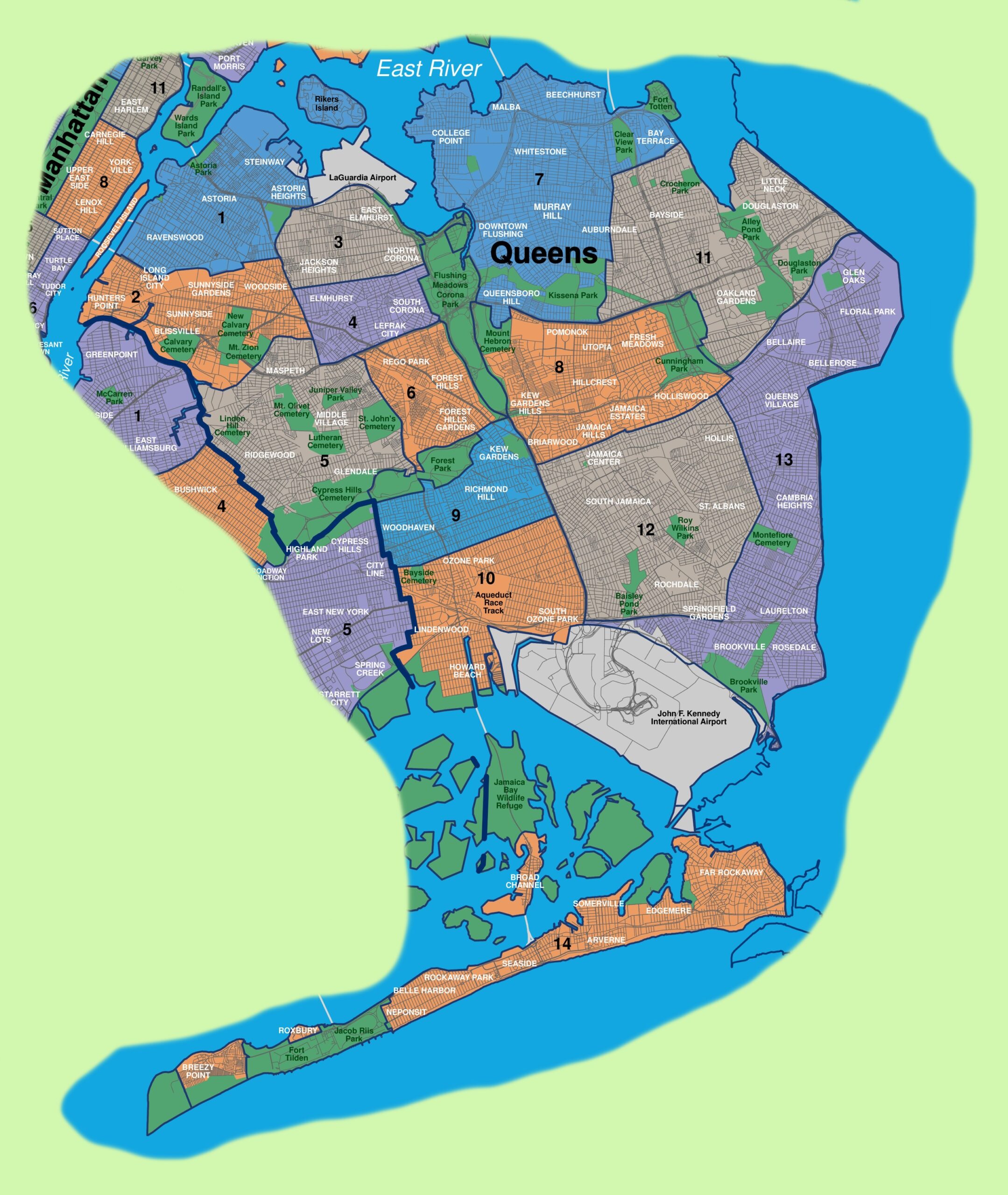
Queens Map Description: Unraveling a Neighborhood Mosaic
The Queens Map details the borough’s expansive layout, stretching from the East River to the Atlantic Ocean, bordered by Long Island Sound to the north and Jamaica Bay to the south. The map highlights 14 distinct neighborhoods, each color-coded for clarity: Astoria (blue), Long Island City (blue), Sunnyside (blue), Woodside (green), Jackson Heights (green), Elmhurst (green), Corona (green), Flushing (green), Forest Hills (orange), Rego Park (orange), Kew Gardens (orange), Richmond Hill (purple), Jamaica (purple), and Far Rockaway (orange). Key features include Flushing Meadows-Corona Park, LaGuardia Airport, and JFK International Airport, with red lines marking major roads like the Long Island Expressway. The map provides a comprehensive overview of this dynamic borough, set against a backdrop of blue waterways.
Purpose of the Map: Enhancing Exploration and Community Navigation
This map serves as an essential tool for the 2.3 million residents and growing number of visitors to Queens. Tourists use it to locate attractions like the Queens Museum or the Unisphere in Flushing Meadows-Corona Park, planning visits to parks and cultural sites. Locals rely on it to navigate to work, shops, or transit hubs like the Jamaica station. City officials and tourism boards leverage its layout to manage infrastructure, promote events, and highlight neighborhood diversity. Whether you’re exploring cultural festivals, relaxing at Rockaway Beach, or flying in via JFK, this map ensures a rich and informed experience.
Visitor Navigation and Cultural Discovery
For visitors, the map directs them to cultural treasures, such as the Louis Armstrong House in Corona or the Noguchi Museum in Long Island City. It highlights major parks like Forest Park and transit options like the 7 train, making it easy to plan a day of exploration. The inclusion of airports and waterfront access adds variety to the visitor experience.
Community and Urban Planning Support
Beyond tourism, the map supports Queens’ community life by mapping 14 neighborhoods, aiding in urban planning and event coordination. The update reflects ongoing developments, such as expanded park access and new transit links, ensuring the map remains a current resource for the borough’s evolving identity.
Interesting Facts: Uncovering Queens’ Rich Heritage
- Cultural Diversity: With over 138 languages spoken, Queens is the most linguistically diverse place on Earth.
- Park Legacy: Flushing Meadows-Corona Park, site of the 1939 and 1964 World’s Fairs, spans 897 acres.
- Aviation Hub: Hosts JFK and LaGuardia airports, handling over 130 million passengers annually.
- Historic Roots: Settled by the Dutch in 1635, Queens joined NYC in 1898.
- Beach Haven: Rockaway Beach, stretching 7 miles, attracts 5 million visitors yearly.
The Queens Map invites you to explore a borough where cultures and nature converge. Grab this guide, plan your visit, and wander through its neighborhoods and parks. Ready to experience NYC’s diverse gem? Queens awaits with open arms!
Discover more USA travel treasures with our expert tips—your next neighborhood adventure starts here!