
Embark on an exciting adventure with the New York City Map, a guide that unveils the diverse landscapes and vibrant communities of this sprawling 300-square-mile metropolis! Home to over 8.4 million residents, New York City encompasses five boroughs—Manhattan, Brooklyn, Queens, the Bronx, and Staten Island—offering a rich cultural mosaic within the USA. Whether you’re a traveler eager to explore iconic landmarks, a local navigating daily life, or a map enthusiast intrigued by urban diversity, this map invites you to discover its neighborhoods and attractions. Join us as we navigate its boroughs, parks, and highlights, uncovering the unique spirit of NYC.
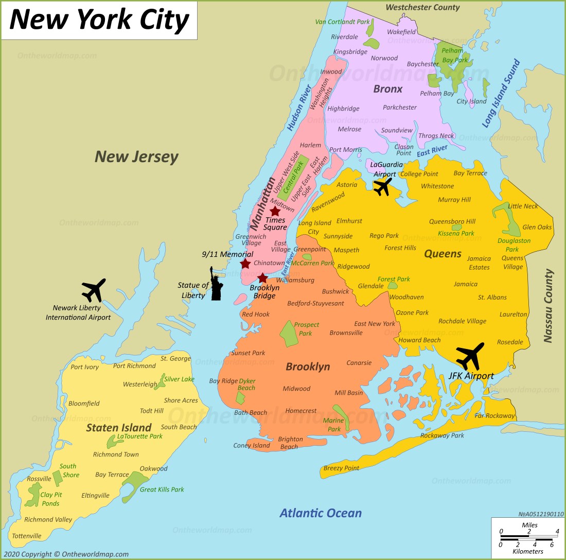
New York City Map Description: Unraveling an Urban Tapestry
The New York City Map details the city’s layout, stretching from the Atlantic Ocean to the south, Long Island Sound to the northeast, and the Hudson River to the west, covering 300 square miles. The map highlights five boroughs: Manhattan (pink), Brooklyn (orange), Queens (yellow), the Bronx (purple), and Staten Island ( peach), each with distinct neighborhoods and landmarks. Key features include Central Park, the Statue of Liberty, and JFK Airport, with red lines marking major roads like the FDR Drive and the Brooklyn-Queens Expressway. Green areas denote parks, such as Prospect Park and Van Cortlandt Park, providing a comprehensive overview of this dynamic city set against blue waterways.
Purpose of the Map: Enhancing Exploration and Community Navigation
This map serves as an essential tool for the 8.4 million residents and millions of annual visitors to New York City. Tourists use it to locate attractions like the 9/11 Memorial in Manhattan or Coney Island in Brooklyn, planning visits to parks and cultural sites. Locals rely on it to navigate to work, shops, or transit hubs like Penn Station and Grand Central Terminal. City officials and tourism boards leverage its layout to manage infrastructure, promote events, and highlight borough diversity. Whether you’re exploring Times Square, relaxing at Jones Beach, or visiting the Bronx Zoo, this map ensures a rich and informed experience.
Visitor Navigation and Cultural Discovery
For visitors, the map directs them to cultural treasures, such as the Metropolitan Museum of Art in Manhattan or Flushing Meadows-Corona Park in Queens. It highlights major airports like JFK and LaGuardia, and ferry routes to Staten Island, making it easy to plan a city-wide adventure. The inclusion of parks and transit options adds variety to the visitor experience.
Community and Urban Planning Support
Beyond tourism, the map supports New York City’s community life by mapping its five boroughs, aiding in urban planning and event coordination. The update reflects ongoing developments, such as new park expansions and improved transportation links, ensuring the map remains a current resource for the city’s evolving identity.
Interesting Facts: Uncovering New York City’s Rich Heritage
- Population Powerhouse: With 8.4 million residents, NYC is the most populous city in the USA, more than 37 states.
- Cultural Diversity: Home to over 800 languages, it’s one of the most linguistically diverse cities globally.
- Landmark Icons: The Statue of Liberty, a gift from France in 1886, welcomed 12 million immigrants.
- Park Legacy: Central Park, opened in 1858, spans 843 acres and attracts over 42 million visitors annually.
- Aviation Hub: JFK and LaGuardia airports handle over 130 million passengers yearly, a global gateway.
The New York City Map invites you to explore a metropolis where culture and innovation thrive. Grab this guide, plan your visit, and wander through its boroughs and landmarks. Ready to experience the Big Apple? New York City awaits with open arms!
Discover more USA travel treasures with our expert tips—your next city adventure starts here!