
Take flight with ease using the LaGuardia Airport Map, a 2023 guide that unveils the layout of one of New York City’s most dynamic airports! Located in Queens, NYC, this hub serves over 30 million passengers annually, acting as a vital domestic gateway to the USA. Whether you’re a traveler arriving from a nearby city, a local heading out, or a map enthusiast intrigued by airport design, this map ensures a smooth journey. Join us as we navigate its terminals, parking, and shuttle routes, discovering why LaGuardia remains a key player in the city’s aviation landscape.
LaGuardia Airport Map Description: Unraveling a Terminal Network
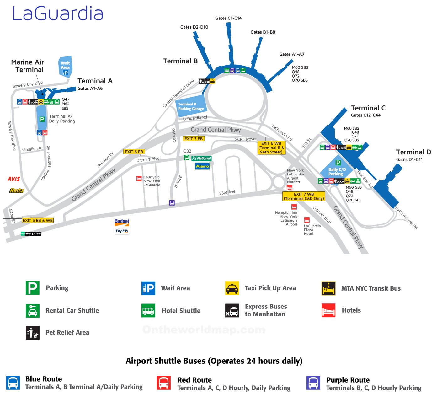
The LaGuardia Airport Map, updated in 2023, details a compact 680-acre layout featuring four terminals: A, B, C, and D. The map highlights Terminal B as the central hub, with gates B1-B8, connected by a circular road network. Terminals A (gates A1-A6), C (gates C1-C14), and D (gates D1-D10) branch off, each marked in blue with orange accents for key areas. Green icons denote parking lots (P1-P6 for daily, with hourly options at Terminals B, C, and D), while red and purple lines trace shuttle bus routes (Red for Terminals A, C, D; Blue for Terminals A, B; Purple for B, C, D). Yellow symbols mark taxi pick-up zones, and black icons indicate MTA NYC Transit buses (M60 SBS, Q48, Q70 SBS), framing the airport against the Grand Central Parkway.
Purpose of the Map: Streamlining Travel and Airport Operations
This map serves as an essential tool for the 30 million passengers navigating LaGuardia each year. Travelers use it to locate their terminal, find parking (daily or hourly), or connect to shuttle buses and MTA transit for Manhattan or other boroughs. Airport staff and Port Authority officials rely on it to manage traffic flow, coordinate shuttle services, and ensure accessibility with reserved spaces. Rental car agencies, hotels, and express bus operators utilize its layout to guide passengers, while city planners study its design to optimize transportation links. Whether you’re parking, catching a shuttle, or boarding, this map enhances every aspect of your journey.
Passenger Navigation and Convenience
For passengers, the map directs them to specific terminals, such as Terminal C or Terminal D, with clear markers for parking lots and shuttle routes. It highlights taxi zones, bus stops, and pet relief areas, simplifying transfers to Manhattan or beyond. The inclusion of wait areas and hotel shuttles ensures a comfortable travel experience.
Operational and Infrastructure Support
Beyond passenger use, the map supports airport operations by mapping express bus routes and 24-hour shuttle services (Red, Blue, Purple). The 2023 update reflects ongoing enhancements, such as expanded parking at P4 and P5, and the integration of MTA buses (M60 SBS, Q48, Q70 SBS), ensuring efficient logistics. It also aids in managing the airport’s 400+ daily flights, balancing passenger needs with operational demands.
Interesting Facts: Uncovering LaGuardia Airport’s Unique Story
- Domestic Powerhouse: Serving over 30 million passengers yearly, LaGuardia is the second-busiest airport in the New York area, focusing on domestic routes.
- Historical Milestone: Opened in 1939 and named after Mayor Fiorello La Guardia, it replaced Floyd Bennett Field, shaping NYC’s aviation history.
- Terminal Revamp: The $8 billion redevelopment, launched in 2016, modernizes Terminals B and C, with completion expected by 2026.
- Proximity Advantage: Just 8 miles from Midtown Manhattan, it offers a 20-minute drive (traffic permitting), ideal for quick city access.
- Sustainability Focus: Recent upgrades include electric vehicle charging and solar panels, aligning with NYC’s green goals.
The LaGuardia Airport Map invites you to navigate NYC’s domestic gateway with confidence and ease. Grab this guide, plan your arrival or departure, and step into the city’s vibrant energy. Ready for takeoff? LaGuardia awaits with top-tier facilities!
Discover more USA travel essentials with our expert tips—your next airport adventure starts here!