
Imagine a colorful canvas of the Northwestern United States, where states like Montana, Idaho, and Washington glow in shades of green, orange, and pink, dotted with red and white circles marking capitals and key cities, inviting you to discover their majestic mountains, lush forests, and scenic rivers. This USA-Northwestern-States-Map reveals the geography of four states—Washington, Oregon, Idaho, and Montana—stretching from the Pacific Ocean’s rugged coast to the Continental Divide, bordered by Canada. Whether you’re a traveler planning a road trip through the Northwest’s wilderness, a historian tracing its pioneering past, a geographer studying its diverse terrain, or an adventurer seeking natural wonders, this map offers a detailed guide to the region’s breathtaking landscapes and cultural gems. Let’s embark on a thorough exploration of its vibrant zones, uncovering the scenic marvels, historical significance, and practical insights it holds for understanding the American Northwest.
USA-Northwestern-States-Map Insights
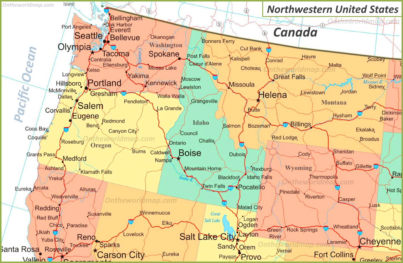
Mapping the Northwest’s Rugged Beauty
This engaging USA-Northwestern-States-Map showcases the four Northwestern states with a palette of pastel colors—light green for Washington, orange for Oregon, light blue for Idaho, and peach for Montana—highlighting capitals like Olympia, WA (red dot), Salem, OR, and Helena, MT, and major cities like Seattle, WA, Boise, ID, and Great Falls, MT. It features state boundaries, major highways like I-90 and I-84, and natural landmarks such as the Cascade Range, Columbia River, and Rocky Mountains, with red dots for capitals and white dots for other cities like Spokane, WA, and Twin Falls, ID. The map spans from Washington’s Pacific coast to Montana’s eastern plains, with connections into Canada, offering a clear tool for navigation, education, and geographic analysis across the Northwest’s 400,000 square miles.
Boundless Adventures for Travelers, Scholars, and Planners
Road trippers and outdoor enthusiasts use this map to plan journeys, driving from Seattle, WA (light green), to Boise, ID (light blue) via I-90 and I-84, or hiking in Montana’s (peach) Glacier National Park and Oregon’s (orange) Mount Hood National Forest, while anglers target Idaho’s (light blue) Snake River or Washington’s (light green) Puget Sound. Historians study it to explore the Northwest’s pioneering history, from the 1805 Lewis and Clark expedition in Montana (peach) to the 1859 Oregon Trail settlement in Oregon (orange), while geographers analyze its varied climates—rainy coasts in Washington (light green), volcanic landscapes in Oregon (orange), and alpine ranges in Idaho (light blue). Urban planners assess growth in cities like Portland, OR (orange), and environmentalists plan conservation efforts in the Cascades, making this map a vital resource for anyone exploring or studying the Northwest, fostering travel, historical insight, and strategic planning across the region.
Captivating Stories of the Northwest’s Legacy
Did you know the Northwestern U.S. shaped America’s identity through exploration, logging, and Native heritage, with Oregon (orange) becoming the 33rd state in 1859 via the Oregon Trail, and Montana (peach) gaining statehood in 1889 amid mining booms? This USA-Northwestern-States-Map reflects that legacy, showcasing Washington’s (light green) Puget Sound ports, Idaho’s (light blue) gold mining towns, and Montana’s (peach) ranch lands, each state rich with cultural icons—lumberjacks in Oregon (orange), Native art in Idaho (light blue), and ski resorts in Washington (light green). The Northwest’s dense forests, from Oregon’s (orange) Willamette Valley to Idaho’s (light blue) Sawtooth Range, contrast with urban hubs like Seattle, WA (light green), illustrating regional diversity. This map tells a story of frontier spirit, natural wonder—think Yellowstone’s geysers in Montana (peach)—and modern innovation, each color weaving a narrative of the Northwest’s past, present, and future across its expansive landscape.