
Driving Directions and Google Map of Andorra — Mountain Roads, Port d’Envalira & Navigation Guide

Andorra is one of Europe’s most extraordinary driving destinations — a tiny sovereign principality of just 468 km² tucked into the heart of the Pyrenees between France and Spain, where every road is a mountain road and every journey unfolds against a backdrop of dramatic peaks rising above 2,900 metres. Despite its miniature size, Andorra punches well above its weight as a driving destination: its roads are among the most spectacular in Europe, its duty-free fuel prices draw visitors from both neighbouring countries, and the combination of world-class ski resorts, tax-free shopping in Andorra la Vella, and jaw-dropping high-altitude scenery makes it a compelling stop on any trans-Pyrenean road trip. Use our free driving directions and Google Map below to plan any route through the principality — from the French border at Pas de la Casa over the highest paved road in the Pyrenees to the Spanish border above La Seu d’Urgell.
Andorra drives on the right side of the road, using left-hand drive vehicles — consistent with both France and Spain. The standard urban speed limit is 40 km/h and the open road limit 90 km/h; there are no motorways within Andorra. The legal BAC limit is 0.05% for ordinary drivers, reduced to 0.03% for new drivers and professional drivers. There are no toll roads within Andorra itself and no road vignette required; note however that the French autoroutes approaching from the north charge tolls on the French side of the border. Duty-free fuel is one of the principality’s most popular draws — petrol and diesel prices are significantly lower than in France and Spain, making it worthwhile to fill your tank fully before re-entering either country.
Road Network Overview
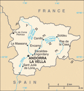
Andorra’s road network is compact but well-maintained — a necessity in a country where every single road must negotiate Pyrenean terrain. The total network extends to approximately 320 kilometres of paved road, all of it at altitude. There are no motorways within the principality, no railways, and no domestic airport — the only way in or out of Andorra is by road, through one of two border crossings: the northern border with France at Pas de la Casa (1,931 m) and the southern border with Spain at Sant Julià de Lòria / La Farga de Moles (950 m), where the road descends to La Seu d’Urgell in Catalonia.
The road system is organised around a small number of Carreteres Generals (CG) — general highways — and Carreteres de Parròquia (CS) — parish roads. The principal artery is the CG1, which forms the spine of the entire country: it enters from Spain in the south at Sant Julià de Lòria, runs northward through Andorra la Vella (the capital), Escaldes-Engordany, Encamp, Canillo, and then continues east past the Grandvalira ski resort toward Pas de la Casa and the French border. This single corridor handles the vast majority of all traffic in Andorra and can become heavily congested — particularly through the capital and the Encamp–Canillo section on ski weekends and summer shopping days.
The CG2 branches east from Andorra la Vella toward Escaldes-Engordany and serves as an alternative to the CG1 for traffic within the urban agglomeration. The CG3 heads northwest from Andorra la Vella into the Valira del Nord valley, serving the parishes of La Massana and Ordino and providing access to the Vallnord-Pal Arinsal ski resort and the northern mountain areas including the Tristaina lakes cirque and the border with Spain’s Val d’Aran at the Coll de la Botella mountain track (accessible only on foot or by 4WD in summer, not a regular road crossing). The CS roads fan out from the main CG arteries into individual valleys and villages, and many of these become unpaved gravel tracks above the treeline — suitable for high-clearance vehicles only and impassable in winter.
Despite its small size, driving through Andorra from border to border — France to Spain via Andorra la Vella — takes approximately 45 minutes to 1.5 hours depending on traffic through the capital. On peak ski weekends (January–February) and major shopping days (weekends around Christmas and Easter), the transit through Andorra la Vella can take considerably longer, as the narrow CG1 through the commercial district of the capital is reduced to a single lane in each direction with no bypass available. The Andorran government has been planning a bypass tunnel under the capital for many years; as of 2025 construction is advanced on the southern bypass section.
Speed Limits
Speed limits in Andorra are set by the Codi de Circulació d’Andorra (Andorran Highway Code) and enforced by the Cos de Policia d’Andorra. They are lower than the limits in neighbouring France and Spain, reflecting the predominantly urban and mountain character of Andorran roads. Fixed speed cameras operate on the main CG1 corridor through Andorra la Vella, Escaldes-Engordany, and on the approach to Pas de la Casa.
| Road type | Speed limit | Notes |
|---|---|---|
| Urban / built-up area | 40 km/h | All towns and villages; strictly enforced through Andorra la Vella; 30 km/h in pedestrian zones and near schools |
| Open road / mountain road | 90 km/h | Maximum outside built-up areas; in practice mountain curves, bends, and gradient reduce safe speed well below this |
| Tunnel (Envalira Tunnel) | 60 km/h | 2.9 km tunnel beneath the Port d’Envalira; speed limit posted inside tunnel; headlights mandatory |
| School zone / pedestrian area | 30 km/h | Common in the capitals’ shopping districts; speed bumps and narrowings frequently encountered |
The lower urban limit of 40 km/h (rather than the 50 km/h common in France and Spain) applies throughout Andorran towns and villages, including the entire commercial strip of Andorra la Vella and Escaldes-Engordany along the CG1. Speed cameras on this corridor are active and fines are applied rigorously — particularly in the pedestrianised shopping zones where the limit can drop to 30 km/h. Outside the towns, the 90 km/h national limit theoretically applies on the CG roads, but the hairpin bends, altitude, and frequently adverse weather conditions (fog, ice, snow, rockfall) mean that sensible driving speeds rarely approach the maximum on mountain sections.
Tolls & Vignette
There are no toll roads within Andorra and no road vignette is required to drive in the principality. All Andorran roads — including the main CG arteries and the Envalira Tunnel — are free of charge. This is in marked contrast to both neighbouring countries: France charges significant tolls on its autoroutes, and Spain has tolls on many of its autopistas (though Spain has been progressively abolishing motorway tolls on some routes).
Drivers arriving from France should be aware that the French side of the route typically involves toll charges on the autoroute network. The most common approach from France is via the A9 / A75 autoroute from Montpellier or via the N20 national road from Toulouse through Foix and L’Hospitalet-près-l’Andorre — the N20 is toll-free south of Pamiers, making it the preferred route for many Andorra-bound travellers from central France. Once at the French border at Pas de la Casa (entering Andorra from France), no toll or vignette applies on the Andorran side.
The Envalira Tunnel (Túnel d’Envalira) — the 2.9 km tunnel beneath the Port d’Envalira summit, which serves as an all-year-round alternative to the mountain pass road when conditions make the high road impassable — is free of charge. The tunnel opened in 2002 and was a significant infrastructure investment for Andorra, ensuring reliable year-round connectivity even during the heaviest winter snowfall. When the tunnel is closed for maintenance, the alternate route over the Port d’Envalira itself (2,408 m) is used — subject to weather conditions and seasonal closure.
Road Rules & Licences
Driving Licence & IDP
EU and EEA member state driving licences are fully recognised in Andorra without an IDP. Visitors holding licences from non-EU countries — including the United Kingdom, United States, Australia, Canada, and other non-EEA nations — are advised to carry an International Driving Permit (IDP) alongside their home-country licence, although enforcement is less rigorous here than in some countries. Andorra is not part of the EU and is not formally bound by EU driving licence mutual recognition rules for non-EEA visitors, though in practice EU-format licences (including the UK’s post-Brexit pink credit-card licence) are accepted by rental companies and authorities without question. The minimum legal driving age in Andorra is 18.
Car hire is available in Andorra la Vella and Escaldes-Engordany from international and local companies. Given the predominantly mountain terrain, many visitors opt for an SUV or AWD vehicle for winter visits. Rental companies operating in Andorra typically allow their vehicles to be driven into both France and Spain, which is convenient for day trips or onward travel; confirm this permission in writing when picking up the vehicle.
Blood Alcohol Limit (BAC)
The legal BAC limit in Andorra for ordinary drivers is 0.05% — the same as in Spain and consistent with the majority of European countries. For new drivers (within two years of first licence issue) and professional drivers (taxis, minibuses, coaches, and heavy goods vehicles), the limit is the stricter 0.03%. The Cos de Policia conducts breath-testing operations, particularly on the main CG1 corridor after peak shopping and leisure periods and during ski season weekends. Fines for exceeding the BAC limit can result in immediate licence suspension and a fine proportional to the level of alcohol detected. As in all mountain driving situations, alcohol consumption before driving at altitude — where cognitive and physical impairment can be more pronounced — is strongly inadvisable.
Key Road Rules
- Seatbelts: Compulsory for driver and all passengers, front and rear. Child seats are mandatory for children under 12 or under 135 cm in height.
- Mobile phones: Handheld use while driving is prohibited. Hands-free kits are permitted. Fines are applied and enforced regularly by the Cos de Policia.
- Warning triangle & reflective vest: Compulsory to carry in the vehicle. The reflective vest must be worn before exiting the vehicle on any road in the event of a breakdown or emergency stop.
- Snow chains: Mandatory when road conditions require them — indicated by the mandatory snow chains sign (a tyre with chains). This sign is regularly displayed on mountain approaches in winter (December–April). Alternatively, winter tyres approved to European M+S or Alpine snowflake standard may substitute for chains in some conditions; confirm locally. Given the high-altitude mountain environment, snow chains or all-season/winter tyres are highly recommended for any winter visit to Andorra.
- Headlights: Must be used when passing through tunnels (including the Envalira Tunnel) and in conditions of reduced visibility (fog, snowfall, heavy rain). Daytime running lights are standard on most modern vehicles and are recommended in all conditions on mountain roads.
- Priority to the right: At uncontrolled intersections, priority belongs to the vehicle approaching from the right — the règle de la droite (priorité à droite) applies in Andorra as in France. On mountain roads, the vehicle ascending generally has priority over the vehicle descending, though this convention is not always observed.
- Horn use: On mountain roads with blind curves and limited visibility, sounding the horn before corners is both legal and advisable on the narrower parish roads (CS routes), where two vehicles cannot pass without one pulling to the verge.
- Parking: In Andorra la Vella and Escaldes-Engordany, parking is controlled — blue zone areas require payment at meters or display of a parking disc. Multi-storey car parks are available throughout the capital. During ski season and peak shopping weekends, car parks fill quickly; allow extra time.
Fuel — Duty-Free Prices
One of the most compelling practical reasons to drive through Andorra is the duty-free fuel. Because Andorra is not a member of the European Union and does not apply EU fuel excise duties, petrol (benzina) and diesel (gasoil) prices in Andorra are consistently and significantly cheaper than in France and Spain — typically by 15–25%, though the differential fluctuates with international crude prices and exchange rates. This price gap is large enough to make it economically worthwhile for drivers from both neighbouring countries to detour specifically to Andorra to fill their tanks, and the row of large petrol stations at the Spanish border in Sant Julià de Lòria and throughout Andorra la Vella is a consistent feature of the driving landscape.
The most common fuel grades available are Benzina 95 (RON 95 unleaded petrol) and Benzina 98 (RON 98 premium unleaded), along with Gasoil (diesel) in standard and premium grades. LPG (autogàs) is available at a small number of stations. There are no EV fast-charging stations throughout the principality as of early 2025, though this infrastructure is expected to develop as EV penetration increases. The main fuel station operators in Andorra include Gesa-Enher (the national energy company), Petroland, and various international brands. Stations are clustered along the CG1 through the capital and near the Spanish and French borders. On the French side of the Pas de la Casa border, and on the Spanish side near Sant Julià, Andorran-priced fuel stations are the first thing many cross-border drivers pull into.
Andorra imposes a fuel purchase quota per vehicle per visit to prevent bulk commercial fuel export — the limit is typically around 40 litres per vehicle per day for private cars. This is enforced by honour system rather than actively at the pump, but the quota should be observed. The quota applies to fill-your-tank purchases, not to jerry cans or bulk containers, which cannot be legally transported across either the French or Spanish border in significant quantities for commercial purposes.
Driving in Andorra la Vella
Andorra la Vella is, at 1,023 m above sea level, one of Europe’s highest capital cities — a distinction it shares with only Madrid and a handful of others. The city and its conjoined neighbour Escaldes-Engordany form the commercial heart of the principality: the wide shopping avenues of Avinguda Meritxell and its surrounding streets are lined with electronics stores, perfumeries, tobacco shops, fashion boutiques, and duty-free alcohol retailers, drawing a steady stream of visitors from across both neighbouring countries throughout the year. The result is a town that, despite its small size and mountain setting, experiences levels of road traffic that belie its modest population.
The CG1 passes directly through the commercial centre, and this section of road — particularly the stretch from the Rotonda de la Constitució (Constitution Roundabout) to the Pont de la Margineda bridge at the city’s western edge — is the single most congested point in the entire country. During winter ski weekends and summer shopping weekends, traffic on this corridor moves at walking pace for extended periods. The Andorran government’s proposed bypass tunnel (Túnel Central d’Andorra la Vella) will eventually provide an under-city route for through-traffic not stopping in the capital, but until this project is complete, patience is essential when transiting the capital during peak times.
For visitors exploring the capital on foot — as most shopping visitors do — the recommended approach is to park in one of the large multi-storey car parks near the commercial district (the Parking del Comú de Andorra la Vella and several private operators are well signposted from the CG1) and continue on foot along Avinguda Meritxell and into the Barri Antic (Old Town). The Barri Antic — the historic medieval core of the capital around the Casa de la Vall, Andorra’s historic parliament building, and the Església de Sant Esteve — is largely pedestrianised and easily explored in a couple of hours. The walk from the parking areas to the old town and back, passing through the duty-free shopping strip, is the standard Andorra la Vella experience.
The French Border — Port d’Envalira & Pas de la Casa
The road to France — the CG2 / CG1 northeast from Andorra la Vella through Encamp, Canillo, and Soldeu to Pas de la Casa — is one of the most dramatic drives in the Pyrenees. The road climbs continuously from the capital at 1,023 m to the Port d’Envalira summit at 2,408 m — the highest paved road pass in the Pyrenees and one of the highest paved roads in Europe. The total distance from Andorra la Vella to the French border is approximately 30 km, and the drive takes 35–50 minutes depending on conditions and traffic.
The ski resort village of Soldeu and the larger resort area of El Tarter are both on this corridor, and in winter the road is extremely busy with ski traffic heading to and from the Grandvalira ski domain — the largest ski area in the Pyrenees, with over 200 km of pistes spread across the slopes above Soldeu, El Tarter, Canillo, and Encamp. Above Soldeu, the road hairpins steeply upward through boulder fields and ski piste crossings to the pass summit and the resort town of Pas de la Casa (1,931 m) — a dense collection of ski apartments, duty-free shops, restaurants, and the French customs post. The French side of the border descends via the N22 to L’Hospitalet-près-l’Andorre and the Ariège valley, joining the N20 toward Ax-les-Thermes, Foix, and ultimately Toulouse or the A9 Mediterranean motorway.
The Envalira Tunnel (Túnel d’Envalira) provides an all-weather alternative to the summit pass. The 2.9 km tunnel branches off from the main road below the pass summit and bypasses the highest section, rejoining the road at Pas de la Casa. The tunnel is free of charge and reduces the risk of being caught out by sudden weather changes — the Port d’Envalira summit can experience severe snowstorms even in late spring and early autumn. When the pass road itself is closed due to extreme weather or heavy snowfall, the tunnel generally remains open. Both roads are subject to closure in truly exceptional conditions; check Andorran road conditions at www.mobilitat.ad before crossing in winter.
The Spanish Border — Sant Julià de Lòria & La Seu d’Urgell
The southern route — from Andorra la Vella south on the CG1 through Sant Julià de Lòria to the Spanish border at La Farga de Moles — is the gentler and more consistently accessible of Andorra’s two border routes. The road descends from the capital at 1,023 m to the border at approximately 820 m over a distance of around 10 km, following the Valira River valley through the urban parishes of Sant Julià de Lòria, with its clusters of large fuel stations, tobacco shops, and supermarkets lining both sides of the road for visitors stocking up on duty-free goods before re-entering Spain.
Across the border, the road immediately becomes Spain’s N-145 national road, which follows the Segre River valley northward through the city of La Seu d’Urgell — the historic seat of the Bishop of Urgell, one of Andorra’s two Co-Princes — before connecting to the C-14 and ultimately to the AP-2 motorway to Barcelona (approximately 200 km and 2.5 hours) or the C-16 (Túnel del Cadí / Cadí Tunnel) as the faster route to Barcelona from the Lleida foothills. The Spanish approach road is generally well-maintained two-lane asphalt with no significant gradients on the lower section, making it the preferred route for heavy vehicles and in winter conditions when the Port d’Envalira may be restricted.
For visitors arriving from Barcelona and the Catalan coast, the C-16 motorway to Berga and then the C-16 tunnel route via Bagà and the Túnel del Cadí (a toll tunnel through the Cadí mountain at 1,200 m — approximately €12 for a car) is both the fastest and most comfortable approach, arriving in La Seu d’Urgell in approximately 2 hours from Barcelona and then crossing into Andorra via the N-145 / CG1. The alternative via Lleida and the Noguera Pallaresa valleys is more scenic but takes considerably longer.
Ski Resorts & Winter Driving
Winter driving is a core part of the Andorran road experience, as a large proportion of the principality’s visitors arrive specifically for skiing at Grandvalira and Vallnord-Pal Arinsal — two world-class ski domains that between them cover more than 300 km of ski runs and are served by modern lift systems, five-star hotels, and resort villages at altitude. The ski season typically runs from late November or early December to late April, and during peak weeks (Christmas, New Year, February half-term, Easter) the roads into and through Andorra can be extremely busy with ski traffic from France and Spain.
Grandvalira is accessed primarily from the CG2/CG1 east of Andorra la Vella — the resort villages of Soldeu, El Tarter, and Canillo are all on the main road, with piste access directly from the roadside at several points. Pas de la Casa, at the French border, is also part of the Grandvalira domain and is the preferred entry point for skiers arriving from France. Vallnord-Pal Arinsal is accessed via the CG3 north from Andorra la Vella to La Massana and then upward through the Arinsal valley — a narrower, steeper approach that requires extra caution and is subject to snow chain requirements more frequently than the main CG1.
Winter driving preparations for any visit to Andorra between November and April should include: winter tyres or all-season M+S tyres as a minimum; snow chains in the boot as a precaution even if winter tyres are fitted (mandatory when signs require them); a full tank of fuel before the mountain section; a charged mobile phone; and awareness of the Andorran road conditions website (mobilitat.ad) and weather forecasts. Rental companies in Andorra la Vella and Escaldes-Engordany equip winter rental vehicles with appropriate tyres. Check whether your hire car has chains in the boot, particularly if renting from Spain or France and driving up to Andorra on a standard summer tyre vehicle — this is a common and avoidable error.
Hazards & Safety
Snow, Ice & Mountain Weather
The primary driving hazard in Andorra is the mountain weather — specifically snow and ice on road surfaces from late October through April. At the summit of the Port d’Envalira (2,408 m), snowfall is possible virtually year-round; the pass has been known to receive snow in June and September. The lower valleys experience fewer snow events and the southern border road to Spain is rarely blocked, but any route that gains more than 1,500 m altitude — which is essentially all routes in Andorra except the southern valley floor — is subject to winter road conditions for a significant portion of the year. Ice on road surfaces in shadow areas can persist throughout the day even when temperatures are above freezing at lower altitudes. Drive slowly, increase following distances, and use engine braking rather than hard braking on descents.
Fog
Mountain fog is a frequent hazard on the Port d’Envalira and the upper sections of the CG3 in La Massana parish and above Ordino. Fog can reduce visibility to near zero in minutes and has no warning. Always use headlights in fog, reduce speed to a level at which you can stop within the visible distance, and consider turning back or waiting at a lower altitude if fog closes in completely on the high pass road. The Envalira Tunnel provides an excellent fog refuge — once inside the tunnel, visibility is constant regardless of conditions above.
Rockfall
Rockfall from unstable cliff faces above road cuttings is a genuine hazard on several Andorran roads, particularly after freeze-thaw cycles in spring and following heavy rain. The CG3 above La Massana and the CS roads into the higher mountain parishes are the most exposed. Rocks of various sizes may be encountered on the road surface with no warning. Drive at a speed that allows you to stop for unexpected obstacles, particularly on unfamiliar mountain roads.
Traffic Congestion
Andorra’s road network has limited capacity for its visitor numbers — on peak ski weekends in January and February, and on the major shopping weekends around Christmas, Easter, and public holidays, the CG1 through Andorra la Vella can be bumper-to-bumper for extended periods. The queue of traffic at the Spanish border in Sant Julià de Lòria can extend several kilometres in both directions on busy days. Arrive early (before 09:00), leave early (before 14:00 or after 20:00), or avoid peak weekend days entirely if transit time is important. The Andorran government’s traffic management app and webcam system (mobilitat.ad) shows real-time queue information at both border crossings.
Scenic Routes & Day Trips
- Port d’Envalira Summit Road (CG2 — Andorra la Vella to Pas de la Casa): When conditions permit, driving over the Port d’Envalira summit road — rather than taking the tunnel — is one of the most spectacular high-altitude drives in the entire Pyrenees. The road above Soldeu winds through open alpine meadows and boulder fields to the 2,408 m summit, where on a clear day the views extend south over the entire Andorran valley system and north into France. In summer this is a justifiably celebrated drive; in winter it is only for experienced mountain drivers in fully winter-equipped vehicles. The Tour de France and Vuelta a España have both featured this climb as a mountaintop finish.
- Vallnord & Tristaina Lakes (CG3 — Andorra la Vella to Ordino & beyond): The CG3 north from Andorra la Vella through La Massana and Ordino to the Vall de Tristaina is one of Andorra’s most scenic valley drives. The road passes through charming Pyrenean villages of stone houses and baroque churches, ascending through increasingly wild mountain scenery to the cirque above Arinsal where the Tristaina lakes — a cluster of glacial lakes at around 2,300 m — are accessible on foot from the Vallnord lift system in summer. The road beyond Ordino toward the Coll d’Ordino (1,984 m) is passable by normal cars in summer and offers outstanding views toward the peaks of the Comapedrosa massif (2,942 m — the highest point in Andorra).
- Coma Pedrosa & the Arinsal Valley: The Arinsal valley above La Massana provides access by car to approximately 1,500 m, from where a well-marked hiking trail leads to the summit of Comapedrosa — Andorra’s highest mountain at 2,942 m. The drive up the narrow Arinsal valley road passes the Arinsal reservoir and the ski resort village before reaching the trailhead car park. The valley road itself is narrow and winding; allow passing places for oncoming vehicles.
- The Pyrenean Route — Andorra in the Vuelta and Tour de France: Professional cycling’s Grand Tours have used Andorran roads as climb finishes and mountain stages on multiple occasions, drawn by the combination of spectacular scenery and brutal gradients. Driving the Port d’Envalira, the Coll d’Ordino, and the climb to Arcalís in the Vallnord domain follows in the tyre tracks of cycling legends. For cycling tourists — whether by road bike, gravel bike, or e-bike — Andorra’s road network offers some of the finest climbing in the Pyrenees with very light traffic on the CS parish roads.
- Day Trip to La Seu d’Urgell (Spain): The Spanish city of La Seu d’Urgell — just 10 km south of the Andorran border — is one of the most attractive small cities in Catalonia, dominated by its magnificent 12th-century Romanesque cathedral (La Seu d’Urgell Cathedral) and its medieval old town. From the Andorran border it is a 10-minute drive; from Andorra la Vella approximately 20–25 minutes. La Seu also has a white-water kayaking course (built for the 1992 Barcelona Olympics) on the Segre River that still hosts international competitions.
- Day Trip to Ax-les-Thermes (France): On the French side of the border, the spa town of Ax-les-Thermes — approximately 45 minutes from Andorra la Vella via Pas de la Casa and the N22/N20 — has natural hot springs, a ski resort, and a charming historic centre. The drive over the Port d’Envalira or through the Envalira Tunnel and down the Ariège valley is a pleasurable round trip and a good option for visitors wanting to combine Andorran duty-free shopping with a French lunch.
Frequently Asked Questions
Do I need a vignette or pay tolls to drive in Andorra?
No — there are no toll roads within Andorra and no road vignette is required to drive in the principality. All Andorran roads, including the Envalira Tunnel, are completely free of charge. Note however that the French autoroutes on the approach from the north charge their standard tolls on the French side; once you cross into Andorra, all road travel is free.
How much cheaper is fuel in Andorra compared to France and Spain?
Fuel in Andorra is consistently 15–25% cheaper than in France and approximately 10–20% cheaper than in Spain, as Andorra does not apply EU fuel excise duties. The exact differential varies with international oil prices and exchange rates, but the saving is significant enough that many drivers from both countries make a specific detour to fill up in Andorra. Petrol stations are clustered along the CG1 commercial strip and at the Spanish border in Sant Julià de Lòria. Note that Andorra imposes an informal quota of approximately 40 litres per vehicle per day for private cars to prevent commercial resale.
Are snow chains required to drive in Andorra in winter?
Snow chains are mandatory when signposted — the mandatory chains sign (a tyre with chain symbol) is regularly displayed on the road to Pas de la Casa (Port d’Envalira section) and on the CG3 to Arinsal in winter conditions. Failure to comply can result in being turned back by the Policia or road management staff. As an alternative to chains, winter tyres with the M+S or Alpine snowflake marking may be sufficient in many (though not all) conditions. The safest approach for any visit to Andorra between November and April is to carry chains regardless of the tyre type fitted.
Can I drive from France to Spain through Andorra in one day?
Yes — a transit of Andorra from the French border at Pas de la Casa to the Spanish border at Sant Julià de Lòria covers approximately 40 km on the CG1 and takes 45 minutes to 1.5 hours in normal traffic conditions, or potentially longer on peak ski weekends and shopping days when the capital is congested. It is a very popular route for drivers crossing the Pyrenees who wish to take advantage of the duty-free fuel and shopping, or simply to experience one of Europe’s most scenic micro-states.
Is Andorra part of the Schengen Area?
No — Andorra is not a member of the EU or the Schengen Area. However, in practice there are no routine passport controls at the French and Spanish borders with Andorra for most visitors, as both France and Spain are Schengen members and do not routinely check identity documents at the Andorran crossings for EU/EEA citizens. However, customs checks do apply — particularly regarding duty-free allowances for tobacco, alcohol, and fuel — and Andorran border staff do occasionally perform identity checks. Non-EU visitors should carry their passport at all times.
What is the highest road in Andorra?
The Port d’Envalira summit road on the CG2 northeast of Soldeu reaches 2,408 metres above sea level, making it the highest paved road pass in the Pyrenees and one of the highest paved mountain passes in Europe. It is open year-round when weather permits, with the Envalira Tunnel providing an alternative route below the summit. The pass has been a mountaintop finish in both the Tour de France and the Vuelta a España. In summer it offers extraordinary panoramic views over the entire Andorran valley system and deep into French and Spanish Catalonia.
Sources & Update Note
The information in this guide is compiled from official Andorran sources and verified road information as of February 2026, including: the Govern d’Andorra (Government of Andorra) — road network, highway code, and traffic regulations; the Ministeri de Medi Ambient, Agricultura i Sostenibilitat — mountain road conditions and environmental data; Mobilitat.ad — the Andorran government’s real-time traffic and road conditions portal; the Cos de Policia d’Andorra — traffic enforcement, speed limits, and BAC regulations; Andorra Turisme — visitor information and scenic route data; Grandvalira and Vallnord ski area management — ski season road and access information; and the Automobile Club d’Andorra for emergency and breakdown assistance. Road conditions, pass closures, and fuel prices are subject to change; always check mobilitat.ad and current weather forecasts before crossing the Port d’Envalira or the upper mountain roads in winter.