
Embark on an exciting journey with the Roosevelt Island map, a 2023 guide that reveals a hidden gem nestled between Manhattan and Queens in New York City! This slender island, stretching along the East River, offers a blend of history, modern living, and scenic beauty that captivates locals, tourists, and map enthusiasts alike. Whether you’re exploring USA travel destinations, tracing historical landmarks, or simply seeking a peaceful retreat, this map unlocks the charm of Roosevelt Island. Join us as we navigate its streets, parks, and stories, uncovering what makes this spot so special.
Roosevelt Island Map Description: Unraveling an Island Layout
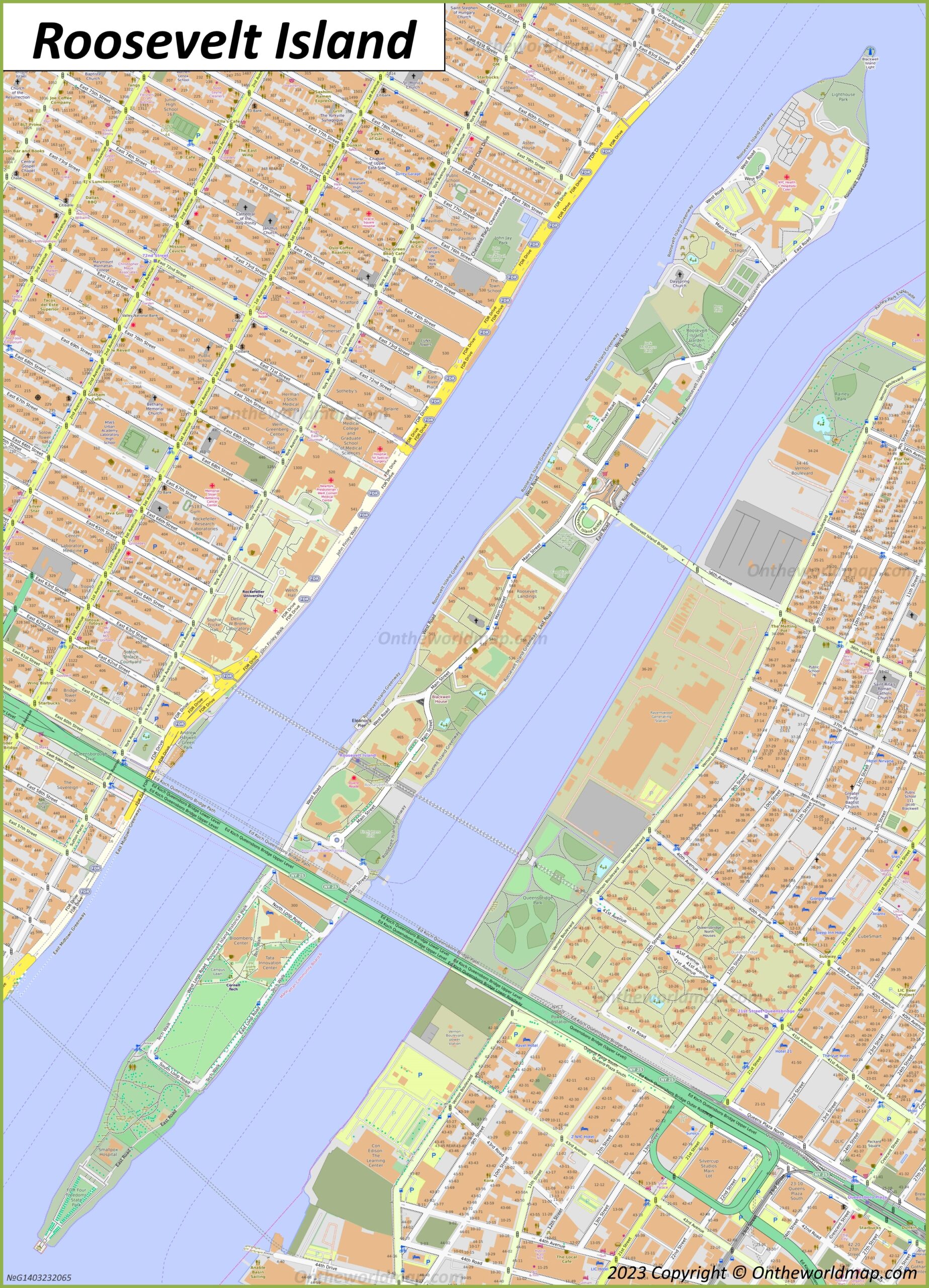
The Roosevelt Island map, updated in 2023, showcases the island’s 2-mile-long, 800-foot-wide expanse with remarkable detail. Positioned between the East River’s blue waters, the map features a grid of streets like Main Street and Roosevelt Island West Road, lined with residential buildings in orange. Green areas highlight parks such as Franklin D. Roosevelt Four Freedoms Park at the southern tip and Octagon Park to the north, offering lush escapes. The Queensboro Bridge and Roosevelt Island Bridge provide access, with landmarks like the Blackwell House and the ruins of the Smallpox Hospital adding historical depth. Yellow lines trace key routes, while icons mark amenities, painting a vivid picture of this urban oasis.
Purpose of the Map: Guiding Life and Exploration
This map serves as an indispensable tool for Roosevelt Island’s 12,000 residents and visitors, facilitating daily life and discovery. Locals use it to navigate to the Red Bus shuttle stops, access the F train station, or find community hubs like the Roosevelt Island Library. Tourists rely on it to explore historical sites, enjoy waterfront walks, or visit the Four Freedoms Park, designed by Louis Kahn. City planners and developers also utilize its layout to manage growth and preservation, ensuring the island balances its past with its present. Whether you’re commuting, sightseeing, or planning a move, this map makes it all effortless.
Daily Navigation for Residents and Visitors
For residents, the map simplifies trips to the tramway, grocery stores, or medical facilities at Coler Hospital. Visitors use it to locate the Smallpox Hospital ruins or plan a picnic at Lighthouse Park, with clear markers for parking and public transport. Its detailed street grid supports quick navigation, enhancing the island’s accessibility despite its isolation.
Historical and Urban Planning Insights
Beyond daily use, the map reflects Roosevelt Island’s rich history. Once called Blackwell’s Island, it housed prisons, hospitals, and a workhouse in the 19th century, with remnants like the Octagon Building still standing. The 2023 update highlights ongoing revitalization, showcasing how planners integrate green spaces and modern housing while honoring its past as a site of reform and resilience.
Interesting Facts: Diving into Roosevelt Island’s Legacy
- Island Evolution: Originally Minnehanonck to Native Americans, it became Blackwell’s Island in the 1600s, renamed Roosevelt Island in 1973 to honor Franklin D. Roosevelt.
- Historical Haunts: The Smallpox Hospital, abandoned since 1950, stands as a Gothic ruin, attracting photographers and historians.
- Green Escape: The Four Freedoms Park, opened in 2012, spans 4 acres and honors FDR’s vision, offering stunning East River views.
- Innovative Transit: The Roosevelt Island Tramway, launched in 1976, remains one of the few commuter cable cars in North America.
- Population Shift: From a population of 8,000 in the 1970s, it has grown to over 12,000, reflecting its transformation into a residential haven.
The Roosevelt Island map invites you to explore a slice of NYC where history and modernity coexist. Grab this guide, plan your visit, and stroll its peaceful paths or marvel at its architectural gems. Ready to escape the city’s chaos? Roosevelt Island beckons with open spaces and rich tales!
Uncover more USA travel treasures with our expert tips—your next island adventure awaits!