Google Maps™ driving directions home » Europe maps

Hungary

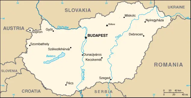
Driving Directions Hungary

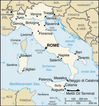
HUNGARY is a landlocked country sharing borders with Austria, Slovakia, Slovenia, Croatia, Serbia, Romania, and Ukraine. It is a region of plains ringed by the high mountain ranges of neighboring countries.

The main topographical feature is the Great Plain or Great Alföld, which is sit­uated east of the River Danube and extends southwards and eastwards across Hungary’s borders. North of the Great Plain, near the Hungarian border, there are several upland areas. A smaller Little Plain or Little Alföld occurs in the northwest and continues into southern Slovakia.

Read more

Google Maps™ driving directions home » Europe maps

Hungary Google Map

This image shows the draft map of Hungary, Europe. For more details of the map of Hungary, please see this page below. This image shows the location of Hungary, Europe. For more geographical details of Hungary, please see this page below. This image shows the flag of Hungary, Europe. For more details of the flag of Hungary, please see this page below.
Borderline map of Hungary Location map of Hungary Flag of Hungary

Hungary Google map

Google Maps and Detailed Facts of Hungary (HU). This page lets you explore Hungary and its border countries (Country Location: Central Europe, northwest of Romania) through detailed Satellite imagery – fast and easy as never before Google Maps.

Find comprehensive information about this country’s diversity below: Google maps, geography, economy, science, people, culture, environment, government, and history – All in One Wiki page.

There is also a Street View and free Driving Directions at your service. Your Google Satellite Map Sightseeing in Hungary, in Europe, starts here at Driving Directions and Maps.com.

Read more

Google Maps™ driving directions home » Europe maps

Iceland

Driving Directions Iceland

ICELAND is located in the North Atlantic Ocean about 298 kilometers or 186 miles east of Greenland and just south of the Arctic Circle. The island is roughly oval with the deeply indented coastline and numerous fjords and bays – a large, broad peninsula projects from the island’s northwestern corner.

Read more

Google Maps™ driving directions home » Europe maps

Ireland

Driving Directions Ireland

IRELAND is located on an island in the eastern part of the North Atlantic Ocean. Situated on the European continental shelf, it lies at the westernmost edge of Europe, to the west of Great Britain. The northeastern corner of the island is occupied by Northern Ireland, which belongs to Britain and is separated from the independent republic to its south by a winding border. Covering 70,280 square kilometers (27,135 square miles), Ireland is slightly larger than the state of West Virginia.

Read more

Google Maps™ driving directions home » Europe maps

Ireland Google Map

This image shows the draft map of Ireland, Europe. For more details of the map of Ireland, please see this page below. This image shows the location of Ireland, Europe. For more geographical details of Ireland, please see this page below. This image shows the flag of Ireland, Europe. For more details of the flag of Ireland, please see this page below.
Borderline map of Ireland Location map of Ireland Flag of Ireland

Ireland Google map

Google Maps and Detailed Facts of Ireland (IE). This page lets you explore Ireland and its border countries (Country Location: Western Europe, occupying five-sixths of the island of Ireland in the North Atlantic Ocean, west of Great Britain) through detailed Satellite imagery – fast and easy as never before Google Maps.

Find comprehensive information about this country’s diversity below: Google maps, geography, economy, science, people, culture, environment, government, and history – All in One Wiki page.

There is also a Street View and free Driving Directions at your service. Your Google Satellite Map Sightseeing in Ireland, in Europe, starts here at Driving Directions and Maps.com.

Read more

Google Maps™ driving directions home » Europe maps

Isle of Man Google Map

This image shows the draft map of Isle of Man, Europe. For more details of the map of Isle of Man, please see this page below. This image shows the location of Isle of Man, Europe. For more geographical details of Isle of Man, please see this page below. This image shows the flag of Isle of Man, Europe. For more details of the flag of Isle of Man, please see this page below.
Borderline map of Isle of Man Location map of Isle of Man Flag of Isle of Man

Isle of Man Google map

Google Maps and Detailed Facts of Isle of Man (IM). This page lets you explore Isle of Man and its border countries (Country Location: Western Europe, an island in the Irish Sea, between Great Britain and Ireland) through detailed Satellite imagery – fast and easy as never before Google Maps.

Find comprehensive information about this country’s diversity below: Google maps, geography, economy, science, people, culture, environment, government, and history – All in One Wiki page.

There is also a Street View and free Driving Directions at your service. Your Google Satellite Map Sightseeing in the Isle of Man, in Europe, starts here at Driving Directions and Maps.com.

Read more

Google Maps™ driving directions home » Europe maps

Italy

Driving Directions Italy

ITALY is a republic in southern Europe, which comprises a large penin­sula and the two main islands of Sicily (Sicilia) and Sardinia (Sardegna). The huge peaks of the Alps and the Dolomites form Italy’s northern bor­der with France, Switzerland, Austria, and Slovenia.

Towards the mountains’ foothills lie several large lakes, of which the most famous are Maggiore, Como, and Garda. The Adriatic Sea to the east separates Italy from the countries of former Yugoslavia. The fertile Plain of Lombardy lies to the south of the Alps. Numerous rivers rise in the north­ern mountains, and many become tributaries of the great River Po, which flows eastwards and drains the Lombardy Plain before emptying into the Adriatic Sea.

Read more

Google Maps™ driving directions home » Europe maps

Italy Google Map

This image shows the draft map of Italy, Europe. For more details of the map of Italy, please see this page below. This image shows the location of Italy, Europe. For more geographical details of Italy, please see this page below. This image shows the flag of Italy, Europe. For more details of the flag of Italy, please see this page below.
Borderline map of Italy Location map of Italy Flag of Italy

Italy Google map

Google Maps and Detailed Facts of Italy (IT). This page lets you explore Italy and its border countries (Country Location: Southern Europe, a peninsula extending into the central Mediterranean Sea, northeast of Tunisia) through detailed Satellite imagery – fast and easy as never before Google Maps.

Find comprehensive information about this country’s diversity below: Google maps, geography, economy, science, people, culture, environment, government, and history – All in One Wiki page.

There is also a Street View and free Driving Directions at your service. Your Google Satellite Map Sightseeing in Italy, in Europe, starts here at Driving Directions and Maps.com.

Read more

Google Maps™ driving directions home » Europe maps

Jersey Google Map

This image shows the draft map of Jersey, Europe. For more details of the map of Jersey, please see this page below. This image shows the location of Jersey, Europe. For more geographical details of Jersey, please see this page below. This image shows the flag of Jersey, Europe. For more details of the flag of Jersey, please see this page below.
Borderline map of Jersey Location map of Jersey Flag of Jersey

Jersey Google map

Google Maps and Detailed Facts of Jersey (JE). This page lets you explore Jersey and its border countries (Country Location: Western Europe, an island in the English Channel, northwest of France) through detailed Satellite imagery – fast and easy as never before Google Maps.

Find comprehensive information about this country’s diversity below: Google maps, geography, economy, science, people, culture, environment, government, and history – All in One Wiki page.

There is also a Street View and free Driving Directions at your service. Your Google Satellite Map Sightseeing in Jersey, in Europe, starts here at Driving Directions and Maps.com.

Read more

Google Maps™ driving directions home » Europe maps

Kiev Google maps

Kiev is one of the most populated cities in Ukraine, and at the same time, this city is the capital of this country. Located in Europe, you may find the city easily with the following GPS coordinates: 50.30N latitude / 30.28E longitude. For routing in Kiev, please check the free driving directions Kiev service below.

Read more