Explore the countries in Europe with all their Wiki, find information on weather, population, facts, history, landmarks of major cities data, and enjoy free Google maps Satellite imagery & Street views. Each Country Profile in Europe provides information on Geography data, area maps, Google maps, flag, history, area, population, the capital city, largest cities, economy, spoken languages, ethnicity/race, religion, literacy rate, government, and many more!
In this map category, you will find these European countries and their capital cities:
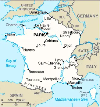
The lowest parts of the country are the great basins and low-lying plains of the north and southwest, which rise to meet the Massif Central, an extensive upland area, and the higher Alps’ mountains, Jura, and the Pyrenees. Mont Blanc on the France–Italy border is the highest point in the Alps at 4,807 meters or 15,770 feet.
Google Maps and Detailed Facts of France (FR). This page lets you explore France and its border countries through detailed Satellite imagery – fast and easy as never before Google Maps.
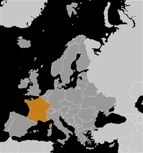
Location of metropolitan France: Western Europe, bordering the Bay of Biscay and the English Channel, between Belgium and Spain, southeast of the UK; bordering the Mediterranean Sea, Italy, and Spain.
Find comprehensive information about this country’s diversity below: Google maps, geography, economy, science, people, culture, environment, government, and history – All in One Wiki page.
There is also a Street View and free Driving Directions at your service. Your Google Satellite Map Sightseeing in France, in Europe, starts here at Driving Directions and Maps.com.
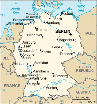
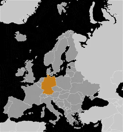
GERMANY is a large populous country in northern central Europe, which comprises the former East and West German Republics, reunified in 1990. In the north lies the North German Plain, which merges with the North Rhineland in the west. Further south, a plateau that stretches across the country from east to west is divided by the River Rhine. In the southwest, the Black Forest Mountains, or Schwarzwald, separate the Rhine Valley from Swabia’s fertile valleys and scarp lands. The Bavarian Forest is in the southeast, approaching the border with the Czech Republic. The Bohemian Uplands and Erz Mountains mark the border with the Czech Republic. The beautiful River Danube, the second-longest river in Europe, rises in the Bavarian Alps and crosses most southern Germany.
However, Germany’s most famous river is the mighty Rhine, which flows along the border with Switzerland and France before heading northwards towards the Netherlands and the North Sea.
The Rhine has several large and important tributaries, including the Neckar, Main, Lahn, Mosel, Ruhr, and Lippe, and is a major navigable waterway used to transport considerable amounts of freight. Because of heavy industrial development along much of the Rhine valley’s length, there are considerable problems with water pollution. Efforts continue to make, however, to address this situation and to improve water quality.
Google Maps and Detailed Facts of Germany (DE). This page lets you explore Germany and its border countries (Country Location: Central Europe, bordering the Baltic Sea and the North Sea, between the Netherlands and Poland, south of Denmark) through detailed Satellite imagery – fast and easy as never before Google Maps.
Find comprehensive information about this country’s diversity below: Google maps, geography, economy, science, people, culture, environment, government, and history – All in One Wiki page.
There is also a Street View and free Driving Directions at your service. Your Google Satellite Map Sightseeing in Germany, in Europe, starts here at Driving Directions and Maps.com.
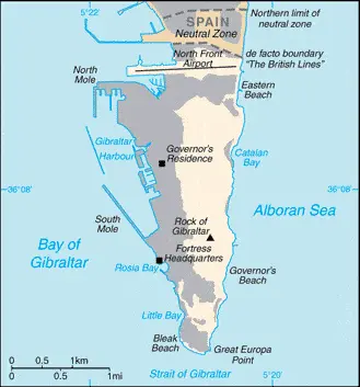
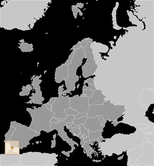
GIBRALTAR, or “The Rock”, is a limestone promontory situated at the end of a peninsula that forms the southernmost tip of Spain.
Its strategic importance, guarding as it makes the western approaches to the Mediterranean and separated from Morocco by the narrow Straits of Gibraltar, has meant that it has had a fascinating human history stretching back over thousands of years to Neolithic times.
Google Maps and Detailed Facts of Gibraltar (GI). This page lets you explore Gibraltar and its border countries (Country Location: Southwestern Europe, bordering the Strait of Gibraltar, which links the Mediterranean Sea and the North Atlantic Ocean, on the southern coast of Spain) through detailed Satellite imagery – fast and easy as never before Google Maps.
Find comprehensive information about this country’s diversity below: Google maps, geography, economy, science, people, culture, environment, government, and history – All in One Wiki page.
There is also a Street View and free Driving Directions at your service. Your Google Satellite Map Sightseeing in Gibraltar, in Europe, starts here at Driving Directions and Maps.com.
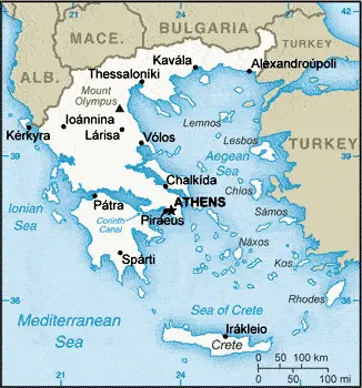
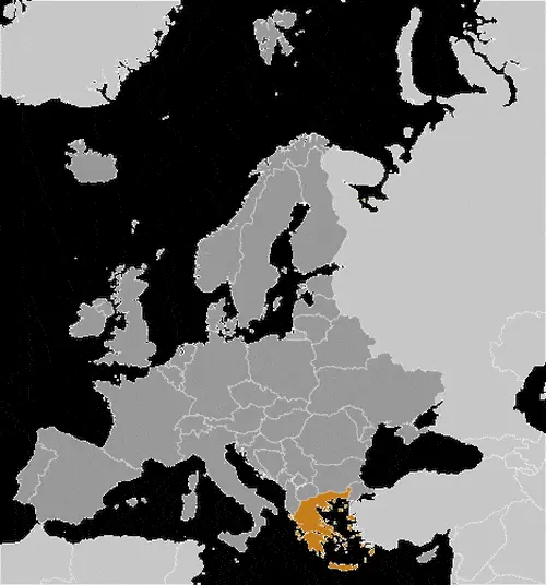
GREECE or the Hellenic Republic consists of a mainland portion and more than 1,400 islands. Mainland Greece occupies the southernmost portion of the Balkans Peninsula and shares borders with Albania in the northwest, with Macedonia (FYROM) and Bulgaria in the north, and Turkey in the northeast. The Aegean Sea lies to the east, the Mediterranean Sea to the south, and the Ionian Sea to the west.
The Ionian Islands (lonioi Nisoi), including Corfu (Kerkira), lie off the western mainland coast in the Ionian Sea. The remaining Greek islands scattered throughout the Aegean Sea. They include the Cyclades (Kikladhes) group in the southeast, Crete (Kriti) in the south, the Dodecanese group (Dhodhekanisos), including Rhodes (Rodhos), just west of mainland Turkey, the northern Aegean Islands, such a Thásos, Limnos, and Lésvós, and the Northern Sporades (Voriai Sporhadhes), situated off the eastern coast of Greece. In general, the islands are quite arid, hilly, and stony, with thin soils that are difficult to cultivate.
Google Maps and Detailed Facts of Greece (GR). This page lets you explore Greece and its border countries (Country Location: Southern Europe, bordering the Aegean Sea, Ionian Sea, and the Mediterranean Sea, between Albania and Turkey) through detailed Satellite imagery – fast and easy as never before Google Maps.
Find comprehensive information about this country’s diversity below: Google maps, geography, economy, science, people, culture, environment, government, and history – All in One Wiki page.
There is also a Street View and free Driving Directions at your service. Your Google Satellite Map Sightseeing in Greece, in Europe, starts here at Driving Directions and Maps.com.
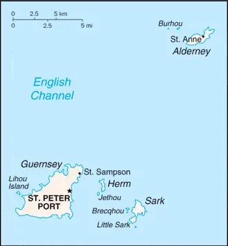
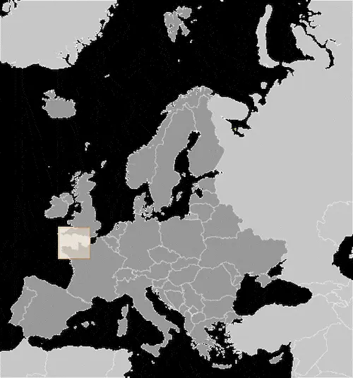
Google Maps and Detailed Facts of Guernsey (GG). This page lets you explore Guernsey and its border countries (Country Location: Western Europe, islands in the English Channel, northwest of France) through detailed Satellite imagery – fast and easy as never before Google Maps.
Find comprehensive information about this country’s diversity below: Google maps, geography, economy, science, people, culture, environment, government, and history – All in One Wiki page.
There is also a Street View and free Driving Directions at your service. Your Google Satellite Map Sightseeing in Guernsey, in Europe, starts here at Driving Directions and Maps.com.
Helsinki is one of the most populated cities in Finland, and at the same time, this city is the capital of this country. Located in Europe, you may find the city easily with the following GPS coordinates: 60.15N latitude / 25.03E longitude. For routing in Helsinki, please check the free driving directions Helsinki service below.
This website uses cookies to improve your experience. AcceptRead More
Privacy & Cookies Policy
Privacy Overview
This website uses cookies to improve your experience while you navigate through the website. Out of these, the cookies that are categorized as necessary are stored on your browser as they are essential for the working of basic functionalities of the website. We also use third-party cookies that help us analyze and understand how you use this website. These cookies will be stored in your browser only with your consent. You also have the option to opt-out of these cookies. But opting out of some of these cookies may affect your browsing experience.
Necessary cookies are absolutely essential for the website to function properly. This category only includes cookies that ensures basic functionalities and security features of the website. These cookies do not store any personal information.
Any cookies that may not be particularly necessary for the website to function and is used specifically to collect user personal data via analytics, ads, other embedded contents are termed as non-necessary cookies. It is mandatory to procure user consent prior to running these cookies on your website.