Google Maps™ driving directions home » Europe maps

Sweden

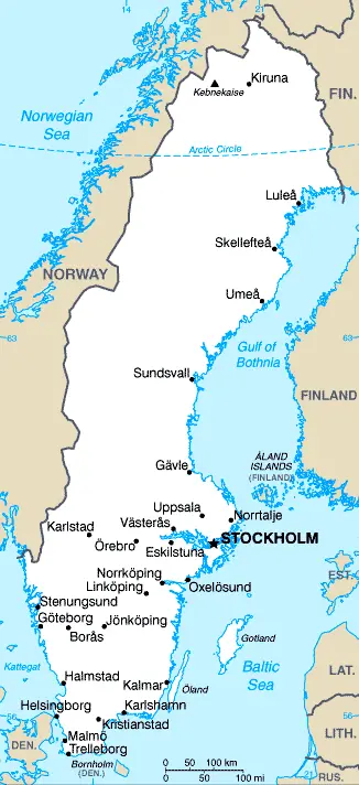
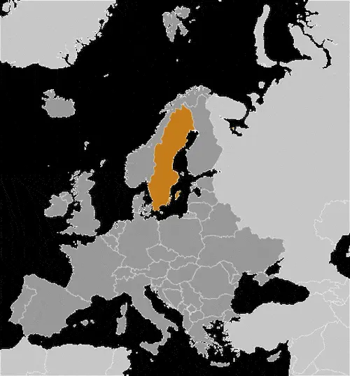
Driving Directions Sweden

Sweden is less mountainous than neighboring Norway, although the high mountain ranges that are such a dominant feature of the Scandinavian Peninsula extend across much of Sweden’s western boundary.

The highest mountains are north of the country, with Mount Kebhekaise (2,111 meters or 6,926 feet) reaching the most significant elevation. Glaciers occur at some of the higher levels.

Read more

Google Maps™ driving directions home » Europe maps

Sweden Google Map

Country map of Sweden This image shows the location of Sweden, Europe. For more geographical details of Sweden, please see this page below. This image shows the flag of Sweden, Europe. For more details of the flag of Sweden, please see this page below.
Borderline map of Sweden Location map of Sweden Flag of Sweden

Sweden Google map

Google Maps and Detailed Facts of Sweden (SE). This page lets you explore Sweden and its border countries (Country Location: Northern Europe, bordering the Baltic Sea, Gulf of Bothnia, Kattegat, and Skagerrak, between Finland and Norway) through detailed Satellite imagery – fast and easy as never before Google Maps.

Find comprehensive information about this country’s diversity below: Google maps, geography, economy, science, people, culture, environment, government, and history – All in One Wiki page.

There is also a Street View and free Driving Directions at your service. Your Google Satellite Map Sightseeing in Sweden, in Europe, starts here at Driving Directions and Maps.com.

Read more

Google Maps™ driving directions home » Europe maps

Switzerland

Driving Directions Switzerland

SWITZERLAND is a landlocked country in central Europe, sharing its borders with France, Italy, Austria, Liechtenstein, and Germany. It is dom­inated by the Alps, which occupy over 60 percent of the total land area.

A second lower mountain range, the Jura Mountains, occurs in the west of the country. These two leading east-west mountain chains are divided by the Rhine and Rhone rivers, and between them lies a plateau region at the height of about 396 meters or 1,300 feet above sea level.

Read more

Google Maps™ driving directions home » Europe maps

Switzerland Google Map

This image shows the draft map of Switzerland, Europe. For more details of the map of Switzerland, please see this page below. This image shows the location of Switzerland, Europe. For more geographical details of Switzerland, please see this page below. This image shows the flag of Switzerland, Europe. For more details of the flag of Switzerland, please see this page below.
Borderline map of Switzerland Location map of Switzerland Flag of Switzerland

Switzerland Google map

Google Maps and Detailed Facts of Switzerland (CH). This page lets you explore Switzerland and its border countries (Country Location: Central Europe, east of France, north of Italy) through detailed Satellite imagery – fast and easy as never before Google Maps.

Find comprehensive information about this country’s diversity below: Google maps, geography, economy, science, people, culture, environment, government, and history – All in One Wiki page.

There is also a Street View and free Driving Directions at your service. Your Google Satellite Map Sightseeing in Switzerland, in Europe, starts here at Driving Directions and Maps.com.

Read more

Google Maps™ driving directions home » Europe maps

Tallinn Google maps

Tallinn is one of the most populated cities in Estonia, and at the same time, this city is the capital of this country. Located in Europe, you may find the city easily with the following GPS coordinates: 59.22N latitude / 24.48E longitude. For routing in Tallinn, please check the free driving directions Tallinn service below.

Read more

Google Maps™ driving directions home » Europe maps

The United Kingdom

THE UNITED KINGDOM OF GREAT BRITAIN AND NORTHERN IRELAND (UK) is situated in northwest Europe and comprises England, Wales, Scotland, and the six counties of Northern Ireland. The latter is a historical and political entity rather than a geo­graphical one.

Also belonging to the United Kingdom are several hundred islands, many of them off the Scottish coast, and some are large and inhabited. In contrast, others are little more than rocky outcrops battered by stormy seas.

Read more

Google Maps™ driving directions home » Europe maps

The United Kingdom Google Map

The United Kingdom Google map

Google Maps and detailed facts about the United Kingdom (UK). This page lets you explore the United Kingdom and its border countries (Country Location: Western Europe, islands – including the northern one-sixth of the island of Ireland – between the North Atlantic Ocean and the North Sea; northwest of France) through detailed Satellite imagery – fast and easy as never before Google Maps.

Find comprehensive information about this country’s diversity below: Google maps, geography, economy, science, people, culture, environment, government, and history – All in One Wiki page.

There is also a Street View and free Driving Directions at your service. Your Google Satellite Map Sightseeing in the United Kingdom in Europe starts here at Driving Directions and Maps.com.

Read more

Google Maps™ driving directions home » Europe maps

The Vatican City

Driving Directions Vatican City

VATICAN CITY lies in the heart of Rome in Italy on a low hill on the west bank of the River Tiber; it is the world’s smallest independent state and headquarters of the Roman Catholic Church.

Read more

Google Maps™ driving directions home » Europe maps

Tirana Google maps

Tirana is one of the most populated cities in Albania, and at the same time, this city is the capital of this country. Located in Europe, you may find the city easily with the following GPS coordinates: 41.18N latitude / 19.49E longitude. For routing in Tirana, please check the free driving directions Tirana service below.

Read more

Google Maps™ driving directions home » Europe maps

Turkey

Driving Directions Turkey

TURKEY spans Europe and Asia’s continents and guards the sea passage between the Mediterranean Sea and the Black Sea. The mod­ern Republic of Turkey came into being in 1923 following the collapse of the Ottoman Empire and the Turkish War of Independence (1918-23).

Read more