Explore the countries in Asia with all their Wiki, find information on weather, population, facts, history, landmarks of major cities data, and enjoy free Google maps Satellite imagery & Street views. Each Country Profile in Asia provides information on Geography data, area maps, Google maps, flag, history, area, population, the capital city, largest cities, economy, spoken languages, ethnicity/race, religion, literacy rate, government, and many more!
In this map category, you will find these Asian countries and their capital cities:
MYANMAR (formerly Burma) is the second-largest country in Southeast Asia. The heartland of the country is the valley of the great Irrawaddy river system. The north and west of the country are mountainous, and the Shan Plateau runs along the border with Thailand in the east.
The climate is equatorial at the coast, changing to tropical monsoon over most of the interior.
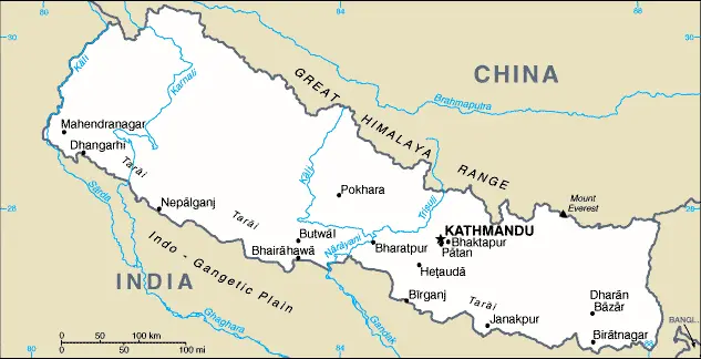
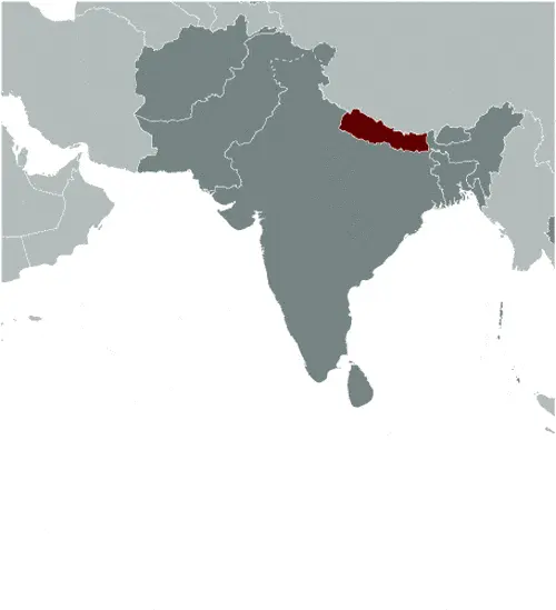
NEPAL is a constitutional monarchy with the Chinese autonomous region of Tibet lying on its northern, long side and surrounded by India on its other three sides to the west, south, and east.
The kingdom is divided into three topographical bands running northwesterly to the southeasterly direction: the high Himalayas, which extend along the northern border with Tibet, the more modest ranges of the Himalayas, and a narrow band of lower-lying land called the Tarai.
Google Maps and Detailed Facts of Nepal (NP). This page lets you explore Nepal and its border countries (Country Location: Southern Asia, between China and India) through detailed Satellite imagery – fast and easy as never before Google Maps.
Find comprehensive information about this country’s diversity below: Google maps, geography, economy, science, people, culture, environment, government, and history – All in One Wiki page.
There is also a Street View and free Driving Directions at your service. Your Google Satellite Map Sightseeing in Nepal, in Asia, starts here at Driving Directions and Maps.com.
New Delhi is one of the most populated cities in India, and at the same time, this city is the capital of this country. Located in Asia, you may easily find the city with the following GPS coordinates: 28.37N latitude / 77.13E longitude. For routing in New Delhi, please check the free driving directions New Delhi service below.
North Korea is located in eastern Asia and occupies the northern half of the Korean Peninsula. The Yalu and Tumen rivers form its northern border with China and Russia. The Korean Bay, an extension of the Yellow Sea, lies to the west, with the Sea of Japan to the east.
The Republic of Korea, formerly South Korea, occupies the southern part of the peninsula and is separated from the north by a buffer, demilitarised zone.
Mountains are the dominant topographical feature of North Korea, occupying the northern part of the country and extending southwards in broadband beside the coast of the Sea of Japan.
NORTHERN MARIANA ISLANDS are situated in the northwest Pacific Ocean. In 1986, the islanders voted for Commonwealth status in union with the USA, and they granted US citizenship.
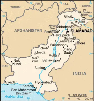
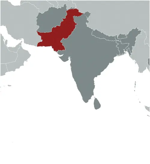
PAKISTAN lies just north of the Tropic of Cancer and has the Arabian Sea as its southern border. The far north of Pakistan covers Jammu and Kashmir’s disputed territory, which has been the cause of a severe conflict with India.
Google Maps and Detailed Facts of Pakistan (PK). This page lets you explore Pakistan and its border countries (Country Location: Southern Asia, bordering the Arabian Sea, India on the east and Iran and Afghanistan on the west, and China in the north) through detailed Satellite imagery – fast and easy as never before Google Maps.
Find comprehensive information about this country’s diversity below: Google maps, geography, economy, science, people, culture, environment, government, and history – All in One Wiki page.
There is also a Street View and free Driving Directions at your service. Your Google Satellite Map Sightseeing in Pakistan, in Asia, starts here at Driving Directions and Maps.com.
PALAU is a small republic in the Pacific Ocean, formerly called Belau or Belleau, which gained its independence from the United States trusteeship in 1994. It consists of a small number of volcanic islands and numerous coral atolls in the Caroline Group, about 900 kilometers or 625 miles equidistant from New Guinea to the south and the Philippines to the west.
Phnom Penh is one of the most populated cities in Cambodia, and at the same time, this city is the capital of this country. Located in Asia, you may find the city easily with the following GPS coordinates: 11.33N latitude / 104.55E longitude. For routing in Phnom Penh, please check the free driving directions Phnom Penh service below.
This website uses cookies to improve your experience. AcceptRead More
Privacy & Cookies Policy
Privacy Overview
This website uses cookies to improve your experience while you navigate through the website. Out of these, the cookies that are categorized as necessary are stored on your browser as they are essential for the working of basic functionalities of the website. We also use third-party cookies that help us analyze and understand how you use this website. These cookies will be stored in your browser only with your consent. You also have the option to opt-out of these cookies. But opting out of some of these cookies may affect your browsing experience.
Necessary cookies are absolutely essential for the website to function properly. This category only includes cookies that ensures basic functionalities and security features of the website. These cookies do not store any personal information.
Any cookies that may not be particularly necessary for the website to function and is used specifically to collect user personal data via analytics, ads, other embedded contents are termed as non-necessary cookies. It is mandatory to procure user consent prior to running these cookies on your website.