
 |
 |
 |
| Borderline map of Zambia | Location map of Zambia | Flag of Zambia |
Google Maps and Detailed Facts of Zambia (ZM). This page lets you explore Zambia and its border countries (Country Location: Southern Africa, east of Angola, south of the Democratic Republic of the Congo) through detailed Satellite imagery – fast and easy as never before Google Maps.
Find comprehensive information about this country’s diversity below: Google maps, geography, economy, science, people, culture, environment, government, and history – All in One Wiki page.
There is also a Street View and free Driving Directions at your service. Your Google Satellite Map Sightseeing in Zambia, in Africa, starts here at Driving Directions and Maps.com.
Zambia Google Maps & Satellite Maps
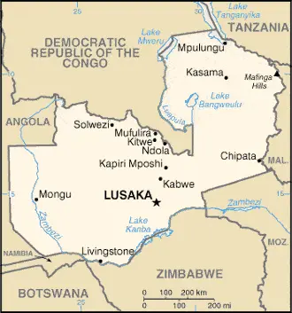
The map below shows Zambia with its cities, towns, highways, main roads, streets, and Street Views. To find a location, use the form below, type any city or place, view a simple map, and click the “show map” button.
The Google map above shows Zambia with its location: Africa (geographic coordinates: 15 00 S, 30 00 E) and the international borders of Zambia; total: 6,043.15 km. Border countries (total: 8): Angola 1,065 km, Botswana 0.15 km, the Democratic Republic of the Congo 2,332 km, Malawi 847 km, Mozambique 439 km, Namibia 244 km, Tanzania 353 km, Zimbabwe 763 km; furthermore, it’s inland counties boundaries.
Hint: Look at the Street view in Zambia or Africa. All you have to do is drag and pull the little yellow man (named: Pegman) on the Google map above the desired location. After that, whenever it is available (more than 50 countries globally), blue stripes will appear to show the photos and details from Google’s regularly updated data image base. In case if you have signed in to your Google account currently, you may have a look at the satellite map of this country/area as well.
The map of Zambia, Africa, is for informational use only. No representation is made or warrantied given any map or its content by Driving Directions and Maps site. The user assumes all risks of using this Zambia Google map and facts/wiki.
About Zambia in detail
Where is Zambia?
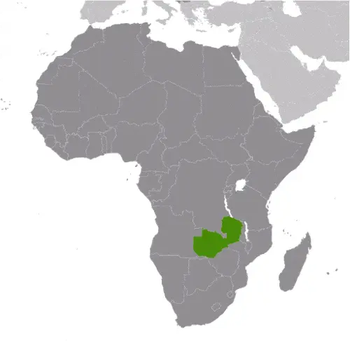
In case Zambia is looking on the map under the Coordinates 15 25 S 28 17 E otherwise in Africa, in Southern Africa, east of Angola, south of the Democratic Republic of the Congo.
What is the capital city of Zambia?
The capital city of Zambia is Lusaka.
What is the time in Lusaka?
It is 7 hours ahead of Washington, D.C. during Standard Time; Lusaka’s timezone is UTC+2.
What is the Internet code for Zambia?
The Top Level Domain (TLD) for Zambia is: .zm
What is the size of Zambia?
The territory of Zambia is total: 752,618 sq km; land: 743,398 sq km, water: 9,220 sq km.
If we want to describe the size of the territory of Zambia is slightly larger than Texas.
If we would like to walk around and discover Zambia, we can cover a total distance: 6,043.15 km.
What is the water coverage of Zambia?
We have already mentioned what percentage of Zambia is covered by water (see below), and this includes 0 km (landlocked country) coastline.
What is the climate like in Zambia?
The climate of Zambia is tropical: modified by altitude: rainy season (October to April).
Geographical data of Zambia
Zambia elevation; mean elevation: 1,138 m, elevation extremes; lowest point: Zambezi river 329 m, highest point: unnamed elevation in Mafinga Hills 2,301 m.
The specific geographical details of Zambia include mostly high plateau with some hills and mountains.
Suppose we would like to describe the countries location from a different perspective. In that case, it is safe to say, and easy to read from a map, Zambia is a landlocked country; the Zambezi forms a natural riverine boundary with Zimbabwe; Lake Kariba on the Zambia-Zimbabwe border forms the world’s largest reservoir by volume (180 cu km; 43 cu mi).
Resources and land use of Zambia
The country’s main mined products are copper, cobalt, zinc, lead, coal, emeralds, gold, silver, uranium, hydropower. The population partly uses the earlier highlighted land territory and partly left in its natural state: agricultural land: 31.7%; arable land 4.8%; permanent crops 0%; permanent pasture 26.9%; forest: 66.3%; other: 2% (2011 estimate).
Population data of Zambia
The number of inhabitants of Zambia is 15,510,711 (July 2016 estimate).
If we examine the proportion of the population distribution, it is safe to say that N/A.
If we look at the proportion of the urbanized and barely populated areas, these are the figures: urban population: 40.9% of the total population (2015).
Most of the population in Zambia is concentrated in LUSAKA (capital) 2.179 million (2015).
Ethnicity in Zambia
According to ethnicity details, the ethnic groups are Bemba 21%, Tonga 13.6%, Chewa 7.4%, Lozi 5.7%, Nsenga 5.3%, Tumbuka 4.4%, Ngoni 4%, Lala 3.1%, Kaonde 2.9%, Namwanga 2.8%, Lunda (north Western) 2.6%, Mambwe 2.5%, Luvale 2.2%, Lamba 2.1%, Ushi 1.9%, Lenje 1.6%, Bisa 1.6%, Mbunda 1.2%, other 13.8%, unspecified 0.4% (2010 estimate).
Spoken languages in Zambia
The spoken languages in Zambia are the following: Bembe 33.4%, Nyanja 14.7%, Tonga 11.4%, Lozi 5.5%, Chewa 4.5%, Nsenga 2.9%, Tumbuka 2.5%, Lunda (North Western) 1.9%, Kaonde 1.8%, Lala 1.8%, Lamba 1.8%, English (official language) 1.7%, Luvale 1.5%, Mambwe 1.3%, Namwanga 1.2%, Lenje 1.1%, Bisa 1%, other 9.7%, unspecified 0.2%. Note: Zambia is said to have over 70 languages, although many of these may be considered dialects; all of Zambia’s major languages are members of the Bantu family (2010 estimate).
What are the most important religions in Zambia?
According to this, during the general census, researchers examine the churches: Protestant 75.3%, Roman Catholic 20.2%, other 2.7% (includes Muslim Buddhist, Hindu, and Baha’i), none 1.8% (2010 estimate).
Further population data of Zambia
The proportion of gender and age tells a lot about the society as follows 0-14 years: 46.08% (male 3,590,466 / female 3,556,756) 15-24 years: 20% (male 1,550,183 / female 1,552,706) 25-54 years: 28.65% (male 2,239,661 / female 2,204,823) 55-64 years: 2.91% (male 211,039 / female 240,156) 65 years and over: 2.35% (male 158,827 / female 206,094) (2016 estimate). It also a significant factor in a society the population growth rate, which in the case of Zambia is 2.94% (2016 estimate).
The population growth rate is based on two elements, the birth, and the death rate. In Zambia the birth rate is 41.8 births / 1,000 population (2016 estimate), the death rate 12.4 deaths / 1,000 population (2016 estimate).
In this day and age in developed societies, the first child borns later compared to the previous centuries and decades, so childbearing is extended. In Zambia, the average age of mothers at the first childbirth is N/A.
Although the children’s birth is postponed in the best-case scenario, the parents can still see their kids grow as life expectancy also extended. In the case of Zambia, these figures are. With the introduction of modern medicine, vaccinations, and the proper hygienic conditions, the infant mortality rate is in a steep decline. The infant mortality statistics in Zambia are the following: N/A. Relevant data is the budget of healthcare, which is in this country’s case is 5% of GDP (2014).
Economic data of Zambia
Suppose we would like to describe a country, we also have to mention its economy; Zambia had one of the world’s fastest-growing economies for the ten years up to 2014, with real GDP growth averaging roughly 6.7% per annum, though growth slowed in 2015 and 2016 to just over 3%, due to falling copper prices, reduced power generation. Despite recent strong economic growth and its status as a lower-middle-income country, widespread and extreme rural poverty and high unemployment levels remain significant problems, made worse by a high birth rate, a relatively high HIV/AIDS burden. Poor management of water resources has also contributed to a power generation shortage, which has hampered industrial productivity and increased year-on-year inflation to more than 20% in 2016.
GDP is a prominent figure, as all the relevant calculations and statistics are based on it. GDP in Zambia is $20.57 billion (2015 estimate).
Another important indicator is the rate of GDP growth, which in Zambia is 3% (2016 estimate), 3% (2015 estimate) 5% (2014 estimate).
These statistics affect the world economy; remember, in 2015, the Chinese real GDP growth rate was worse than expected; The world markets fall, and the Chinese stock exchange was temporarily suspended.
A further major factor of a country’s economy, the GDP per capita. In Zambia this is $3,900 (2016 estimate) $3,900 (2015 estimate) $3,900 (2014 estimate).
In the economy, the Trinity is in common places, such as agriculture, industry, and services.
What are the agricultural products Zambia produces?
Zambia’s main agricultural products are corn, sorghum, rice, peanuts, sunflower seeds, vegetables, flowers, tobacco, cotton, sugarcane, cassava (manioc, tapioca), coffee; cattle, goats, pigs, poultry, milk, eggs, hides.
The essential segments are copper mining and processing, emerald mining, construction, foodstuffs, beverages, chemicals, textiles, fertilizer, and horticulture. The crucial and regularly mentioned GDP is based on copper mining and processing, emerald mining, construction, foodstuffs, beverages, chemicals, textiles, fertilizer, horticulture.
Drinking water source in Zambia
It is essential to mention that – thanks to the development of the infrastructure -, the rate of potable water improved: urban: 85.6% of the population, rural: 51.3% of the population, total: 65.4% of the population. Unimproved: urban: 14.4% of the population, rural: 48.7% of the people, total: 34.6% of the population (2015 estimate).
The average number of childbirth in Zambia
In Zambia, the average delivery number is 5.67 children born / woman (2016 estimate).
Population, median age, migration, and citizenship in Zambia
The population’s average age is 16.7 years; male: 16.6 years, female: 16.9 years (2016 estimate). The age of adulthood varies in every country of the world in Zambia; it is 18 years of age, universal.
When we are experiencing an unprecedented scale of migration and globalization, it is an important factor in the number of new immigrants. In Zambia is 0 migrant(s) / 1,000 population (2016 estimate). It is important to know how to apply for citizenship: citizenship by birth: yes. Citizenship by descent: yes. Dual citizenship recognized: no. The residency requirement for naturalization: not specified.
Is Zambia a safe destination? Healthcare services and infectious diseases in Zambia
Many of the travelers are looking into the healthcare services and infectious diseases of their destinations. In Zambia, the hospital beds’ density is two beds / 1,000 population (2010).
According to the WHO rating regarding contagious diseases in Zambia, the degree of risk: very high food or waterborne diseases: bacterial and protozoal diarrhea, hepatitis A, and typhoid fever vectorborne diseases: malaria and dengue fever water contact disease: schistosomiasis. Animal contact disease: rabies, (2016).
However, HIV is not curable but maintainable. Let’s do not forget when the disease surfaced; it was a world threatening condition. Unfortunately, in some countries, it is still very high the number of infected patients and fatalities due to the disease.
In Zambia, the number of HIV/AIDS deaths: N/A.
Regarding tourism obesity, not an important issue, but we have to mention health statistics, as it is the plague of the 20th and the 21st century. The rate of obese adults in Zambia is 7.2% (2014).
What are the natural hazards in Zambia? Is there any?
The most known natural risk in Zambia is periodic drought; tropical storms (November to April).
More interesting facts about Zambia
A few words about the past, as every country and society, is connected to its history; the former British South Africa Company administered the territory of Northern Rhodesia from 1891 until it the UK took it over in 1923. During the 1920s and 1930s, advances in mining spurred development and immigration. The name was changed to Zambia upon independence in 1964. In the 1980s and 1990s, declining copper prices, economic mismanagement, and a prolonged drought hurt the economy. Elections in 1991 brought an end to one-party rule and propelled the Movement for Multiparty Democracy (MMD) to government. However, the subsequent vote in 1996 saw increasing harassment of opposition parties and abuse of state media and other resources. The election in 2001 was marked by administrative problems, with three parties filing a legal petition challenging the election of ruling party candidate Levy MWANAWASA.
MWANAWASA was re-elected in 2006 in an election that was deemed free and fair. Upon his death in August 2008, he was succeeded by his vice president, Rupiah BANDA, who won a special presidential byelection later that year. The MMD and BANDA lost to the Patriotic Front (PF) and Michael SATA in the 2011 general elections. However, SATA presided over a period of haphazard economic management and attempted to silence opposition to PF policies. SATA died in October 2014 and was succeeded by his vice president, Guy SCOTT, who served as interim president until special elections were held in January 2015. Edgar LUNGU won the presidential by-election and will complete SATA’s term, which expires in August 2016 when new presidential and parliamentary, and local elections will be held.
In every nation’s memory, some cornerstones placed the country on the timeline of history. The date of declaration of independence of Zambia: 24 October 1964 (from the UK).
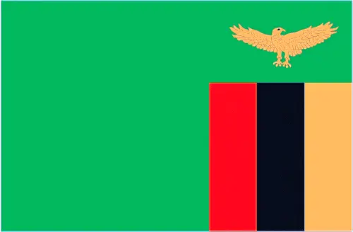
The flag and other symbols of Zambia
The colors, symbols, and animals on the flag usually have a historical background or an important milestone or memory of the nation.
This case is not an exception either; green field with a panel of three vertical bands of red (hoist side), black, and orange below a soaring orange eagle, on the outer edge of the flag; green stands for the country’s natural resources and vegetation, red symbolizes the struggle for freedom, black the people of Zambia, and orange the country’s mineral wealth; the eagle represents the people’s ability to rise above the nation’s problems.
Apart from the flag, the symbol of national unity is the national anthem. The anthem’s primary purpose is to share the nation’s core values, endeavors, and patriotic feelings.
Zambia’s national symbols: African fish eagle; national colors: green, red, black, orange.
Constitution of Zambia
The existence of the nation is based on the constitution. Some constitutions knew worldwide, like the U.S. Constitution that was accepted on the 17th of September 1787, in Philadelphia, the United States of America’s Constitution.
It is not related to the declaration of independence that was stolen by Nicolas Cage in the movie National Treasure 🙂
What is the legal system of Zambia?
Most of the time, the legal system of a country is the focus of lawyers. It is a common fact that there are two main approaches in the world, “the law in books” and “the law in action.”
In the Anglo-Saxon world, the practice is the “law in action,” while in the rest of the world, the law is based on Roman law, the “law in books.”
The legal system of Zambia is a mixed legal system of English common law and customary law.
It was Aristotle who founded the Theory of 3 separations of powers. In his view, these are the council of public affairs, the magistrates, and the justice system. The age of enlightenment was the time when terminologies have defined the way we still use them. In most democratic countries, the three authorities separated from each other. In dictatorships, the rules usually interweaved in one hand.
About the legislative branch of Zambia, we can highlight the following structures unicameral National Assembly (164 seats; 156 members directly elected in single-seat constituencies by simple majority vote, and eight appointed by the president; members serve 5-year terms); note – 6 additional electoral seats were added for the 11 August 2016 election, up from 150 electoral seats in the 2011 election.
About the unemployment rate, labor force, and poverty line in Zambia
One of the major problems of the 21st-century economy is unemployment. Governments are struggling to maintain a low level of the unemployment rate. Still, as a result of automation, the cheap 3rd world labor, and the outsourcing of workflow, these attempts fail. In Zambia, the labor force is 7.116 million (2016 estimate). Please bear in mind that the population in Zambia is total: 62.9 deaths / 1,000 live births; male: 68.3 deaths / 1,000 live births, female: 57.3 deaths / 1,000 live births (2016 estimate) – as we already mentioned above.
The rate of unemployment in Zambia is 15% (2008 estimate).
Widely known that the gap between the rich and poor is widening on an enormous scale.
According to the 2017 shocking Oxfam report, the most affluent eight people’s fortune is equal to the wealth of the poorest half of the world’s population.
In Zambia, the households’ income and consumption compared to the entire population: lowest 10%: 1.5% highest 10%: 47.4% (2010).
Another widely used indicator is the so-called GINI index, which measures the inequalities of statistical dispersion, but is mainly used for measuring the sharing of income and fortune.
The GINI index was named after its founder Corrado Gini, an Italian economist. Gini index has grades between 0-1, but often it is used on a percentage basis. It is 0 if the examined criteria territorial distribution is equal. It is one of the criteria concentrated on the territory. In Zambia, the GINI index is .57,5 (2013).
The states usually set up a poverty line, which is more or less, is a subjective measure. It varies by country; its base is often the minimum pension, the incomes of the most deficient 20 percent, the X percent of income per capita Etc.
In Zambia, the poverty line people are the lowest 10%: 1.5% highest 10%: 47.4% (2010).
About the budget and central governments debt of Zambia
The available budget mainly defines the state’s economy. Zambia’s budget is; revenues: $3.418 billion, expenditures: $5.079 billion (2016 estimate). Taxes and other revenues are 16.6% of GDP (2016 estimate).
The budget deficit (Budget surplus (+) or deficit (-)) is N/A.
The fiscal year in Zambia is the calendar year.
In the country’s economy, we have to consider the public debt. Public debt is the consolidated sum of the state’s local, federal, and central government debt.
Inflation rate and prime lending rate in Zambia
A few further interesting and relevant economic data are the following; Inflation rate: 20.7% (2016 estimate), 10.1% (2015 estimate), and the rate of the Commercial bank prime lending rate: 15.7% (31 December 2016 estimate).
Export/import partners and data of Zambia
Zambia, with the export of products, industrial tools, and other services, generates revenue. Zambia’s export value is $6.609 billion (2016 estimate), $6.998 billion (2015 estimate). The total revenue of these activities: copper/cobalt, cobalt, electricity; tobacco, flowers, cotton.
The most important export partners of Zambia are China 25.5%, the Democratic Republic of the Congo 13%, South Africa 6.4%, South Korea 4.9%, India 4.3% (2015).
The most important imported products are machinery, transportation equipment, petroleum products, electricity, fertilizer, foodstuffs, clothing, and the countries from where the import is coming: South Africa 34.5%, the Democratic Republic of the Congo 18.2%, Kenya 9.7%, China 7.3%, India 4.4% (2015).
Renewable energies used in Zambia
To suppress the pollution of the environment, renewable energies have to replace the fossil energy. The more the proportion of renewable energies in a country means more effort against pollution. Zambia, the indicator of how much of the country’s produced energy is coming from the hydroelectric source, is 99.6% of total installed capacity (2012 estimate).
To indicate how much another renewable energy produced is 0% of total installed capacity (2012 estimate).
Telecommunication data of Zambia, calling code
To maintain the economy, the development of a reliable and modern telecommunications infrastructure is crucial. We can say the following about Zambia; among the best in sub-Saharan Africa. Domestic: high-capacity microwave radio relay connects most larger towns and cities; several cellular telephone services in operation and network coverage is improving; domestic satellite system being installed to improve telephone service in rural areas; Internetinternational: country code – 260; satellite earth stations – 2 Intelsat (1 Indian Ocean and one the Atlantic Ocean), three owned by Zamtel (2010).
Transport infrastructure in Zambia
In the 21st century, we often say that the world has become small and there are no distances anymore. With widespread air travel when (sometimes) there are no visa restrictions, it is easy to reach other countries, but if the distance is not too long, we can also use railway or water transportation.
The number of airports in Zambia: 88 (2013), and the number of heliports: N/A.
The total length of the roadways in Zambia: total: 40,454 km, paved: 9,403 km, unpaved: 31,051 km (2005).
The total length of the waterways in Zambia: 2,250 km (includes Lake Tanganyika and the Zambezi and Luapula rivers) (2010).
Are you traveling to Zambia?
If you plan to travel by plane to Zambia, try our air ticket comparison site, where you can choose from hundreds of carriers and offers. Our application is scanning the market and shows you the best and the cheapest deals without any extra charge or commission.
Are you looking for a hotel, apartment another kind of accommodation in Zambia, Africa? We are here to help you to find your accommodation from budget to luxury. Our search engine is scanning, regularly updating data from hundreds of accommodation websites and more than a million offers. You can quickly and easily find your hotel stay anywhere in the world, without any extra charge or commission.
Facts & data about Zambia
Name of the country: conventional long way: the Republic of Zambia, traditional short form: Zambia, former: Northern Rhodesia, etymology: name derived from the Zambezi River through the western part of the country and formed its southern border with neighboring Zimbabwe.
| Abbreviation: Zambia | Geographic coordinates: 15 00 S, 30 00 E |
Country Location: Africa |
| Capital of Zambia: Lusaka | GPS of the Capital: 15 25 S 28 17 E |
Position: Southern Africa, east of Angola, south of the Democratic Republic of the Congo |
| Land area: total: 752,618 sq km; land: 743,398 sq km, water: 9,220 sq km | Terrain: mostly high plateau with some hills and mountains |
Area comparative: slightly larger than Texas |
| Population: 15,510,711 (July 2016 estimate) | Population grow rate: 2.94% (2016 estimate) | Sex ratio: at birth: 1.03 male(s) / female, 0-14 years: 1.01 male(s) / female, 15-24 years: 1 male(s) / female, 25-54 years: 1.02 male(s) / female, 55-64 years: 0.88 male(s) / female, 65 years and over: 0.76 male(s) / female, total population: 1 male(s) / female (2016 estimate) |
| Exports: $6.609 billion (2016 estimate), $6.998 billion (2015 estimate) | Imports: $6.752 billion (2016 estimate), $7.711 billion (2015 estimate) | Import partners: South Africa 34.5%, Democratic Republic of the Congo 18.2%, Kenya 9.7%, China 7.3%, India 4.4% (2015) |
| Urbanization: urban population: 40.9% of the total population (2015) | Major urban area(s): LUSAKA (capital) 2.179 million (2015) | Median age: total: 16.7 years; male: 16.6 years, female: 16.9 years (2016 estimate) |
| Internet users: total: 3.164 million. Percent of the population: 21% (July 2015 estimate) | Telephones (fixed-lines): total subscriptions: 116,165. Subscriptions per 100 inhabitants: 1 (July 2015 estimate) | Telephones (mobile, cellular): total: 11.558 million. Subscriptions per 100 inhabitants: 77 (July 2015 estimate) |
| Unemployment rate: 15% (2008 estimate) | Nationality: Zambian(s) adjective: Zambian | National holidays: Independence Day, 24 October (1964) |
| Life expectancy at birth: total population: 52.5 years. Male: 50.8 years, female: 54.1 years (2016 estimate) | Total fertility rate: 5.67 children born / woman (2016 estimate) | Birthrate: 41.8 births / 1,000 population (2016 estimate) |
| Literacy: age 15 and over can read and write Englis. Total population: 63.4%; male: 70.9%, female: 56% (2015 estimate) | Legal system: mixed legal system of English common law and customary law | Suffrage: 18 years of age, universal |
| Industries: copper mining and processing, emerald mining, construction, foodstuffs, beverages, chemicals, textiles, fertilizer, horticulture | Industrial production growth rate: 0.2% (2016 estimate) | GDP real growth rate: 3% (2016 estimate) 3% (2015 estimate) 5% (2014 estimate) |
Do you like this Zambia Google maps™ & country information page?
Please do us a favor: Share or like this page using the icons at the top of the page. We also do encourage you to visit our Facebook page for more travel and country related information.
Many thanks for visiting and sharing this map & country information site!