
 |
 |
 |
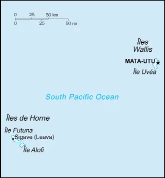
| Borderline map of Wallis and Futuna | Location map of Wallis and Futuna | Flag of Wallis and Futuna |
Google Maps and Detailed Facts of Wallis and Futuna (WF). This page lets you explore Wallis and Futuna and its border countries (Country Location: Oceania, islands in the South Pacific Ocean, about two-thirds of the way from Hawaii to New Zealand) through detailed Satellite imagery – fast and easy as never before Google Maps.
Find comprehensive information about this country’s diversity below: Google maps, geography, economy, science, people, culture, environment, government, and history – All in One Wiki page.
There is also a Street View and free Driving Directions at your service. Your Google Satellite Map Sightseeing in Wallis and Futuna, in Oceania, starts here at Driving Directions and Maps.com.
Wallis and Futuna Google Maps & Satellite Maps
The map below shows Wallis and Futuna with its cities, towns, highways, main roads, streets, and Street Views. To find a location, use the form below, type any city or place, view a simple map, and click the “show map” button.
The Google map above shows Wallis and Futuna with its location: Oceania (geographic coordinates: 13 18 S, 176 12 W) and Wallis and Futuna; 0 km; furthermore, it’s inland counties boundaries.
Hint: Look at the Street view in Wallis and Futuna, or Oceania. All you have to do is drag and pull the little yellow man (named: Pegman) on the Google map above the desired location. After that, whenever it is available (more than 50 countries globally), blue stripes will appear to show the photos and details from Google’s regularly updated data image base. In case if you have signed in to your Google account currently, you may have a look at the satellite map of this country/area as well.
The map of Wallis and Futuna, Oceania, is for informational use only. No representation is made or warrantied given any map or its content by Driving Directions and Maps site. The user assumes all risks of using this Wallis and Futuna Google map and facts/wiki.
About Wallis and Futuna in detail
Where are Wallis and Futuna?
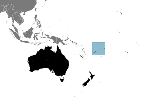
Wallis and Futuna, in case, if you are looking on the map under the Coordinates 13 57 S 171 56 W otherwise in Oceania, in Oceania, islands in the South Pacific Ocean, about two-thirds of the way from Hawaii to New Zealand.
What is the capital city of Wallis and Futuna?
The capital city of Wallis and Futuna is Mata-Utu.
What is the time in Mata-Utu?
It is 17 hours ahead of Washington, D.C. during Standard Time; Mata-Utu’s timezone is UTC+12.
What is the Internet code for Wallis and Futuna?
The Top Level Domain (TLD) for Wallis and Futuna is: .wf
What is the size of Wallis and Futuna?
Wallis and Futuna’s territory is total: 142 sq km; land: 142 sq km, water: 0 sq km.
If we want to describe the size of Wallis and Futuna’s territory is 1.5 times the size of Washington, DC.
If we would like to walk around and discover Wallis and Futuna, we can cover a distance of 0 km.
What is the water coverage of Wallis and Futuna?
We have already mentioned what percentage of Wallis and Futuna is covered by water (see below), and this includes 129 km coastline.
What is the climate like in Wallis and Futuna?
The climate of Wallis and Futuna is tropical: hot, rainy season (November to April): cool, dry season (May to October): rains 250-300 cm per year (80% humidity): average temperature 26.6 degrees Celsius.
Geographical data of Wallis and Futuna
Wallis and Futuna; mean elevation: N/A, elevation extremes; lowest point: Pacific Ocean 0 m, highest point: Mont Singavi 765 m.
The specific geographical details of Wallis and Futuna include volcanic origin; low hills.
Suppose we would like to describe the countries location from a different perspective. In that case, it is safe to say, and easy to read from a map, Wallis and Futuna are both island groups that have fringing reefs.
Resources and land use of Wallis and Futuna
The country’s main mined products are NEGL. The population partly uses the earlier highlighted land territory and partly left in its natural state: agricultural land: 42.8%; arable land 7.1%; permanent crops 35.7%; permanent pasture 0%; forest: 41.9%; other: 15.3% (2011 estimate).
Population data of Wallis and Futuna
The number of inhabitants of Wallis and Futuna is 15,664 (July 2016 estimate).
If we examine the proportion of the population distribution, it is safe to say that N/A.
If we look at the proportion of the urbanized and barely populated areas, these are the figures: urban population: 0% of the total population (2015).
Most of Wallis and Futuna’s population is concentrated in MATA-UTU (capital) 1,000 (2014).
Ethnicity in Wallis and Futuna
According to ethnicity details, the ethnic groups are Polynesian.
Spoken languages in Wallis and Futuna
The spoken languages in Wallis and Futuna are the following: Wallisian (an indigenous Polynesian language) 58.9%, Futunian 30.1%, French (official language) 10.8%, other 0.2% (2003 census).
What are the most important religions in Wallis and Futuna?
According to this, during the general census, researchers examine the churches: Roman Catholic 99%, other 1%.
Further population data of Wallis and Futuna
The proportion of gender and age tells a lot about the society as follows 0-14 years: 22.25% (male 1,819 / female 1,667) 15-24 years: 16.9% (male 1,395 / female 1,252) 25-54 years: 41.52% (male 3,266 / female 3,237) 55-64 years: 9.7% (male 746 / female 773) 65 years and over: 9.63% (male 721 / female 788) (2016 estimate). It also a significant factor in a society the population growth rate, which in the case of Wallis and Futuna is 0.33% (2016 estimate).
The population growth rate is based on two elements, the birth, and the death rate. In Wallis and Futuna the birth rate is 13.3 births / 1,000 population (2016 estimate), the death rate 5.2 deaths / 1,000 population (2016 estimate).
In this day and age in developed societies, the first child borns later compared to the previous centuries and decades, so childbearing is extended. In Wallis and Futuna, the average age of mothers at the first childbirth is N/A.
Although the children’s birth is postponed in the best-case scenario, the parents can still see their kids grow as life expectancy also extended. In the case of Wallis and Futuna, these figures are. With the introduction of modern medicine, vaccinations, and the proper hygienic conditions, the infant mortality rate is in a steep decline. The infant mortality statistics in Wallis and Futuna are the following: N/A. Relevant data is the budget of healthcare, which is in the case of this country is N/A.
Economic data of Wallis and Futuna
Suppose we would like to describe a country, we also have to mention its economy; The economy is limited to traditional subsistence agriculture, with 80% of labor force earnings coming from agriculture (coconuts and vegetables), livestock (mostly pigs), and fishing. However, roughly 70% of the labor force is employed in the public sector. Revenues come from French Government subsidies, licensing of fishing rights to Japan and South Korea, import taxes, and remittances from expatriate workers in New Caledonia. France directly finances the public sector and healthcare and education services. A key concern for Wallis and Futuna is an aging population with consequent economic development issues. Very few people aged 18-30 live on the islands due to the limited formal employment opportunities. Improving job creation is a current priority for the.
GDP is a prominent figure, as all the relevant calculations and statistics are based on it. GDP in Wallis and Futuna is $NA.
Another important indicator is the rate of GDP growth, which in Wallis and Futuna is N/A%.
These statistics affect the world economy; remember, in 2015, the Chinese real GDP growth rate was worse than expected; The world markets fall, and the Chinese stock exchange was temporarily suspended.
A further major factor of a country’s economy, the GDP per capita. In Wallis and Futuna, this is $3,800 (2004 estimate).
In the economy, the Trinity is in common places, such as agriculture, industry, and services.
What are the agricultural products Wallis and Futuna produce?
The main agricultural products of Wallis and Futuna are coconuts, breadfruit, yams, taro, bananas, pigs, goats, fish.
Regarding the economy, the essential segments are copra, handicrafts, fishing, lumber. The crucial and regularly mentioned GDP is based on copra, handicrafts, fishing, lumber.
Drinking water source in Wallis and Futuna
It is essential to mention that – thanks to the infrastructure development– the rate of potable water N/A.
The average number of childbirth in Wallis and Futuna
In Wallis and Futuna, the average delivery number is 1.74 children born / woman (2016 estimate).
Population, median age, migration, and citizenship in Wallis and Futuna
The population’s average age is 31.6 years; male: 30.6 years, female: 32.8 years (2016 estimate). The age of adulthood varies in every country of the world in Wallis and Futuna; it is 18 years of age, universal.
When we are experiencing an unprecedented scale of migration and globalization, it is an important factor in the number of new immigrants. In Wallis and Futuna is -4.9 migrant(s) / 1,000 population. Note: there has been steady emigration from Wallis and Futuna to New Caledonia (2016 estimate). It is important to know how to apply for citizenship: see France.
Are Wallis and Futuna a safe destination? Healthcare services and infectious diseases in Wallis and Futuna
Many of the travelers are looking into the healthcare services and infectious diseases of their destinations. In Wallis and Futuna, the hospital beds’ density is N/A.
According to the WHO rating regarding contagious diseases in Wallis and Futuna: N/A.
However, HIV is not curable but maintainable. Let’s do not forget when the disease surfaced; it was a world threatening condition. Unfortunately, in some countries, it is still very high the number of infected patients and fatalities due to the disease.
In Wallis and Futuna, the number of HIV/AIDS deaths: N/A.
Regarding tourism obesity, not an important issue, but we have to mention health statistics, as it is the plague of the 20th and the 21st century. The rate of obese adults in Wallis and Futuna is N/A.
What are the natural hazards in Wallis and Futuna? Is there any?
The most known natural risk in Wallis and Futuna is N/A.
More interesting facts about Wallis and Futuna
A few words about the past, as every country and society, is connected to its history; The Futuna island group was discovered by the Dutch in 1616 and Wallis by the British in 1767, but it was the French who declared a protectorate over the islands in 1842 and took official control of them between 1886 and 1888. Notably, Wallis and Futuna was the only French colony to side with the Vichy regime during World War II, a phase that ended in May of 1942 with 2,000 American troops’ arrival. In 1959, the islands’ inhabitants voted to become a French overseas territory and officially assumed this status in July 1961.
In every nation’s memory, some cornerstones placed the country on the timeline of history. The date of declaration of independence of Wallis and Futuna: none (overseas territory of France).
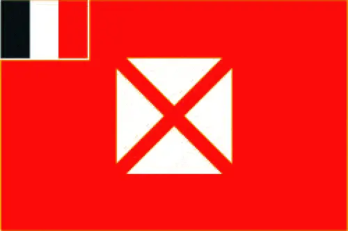
The flag and other symbols of Wallis and Futuna
The colors, symbols, and animals on the flag usually have a historical background or an important milestone or memory of the nation.
This case is not an exception either; the unofficial, local flag has a red field with four white isosceles triangles in the middle, representing the three native kings of the islands and the French administrator; the apexes of the triangles are oriented inward and at right angles to each other; the flag of France, outlined in white on two sides, is in the upper hoist quadrant. Note: the design is derived from an original red banner with a white cross pattee introduced in the 19th century by French missionaries; the flag of France is used for official occasions.
Apart from the flag, the symbol of national unity is the national anthem. The anthem’s primary purpose is to share the nation’s core values, endeavors, and patriotic feelings.
National symbols of Wallis and Futuna: red saltire (Saint Andrew’s Cross) on a white square on a red field; national colors: red, white.
Constitution of Wallis and Futuna
The existence of the nation is based on the constitution. Some constitutions knew worldwide, like the U.S. Constitution that was accepted on the 17th of September 1787, in Philadelphia, the United States of America’s Constitution.
It is not related to the declaration of independence that was stolen by Nicolas Cage in the movie National Treasure 🙂
What is the legal system of Wallis and Futuna?
Most of the time, the legal system of a country is the focus of lawyers. It is a common fact that there are two main approaches in the world, “the law in books” and “the law in action.”
In the Anglo-Saxon world, the practice is the “law in action,” while in the rest of the world, the law is based on Roman law, the “law in books.”
The legal system of Wallis and Futuna is French civil law.
It was Aristotle who founded the Theory of 3 separations of powers. In his view, these are the council of public affairs, the magistrates, and the justice system. The age of enlightenment was the time when terminologies have defined the way we still use them. In most democratic countries, the three authorities separated from each other. In dictatorships, the rules usually interweaved in one hand.
About the legislative branch of Wallis and Futuna, we can highlight the following structures unicameral Territorial Assembly or Assemblee Territoriale (20 seats; members directly elected in multi-seat constituencies by proportional representation to serve 5-year terms). Note: Wallis and Futuna elect one senator to the French Senate and one deputy to the French National Assembly.
About the unemployment rate, labor force, and poverty line in Wallis and Futuna
One of the major problems of the 21st-century economy is unemployment. Governments are struggling to maintain a low level of the unemployment rate. Still, as a result of automation, the cheap 3rd world labor, and the outsourcing of workflow, these attempts fail. In Wallis and Futuna, the labor force is 3,104 (2003). Please bear in mind that the population in Wallis and Futuna is total: 4.4 deaths / 1,000 live births; male: 4.6 deaths / 1,000 live births, female: 4.1 deaths / 1,000 live births (2016 estimate) – as we already mentioned above.
The rate of unemployment in Wallis and Futuna is 12.2% (2008 estimate).
Widely known that the gap between the rich and poor is widening on an enormous scale.
According to the 2017 shocking Oxfam report, the most affluent eight people’s fortune is equal to the wealth of the poorest half of the world’s population.
In Wallis and Futuna, the households’ income and consumption compared to the entire population: lowest 10%: N/A% highest 10%: N/A%.
Another widely used indicator is the so-called GINI index, which measures the inequalities of statistical dispersion, but is mainly used for measuring the sharing of income and fortune.
The GINI index was named after its founder Corrado Gini, an Italian economist. Gini index has grades between 0-1, but often it is used on a percentage basis. It is 0 if the examined criteria territorial distribution is equal. It is one of the criteria concentrated on the territory. In Wallis and Futuna, the GINI index is N/A.
The states usually set up a poverty line, which is more or less, is a subjective measure. It varies by country; its base is often the minimum pension, the incomes of the most deficient 20 percent, the X percent of income per capita Etc.
In Wallis and Futuna, the poverty line people are the lowest 10%: N/A% highest 10%: N/A%.
About the budget and central governments debt of Wallis and Futuna
The available budget mainly defines the state’s economy. The budget of Wallis and Futuna is; revenues: $29,730expenditures: $31,330 (2004). Taxes and other revenues are N/A%.
The budget deficit (Budget surplus (+) or deficit (-)) is N/A.
The fiscal year in Wallis and Futuna is the calendar year.
In the country’s economy, we have to consider the public debt. Public debt is the consolidated sum of the state’s local, federal, and central government debt.
Inflation rate and prime lending rate in Wallis and Futuna
A few further interesting and relevant economic data are the following; Inflation rate: 2.8% (2005) and the commercial bank prime lending rate: N/A.
Export/import partners and data of Wallis and Futuna
Wallis and Futuna, with the export of products, industrial tools, and other services, generate revenue. The export value in Wallis and Futuna is $47,450 (2004 estimate). The total revenue of these activities: copra, chemicals, construction materials.
The most important export partners of Wallis and Futuna are N/A.
The most important imported products are chemicals, machinery, consumer goods, and the countries from where the import is coming: N/A.
Renewable energies used in Wallis and Futuna
To suppress the pollution of the environment, renewable energies have to replace the fossil energy. The more the proportion of renewable energies in a country means more effort against pollution. Wallis and Futuna indicate how much of the country’s produced energy comes from the hydroelectric source, which is N/A.
To indicate how much another renewable energy produced is N/A.
Telecommunication data of Wallis and Futuna, calling code
To maintain the economy, the development of a reliable and modern telecommunications infrastructure is crucial. We can say the following about Wallis and Futuna; international: country code – 681.
Transport infrastructure in Wallis and Futuna
In the 21st century, we often say that the world has become small and there are no distances anymore. With widespread air travel when (sometimes) there are no visa restrictions, it is easy to reach other countries, but if the distance is not too long, we can also use railway or water transportation.
The number of airports in Wallis and Futuna: 2 (2013), and the number of heliports: N/A.
The total length of the roadways in Wallis and Futuna: N/A.
The total length of the waterways in Wallis and Futuna: N/A.
Are you traveling to Wallis and Futuna?
If you plan to travel by plane to Wallis and Futuna, try our air ticket comparison site, where you can choose from hundreds of carriers and offers. Our application is scanning the market and shows you the best and the cheapest deals without any extra charge or commission.
Are you looking for a hotel, apartment another kind of accommodation in Wallis and Futuna, Oceania? We are here to help you to find your accommodation from budget to luxury. Our search engine is scanning, regularly updating data from hundreds of accommodation websites and more than a million offers. You can quickly and easily find your hotel stay anywhere in the world, without any extra charge or commission.
Facts & data about Wallis and Futuna
Name of the country: conventional long way: Territory of the Wallis and Futuna Islands, traditional short form: Wallis and Futuna, local long form: Territoire des Iles Wallis et Futuna, local short state: Wallis et Futuna, etymology: Wallis Island is named after British Captain Samuel WALLIS who discovered it in 1767; Futuna is derived from the native word “futu,” which is the name of the fish-poison tree found on the island.
| Abbreviation: Wallis and Futuna | Geographic coordinates: 13 18 S, 176 12 W |
Country Location: Oceania |
| Capital of Wallis and Futuna: Mata-Utu | GPS of the Capital: 13 57 S 171 56 W |
Position: Oceania, islands in the South Pacific Ocean, about two-thirds of the way from Hawaii to New Zealand |
| Land area: total: 142 sq km; land: 142 sq km, water: 0 sq km | Terrain: volcanic origin; low hills |
Area comparative: 1.5 times the size of Washington, DC |
| Population: 15,664 (July 2016 estimate) | Population grow rate: 0.33% (2016 estimate) | Sex ratio: at birth: 1.05 male(s) / female, 0-14 years: 1.09 male(s) / female, 15-24 years: 1.11 male(s) / female, 25-54 years: 1.01 male(s) / female, 55-64 years: 0.97 male(s) / female, 65 years and over: 0.92 male(s) / female, total population: 1.03 male(s) / female (2016 estimate) |
| Exports: $47,450 (2004 estimate) | Imports: $61.17 million (2004) | Import partners: N/A |
| Urbanization: urban population: 0% of the total population (2015) | Major urban area(s): MATA-UTU (capital) 1,000 (2014) | Median age: total: 31.6 years; male: 30.6 years, female: 32.8 years (2016 estimate) |
| Internet users: total: 3,450. Percent of the population: 22.1% (July 2015 estimate) | Telephones (fixed-lines): total subscriptions: 3,132. Subscriptions per 100 inhabitants: 20 (July 2014 estimate) | Telephones (mobile, cellular): N/A |
| Unemployment rate: 12.2% (2008 estimate) | Nationality: Wallisian(s), Futunan(s), or Wallis and Futuna Islandersadjective: Wallisian, Futunan, or Wallis and Futuna Islander | National holidays: Bastille Day, 14 July (1789) |
| Life expectancy at birth: total population: 79.7 years. Male: 76.7 years, female: 82.8 years (2016 estimate) | Total fertility rate: 1.74 children born / woman (2016 estimate) | Birthrate: 13.3 births / 1,000 population (2016 estimate) |
| Literacy: N/A | Legal system: French civil law | Suffrage: 18 years of age, universal |
| Industries: copra, handicrafts, fishing, lumber | Industrial production growth rate: N/A % | GDP real growth rate: N/A% |
Do you like this Wallis and Futuna Google maps™ & country information page?
Please do us a favor: Share or like this page using the icons at the top of the page. We also do encourage you to visit our Facebook page for more travel and country related information.
Many thanks for visiting and sharing this map & country information site!