
 |
 |
 |
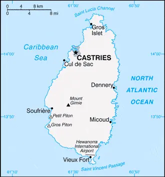
| Borderline map of Saint Lucia | Location map of Saint Lucia | Flag of Saint Lucia |
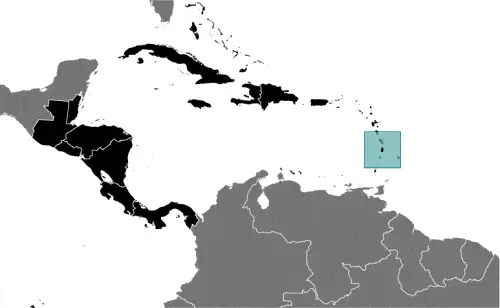
Google Maps and Detailed Facts of Saint Lucia (LC). This page lets you explore Saint Lucia and its border countries (Country Location: the Caribbean, island between the Caribbean Sea and North Atlantic Ocean, north of Trinidad and Tobago) through detailed Satellite imagery – fast and easy as never before Google Maps.
Find comprehensive information about this country’s diversity below: Google maps, geography, economy, science, people, culture, environment, government, and history – All in One Wiki page.
There is also a Street View and free Driving Directions at your service. Your Google Satellite Map Sightseeing in Saint Lucia, in Central America, and the Caribbean, starts here at Driving Directions and Maps.com.
Saint Lucia Google Maps & Satellite Maps
The map below shows Saint Lucia with its cities, towns, highways, main roads, streets, and Street Views. To find a location, use the form below, type any city or place, view a simple map, and click the “show map” button.
The Google map above shows Saint Lucia with its location: Central America, and the Caribbean (geographic coordinates: 13 53 N, 60 58 W) and the international borders of Saint Lucia; 0 km; furthermore, it’s inland counties boundaries.
Hint: Look at the Street view in Saint Lucia, or Central America, and the Caribbean. All you have to do is drag and pull the little yellow man (named: Pegman) on the Google map above the desired location. After that, whenever it is available (more than 50 countries globally), blue stripes will appear to show the photos and details from Google’s regularly updated data image base. In case if you have signed in to your Google account currently, you may have a look at the satellite map of this country/area as well.
The map of Saint Lucia, Central America, and the Caribbean is for informational use only. No representation is made or warrantied given any map or its content by Driving Directions and Maps site. The user assumes all risks of using this Saint Lucia Google map and facts/wiki.
About Saint Lucia in detail
Where is Saint Lucia?
Saint Lucia, in case, if you are looking on the map under the Coordinates 14 00 N 61 00 W otherwise in Central America, and the Caribbean, in the Caribbean, island between the Caribbean Sea and North Atlantic Ocean, north of Trinidad and Tobago.
What is the capital city of Saint Lucia?
The capital city of Saint Lucia is Castries.
What is the time in Castries?
It is 1 hour ahead of Washington, D.C. during Standard Time; Castries’ timezone is UTC-4.
What is the Internet code for Saint Lucia?
The Top Level Domain (TLD) for Saint Lucia is: .lc
What is the size of Saint Lucia?
The territory of Saint Lucia is 616 sq km; land: 606 sq km, water: 10 sq km.
If we want to describe the size of Saint Lucia’s territory is three and a half times the size of Washington, DC.
If we would like to walk around and discover Saint Lucia, we can cover 0 km.
What is the water coverage of Saint Lucia?
We have already mentioned what percentage of Saint Lucia is covered by water (see below), including a 158 km coastline.
What is the climate like in Saint Lucia?
Saint Lucia’s climate is tropical, moderated by northeast trade winds: dry season January to April, rainy season May to August.
Geographical data of Saint Lucia
The elevation of Saint Lucia; mean elevation: N/A, elevation extremes; lowest point: the Caribbean Sea 0 m, highest point: Mount Gimie 950 m.
The specific geographical details of Saint Lucia include volcanic and mountainous with broad, fertile valleys.
Suppose we would like to describe the countries location from a different perspective. In that case, it is safe to say, and easy to read from a map, Saint Lucia is the twin Pitons (Gros Piton and Petit Piton), striking cone-shaped peaks south of Soufriere, are one of the scenic natural highlights of the Caribbean.
Resources and land use of Saint Lucia
The country’s main mined products are forests, sandy beaches, minerals (pumice), mineral springs, geothermal potential. The population partly uses the earlier highlighted land territory and partly left in its natural state: agricultural land: 17.4%; arable land 4.9%; permanent crops 11.5%; permanent pasture 1%; forest: 77%; other: 5.6% (2011 estimate).
Population data of Saint Lucia
The number of inhabitants of Saint Lucia is 164,464 (July 2016 estimate).
If we examine the proportion of the population distribution, it is safe to say that most of the population is found on the periphery of the island, with a larger concentration in the north around the capital of Castries.
If we look at the proportion of the urbanized and barely populated areas, these are the figures: urban population: 18.5% of the total population (2015).
Most of the population in Saint Lucia is concentrated in CASTRIES (capital) 22,000 (2014).
Ethnicity in Saint Lucia
According to ethnicity details, the ethnic groups are black/African descent 85.3%, mixed 10.9%, East Indian 2.2%, other 1.6%, unspecified 0.1% (2010 estimate).
Spoken languages in Saint Lucia
The spoken languages in Saint Lucia are the following: English (official language), French patois.
What are the most important religions in Saint Lucia?
During the general census, researchers examine the churches, according to this: Roman Catholic 61.5%, Protestant 25.5% (includes Seventh Day Adventist 10.4%, Pentecostal 8.9%, Baptist 2.2%, Anglican 1.6%, Church of God 1.5%, other Protestant 0.9%), other Christian 3.4% (includes Evangelical 2.3% and Jehovah’s Witness 1.1%), Rastafarian 1.9%, other 0.4%, none 5.9%, unspecified 1.4% (2010 estimate).
Further population data of Saint Lucia
The proportion of gender and age tells a lot about the society as follows 0-14 years: 20.35% (male 17,225 / female 16,237) 15-24 years: 15.88% (male 13,257 / female 12,867) 25-54 years: 42.97% (male 33,974 / female 36,697) 55-64 years: 9.58% (male 7,278 / female 8,478) 65 years and over: 11.22% (male 8,352 / female 10,099) (2016 estimate). It also a significant factor in a society the population growth rate, which in the case of Saint Lucia is 0.33% (2016 estimate).
The population growth rate is based on two elements, the birth, and the death rate. In Saint Lucia the birth rate is 13.5 births / 1,000 population (2016 estimate), the death rate 7.6 deaths / 1,000 population (2016 estimate).
In this day and age in developed societies, the first child borns later compared to the previous centuries and decades, so childbearing is extended. In Saint Lucia, the average age of mothers at the first childbirth is N/A.
Although the children’s birth is postponed in the best-case scenario, the parents can still see their kids grow as life expectancy also extended. In the case of Saint Lucia, these figures are. With the introduction of modern medicine, vaccinations, and the proper hygienic conditions, the infant mortality rate is in a steep decline. The infant mortality statistics in Saint Lucia are the following: N/A. Relevant data is the budget of healthcare, which is in the case of this country is 6.7% of GDP (2014).
Economic data of Saint Lucia
Suppose we would like to describe a country. We also have to mention its economy; The island nation has attracted foreign business and investment, especially in its offshore banking and tourism industries. Tourism is Saint Lucia’s leading source of jobs and income – accounting for 65% of GDP. Saint Lucia is vulnerable to various external shocks, including volatile tourism receipts, natural disasters, and dependence on foreign oil. Furthermore, high public debt – 77% of GDP in 2012 – and high debt servicing obligations constrain the ANTHONSt. Since the onset of the global financial crisis in 2008, Lucia has experienced anemic growth mostly because of a slowdown in tourism – airlines cut back on their routes to St. Lucia in 2012. Also, St. Lucia introduced a value-added tax in 2012 of 15%.
GDP is a prominent figure, as all the relevant calculations and statistics are based on it. GDP in Saint Lucia is $1.439 billion (2015 estimate).
Another important indicator is the rate of GDP growth, which in Saint Lucia is 1.5% (2016 estimate), 2.4% (2015 estimate) 0.4% (2014 estimate).
These statistics affect the world economy; remember, in 2015, the Chinese real GDP growth rate was worse than expected; The world markets fall, and the Chinese stock exchange was temporarily suspended.
A further major factor of a country’s economy, the GDP per capita. In Saint Lucia this is $12,000 (2016 estimate) $11,900 (2015 estimate) $11,700 (2014 estimate).
In the economy, the Trinity is in common places, such as agriculture, industry, and services.
What are the agricultural products Saint Lucia produces?
The main agricultural products of Saint Lucia are bananas, coconuts, vegetables, citrus, root crops, cocoa.
The essential segments are tourism, clothing, assembly of electronic components, beverages, corrugated cardboard boxes, lime processing, and coconut processing. The crucial and regularly mentioned GDP is based on tourism; clothing, electronic components, beverages, corrugated cardboard boxes, lime processing, and coconut processing.
Drinking water source in Saint Lucia
It is essential to mention that – thanks to the development of the infrastructure -, the rate of potable water improved: urban: 99.5% of the population, rural: 95.6% of the population, total: 96.3% of the population. Unimproved: urban: 0.5% of the population, rural: 4.4% of the population, total: 3.7% of the population (2015 estimate).
The average number of childbirth in Saint Lucia
In Saint Lucia, the average delivery number is 1.75 children born / woman (2016 estimate).
Population, median age, migration, and citizenship in Saint Lucia
The population’s average age is 34.2 years; male: 33 years, female: 35.3 years (2016 estimate). The age of adulthood varies in every country of the world in Saint Lucia; it is 18 years of age, universal.
When we are experiencing an unprecedented scale of migration and globalization, it is an important factor in the number of new immigrants. In Saint Lucia is -2.7 migrant(s) / 1,000 population (2016 estimate). It is important to know how to apply for citizenship: citizenship by birth: yes. Citizenship by descent: at least one parent must be a citizen of Saint Lucia. Dual citizenship recognized: yes, the residency requirement for naturalization: 8 years.
Is Saint Lucia a safe destination? Healthcare services and infectious diseases in Saint Lucia
Many of the travelers are looking into the healthcare services and infectious diseases of their destinations. In Saint Lucia, the hospital beds’ density is 1.6 beds / 1,000 population (2011).
According to the WHO rating regarding contagious diseases in Saint Lucia the note: active local transmission of Zika virus by Aedes species mosquitoes has been identified in this country (as of August 2016); it poses a significant risk (a large number of cases possible) among US citizens if bitten by an infective mosquito; other less common ways to get Zika are through sex, via blood transfusion, or during pregnancy, in which the pregnant woman passes Zika virus to her fetus (2016).
However, HIV is not curable but maintainable. Let’s do not forget when the disease surfaced; it was a world threatening condition. Unfortunately, in some countries, it is still very high the number of infected patients and fatalities due to the disease.
In Saint Lucia, the number of HIV/AIDS deaths: N/A.
Regarding tourism obesity, not an important issue, but we have to mention health statistics, as it is the plague of the 20th and the 21st century. The rate of obese adults in Saint Lucia is 27% (2014).
What are the natural hazards in Saint Lucia? Is there any?
The most known natural risk in Saint Lucia are hurricanes; volcanic activity.
More interesting facts about Saint Lucia
A few words about the past, as every country and society, is connected to its history; The island, with its fine natural harbor at Castries, was contested between England and France throughout the 17th and early 18th centuries (changing possession 14 times); it was finally ceded to the UK in 1814. Even after abolishing slavery on its plantations in 1834, Saint Lucia remained an agricultural island dedicated to producing tropical commodity crops. Self-government was granted in 1967 and independence in 1979.
In every nation’s memory, some cornerstones placed the country on the timeline of history. The date of declaration of independence of Saint Lucia: 22 February 1979 (from the UK).
The flag and other symbols of Saint Lucia
The colors, symbols, and animals on the flag usually have a historical background or an important milestone or memory of the nation.
This case is not an exception either; cerulean blue with a gold isosceles triangle below a black arrowhead; the upper edges of the arrowhead have a white border; the blue color represents the sky and sea, gold stands for sunshine and prosperity, and white and black the racial composition of the island (with the latter being dominant); the two major triangles invoke the twin Pitons (Gros Piton and Petit Piton), cone-shaped volcanic plugs that are a symbol of the island.
Apart from the flag, the symbol of national unity is the national anthem. The anthem’s primary purpose is to share the nation’s core values, endeavors, and patriotic feelings.
National symbols of Saint Lucia: twin pitons (volcanic peaks), Saint Lucia parrot; national colors: cerulean blue, gold, black, white.
Constitution of Saint Lucia
The existence of the nation is based on the constitution. Some constitutions knew worldwide, like the U.S. Constitution that was accepted on the 17th of September 1787, in Philadelphia, the United States of America’s Constitution.
It is not related to the declaration of independence that was stolen by Nicolas Cage in the movie National Treasure 🙂
What is the legal system of Saint Lucia?
Most of the time, the legal system of a country is the focus of lawyers. It is a common fact that there are two main approaches in the world, “the law in books” and “the law in action.”
In the Anglo-Saxon world, the practice is the “law in action,” while in the rest of the world, the law is based on Roman law, the “law in books.”
The legal system of Saint Lucia is English common law.
It was Aristotle who founded the Theory of 3 separations of powers. In his view, these are the council of public affairs, the magistrates, and the justice system. The age of enlightenment was the time when terminologies have defined the way we still use them. In most democratic countries, the three authorities separated from each other. In dictatorships, the rules usually interweaved in one hand.
About the legislative branch of Saint Lucia, we can highlight the following structures bicameral Parliament consists of the Senate (11 seats; 6 members appointed on the advice of the prime minister, three on the guidance of the leader of the opposition, and two upon consultation with religious, economic, and social groups; members serve 5-year terms) and the House of Assembly (17 seats; members directly elected in single-seat constituencies by simple majority vote to serve 5-year terms).
About the unemployment rate, labor force, and poverty line in Saint Lucia
One of the major problems of the 21st-century economy is unemployment. Governments are struggling to maintain a low level of the unemployment rate. Still, as a result of automation, the cheap 3rd world labor, and the outsourcing of workflow, these attempts fail. In Saint Lucia, the labor force is 79,700 (2012 estimate). Please bear in mind that the population in Saint Lucia is total: 11.2 deaths / 1,000 live births; male: 10.7 deaths / 1,000 live births, female: 11.7 deaths / 1,000 live births (2016 estimate) – as we already mentioned above.
The rate of unemployment in Saint Lucia is 20% (2003 estimate).
Widely known that the gap between the rich and poor is widening on an enormous scale.
According to the 2017 shocking Oxfam report, the most affluent eight people’s fortune is equal to the wealth of the poorest half of the world’s population.
In Saint Lucia, the households’ income and consumption compared to the entire population: lowest 10%: N/A% highest 10%: N/A%.
Another widely used indicator is the so-called GINI index, which measures the inequalities of statistical dispersion, but is mainly used for measuring the sharing of income and fortune.
The GINI index was named after its founder Corrado Gini, an Italian economist. Gini index has grades between 0-1, but often it is used on a percentage basis. It is 0 if the examined criteria territorial distribution is equal. It is one of the criteria concentrated on the territory. In Saint Lucia, the GINI index is N/A.
The states usually set up a poverty line, which is more or less, is a subjective measure. It varies by country; its base is often the minimum pension, the incomes of the most deficient 20 percent, the X percent of income per capita Etc.
In Saint Lucia, the poverty line people are the lowest 10%: N/A% highest 10%: N/A%.
About the budget and central governments debt of Saint Lucia
The available budget mainly defines the state’s economy. Saint Lucia’s budget is; revenues: $185.2 million, expenditures: $222.2 million (2011 estimate). Taxes and other revenues are 12.9% of GDP (2011 estimate).
The budget deficit (Budget surplus (+) or deficit (-)) is N/A.
The fiscal year in Saint Lucia is 1 April – 31 March.
In the country’s economy, we have to consider the public debt. Public debt is the consolidated sum of the state’s local, federal, and central government debt.
Inflation rate and prime lending rate in Saint Lucia
A few further interesting and relevant economic data are the following; Inflation rate: 0.1% (2016 estimate), -1% (2015 estimate), and the rate of the Commercial bank prime lending rate: 8.8% (31 December 2016 estimate).
Export/import partners and data of Saint Lucia
Saint Lucia, with the export of products, industrial tools, and other services, generates revenue. The export value in Saint Lucia is $205.2 million (2016 estimate), $207 million (2015 estimate). The total revenue of these activities: bananas 41%, clothing, cocoa, avocados, mangoes, coconut oil (2010 estimate).
The most important export partners of Saint Lucia are the Dominican Republic 25.1%, US 15.9%, Suriname 9.1%, Antigua and Barbuda 7%, Dominica 6.8%, Trinidad and Tobago 6.3%, Barbados 6.1%, UK 4.8%, Grenada 4.6% (2015).
The most important imported products are food, manufactured goods, machinery, transportation equipment, chemicals, fuels, and the countries from where the import is coming: Brazil 34.9%, US 25.7%, Trinidad and Tobago 14.4%, Colombia 10.9% (2015).
Renewable energies used in Saint Lucia
To suppress the pollution of the environment, renewable energies have to replace the fossil energy. The more the proportion of renewable energies in a country means more effort against pollution. Saint Lucia, the indicator of how much of the country’s produced energy is coming from the hydroelectric source, is 0% of total installed capacity (2012 estimate).
To indicate how much another renewable energy produced is 0% of total installed capacity (2012 estimate).
Telecommunication data of Saint Lucia, calling code
To maintain the economy, the development of a reliable and modern telecommunications infrastructure is crucial. We can say the following about Saint Lucia; an adequate system that is automatically switched. Domestic: fixed-line teledensity is 20 per 100 persons, and mobile-cellular teledensity is roughly 115 per 100 persons. International: country code – 1-758; the East Caribbean Fiber System and Southern Caribbean Fiber submarine cables, along with Intelsat from Martinique, carry calls internationally; direct microwave radio relay link with Martinique and Saint Vincent and the Grenadines; (2015).
Transport infrastructure in Saint Lucia
In the 21st century, we often say that the world has become small and there are no distances anymore. With widespread air travel when (sometimes) there are no visa restrictions, it is easy to reach other countries, but if the distance is not too long, we can also use railway or water transportation.
The number of airports in Saint Lucia: 2 (2013), and the number of heliports: N/A.
The total length of the roadways in Saint Lucia: 1,210 km, paved: 847 km, unpaved: 363 km (2011).
The total length of the waterways in Saint Lucia: N/A.
Are you traveling to Saint Lucia?
If you plan to travel by plane to Saint Lucia, try our air ticket comparison site, where you can choose from hundreds of carriers and offers. Our application is scanning the market and shows you the best and the cheapest deals without any extra charge or commission.
Are you looking for a hotel, apartment another kind of accommodation in Saint Lucia, Central America, and the Caribbean? We are here to help you to find your accommodation from budget to luxury. Our search engine is scanning, regularly updating data from hundreds of accommodation websites and more than a million offers. You can quickly and easily find your hotel stay anywhere in the world, without any extra charge or commission.
Facts & data about Saint Lucia
Name of the country: conventional long way: none, traditional short form: Saint Lucia, etymology: named after Saint LUCY of Syracuse by French sailors who were shipwrecked on the island on 13 December 1502, the saint’s feast day.
| Abbreviation: Saint Lucia | Geographic coordinates: 13 53 N, 60 58 W |
Country Location: Central America, and the Caribbean |
| Capital of Saint Lucia: Castries | GPS of the Capital: 14 00 N 61 00 W |
Position: Caribbean, island between the Caribbean Sea and North Atlantic Ocean, north of Trinidad and Tobago |
| Land area: total: 616 sq km; land: 606 sq km, water: 10 sq km | Terrain: volcanic and mountainous with broad, fertile valleys |
Area comparative: three and a half times the size of Washington, DC |
| Population: 164,464 (July 2016 estimate) | Population grow rate: 0.33% (2016 estimate) | Sex ratio: at birth: 1.06 male(s) / female, 0-14 years: 1.06 male(s) / female, 15-24 years: 1.03 male(s) / female, 25-54 years: 0.93 male(s) / female, 55-64 years: 0.86 male(s) / female, 65 years and over: 0.83 male(s) / female, total population: 0.95 male(s) / female (2016 estimate) |
| Exports: $205.2 million (2016 estimate), $207 million (2015 estimate) | Imports: $532 million (2016 estimate), $540.6 million (2015 estimate) | Import partners: Brazil 34.9%, US 25.7%, Trinidad and Tobago 14.4%, Colombia 10.9% (2015) |
| Urbanization: urban population: 18.5% of the total population (2015) | Major urban area(s): CASTRIES (capital) 22,000 (2014) | Median age: total: 34.2 years; male: 33 years, female: 35.3 years (2016 estimate) |
| Internet users: total: 86,000. Percent of the population: 52.4% (July 2015 estimate) | Telephones (fixed-lines): total subscriptions: 34,874. Subscriptions per 100 inhabitants: 21 (July 2015 estimate) | Telephones (mobile, cellular): total: 188,000. Subscriptions per 100 inhabitants: 115 (July 2015 estimate) |
| Unemployment rate: 20% (2003 estimate) | Nationality: Saint Lucian(s) adjective: Saint Lucian | National holidays: Independence Day, 22 February (1979) |
| Life expectancy at birth: total population: 77.8 years. Male: 75 years, female: 80.7 years (2016 estimate) | Total fertility rate: 1.75 children born / woman (2016 estimate) | Birthrate: 13.5 births / 1,000 population (2016 estimate) |
| Literacy: N/A | Legal system: English common law | Suffrage: 18 years of age, universal |
| Industries: tourism; clothing, assembly of electronic components, beverages, corrugated cardboard boxes, lime processing, coconut processing | Industrial production growth rate: 4% (2016 estimate) | GDP real growth rate: 1.5% (2016 estimate) 2.4% (2015 estimate) 0.4% (2014 estimate) |
Do you like this Saint Lucia Google maps™ & country information page?
Please do us a favor: Share or like this page using the icons at the top of the page. We also do encourage you to visit our Facebook page for more travel and country related information.
Many thanks for visiting and sharing this map & country information site!