
 |
 |
 |
| Borderline map of Saint Helena | Location map of Saint Helena | Flag of Saint Helena |
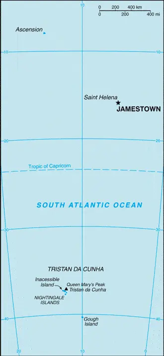
Google Maps and Detailed Facts of Saint Helena (SH). This page lets you explore Saint Helena and its border countries (Country Location: islands in the South Atlantic Ocean, about midway between South America and Africa; Ascension Island lies 1,300 km (800 mi) northwest of Saint Helena; Tristan da Cunha lies 4,300 km (2,700 mi) southwest of Saint Helena) through detailed Satellite imagery – fast and easy as never before Google Maps.
Find comprehensive information about this country’s diversity below: Google maps, geography, economy, science, people, culture, environment, government, and history – All in One Wiki page.
There is also a Street View and free Driving Directions at your service. Your Google Satellite Map Sightseeing in Saint Helena, in Africa, starts here at Driving Directions and Maps.com.
Saint Helena Google Maps & Satellite Maps
The map below shows Saint Helena with its cities, towns, highways, main roads, streets, and Street Views. To find a location, use the form below, type any city or place, view a simple map, and click the “show map” button.
The Google map above shows Saint Helena with its location: Africa (geographic coordinates: 15 57 S, 5 42 W) and the international borders of Saint Helena; 0 km; furthermore, it’s inland counties boundaries.
Hint: Look at the Street view in Saint Helena, or Africa. All you have to do is drag and pull the little yellow man (named: Pegman) on the Google map above the desired location. After that, whenever it is available (more than 50 countries globally), blue stripes will appear to show the photos and details from Google’s regularly updated data image base. In case if you have signed in to your Google account currently, you may have a look at the satellite map of this country/area as well.
The map of Saint Helena, Africa, is for informational use only. No representation is made or warrantied given any map or its content by Driving Directions and Maps site. The user assumes all risks of using this Saint Helena Google map and facts/wiki.
About Saint Helena in detail
Where is Saint Helena?
Saint Helena, in case, if you are looking on the map under the Coordinates 15 56 S 5 43 W otherwise in Africa, in islands in the South Atlantic Ocean, about midway between South America and Africa; Ascension Island lies 1,300 km (800 mi) northwest of Saint Helena; Tristan da Cunha lies 4,300 km (2,700 mi) southwest of Saint Helena.
What is the capital city of Saint Helena?
The capital city of Saint Helena is Jamestown.
What is the time in Jamestown?
It is 5 hours ahead of Washington, D.C. during Standard Time; Jamestown’s timezone is UTC 0.
What is the Internet code for Saint Helena?
The Top Level Domain (TLD) for Saint Helena is: .sh
What is the size of Saint Helena?
The territory of Saint Helena is 308 sq km; land: 308 sq km, water: 0 sq km.
If we want to describe the size of the territory of Saint Helena is slightly more than twice the size of Washington, DC.
If we would like to walk around and discover Saint Helena, we can cover 0 km.
What is the water coverage of Saint Helena?
We have already mentioned what percentage of Saint Helena is covered by water (see below), and this includes Saint Helena: 60 km, Ascension Island: NA, Tristan da Cunha: 40 km coastline.
What is the climate like in Saint Helena?
The climate of Saint Helena in Saint Helena: tropical marine: mild, tempered by trade winds. Ascension Island: tropical marine: mild, semi-amid. Tristan da Cunha: temperate marine: mild, tempered by trade winds (tends to be cooler than Saint Helena).
Geographical data of Saint Helena
The elevation of Saint Helena; mean elevation: N/A, elevation extremes; lowest point: Atlantic Ocean 0 m, highest point: Queen Mary’s Peak on Tristan da Cunha 2,060 m.
The specific geographical details of Saint Helena include the islands of this group are of volcanic origin associated with the Atlantic Mid-Ocean RidgeSaint Helena: rugged, volcanic; small scattered plateaus and plainsAscension: surface covered by lava flows and cinder cones of 44 dormant volcanoes; terrain rises to the eastTristan da Cunha: sheer cliffs line the coastline of the nearly circular island; the flanks of the central volcanic peak are deeply dissected; narrow coastal plain lies between The Peak and the coastal cliffs.
Suppose we would like to describe the countries location from a different perspective. In that case, it is safe to say, and easy to read from a map, Saint Helena is Saint Helena harbors at least 40 species of plants unknown elsewhere in the world; Ascension is a breeding ground for sea turtles and sooty terns; Queen Mary’s Peak on Tristan da Cunha is the highest island mountain in the South Atlantic and a prominent landmark on the sea lanes around southern Africa.
Resources and land use of Saint Helena
The country’s main mined products are fish, lobster. The population partly uses the earlier highlighted land territory and partly left in its natural state: agricultural land: 30.8%; arable land 10.3%; permanent crops 0%; permanent pasture 20.5%; forest: 5.1%; other: 64.1% (2011 estimate).
Population data of Saint Helena
The number of inhabitants of Saint Helena is 7,795 (July 2016 estimate).
If we examine the proportion of the population distribution, it is safe to say that N/A.
If we look at the proportion of the urbanized and barely populated areas, these are the figures: urban population: 39.4% of the total population (2015).
Most of the population in Saint Helena is concentrated in JAMESTOWN (capital) 1,000 (2014).
Ethnicity in Saint Helena
According to ethnicity details, the ethnic groups are of African descent 50%, white 25%, Chinese 25%.
Spoken languages in Saint Helena
The spoken languages in Saint Helena are the following: English.
What are the most important religions in Saint Helena?
During the general census, researchers examine the churches, according to this: Protestant 75.9% (includes Anglican 68.9, Baptist 2.1%, Seventh Day Adventist 1.8%, Salvation Army 1.7%, New Apostolic 1.4%), Jehovah’s Witness 4.1%, Roman Catholic 1.2%, other 2.5% (includes Baha’i), unspecified 0.8%, none 6.1%, no response 9.4%note: data represent Saint Helena only (2016 estimate).
Further population data of Saint Helena
The proportion of gender and age tells a lot about the society as follows 0-14 years: 16.27% (male 647 / female 624) 15-24 years: 12.12% (male 484 / female 463) 25-54 years: 44.27% (male 1,709 / female 1,750) 55-64 years: 12.72% (male 519 / female 475) 65 years and over: 14.62% (male 582 / female 560) (2016 estimate). It also a significant factor in a society the population growth rate, which in the case of Saint Helena is 0.21% (2016 estimate).
The population growth rate is based on two elements, the birth and the death rate. In Saint Helena the birth rate is 9.7 births / 1,000 population (2016 estimate), the death rate 7.7 deaths / 1,000 population (2016 estimate).
In this day and age in developed societies, the first child borns later compared to the previous centuries and decades, so childbearing is extended. In Saint Helena, the average age of mothers at the first childbirth is N/A.
Although the children’s birth is postponed in the best-case scenario, the parents can still see their kids grow as life expectancy also extended. In the case of Saint Helena, these figures are. With the introduction of modern medicine, vaccinations, and the proper hygienic conditions, the infant mortality rate is in a steep decline. The infant mortality statistics in Saint Helena are the following: N/A. Relevant data is the budget of healthcare, which is in the case of this country is N/A.
Economic data of Saint Helena
Suppose we would like to describe a country. We also have to mention its economy; The economy depends largely on financial assistance from the UK, which amounted to about $27 million in FY06/07 or more than twice the annual budgetary revenues level. The local population earns income from fishing, raising livestock, and sales of hand.
GDP is a prominent figure, as all the relevant calculations and statistics are based on it. GDP in Saint Helena is $NA.
Another important indicator is the rate of GDP growth, which in Saint Helena is N/A%.
These statistics affect the world economy; remember, in 2015, the Chinese real GDP growth rate was worse than expected; The world markets fall, and the Chinese stock exchange was temporarily suspended.
A further major factor of a country’s economy, the GDP per capita. In Saint Helena, this is $7,800 (FY09/10 estimate).
In the economy, the Trinity is in common places, such as agriculture, industry, and services.
What are the agricultural products Saint Helena produces?
The main agricultural products of Saint Helena are coffee, corn, potatoes, vegetables, fish, lobster, livestock, timber.
Regarding the economy, the essential segments are construction, crafts (furniture, lacework, fancy woodwork), fishing, collectible postage stamps. The crucial and regularly mentioned GDP is based on construction, crafts (furniture, lacework, fancy woodwork), fishing, collectible postage stamps.
Drinking water source in Saint Helena
It is essential to mention that – thanks to the infrastructure development– the rate of potable water N/A.
The average number of childbirth in Saint Helena
In Saint Helena, the average delivery number is 1.58 children born / woman (2016 estimate).
Population, median age, migration, and citizenship in Saint Helena
The population’s average age is 41.5 years; male: 41.5 years, female: 41.4 years (2016 estimate). The age of adulthood varies in every country of the world in Saint Helena; it is 18 years of age.
When we are experiencing an unprecedented scale of migration and globalization, it is an important factor in the number of new immigrants. In Saint Helena is 0 migrant(s) / 1,000 population (2016 estimate). It is important to know how to apply for citizenship: see the United Kingdom.
Is Saint Helena a safe destination? Healthcare services and infectious diseases in Saint Helena
Many of the travelers are looking into the healthcare services and infectious diseases of their destinations. In Saint Helena, the hospital beds’ density is N/A.
According to the WHO rating regarding contagious diseases in Saint Helena: N/A.
However, HIV is not curable but maintainable. Let’s do not forget when the disease surfaced; it was a world threatening condition. Unfortunately, in some countries, it is still very high the number of infected patients and fatalities due to the disease.
In Saint Helena, the number of HIV/AIDS deaths: N/A.
Regarding tourism obesity, not an important issue, but we have to mention health statistics, as it is the plague of the 20th and the 21st century. The rate of obese adults in Saint Helena is N/A.
What are the natural hazards in Saint Helena? Is there any?
The most known natural risk in Saint Helena is active volcanism on Tristan da Cunhavolcanism: the island volcanoes of Tristan da Cunha (elevation 2,060 m) and Nightingale Island (height 365 m) experience volcanic activity; Tristan da Cunha erupted in 1962 and Nightingale in 2004.
More interesting facts about Saint Helena
A few words about the past, as every country and society, is connected to its history; Saint Helena is a British Overseas Territory consisting of Saint Helena and Ascension Islands, and the island group of Tristan da Cunha.
Saint Helena: Uninhabited when first discovered by the Portuguese in 1502, Saint Helena was garrisoned by the British during the 17th century. It acquired fame as the place of Napoleon BONAPARTE’s exile from 1815 until he died in 1821, but its importance as a port of call declined after the Suez Canal opening in 1869. During the Anglo-Boer War in South Africa, several thousand Boer prisoners were confined on the island between 1900 and 1903.
Ascension Island: This barren and uninhabited island was discovered and named by the Portuguese in 1503. The British garrisoned the island in 1815 to prevent a rescue of Napoleon from Saint Helena. It served as a provisioning station for the Royal Navy’s West Africa Squadron on anti-slavery patrol. The island remained under Admiralty control until 1922 when it became a dependency of Saint Helena. During World War II, the UK permitted the US to construct an airfield on Ascension in support of transatlantic flights to Africa and anti-submarine operations in the South Atlantic.
In the 1960s, the island became an important space tracking station for the US. In 1982, Ascension was a critical staging area for British forces during the Falklands War. It remains a critical refueling point in the air-bridge from the UK to the South Atlantic. The island hosts one of four dedicated ground antennas (the others are on Diego Garcia (British Indian Ocean Territory), Kwajalein (Marshall Islands), and at Cape Canaveral, Florida (US)) that assist in the operation of the Global Positioning System (GPS) navigation system. NASA and the US Air Force also operate a Meter-Class Autonomous Telescope (MCAT) on Ascension as part of the deep space surveillance system for tracking orbital debris, which can be a hazard to spacecraft and astronauts.
Tristan da Cunha: The island group consists of Tristan da Cunha, Nightingale, Inaccessible, and Gough Islands. Tristan da Cunha is named after its Portuguese discoverer (1506); it was garrisoned by the British in 1816 to prevent any attempt to rescue Napoleon from Saint Helena. Gough and Inaccessible Islands have been designated World Heritage Sites. South Africa leases a site for a meteorological station on Gough Island.
In every nation’s memory, some cornerstones placed the country on the timeline of history. The date of declaration of independence of Saint Helena: none (overseas territory of the UK).
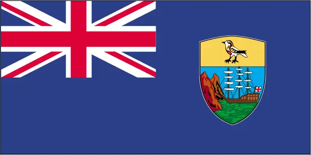
The flag and other symbols of Saint Helena
The colors, symbols, and animals on the flag usually have a historical background or an important milestone or memory of the nation.
This case is not an exception either; blue with the flag of the UK in the upper hoist-side quadrant and the Saint Helenian shield centered on the outer half of the flag; the upper third of the shield depicts a white plover (wire bird) on a yellow field; the remainder of the shield depicts a rocky coastline on the left, offshore is a three-masted sailing ship with sails furled but flying an English flag.
Apart from the flag, the symbol of national unity is the national anthem. The anthem’s primary purpose is to share the nation’s core values, endeavors, and patriotic feelings.
National symbols of Saint Helena: Saint Helena plover (bird).
Constitution of Saint Helena
The existence of the nation is based on the constitution. Some constitutions knew worldwide, like the U.S. Constitution that was accepted on the 17th of September 1787, in Philadelphia, the United States of America’s Constitution.
It is not related to the declaration of independence that was stolen by Nicolas Cage in the movie National Treasure 🙂
What is the legal system of Saint Helena?
Most of the time, the legal system of a country is the focus of lawyers. It is a common fact that there are two main approaches in the world, “the law in books” and “the law in action.”
In the Anglo-Saxon world, the practice is the “law in action,” while in the rest of the world, the law is based on Roman law, the “law in books.”
The legal system of Saint Helena is English common law and local statutes.
It was Aristotle who founded the Theory of 3 separations of powers. In his view, these are the council of public affairs, the magistrates, and the justice system. The age of enlightenment was the time when terminologies have defined the way we still use them. In most democratic countries, the three authorities separated from each other. In dictatorships, the rules usually interweaved in one hand.
About the legislative branch of Saint Helena, we can highlight the following structures unicameral Legislative Council (17 seats including the speaker and deputy speaker; 12 members directly elected in a single countrywide constituency by simple majority vote and three ex-officio members – the chief secretary, financial secretary, and attorney general; members serve 4-year terms).
About the unemployment rate, labor force, and poverty line in Saint Helena
One of the major problems of the 21st-century economy is unemployment. Governments are struggling to maintain a low level of the unemployment rate. Still, as a result of automation, the cheap 3rd world labor, and the outsourcing of workflow, these attempts fail. In Saint Helena, the labor force is 2,486 (1998 estimate). Please bear in mind that the population in Saint Helena is total: 13.7 deaths / 1,000 live births; male: 16.2 deaths / 1,000 live births, female: 11.1 deaths / 1,000 live births (2016 estimate) – as we already mentioned above.
The rate of unemployment in Saint Helena is 14% (1998 estimate).
Widely known that the gap between the rich and poor is widening on an enormous scale.
According to the 2017 shocking Oxfam report, the most affluent eight people’s fortune is equal to the wealth of the poorest half of the world’s population.
In Saint Helena, the households’ income and consumption compared to the entire population: lowest 10%: N/A% highest 10%: N/A%.
Another widely used indicator is the so-called GINI index, which measures the inequalities of statistical dispersion, but is mainly used for measuring the sharing of income and fortune.
The GINI index was named after its founder Corrado Gini, an Italian economist. Gini index has grades between 0-1, but often it is used on a percentage basis. It is 0 if the examined criteria territorial distribution is equal. It is one of the criteria concentrated on the territory. In Saint Helena, the GINI index is N/A.
The states usually set up a poverty line, which is more or less, is a subjective measure. It varies by country; its base is often the minimum pension, the incomes of the most deficient 20 percent, the X percent of income per capita Etc.
In Saint Helena, the poverty line people are the lowest 10%: N/A% highest 10%: N/A%.
About the budget and central governments debt of Saint Helena
The available budget mainly defines the state’s economy. The budget of Saint Helena is; revenues: $8.845 million, expenditures: $21.73 million. Note: revenue data reflect locally raised revenues only; the budget deficit is resolved by grant aid from the UK (FY06/07 estimate). Taxes and other revenues are N/A.
The budget deficit (Budget surplus (+) or deficit (-)) is N/A.
The fiscal year in Saint Helena is 1 April – 31 March.
In the country’s economy, we have to consider the public debt. Public debt is the consolidated sum of the state’s local, federal, and central government debt.
Inflation rate and prime lending rate in Saint Helena
A few further interesting and relevant economic data are the following; Inflation rate: 4% (2012 estimate) and the commercial bank prime lending rate: N/A.
Export/import partners and data of Saint Helena
Saint Helena, with the export of products, industrial tools, and other services, generates revenue. The export value in Saint Helena is $19 million (2004 estimate). The total revenue of these activities: fish (frozen, canned, and salt-dried skipjack, tuna), coffee, handicrafts.
The most important export partners of Saint Helena are N/A.
The most important imported products are food, beverages, tobacco, fuel oils, animal feed, building materials, motor vehicles and parts, machinery and parts, and the countries from where the import is coming: N/A.
Renewable energies used in Saint Helena
To suppress the pollution of the environment, renewable energies have to replace the fossil energy. The more the proportion of renewable energies in a country means more effort against pollution. Saint Helena, the indicator of how much of the country’s produced energy is coming from the hydroelectric source, is 0% of total installed capacity (2012 estimate).
To indicate how much another renewable energy produced is 0% of total installed capacity (2012 estimate).
Telecommunication data of Saint Helena, calling code
To maintain the economy, the development of a reliable and modern telecommunications infrastructure is crucial. We can say the following about Saint Helena; it can communicate worldwide. Domestic: automatic digital network. International: country code (Saint Helena) – 290 (Ascension Island) – 247; International direct dialing; satellite voice and data communications. Satellite earth stations – 5 (Ascension Island – 4, Saint Helena – 1) (2010).
Transport infrastructure in Saint Helena
In the 21st century, we often say that the world has become small and there are no distances anymore. With widespread air travel when (sometimes) there are no visa restrictions, it is easy to reach other countries, but if the distance is not too long, we can also use railway or water transportation.
The number of airports in Saint Helena: 2 (2015), and the number of heliports: N/A.
The total length of the roadways in Saint Helena: total: 198 km (Saint Helena 138 km, Ascension 40 km, Tristan da Cunha 20 km)paved: 168 km (Saint Helena 118 km, Ascension 40 km, Tristan da Cunha 10 km), unpaved: 30 km (Saint Helena 20 km, Tristan da Cunha 10 km) (2002).
The total length of the waterways in Saint Helena: N/A.
Are you traveling to Saint Helena?
If you plan to travel by plane to Saint Helena, try our air ticket comparison site, where you can choose from hundreds of carriers and offers. Our application is scanning the market and shows you the best and the cheapest deals without any extra charge or commission.
Are you looking for a hotel, apartment another kind of accommodation in Saint Helena, Africa? We are here to help you to find your accommodation from budget to luxury. Our search engine is scanning, regularly updating data from hundreds of accommodation websites and more than a million offers. You can quickly and easily find your hotel stay anywhere in the world, without any extra charge or commission.
Facts & data about Saint Helena
Name of the country: conventional long way: Saint Helena, Ascension, and Tristan da Cunha, traditional short form: none, etymology: Saint Helena was discovered in 1502 by Galician navigator Joao da NOVA, sailing in the service of the Kingdom of Portugal, who named it “Santa Helena”; Ascension was named in 1503 by Portuguese navigator Afonso de ALBUQUERQUE who sighted the island on the Feast Day of the Ascension; Tristan da Cunha was discovered in 1506 by Portuguese explorer Tristao da CUNHA who christened the main island after himself (the name was subsequently anglicized).
| Abbreviation: Saint Helena | Geographic coordinates: 15 57 S, 5 42 W |
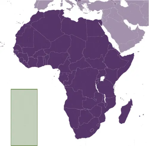
Country Location: Africa |
| Capital of Saint Helena: Jamestown | GPS of the Capital: 15 56 S 5 43 W |
Position: islands in the South Atlantic Ocean, about midway between South America and Africa; Ascension Island lies 1,300 km (800 mi) northwest of Saint Helena; Tristan da Cunha lies 4,300 km (2,700 mi) southwest of Saint Helena |
| Land area: total: 308 sq km; land: 308 sq km, water: 0 sq km | Terrain: the islands of this group are of volcanic origin associated with the Atlantic Mid-Ocean RidgeSaint Helena: rugged, volcanic; small scattered plateaus and plainsAscension: surface covered by lava flows and cinder cones of 44 dormant volcanoes; terrain rises to the eastTristan da Cunha: sheer cliffs line the coastline of the nearly circular island; the flanks of the central volcanic peak are deeply dissected; narrow coastal plain lies between The Peak and the coastal cliffs |
Area comparative: slightly more than twice the size of Washington, DC |
| Population: 7,795 (July 2016 estimate) | Population grow rate: 0.21% (2016 estimate) | Sex ratio: at birth: 1.05 male(s) / female, 0-14 years: 1.04 male(s) / female, 15-24 years: 1.05 male(s) / female, 25-54 years: 0.98 male(s) / female, 55-64 years: 1.09 male(s) / female, 65 years and over: 1.04 male(s) / female, total population: 1.02 male(s) / female (2016 estimate) |
| Exports: $19 million (2004 estimate) | Imports: $20.53 million (2010 estimate) | Import partners: N/A |
| Urbanization: urban population: 39.4% of the total population (2015) | Major urban area(s): JAMESTOWN (capital) 1,000 (2014) | Median age: total: 41.5 years; male: 41.5 years, female: 41.4 years (2016 estimate) |
| Internet users: total: 1,800. Percent of the population: 23.1% (July 2015 estimate) | Telephones (fixed-lines): total subscriptions: 2,728. Subscriptions per 100 inhabitants: 35 (July 2015 estimate) | Telephones (mobile, cellular): total: 1,267subscriptions per 100 inhabitants: (July 2015 estimate) |
| Unemployment rate: 14% (1998 estimate) | Nationality: Saint Helenian(s) adjective: Saint Helenian. Note: referred to locally as “Saints.” | National holidays: Birthday of Queen ELIZABETH II, third Monday in April (1926) |
| Life expectancy at birth: total population: 79.5 years. Male: 76.6 years, female: 82.6 years (2016 estimate) | Total fertility rate: 1.58 children born / woman (2016 estimate) | Birthrate: 9.7 births / 1,000 population (2016 estimate) |
| Literacy: N/A | Legal system: English common law and local statutes | Suffrage: 18 years of age |
| Industries: construction, crafts (furniture, lacework, fancy woodwork), fishing, collectible postage stamps | Industrial production growth rate: N/A % | GDP real growth rate: N/A% |
Do you like this Saint Helena Google maps™ & country information page?
Please do us a favor: Share or like this page using the icons at the top of the page. We also do encourage you to visit our Facebook page for more travel and country related information.
Many thanks for visiting and sharing this map & country information site!