
 |
 |
 |
| Borderline map of Namibia | Location map of Namibia | Flag of Namibia |
Google Maps and Detailed Facts of Namibia (NA). This page lets you explore Namibia and its border countries (Country Location: Southern Africa, bordering the South Atlantic Ocean, between Angola and South Africa) through detailed Satellite imagery – fast and easy as never before Google Maps.
Find comprehensive information about this country’s diversity below: Google maps, geography, economy, science, people, culture, environment, government, and history – All in One Wiki page.
There is also a Street View and free Driving Directions at your service. Your Google Satellite Map Sightseeing in Namibia, in Africa, starts here at Driving Directions and Maps.com.
Namibia Google Maps & Satellite Maps
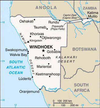
The map below shows Namibia with its cities, towns, highways, main roads, streets, and Street Views. To find a location, use the form below, type any city or place, view a simple map, and click the “show map” button.
The Google map above shows Namibia with its location: Africa (geographic coordinates: 22 00 S, 17 00 E) and the international borders of Namibia; total: 4,220 km. Border countries (total: 4): Angola 1,427 km, Botswana 1,544 km, South Africa 1,005 km, Zambia 244 km; furthermore, it’s inland counties boundaries.
Hint: Look at the Street view in Namibia, or Africa. All you have to do is drag and pull the little yellow man (named: Pegman) on the Google map above the desired location. After that, whenever it is available (more than 50 countries globally), blue stripes will appear to show the photos and details from Google’s regularly updated data image base. In case if you have signed in to your Google account currently, you may have a look at the satellite map of this country/area as well.
The map of Namibia, Africa, is for informational use only. No representation is made or warrantied given any map or its content by Driving Directions and Maps site. The user assumes all risks of using this Namibia Google map and facts/wiki.
About Namibia in detail
Where is Namibia?
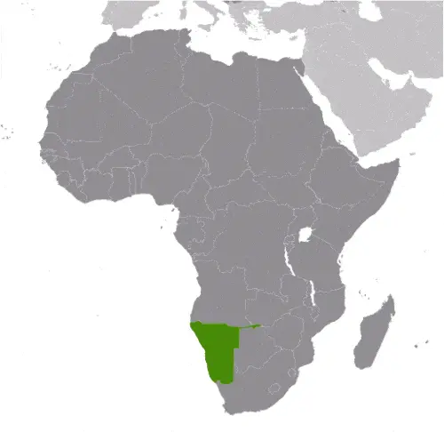
In case, Namibia is looking on the map under the Coordinates 22 34 S 17 05 E otherwise in Africa, in Southern Africa, bordering the South Atlantic Ocean, between Angola and South Africa.
What is the capital city of Namibia?
The capital city of Namibia is Windhoek.
What is the time in Windhoek?
It is 6 hours ahead of Washington, D.C. during Standard Time; Windhoek’s timezone is UTC+1.
What is the Internet code for Namibia?
The Top Level Domain (TLD) for Namibia is: .na
What is the size of Namibia?
The territory of Namibia is total: 824,292 sq km; land: 823,290 sq km, water: 1,002 sq km.
If we want to describe the size of Namibia’s territory is slightly more than half the size of Alaska.
If we would like to walk around and discover Namibia, we can cover a total distance: 4,220 km.
What is the water coverage of Namibia?
We have already mentioned what percentage of Namibia is covered by water (see below), and this includes 1,572 km coastline.
What is the climate like in Namibia?
The climate of Namibia is desert: hot, dry: rainfall sparse and erratic.
Geographical data of Namibia
Namibia’s elevation; mean elevation: 1,141 m, elevation extremes; lowest point: Atlantic Ocean 0 m, highest point: Konigstein 2,606 m.
Namibia’s specific geographical details include mostly high plateau, the Namib Desert along the coast, the Kalahari Desert in the east.
Suppose we would like to describe the countries location from a different perspective. In that case, it is safe to say, and easy to read from a map, Namibia is the first country in the world to incorporate the protection of the environment into its constitution; some 14% of the land is protected, including virtually the entire Namib Desert coastal strip.
Resources and land use of Namibia
The country’s main mined products are diamonds, copper, uranium, gold, silver, lead, tin, lithium, cadmium, tungsten, zinc, salt, hydropower, fish. Note suspected deposits of oil, coal, and iron ore. The population partly uses the earlier highlighted land territory and partly left in its natural state: agricultural land: 47.2%; arable land 1%; permanent crops 0%; permanent pasture 46.2%; forest: 8.8%; other: 44% (2011 estimate).
Population data of Namibia
The number of inhabitants of Namibia is 2,436,469 (July 2016 estimate).
If we examine the proportion of the population distribution, it is safe to say that N/A.
If we look at the proportion of the urbanized and barely populated areas, these are the figures: urban population: 46.7% of the total population (2015).
Most of the population in Namibia is concentrated in WINDHOEK (capital) 368,000 (2015).
Ethnicity in Namibia
According to ethnicity details, the ethnic groups are black 87.5%, white 6%, mixed 6.5%note: about 50% of the population belong to the Ovambo tribe and 9% to the Kavangos tribe; other ethnic groups include Herero 7%, Damara 7%, Nama 5%, Caprivian 4%, Bushmen 3%, Baster 2%, Tswana 0.5%.
Spoken languages in Namibia
The spoken languages in Namibia are the following: Oshiwambo languages 48.9%, Nama/Damara 11.3%, Afrikaans 10.4% (the common language of most of the population and about 60% of the white people), Otjiherero languages 8.6%, Kavango languages 8.5%, Caprivi languages 4.8%, English (official language) 3.4%, other African languages 2.3%, additional 1.7%. Note: Namibia has 13 recognized national languages, including ten indigenous African languages and 3 Indo-European languages (2011 estimate).
What are the most important religions in Namibia?
During the general census, researchers examine the churches, according to this: Christian 80% to 90% (at least 50% Lutheran), indigenous beliefs 10% to 20%.
Further population data of Namibia
The proportion of gender and age tells a lot about the society as follows 0-14 years: 37.39% (male 460,016 / female 451,058) 15-24 years: 20.35% (male 246,266 / female 249,570) 25-54 years: 34% (male 395,417 / female 432,994) 55-64 years: 4.25% (male 46,769 / female 56,798) 65 years and over: 4.01% (male 41,518 / female 56,063) (2016 estimate). It also a significant factor in a society the population growth rate, which in the case of Namibia is 1.98% (2016 estimate).
The population growth rate is based on two elements, the birth, and the death rate. In Namibia the birth rate is 27.9 births / 1,000 population (2016 estimate), the death rate 8.1 deaths / 1,000 population (2016 estimate).
In this day and age in developed societies, the first child borns later compared to the previous centuries and decades, so childbearing is extended. In Namibia, the average age of mothers at the first childbirth is N/A.
Although the children’s birth is postponed in the best-case scenario, the parents can still see their kids grow as life expectancy also extended. In the case of Namibia, these figures are. With the introduction of modern medicine, vaccinations, and the proper hygienic conditions, the infant mortality rate is in a steep decline. The infant mortality statistics in Namibia are the following: N/A. Relevant data is the budget of healthcare, which is in the case of this country is 8.9% of GDP (2014).
Economic data of Namibia
Suppose we would like to describe a country, we also have to mention its economy; The economy is heavily dependent on the extraction and processing of minerals for export. Mining accounts for 11.5% of GDP but provides more than 50% of foreign exchange earnings. Rich alluvial diamond deposits make Namibia a primary source for gem-qualiNamibia is the world’s fifth-largest producer of uranium. The Chinese-owned Husab uranium mine is expected to start producing uranium ore in 2017. Once the Husab mine reaches full production, Namibia is expected to become the world’s second-largest uranium producer. Namibia usually imports about 50% of its cereal requirements; in drought years, food shortages can be a problem in rural areas. A high per capita GDP, relative to the region, hides one of the world’s most unequal income distributions. A five-year Millennium Challenge Corporation compact ended in September 2014. As an upper-middle-income country, Namibia is ineligible for a second compact. The Namibian economy is closely linked to South Africa, with the Namibian dollar pegged one-to-one.
GDP is a prominent figure, as all the relevant calculations and statistics are based on it. GDP in Namibia is $10.18 billion (2015 estimate).
Another important indicator is the rate of GDP growth, which in Namibia is 4.2% (2016 estimate), 5.3% (2015 estimate) 6.5% (2014 estimate).
These statistics affect the world economy; remember, in 2015, the Chinese real GDP growth rate was worse than expected; The world markets fall, and the Chinese stock exchange was temporarily suspended.
A further major factor of a country’s economy, the GDP per capita. In Namibia this is $11,800 (2016 estimate) $11,400 (2015 estimate) $11,000 (2014 estimate).
In the economy, the Trinity is in common places, such as agriculture, industry, and services.
What are the agricultural products Namibia produces?
The main agricultural products of Namibia are millet, sorghum, peanuts, grapes; livestock; fish.
The crucial segments are meatpacking, fish processing, dairy products, pasta, beverages, mining (diamonds, lead, zinc, tin, silver, tungsten, uranium, copper). The crucial and regularly mentioned GDP is based on meatpacking, fish processing, dairy products, pasta, beverages, mining (diamonds, lead, zinc, tin, silver, tungsten, uranium, copper).
Drinking water source in Namibia
It is essential to mention that – thanks to the development of the infrastructure -, the rate of potable water improved: urban: 98.2% of the population, rural: 84.6% of the population, total: 91% of the population. Unimproved: urban: 1.8% of the population, rural: 15.4% of the people, total: 9% of the population (2015 estimate).
The average number of childbirth in Namibia
In Namibia, the average delivery number is 3.36 children born / woman (2016 estimate).
Population, median age, migration, and citizenship in Namibia
The population’s average age is 21 years; male: 20.2 years, female: 21.7 years (2016 estimate). The age of adulthood varies in every country of the world in Namibia; it is 18 years of age, universal.
When we are experiencing an unprecedented scale of migration and globalization, it is an important factor in the number of new immigrants. In Namibia is 0 migrant(s) / 1,000 population (2016 estimate). It is important to know how to apply for citizenship: citizenship by birth: no. Citizenship by descent only: at least one parent must be a citizen of Namibia. Dual citizenship recognized: no—the residency requirement for naturalization: 5 years.
Is Namibia a safe destination? Healthcare services and infectious diseases in Namibia
Many of the travelers are looking into the healthcare services and infectious diseases of their destinations. In Namibia, the hospital beds’ density is 2.7 beds / 1,000 population (2009).
According to the WHO rating regarding contagious diseases in Namibia, the degree of risk: high food or waterborne diseases: bacterial diarrhea, hepatitis A, and typhoid fever vectorborne disease: malaria. Water contact disease: schistosomiasis, (2016).
However, HIV is not curable but maintainable. Let’s do not forget when the disease surfaced; it was a world threatening condition. Unfortunately, in some countries, it is still very high the number of infected patients and fatalities due to the disease.
In Namibia, the number of HIV/AIDS deaths: N/A.
Regarding tourism obesity, not an important issue, but we have to mention health statistics, as it is the plague of the 20th and the 21st century. The rate of obese adults in Namibia is 16.8% (2014).
What are the natural hazards in Namibia? Is there any?
The most known natural risk in Namibia is prolonged periods of drought.
More interesting facts about Namibia
A few words about the past, as every country and society, are connected to its history; South Africa occupied the German colony of South-West Africa during World War I and administered it as a mandate until after World War II annexed the territory. In 1966, the Marxist South-West Africa People’s Organization (SWAPO) guerrilla group launched a war of independence for the area that became Namibia. Still, it was not until 1988 that South Africa agreed to end its administration following a UN peace plan for the entire region. SWAPO has governed Namibia since the country won independence in 1990, though the party has dropped much of its Marxist ideology. Prime Minister Hage GEINGOB was elected president in November 2014 in a landslide victory, replacing Hifikepunye POHAMBA, who stepped down after serving two terms. SWAPO retained its parliamentary supermajority in the November 2014 elections and established a system of gender parity in parliamentary positions.
In every nation’s memory, some cornerstones placed the country on the timeline of history. The date of declaration of independence of Namibia: 21 March 1990 (from South African mandate).
The flag and other symbols of Namibia
The colors, symbols, and animals on the flag usually have a historical background or an important milestone or memory of the nation.
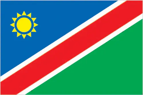
This case is not an exception either; a wide red stripe edged by narrow white stripes divides the flag diagonally from lower hoist corner to upper fly corner; the upper hoist-side triangle is blue and charged with a yellow, 12-rayed sunburst; the lower fly-side triangle is green; red signifies the heroism of the people and their determination to build a future of equal opportunity for all; white stands for peace, unity, tranquility, and harmony; blue represents the Namibian sky and the Atlantic Ocean, the country’s precious water resources and rain; the yellow sun denotes power and existence; green symbolizes vegetation and agricultural resources.
Apart from the flag, the symbol of national unity is the national anthem. The anthem’s primary purpose is to share the nation’s core values, endeavors, and patriotic feelings.
Namibia’s national symbols: oryx (antelope); national colors: blue, red, green, white, yellow.
Constitution of Namibia
The existence of the nation is based on the constitution. Some constitutions knew worldwide, like the U.S. Constitution that was accepted on the 17th of September 1787, in Philadelphia, the United States of America’s Constitution.
It is not related to the declaration of independence that was stolen by Nicolas Cage in the movie National Treasure 🙂
What is the legal system of Namibia?
Most of the time, the legal system of a country is the focus of lawyers. It is a common fact that there are two main approaches in the world, “the law in books” and “the law in action.”
In the Anglo-Saxon world, the practice is the “law in action,” while in the rest of the world, the law is based on Roman law, the “law in books.”
Namibia’s legal system is a mixed legal system of uncodified civil law based on Roman-Dutch law and customary law.
It was Aristotle who founded the Theory of 3 separations of powers. In his view, these are the council of public affairs, the magistrates, and the justice system. The age of enlightenment was the time when terminologies have defined the way we still use them. In most democratic countries, the three authorities separated from each other. In dictatorships, the rules usually interweaved in one hand.
About the legislative branch of Namibia, we can highlight the following structures bicameral Parliament consists of the National Assembly (104 seats; 96 members directly elected in multi-seat constituencies by proportional representation vote to serve 5-year terms and eight nonvoting members appointed by the president) and the National Council, which primarily reviews legislation passed and referred by the National Assembly (26 seats (to be expanded to 42 in 2016); members indirectly elected two each by the 13 regional councils to serve 5-year terms).
About the unemployment rate, labor force, and poverty line in Namibia
One of the major problems of the 21st-century economy is unemployment. Governments are struggling to maintain a low level of the unemployment rate. Still, as a result of automation, the cheap 3rd world labor, and the outsourcing of workflow, these attempts fail. In Namibia, the labor force is 1.21 million (2016 estimate). Please bear in mind that the population in Namibia is total: 36.4 deaths / 1,000 live births; male: 38.7 deaths / 1,000 live births, female: 34.1 deaths / 1,000 live births (2016 estimate) – as we already mentioned above.
The rate of unemployment in Namibia is 28.1% (2014 estimate).
Widely known that the gap between the rich and poor is widening on an enormous scale.
According to the 2017 shocking Oxfam report, the most affluent eight people’s fortune is equal to the wealth of the poorest half of the world’s population.
In Namibia, the households’ income and consumption compared to the entire population: lowest 10%: 2.4% highest 10%: 42% (2010).
Another widely used indicator is the so-called GINI index, which measures the inequalities of statistical dispersion, but is mainly used for measuring the sharing of income and fortune.
The GINI index was named after its founder Corrado Gini, an Italian economist. Gini index has grades between 0-1, but often it is used on a percentage basis. It is 0 if the examined criteria territorial distribution is equal. It is one of the criteria concentrated on the territory. In Namibia, the GINI index is .59,7 (2010).
The states usually set up a poverty line, which is more or less, is a subjective measure. It varies by country; its base is often the minimum pension, the incomes of the most deficient 20 percent, the X percent of income per capita Etc.
In Namibia, the poverty line people are the lowest 10%: 2.4% highest 10%: 42% (2010).
About the budget and central governments debt of Namibia
The available budget mainly defines the state’s economy. Namibia’s budget is; revenues: $3.818 billion, expenditures: $4.408 billion (2016 estimate). Taxes and other revenues are 37.5% of GDP (2016 estimate).
The budget deficit (Budget surplus (+) or deficit (-)) is N/A.
The fiscal year in Namibia is 1 April – 31 March.
In the country’s economy, we have to consider the public debt. Public debt is the consolidated sum of the state’s local, federal, and central government debt.
Inflation rate and prime lending rate in Namibia
A few further interesting and relevant economic data are the following; Inflation rate: 6.8% (2016 estimate), 3.4% (2015 estimate), and the rate of the Commercial bank prime lending rate: 9.8% (31 December 2016 estimate).
Export/import partners and data of Namibia
Namibia, with the export of products, industrial tools, and other services, generates revenue. Namibia’s export value is $4.185 billion (2016 estimate), $4.015 billion (2015 estimate). The total revenue of these activities: diamonds, copper, gold, zinc, lead, uranium; cattle, white fish, and mollusks.
The most important export partners of Namibia are N/A.
The most important imported products are foodstuffs, petroleum products, fuel, machinery and equipment, chemicals, and the countries from where the import is coming: N/A.
Renewable energies used in Namibia
To suppress the pollution of the environment, renewable energies have to replace the fossil energy. The more the proportion of renewable energies in a country means more effort against pollution. Namibia, the indicator of how much of the country’s produced energy is coming from the hydroelectric source, is 68.2% of total installed capacity (2013 estimate).
To indicate how much another renewable energy produced is 0% of total installed capacity (2013 estimate).
Telecommunication data of Namibia, calling code
To maintain the economy, the development of a reliable and modern telecommunications infrastructure is crucial. We can say the following about Namibia; good system; core fiber-optic network links most centers with digital connections. Domestic: multiple mobile-cellular providers with a combined subscribership of about 110 telephones per 100 persons. International: country code – 264; fiber-optic cable to South Africa, microwave radio relay link to Botswana, direct links to other neighboring countries; connected to the South African Far East submarine cable through South Africa; connected to the West Africa Cable Sy (2015).
Transport infrastructure in Namibia
In the 21st century, we often say that the world has become small and there are no distances anymore. With widespread air travel when (sometimes) there are no visa restrictions, it is easy to reach other countries, but if the distance is not too long, we can also use railway or water transportation.
The number of airports in Namibia: 112 (2013), and the number of heliports: N/A.
The total length of the roadways in Namibia: total: 44,138 km, paved: 6,387 km, unpaved: 37,751 km (2010).
The total length of the waterways in Namibia: N/A.
Are you traveling to Namibia?
If you plan to travel by plane to Namibia, try our air ticket comparison site, where you can choose from hundreds of carriers and offers. Our application is scanning the market and shows you the best and the cheapest deals without any extra charge or commission.
Are you looking for a hotel, apartment another kind of accommodation in Namibia, Africa? We are here to help you to find your accommodation from budget to luxury. Our search engine is scanning, regularly updating data from hundreds of accommodation websites and more than a million offers. You can quickly and easily find your hotel stay anywhere in the world, without any extra charge or commission.
Facts & data about Namibia
Name of the country: conventional long way: the Republic of Namibia, traditional short form: Namibia, local long form: the Republic of Namibia, local short state: Namibia, former: German South-West Africa (Deutsch Suedwest Afrika), South-West Africa, etymology: named for the coastal Namib Desert; the name “namib” means “vast place” in the Nama/Damara language.
| Abbreviation: Namibia | Geographic coordinates: 22 00 S, 17 00 E |
Country Location: Africa |
| Capital of Namibia: Windhoek | GPS of the Capital: 22 34 S 17 05 E |
Position: Southern Africa, bordering the South Atlantic Ocean, between Angola and South Africa |
| Land area: total: 824,292 sq km; land: 823,290 sq km, water: 1,002 sq km | Terrain: mostly high plateau; Namib Desert along coast; Kalahari Desert in east |
Area comparative: slightly more than half the size of Alaska |
| Population: 2,436,469 (July 2016 estimate) | Population grow rate: 1.98% (2016 estimate) | Sex ratio: at birth: 1.03 male(s) / female, 0-14 years: 1.02 male(s) / female, 15-24 years: 0.99 male(s) / female, 25-54 years: 0.91 male(s) / female, 55-64 years: 0.82 male(s) / female, 65 years and over: 0.75 male(s) / female, total population: 0.96 male(s) / female (2016 estimate) |
| Exports: $4.185 billion (2016 estimate), $4.015 billion (2015 estimate) | Imports: $6.888 billion (2016 estimate), $6.914 billion (2015 estimate) | Import partners: N/A |
| Urbanization: urban population: 46.7% of the total population (2015) | Major urban area(s): WINDHOEK (capital) 368,000 (2015) | Median age: total: 21 years; male: 20.2 years, female: 21.7 years (2016 estimate) |
| Internet users: total: 493,000. Percent of the population: 22.3% (July 2015 estimate) | Telephones (fixed-lines): total subscriptions: 182,507. Subscriptions per 100 inhabitants: 8 (July 2015 estimate) | Telephones (mobile, cellular): total: 2.443 million. Subscriptions per 100 inhabitants: 110 (July 2012 estimate) |
| Unemployment rate: 28.1% (2014 estimate) | Nationality: Namibian(s) adjective: Namibian | National holidays: Independence Day, 21 March (1990) |
| Life expectancy at birth: total population: 63.6 years. Male: 62.1 years, female: 65.1 years (2016 estimate) | Total fertility rate: 3.36 children born / woman (2016 estimate) | Birthrate: 27.9 births / 1,000 population (2016 estimate) |
| Literacy: age 15 and over can read and write. Total population: 81.9%; male: 79.2%, female: 84.5% (2015 estimate) | Legal system: mixed legal system of uncodified civil law based on Roman-Dutch law and customary law | Suffrage: 18 years of age, universal |
| Industries: meatpacking, fish processing, dairy products, pasta, beverages; mining (diamonds, lead, zinc, tin, silver, tungsten, uranium, copper) | Industrial production growth rate: 4.6% (2016 estimate) | GDP real growth rate: 4.2% (2016 estimate) 5.3% (2015 estimate) 6.5% (2014 estimate) |
Do you like this Namibia Google maps™ & country information page?
Please do us a favor: Share or like this page using the icons at the top of the page. We also do encourage you to visit our Facebook page for more travel and country related information.
Many thanks for visiting and sharing this map & country information site!