
 |
 |
 |
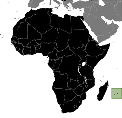
| Borderline map of Mauritius | Location map of Mauritius | Flag of Mauritius |
Google Maps and Detailed Facts of Mauritius (MU). This page lets you explore Mauritius and its border countries (Country Location: Southern Africa, an island in the Indian Ocean, about 800 km (500 mi) east of Madagascar) through detailed Satellite imagery – fast and easy as never before Google Maps.
Find comprehensive information about this country’s diversity below: Google maps, geography, economy, science, people, culture, environment, government, and history – All in One Wiki page.
There is also a Street View and free Driving Directions at your service. Your Google Satellite Map Sightseeing in Mauritius, in Africa, starts here at Driving Directions and Maps.com.
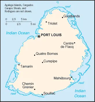
Mauritius Google Maps & Satellite Maps
The map below shows Mauritius with its cities, towns, highways, main roads, streets, and Street Views. To find a location, use the form below, type any city or place, view a simple map, and click the “show map” button.
The Google map above shows Mauritius with its location: Africa (geographic coordinates: 20 17 S, 57 33 E) and the international borders of Mauritius; 0 km; furthermore, it’s inland counties boundaries.
Hint: Look at the Street view in Mauritius, or Africa. All you have to do is drag and pull the little yellow man (named: Pegman) on the Google map above the desired location. After that, whenever it is available (more than 50 countries globally), blue stripes will appear to show the photos and details from Google’s regularly updated data image base. In case if you have signed in to your Google account currently, you may have a look at the satellite map of this country/area as well.
The map of Mauritius, Africa, is for informational use only. No representation is made or warrantied given any map or its content by Driving Directions and Maps site. The user assumes all risks of using this Mauritius Google map and facts/wiki.
About Mauritius in detail
Where is Mauritius?
Mauritius, in case, if you are looking on the map under the Coordinates 20 09 S 57 29 E otherwise in Africa, in Southern Africa, island in the Indian Ocean, about 800 km (500 mi) east of Madagascar.
What is the capital city of Mauritius?
The capital city of Mauritius is Port Louis.
What is the time in Port Louis?
It is 9 hours ahead of Washington, D.C. during Standard Time; Port Louis’s timezone is UTC+4.
What is the Internet code for Mauritius?
The Top Level Domain (TLD) for Mauritius is: .mu
What is the size of Mauritius?
Mauritius’s territory is total: 2,040 sq km; land: 2,030 sq km, water: 10 sq km.
If we want to describe Mauritius’s territory’s size is almost 11 times the size of Washington, DC.
If we would like to walk around and discover Mauritius, we can cover 0 km.
What is the water coverage of Mauritius?
We have already mentioned what percentage of Mauritius is covered by water (see below), and this includes 177 km coastline.
What is the climate like in Mauritius?
Mauritius’s climate is tropical, modified by southeast trade winds: warm, dry winter (May to November): hot, wet, humid summer (November to May).
Geographical data of Mauritius
Mauritius elevation; mean elevation: N/A, elevation extremes; lowest point: Indian Ocean 0 m, highest point: Mont Piton 828 m.
Mauritius’s specific geographical details include a small coastal plain rising to discontinuous mountains encircling the central plateau.
Suppose we would like to describe the countries location from a different perspective. In that case, it is safe to say, and easy to read from a map, Mauritius is the main island, from which the country derives its name, is of volcanic origin and is almost surrounded by coral reefs; former home of the dodo, a large flightless bird related to pigeons, driven to extinction by the end of the 17th century through a combination of hunting and the introduction of predatory species.
Resources and land use of Mauritius
The country’s main mined products are arable land, fish. The population partly uses the earlier highlighted land territory and partly left in its natural state: agricultural land: 43.8%; arable land 38.4%; permanent crops 2%; permanent pasture 3.4%; forest: 17.3%; other: 38.9% (2011 estimate).
Population data of Mauritius
The number of inhabitants of Mauritius is 1,348,242 (July 2016 estimate).
If we examine the proportion of the population distribution, it is safe to say that N/A.
If we look at the proportion of the urbanized and barely populated areas, these are the figures: urban population: 39.7% of the total population (2015).
Most of the population in Mauritius is concentrated in PORT LOUIS (capital) 135,000 (2014).
Ethnicity in Mauritius
According to ethnicity details, the ethnic groups are Indo-Mauritian 68%, Creole 27%, Sino-Mauritian 3%, Franco-Mauritian 2%.
Spoken languages in Mauritius
The spoken languages in Mauritius are the following: Creole 86.5%, Bhojpuri 5.3%, French 4.1%, two languages 1.4%, other 2.6% (includes English, the official language, which is spoken by less than 1% of the population), unspecified 0.1% (2011 estimate).
What are the most important religions in Mauritius?
During the general census, researchers examine the churches, according to this: Hindu 48.5%, Roman Catholic 26.3%, Muslim 17.3%, other Christian 6.4%, other 0.6%, none 0.7%, unspecified 0.1% (2011 estimate).
Further population data of Mauritius
The proportion of gender and age tells a lot about the society as follows 0-14 years: 20.44% (male 140,808 / female 134,826) 15-24 years: 15.06% (male 102,593 / female 100,465) 25-54 years: 43.87% (male 295,794 / female 295,719) 55-64 years: 11.37% (male 72,733 / female 80,621) 65 years and over: 9.25% (male 50,888 / female 73,795) (2016 estimate). It also a significant factor in a society the population growth rate, which in the case of Mauritius is 0.61% (2016 estimate).
The population growth rate is based on two elements, the birth, and the death rate. In Mauritius the birth rate is 13.1 births / 1,000 population (2016 estimate), the death rate 7 deaths / 1,000 population (2016 estimate).
In this day and age in developed societies, the first child borns later compared to the previous centuries and decades, so childbearing is extended. In Mauritius, the average age of mothers at the first childbirth is N/A.
Although the children’s birth is postponed in the best-case scenario, the parents can still see their kids grow as life expectancy also extended. In the case of Mauritius, these figures are. With the introduction of modern medicine, vaccinations, and the proper hygienic conditions, the infant mortality rate is in a steep decline. The infant mortality statistics in Mauritius are the following: N/A. Relevant data is the budget of healthcare, which is in the case of this country is 4.8% of GDP (2014).
Economic data of Mauritius
Suppose we would like to describe a country. We also have to mention its economy; Since independence in 1968, Mauritius has undergone a remarkable economic transformation from a low-income, agriculturally based economy to a diversified, upper middle-income economy with growing industrial, financial, and tourist sectors. Mauritius has aThe economy currently rests on sugar, tourism, textiles and apparel, and financial services, but is expanding into fish processing, information and communications technology, and hospitality and property development. Mauritius’ sound economic policies and prudent banking practices helped mitigate the global financial crisis’s negative effects in 2008-09. GDP grew in the 3-4% per year range in 2010-16, and the country continues to expand its trade and investment.
GDP is a prominent figure, as all the relevant calculations and statistics are based on it. GDP in Mauritius is $11.74 billion (2015 estimate).
Another important indicator is the rate of GDP growth, which in Mauritius is 3.5% (2016 estimate) 3.5% (2015 estimate) 3.6% (2014 estimate).
These statistics affect the world economy; remember, in 2015, the Chinese real GDP growth rate was worse than expected; The world markets fall, and the Chinese stock exchange was temporarily suspended.
A further major factor of a country’s economy, the GDP per capita. In Mauritius this is $20,500 (2016 estimate) $19,800 (2015 estimate) $19,200 (2014 estimate).
In the economy, the Trinity is in common places, such as agriculture, industry, and services.
What are the agricultural products Mauritius produces?
Mauritius’s main agricultural products are sugarcane, tea, corn, potatoes, bananas, pulses, cattle, goats, fish.
The essential segments are food processing (largely sugar milling), textiles, clothing, mining, chemicals, metal products, transport equipment, nonelectrical machinery, and tourism. The crucial and regularly mentioned GDP is based on food processing (largely sugar milling), textiles, clothing, mining, chemicals, metal products, transport equipment, nonelectrical machinery, tourism.
Drinking water source in Mauritius
It is essential to mention that – thanks to the development of the infrastructure -, the rate of potable water improved: urban: 99.9% of the population, rural: 99.8% of the population, total: 99.9% of the population. Unimproved: urban: 0.1% of the population, rural: 0.2% of the population, total: 0.1% of the population (2015 estimate).
The average number of childbirth in Mauritius
In Mauritius, the average delivery number is 1.75 children born / woman (2016 estimate).
Population, median age, migration, and citizenship in Mauritius
The population’s average age is 34.8 years; male: 33.9 years, female: 35.8 years (2016 estimate). The age of adulthood varies in every country of the world in Mauritius; it is 18 years of age, universal.
When we are experiencing an unprecedented scale of migration and globalization, it is an important factor in the number of new immigrants. In Mauritius is 0 migrant(s) / 1,000 population (2016 estimate). It is important to know how to apply for citizenship: citizenship by birth: yes. Citizenship by descent: yes. Dual citizenship recognized: yes, the residency requirement for naturalization: 5 out of the previous 7 years, including the last 12 months.
Is Mauritius a safe destination? Healthcare services and infectious diseases in Mauritius
Many of the travelers are looking into the healthcare services and infectious diseases of their destinations. In Mauritius, the hospital beds’ density is 3.4 beds / 1,000 population (2011).
According to the WHO rating regarding contagious diseases in Mauritius: N/A.
However, HIV is not curable but maintainable. Let’s do not forget when the disease surfaced; it was a world threatening condition. Unfortunately, in some countries, it is still very high the number of infected patients and fatalities due to the disease.
In Mauritius, the number of HIV/AIDS deaths: N/A.
Regarding tourism obesity, not an important issue, but we have to mention health statistics, as it is the plague of the 20th and the 21st century. The rate of obese adults in Mauritius is 18.8% (2014).
What are the natural hazards in Mauritius? Is there any?
Mauritius’s most known natural risk are cyclones (November to April), almost surrounded by reefs that may pose maritime hazards.
More interesting facts about Mauritius
A few words about the past, as every country and society, is connected to its history; Although known to Arab and Malay sailors as early as the 10th century, Mauritius was first explored by the Portuguese in the 16th century and subsequently settled by the Dutch – who named it in honor of Prince Maurits van NASSAU – in the 17th century. The French assumed control in 1715, developing the island into a substantial naval base overseeing Indian Ocean trade and establishing a plantation economy of sugar cane. The British captured the island in 1810, during the Napoleonic Wars. Mauritius remained a strategically important British naval base, and later an air station, playing an essential role during World War II for anti-submarine and convoy operations and the collection of signals intelligence. Independence from the UK was attained in 1968. A stable democracy with regular free elections and a positive human rights record has attracted considerable foreign investment and has one of Africa’s highest per capita incomes.
In every nation’s memory, some cornerstones placed the country on the timeline of history. The date of declaration of independence of Mauritius: 12 March 1968 (from the UK).
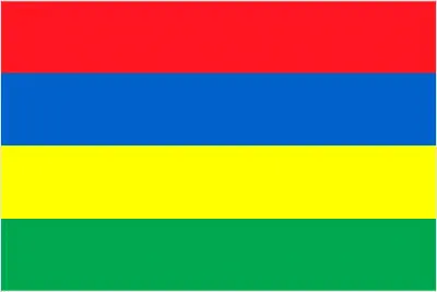
The flag and other symbols of Mauritius
The colors, symbols, and animals on the flag usually have a historical background or an important milestone or memory of the nation.
This case is not an exception either; four equal horizontal bands of red (top), blue, yellow, and green; red represents self-determination and independence, blue the Indian Ocean surrounding the island, yellow has been interpreted as the new light of freedom, golden sunshine, or the bright future. Green can symbolize either agriculture or the lush vegetation of the island.
Apart from the flag, the symbol of national unity is the national anthem. The anthem’s primary purpose is to share the nation’s core values, endeavors, and patriotic feelings.
Mauritius’s national symbols: dodo bird, Trochetia Boutoniana flower; national colors: red, blue, yellow, green.
Constitution of Mauritius
The existence of the nation is based on the constitution. Some constitutions knew worldwide, like the U.S. Constitution that was accepted on the 17th of September 1787, in Philadelphia, the United States of America’s Constitution.
It is not related to the declaration of independence that was stolen by Nicolas Cage in the movie National Treasure 🙂
What is the legal system of Mauritius?
Most of the time, the legal system of a country is the focus of lawyers. It is a common fact that there are two main approaches in the world, “the law in books” and “the law in action.”
In the Anglo-Saxon world, the practice is the “law in action,” while in the rest of the world, the law is based on Roman law, the “law in books.”
Mauritius’s legal system is a civil legal system based on French civil law with some English common law elements.
It was Aristotle who founded the Theory of 3 separations of powers. In his view, these are the council of public affairs, the magistrates, and the justice system. The age of enlightenment was the time when terminologies have defined the way we still use them. In most democratic countries, the three authorities separated from each other. In dictatorships, the rules usually interweaved in one hand.
About the legislative branch of Mauritius, we can highlight the following structures unicameral National Assembly or Assemblee Nationale (70 seats maximum; 62 members directly elected in single- and multi-seat constituencies by simple majority vote and up to 8 seats allocated to non-elected party candidates by the Electoral Commissioner’s Office to ensure fair and adequate representation of each community and party in the Assembly, as outlined in the Constitution; members serve 5-year terms).
About the unemployment rate, labor force, and poverty line in Mauritius
One of the major problems of the 21st-century economy is unemployment. Governments are struggling to maintain a low level of the unemployment rate. Still, as a result of automation, the cheap 3rd world labor, and the outsourcing of workflow, these attempts fail. In Mauritius, the labor force is 624,700 (2016 estimate). Please bear in mind that the population in Mauritius is total: 10 deaths / 1,000 live births; male: 11.9 deaths / 1,000 live births, female: 8.1 deaths / 1,000 live births (2016 estimate) – as we already mentioned above.
The rate of unemployment in Mauritius is 7.8% (2016 estimate).
Widely known that the gap between the rich and poor is widening on an enormous scale.
According to the 2017 shocking Oxfam report, the most affluent eight people’s fortune is equal to the wealth of the poorest half of the world’s population.
In Mauritius, the households’ income and consumption compared to the entire population: lowest 10%: N/A% highest 10%: N/A%.
Another widely used indicator is the so-called GINI index, which measures the inequalities of statistical dispersion, but is mainly used for measuring the sharing of income and fortune.
The GINI index was named after its founder Corrado Gini, an Italian economist. Gini index has grades between 0-1, but often it is used on a percentage basis. It is 0 if the examined criteria territorial distribution is equal. It is one of the criteria concentrated on the territory. In Mauritius, the GINI index is .35,9 (2012 estimate).
The states usually set up a poverty line, which is more or less, is a subjective measure. It varies by country; its base is often the minimum pension, the incomes of the most deficient 20 percent, the X percent of income per capita Etc.
In Mauritius, the poverty line people are the lowest 10%: N/A% highest 10%: N/A%.
About the budget and central governments debt of Mauritius
The available budget mainly defines the state’s economy. Mauritius’s budget is; revenues: $2.478 billion, expenditures: $2.95 billion (2016 estimate). Taxes and other revenues are 21.1% of GDP (2016 estimate).
The budget deficit (Budget surplus (+) or deficit (-)) is N/A.
The fiscal year in Mauritius is 1 July – 30 June.
In the country’s economy, we have to consider the public debt. Public debt is the consolidated sum of the state’s local, federal, and central government debt.
Inflation rate and prime lending rate in Mauritius
A few further interesting and relevant economic data are the following; Inflation rate: 1.1% (2016 estimate), 1.3% (2015 estimate), and the rate of the Commercial bank prime lending rate: 8.3% (31 December 2016 estimate).
Export/import partners and data of Mauritius
Mauritius, with the export of products, industrial tools, and other services, generates revenue. The export value in Mauritius is: $2.676 billion (2016 estimate), $2.685 billion (2015 estimate). These activities’ total revenue: clothing and textiles, sugar, cut flowers, molasses, fish, primates (for research).
The most important export partners of Mauritius are the UK 13.2%, UAE 12.4%, France 11.9%, US 10.7%, South Africa 8.6%, Madagascar 6.5%, Italy 5.4%, Spain 4.4% (2015).
The most important imported products are manufactured goods, capital equipment, foodstuffs, petroleum products, chemicals, and the countries from where the import is coming: India 18.7%, China 17.8%, France 7.1%, South Africa 6.5%, Vietnam 4.4% (2015).
Renewable energies used in Mauritius
To suppress the pollution of the environment, renewable energies have to replace the fossil energy. The more the proportion of renewable energies in a country means more effort against pollution. Mauritius, the indicator of how much of the country’s produced energy is coming from the hydroelectric source, is 3.3% of total installed capacity (2013 estimate).
To indicate how much another renewable energy produced is 0.2% of total installed capacity (2013 estimate).
Telecommunication data of Mauritius, calling code
To maintain the economy, the development of a reliable and modern telecommunications infrastructure is crucial. We can say the following about Mauritius; a small system with good service. Domestic: the monopoly over fixed-line services terminated in 2005; fixed-line teledensity roughly 25 per 100 persons; mobile-cellular services launched in 1989 with current teledensity approximately 130 per 100 persons. International: country code – 230; landing point for the SAFE submarine cable that provides links to Asia and South Africa where it connects to the SAT-3/WASC submarine cable that provides further links to parts of East Africa and Europe; satellite earth station – 1 In (2015).
Transport infrastructure in Mauritius
In the 21st century, we often say that the world has become small and there are no distances anymore. With widespread air travel when (sometimes) there are no visa restrictions, it is easy to reach other countries, but if the distance is not too long, we can also use railway or water transportation.
The number of airports in Mauritius: 5 (2013), and the number of heliports: N/A.
The total length of the roadways in Mauritius: total: 2,149 km, paved: 2,149 km (includes 75 km of expressways) (2012).
The total length of the waterways in Mauritius: N/A.
Are you traveling to Mauritius?
If you plan to travel by plane to Mauritius, try our air ticket comparison site, where you can choose from hundreds of carriers and offers. Our application is scanning the market and shows you the best and the cheapest deals without any extra charge or commission.
Are you looking for a hotel, apartment another kind of accommodation in Mauritius, Africa? We are here to help you to find your accommodation from budget to luxury. Our search engine is scanning, regularly updating data from hundreds of accommodation websites and more than a million offers. You can quickly and easily find your hotel stay anywhere in the world, without any extra charge or commission.
Facts & data about Mauritius
Name of the country: conventional long way: the Republic of Mauritius, traditional short form: Mauritius, local long form: the Republic of Mauritius, local short state: Mauritius. Note: island named after Prince Maurice VAN NASSAU, stadtholder of the Dutch Republic, in 1598.
| Abbreviation: Mauritius | Geographic coordinates: 20 17 S, 57 33 E |
Country Location: Africa |
| Capital of Mauritius: Port Louis | GPS of the Capital: 20 09 S 57 29 E |
Position: Southern Africa, island in the Indian Ocean, about 800 km (500 mi) east of Madagascar |
| Land area: total: 2,040 sq km; land: 2,030 sq km, water: 10 sq km | Terrain: small coastal plain rising to discontinuous mountains encircling central plateau |
Area comparative: almost 11 times the size of Washington, DC |
| Population: 1,348,242 (July 2016 estimate) | Population grow rate: 0.61% (2016 estimate) | Sex ratio: at birth: 1.05 male(s) / female, 0-14 years: 1.04 male(s) / female, 15-24 years: 1.02 male(s) / female, 25-54 years: 1 male(s) / female, 55-64 years: 0.9 male(s) / female, 65 years and over: 0.68 male(s) / female, total population: 0.97 male(s) / female (2016 estimate) |
| Exports: $2.676 billion (2016 estimate), $2.685 billion (2015 estimate) | Imports: $4.355 billion (2016 estimate), $4.526 billion (2015 estimate) | Import partners: India 18.7%, China 17.8%, France 7.1%, South Africa 6.5%, Vietnam 4.4% (2015) |
| Urbanization: urban population: 39.7% of the total population (2015) | Major urban area(s): PORT LOUIS (capital) 135,000 (2014) | Median age: total: 34.8 years; male: 33.9 years, female: 35.8 years (2016 estimate) |
| Internet users: total: 672,000. Percent of the population: 50.1% (July 2015 estimate) | Telephones (fixed-lines): total subscriptions: 380,000. Subscriptions per 100 inhabitants: 28 (July 2015 estimate) | Telephones (mobile, cellular): total: 1.762 million. Subscriptions per 100 inhabitants: 132 (July 2015 estimate) |
| Unemployment rate: 7.8% (2016 estimate) | Nationality: Mauritian(s) adjective: Mauritian | National holidays: Independence Day, 12 March (1968) |
| Life expectancy at birth: total population: 75.6 years. Male: 72.2 years, female: 79.2 years (2016 estimate) | Total fertility rate: 1.75 children born / woman (2016 estimate) | Birthrate: 13.1 births / 1,000 population (2016 estimate) |
| Literacy: age 15 and over can read and write. Total population: 90.6%; male: 92.9%, female: 88.5% (2015 estimate) | Legal system: civil legal system based on French civil law with some elements of English common law | Suffrage: 18 years of age, universal |
| Industries: food processing (largely sugar milling), textiles, clothing, mining, chemicals, metal products, transport equipment, nonelectrical machinery, tourism | Industrial production growth rate: 2.8% (2016 estimate) | GDP real growth rate: 3.5% (2016 estimate) 3.5% (2015 estimate) 3.6% (2014 estimate) |
Do you like this Mauritius Google maps™ & country information page?
Please do us a favor: Share or like this page using the icons at the top of the page. We also do encourage you to visit our Facebook page for more travel and country related information.
Many thanks for visiting and sharing this map & country information site!