
 |
 |
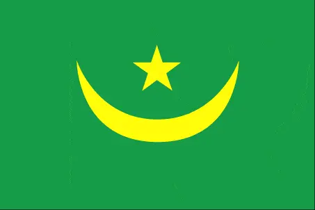 |
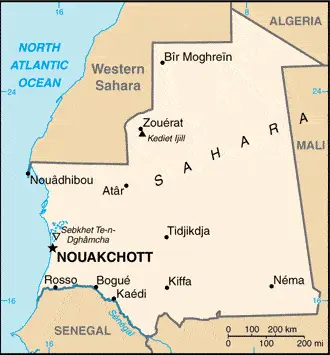
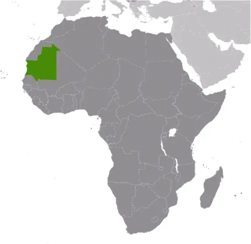
| Borderline map of Mauritania | Location map of Mauritania | Flag of Mauritania |
Google Maps and Detailed Facts of Mauritania (MR). This page lets you explore Mauritania and its border countries (Country Location: Western Africa, bordering the North Atlantic Ocean, between Senegal and Western Sahara) through detailed Satellite imagery – fast and easy as never before Google Maps.
Find comprehensive information about this country’s diversity below: Google maps, geography, economy, science, people, culture, environment, government, and history – All in One Wiki page.
There is also a Street View and free Driving Directions at your service. Your Google Satellite Map Sightseeing in Mauritania, in Africa, starts here at Driving Directions and Maps.com.
Mauritania Google Maps & Satellite Maps
The map below shows Mauritania with its cities, towns, highways, main roads, streets, and Street Views. To find a location, use the form below, type any city or place, view a simple map, and click the “show map” button.
The Google map above shows Mauritania with its location: Africa (geographic coordinates: 20 00 N, 12 00 W) and the international borders of Mauritania; total: 5,002 km. Border countries (total: 4): Algeria 460 km, Mali 2,236 km, Senegal 742 km, Western Sahara 1,564 km; furthermore, it’s inland counties boundaries.
Hint: Look at the Street view in Mauritania, or Africa. All you have to do is drag and pull the little yellow man (named: Pegman) on the Google map above the desired location. After that, whenever it is available (more than 50 countries globally), blue stripes will appear to show the photos and details from Google’s regularly updated data image base. In case if you have signed in to your Google account currently, you may have a look at the satellite map of this country/area as well.
The map of Mauritania, Africa, is for informational use only. No representation is made or warrantied given any map or its content by Driving Directions and Maps site. The user assumes all risks of using this Mauritania Google map and facts/wiki.
About Mauritania in detail
Where is Mauritania?
In case Mauritania is looking on the map under the Coordinates 18 04 N 15 58 W otherwise in Africa, in Western Africa, bordering the North Atlantic Ocean, between Senegal and Western Sahara.
What is the capital city of Mauritania?
The capital city of Mauritania is Nouakchott.
What is the time in Nouakchott?
It is 5 hours ahead of Washington, D.C. during Standard Time; the timezone of Nouakchott is UTC 0.
What is the Internet code for Mauritania?
The Top Level Domain (TLD) for Mauritania is: .mr
What is the size of Mauritania?
The territory of Mauritania is total: 1,030,700 sq km; land: 1,030,700 sq km, water: 0 sq km.
If we want to describe Mauritania’s territory’s size is slightly larger than three times the size of New Mexico.
If we would like to walk around and discover Mauritania, we can cover a total distance: 5,002 km.
What is the water coverage of Mauritania?
We have already mentioned the percentage of Mauritania covered by water (see below), including a 754 km coastline.
What is the climate like in Mauritania?
The climate of Mauritania is desert: always hot, dry, dusty.
Geographical data of Mauritania
Mauritania’s elevation; mean elevation: 276 m, elevation extremes; lowest point: Sebkhet Te-n-Dghamcha -5 m, highest point: Kediet Ijill 915 m.
Mauritania’s specific geographical details include mostly barren, flat plains of the Sahara; some central hills.
Suppose we would like to describe the countries location from a different perspective. In that case, it is safe to say, and easy to read from a map, Mauritania is considered both a part of North Africa’s Maghreb region and West Africa’s Sahel region; most of the population is concentrated in the cities of Nouakchott and Nouadhibou and along the Senegal River in the southern part of the country.
Resources and land use of Mauritania
The country’s main mined products are iron ore, gypsum, copper, phosphate, diamonds, gold, oil, fish. The population partly uses the earlier highlighted land territory and partly left in its natural state: agricultural land: 38.5%; arable land 0.4%; permanent crops 0%; permanent pasture 38.1%; forest: 0.2%; other: 61.3% (2011 estimate).
Population data of Mauritania
The number of inhabitants of Mauritania is 3,677,293 (July 2016 estimate).
Let’s examine the proportion of the population distribution. It is safe to say that with most of the country being a desert, vast areas of the country, particularly in the central, northern, and eastern regions, are without sizeable population clusters; half the population lives in or around the coastal capital of Nouakchott; smaller groups are found near the southern border with Mali and Senegal.
If we look at the proportion of the urbanized and barely populated areas, these are the figures: urban population: 59.9% of the total population (2015).
Most of the population in Mauritania is concentrated in NOUAKCHOTT (capital) 968,000 (2015).
Ethnicity in Mauritania
According to ethnicity details, the ethnic groups are black Moors (Haratines – Arab-speaking slaves, former slaves, and their descendants of African origin, enslaved by white Moors) 40%, white Moors (of Arab-Berber descent, known as Bidhan) 30%, black Africans (non-Arabic speaking, Halpulaar, Soninke, Wolof, and Bamara ethnic groups) 30%.
Spoken languages in Mauritania
The spoken languages in Mauritania are the following: Arabic (official language and national), Pulaar, Soninke, Wolof (all national languages), French. Note: spoken Arabic in Mauritania differs considerably from the modern standard Arabic used for official language is written purposes or in the media; the Mauritanian dialect, which incorporates many Berber words, is referred to as Hassaniya.
What are the most important religions in Mauritania?
According to this: Muslim (official), 100% during the general census, researchers examine the churches.
Further population data of Mauritania
The proportion of gender and age tells a lot about the society as follows 0-14 years: 38.87% (male 717,790 / female 711,694) 15-24 years: 19.86% (male 357,460 / female 372,744) 25-54 years: 32.96% (male 561,341 / female 650,580) 55-64 years: 4.61% (male 76,372 / female 93,065) 65 years and over: 3.71% (male 57,814 / female 78,433) (2016 estimate). It also a significant factor in a society the population growth rate, which in the case of Mauritania is 2.2% (2016 estimate).
The population growth rate is based on two elements, the birth, and the death rate. In Mauritania the birth rate is 30.9 births / 1,000 population (2016 estimate), the death rate 8.1 deaths / 1,000 population (2016 estimate).
In this day and age in developed societies, the first child borns later compared to the previous centuries and decades, so childbearing is extended. In Mauritania, the average age of mothers at the first childbirth is N/A.
Although the children’s birth is postponed in the best-case scenario, the parents can still see their kids grow as life expectancy also extended. In the case of Mauritania, these figures are. With the introduction of modern medicine, vaccinations, and the proper hygienic conditions, the infant mortality rate is in a steep decline. The infant mortality statistics in Mauritania are the following: N/A. Relevant data is the budget of healthcare, which is in the case of this country is 3.8% of GDP (2014).
Economic data of Mauritania
Suppose we would like to describe a country, we also have to mention its economy; natural resources and agriculture dominate Mauritania’s economy. Half the population still depends on agriculture and livestock for a livelihood, even though many nomads and subsistence farmers were forced into the cities by recurrent droughts. Mauritania’s extensive mineral resources include iron ore, gold, copper, gypsum, phosphate rock, uranium, crude oil, and natural gas exploration. Extractive commodities make up about three-quarters of Mauritania’s total exports. Risks to Mauritania’s economy include its recurring droughts, dependence on foreign aid and investment, and insecurity in neighboring Mali, as well as significant shortages of infrastructure, institutional capacity, and human capital.
GDP is a prominent figure, as all the relevant calculations and statistics are based on it. GDP in Mauritania is $4.718 billion (2015 estimate).
Another important indicator is the rate of GDP growth, which in Mauritania is 3.2% (2016 estimate), 1.2% (2015 estimate) 5.4% (2014 estimate).
These statistics affect the world economy; remember, in 2015, the Chinese real GDP growth rate was worse than expected; The world markets fall, and the Chinese stock exchange was temporarily suspended.
A further major factor of a country’s economy, the GDP per capita. In Mauritania this is $4,400 (2016 estimate) $4,400 (2015 estimate) $4,400 (2014 estimate).
In the economy, the Trinity is in common places, such as agriculture, industry, and services.
What are the agricultural products Mauritania produces?
Mauritania’s main agricultural products are dates, millet, sorghum, rice, corn, cattle, sheep.
The essential segments are fish processing, oil production, and mining (iron ore, gold, copper). Note: gypsum deposits have never been exploited. The crucial and regularly mentioned GDP is based on fish processing, oil production, mining (iron ore, gold, copper). Note: gypsum deposits have never been exploited.
Drinking water source in Mauritania
It is essential to mention that – thanks to the development of the infrastructure -, the rate of potable water improved: urban: 58.4% of the population, rural: 57.1% of the population, total: 57.9% of the population. Unimproved: urban: 41.6% of the people, rural: 42.9% of the people, total: 42.1% of the population (2015 estimate).
The average number of childbirth in Mauritania
In Mauritania, the average delivery number is 3.93 children born / woman (2016 estimate).
Population, median age, migration, and citizenship in Mauritania
The population’s average age is 20.3 years; male: 19.3 years, female: 21.2 years (2016 estimate). The age of adulthood varies in every country of the world in Mauritania; it is 18 years of age, universal.
When we are experiencing an unprecedented scale of migration and globalization, it is an important factor in the number of new immigrants. In Mauritania is -0.8 migrant(s) / 1,000 population (2016 estimate). It is important to know how to apply for citizenship: citizenship by birth: no. Citizenship by descent only: at least one parent must be a citizen of Mauritania. Dual citizenship recognized: no—residency requirement for naturalization: 5 years.
Is Mauritania a safe destination? Healthcare services and infectious diseases in Mauritania
Many of the travelers are looking into the healthcare services and infectious diseases of their destinations. In Mauritania, the hospital beds’ density is 0.4 beds / 1,000 population (2006).
According to the WHO rating regarding contagious diseases in Mauritania, the degree of risk: very high food or waterborne diseases: bacterial and protozoal diarrhea, hepatitis A, and typhoid fever vectorborne diseases: malaria and dengue fever respiratory disease: meningococcal meningitis animal contact disease: rabies (2016).
However, HIV is not curable but maintainable. Let’s do not forget when the disease surfaced; it was a world threatening condition. Unfortunately, in some countries, it is still very high the number of infected patients and fatalities due to the disease.
In Mauritania, the number of HIV/AIDS deaths: N/A.
Regarding tourism obesity, not an important issue, but we have to mention health statistics, as it is the plague of the 20th and the 21st century. The rate of obese adults in Mauritania is 8.6% (2014).
What are the natural hazards in Mauritania? Is there any?
Mauritania’s most known natural risk is hot, dry, dust/sand-laden sirocco wind primarily in March and April; periodic droughts.
More interesting facts about Mauritania
A few words about the past, as every country and society, is connected to its history; Independent from France in 1960, Mauritania annexed the southern third of the former Spanish Sahara (now Western Sahara) in 1976 but relinquished it after three years of raids by the Polisario guerrilla front seeking independence for the territory. Maaouya Ould Sid Ahmed TAYA seized power in a coup in 1984 and ruled Mauritania with a heavy hand for more than two decades. A series of presidential elections that he held were widely seen as flawed.
A bloodless coup in August 2005 deposed President TAYA and ushered in a military council that oversaw a transition to democratic rule. Independent candidate Sidi Ould Cheikh ABDALLAHI was inaugurated in April 2007 as Mauritania’s first freely and legally elected president. His term ended prematurely in August 2008 when a military junta led by General Mohamed Ould Abdel AZIZ deposed him and installed a military council government. AZIZ was subsequently elected president in July 2009 and sworn in the following month. AZIZ sustained injuries from an accidental shooting by his own troops in October 2012 but has maintained his authority. He was re-elected in 2014 to a second and final term as president (according to the present constitution).
The country continues to experience ethnic tensions among three major groups: Arabic-speaking descendants of slaves (Haratines), Arabic-speaking “White Moors” (Bidhan), and members of Sub-Saharan ethnic groups mostly originating in the Senegal River valley (Halpulaar, Soninke, and Wolof). Mauritania confronts a terrorism threat by al-Qa’ida in the Islamic Maghreb, which launched successful attacks between 2005 and 2010.
In every nation’s memory, some cornerstones placed the country on the timeline of history. The date of declaration of independence of Mauritania: 28 November 1960 (from France).
The flag and other symbols of Mauritania
The colors, symbols, and animals on the flag usually have a historical background or an important milestone or memory of the nation.
This case is not an exception either; green with a yellow five-pointed star above a yellow, horizontal crescent; the closed side of the crescent is down; the crescent, star, and color green are traditional symbols of Islam; green also represents hope for a bright future; the yellow color stands for the sands of the Sahara.
Apart from the flag, the symbol of national unity is the national anthem. The anthem’s primary purpose is to share the nation’s core values, endeavors, and patriotic feelings.
National symbols of Mauritania: star and crescent; national colors: green, yellow.
Constitution of Mauritania
The existence of the nation is based on the constitution. Some constitutions knew worldwide, like the U.S. Constitution that was accepted on the 17th of September 1787, in Philadelphia, the United States of America’s Constitution.
It is not related to the declaration of independence that was stolen by Nicolas Cage in the movie National Treasure 🙂
What is the legal system of Mauritania?
Most of the time, the legal system of a country is the focus of lawyers. It is a common fact that there are two main approaches in the world, “the law in books” and “the law in action.”
In the Anglo-Saxon world, the practice is the “law in action,” while in the rest of the world, the law is based on Roman law, the “law in books.”
The legal system of Mauritania is a mixed legal system of Islamic and French civil law.
It was Aristotle who founded the Theory of 3 separations of powers. In his view, these are the council of public affairs, the magistrates, and the justice system. The age of enlightenment was the time when terminologies have defined the way we still use them. In most democratic countries, the three authorities separated from each other. In dictatorships, the rules usually interweaved in one hand.
About the legislative branch of Mauritania, we can highlight the following structures bicameral Parliament or Barlamane consists of the Senate or Majlis al-Shuyukh (56 seats; 53 members indirectly elected by municipal leaders by simple majority vote and three directly elected by Mauritanians abroad; members serve a 6-year term with one-third of membership renewed every two years) and the National Assembly or Al Jamiya Al Wataniya (146 seats; 106 members directly elected in single- and two-seat constituencies by absolute majority vote in two rounds if needed and 40 directly elected in constituencies with three or more seats by proportional representation vote; members serve a 5-year term).
About the unemployment rate, labor force, and poverty line in Mauritania
One of the major problems of the 21st-century economy is unemployment. Governments are struggling to maintain a low level of the unemployment rate. Still, as a result of automation, the cheap 3rd world labor, and the outsourcing of workflow, these attempts fail. In Mauritania, the labor force is 1.356 million (2016 estimate). Please bear in mind that the population in Mauritania is total: 53.3 deaths / 1,000 live births; male: 58.1 deaths / 1,000 live births, female: 48.2 deaths / 1,000 live births (2016 estimate) – as we already mentioned above.
The rate of unemployment in Mauritania is 31% (2013 estimate).
Widely known that the gap between the rich and poor is widening on an enormous scale.
According to the 2017 shocking Oxfam report, the most affluent eight people’s fortune is equal to the wealth of the poorest half of the world’s population.
In Mauritania, the households’ income and consumption compared to the entire population: lowest 10%: 2.5% highest 10%: 29.5% (2000).
Another widely used indicator is the so-called GINI index, which measures the inequalities of statistical dispersion, but is mainly used for measuring the sharing of income and fortune.
The GINI index was named after its founder Corrado Gini, an Italian economist. Gini index has grades between 0-1, but often it is used on a percentage basis. It is 0 if the examined criteria territorial distribution is equal. It is one of the criteria concentrated on the territory. In Mauritania, the GINI index is .39 (2000).
The states usually set up a poverty line, which is more or less, is a subjective measure. It varies by country; its base is often the minimum pension, the incomes of the most deficient 20 percent, the X percent of income per capita Etc.
In Mauritania, the poverty line people are the lowest 10%: 2.5% highest 10%: 29.5% (2000).
About the budget and central governments debt of Mauritania
The available budget mainly defines the state’s economy. The budget of Mauritania is; revenues: $1.143 billion, expenditures: $1.43 billion (2016 estimate). Taxes and other revenues are 24.2% of GDP (2016 estimate).
The budget deficit (Budget surplus (+) or deficit (-)) is N/A.
The fiscal year in Mauritania is the calendar year.
In the country’s economy, we have to consider the public debt. Public debt is the consolidated sum of the state’s local, federal, and central government debt.
Inflation rate and prime lending rate in Mauritania
A few further interesting and relevant economic data are the following; Inflation rate: 3.5% (2016 estimate), 0.5% (2015 estimate), and the rate of the Commercial bank prime lending rate: 17% (31 December 2016 estimate).
Export/import partners and data of Mauritania
Mauritania, with the export of products, industrial tools, and other services, generates revenue. The export value in Mauritania is: $1.212 billion (2016 estimate), $1.385 billion (2015 estimate). The total revenue of these activities: iron ore, fish and fish products, gold, copper, petroleum.
The most important export partners of Mauritania are China 32.7%, Switzerland 11.1%, Spain 8.6%, Italy 6.7%, Cote d’Ivoire 6.6%, Japan 5.7% (2015).
The most important imported products are machinery and equipment, petroleum products, capital goods, foodstuffs, consumer goods, and the countries from where the import is coming: China 25.5%, Algeria 8.4%, France 6.3%, Morocco 5.1%, Spain 4.8%, Brazil 4.5%, the United States 4% (2015).
Renewable energies used in Mauritania
To suppress the pollution of the environment, renewable energies have to replace the fossil energy. The more the proportion of renewable energies in a country means more effort against pollution. Mauritania, the indicator of how much of the country’s produced energy is coming from the hydroelectric source, is 33.1% of total installed capacity (2012 estimate).
To indicate how much another renewable energy produced is 0% of total installed capacity (2012 estimate).
Telecommunication data of Mauritania, calling code
To maintain the economy, the development of a reliable and modern telecommunications infrastructure is crucial. We can say Mauritania’s following: limited cable and open-wire lines, minor microwave radio relay links, and radiotelephone communications stations; mobile-cellular services are expanding rapidly. Domestic: fixed-line teledensity 1 per 100 persons; mobile-cellular network coverage extends mainly to urban areas with a roughly 100 per 100 persons; mostly cable and open-wire lines; a domestic satellite telecommunications system links Nouakchott. International: country code – 222; satellite earth stations – 3 (1 Intelsat – the Atlantic Ocean, 2 Arabsat); fiber-optic and asymmetric digital subscriber line cables for Internet access (2015).
Transport infrastructure in Mauritania
In the 21st century, we often say that the world has become small and there are no distances anymore. With widespread air travel when (sometimes) there are no visa restrictions, it is easy to reach other countries, but if the distance is not too long, we can also use railway or water transportation.
The number of airports in Mauritania: 30 (2013), and the number of heliports: N/A.
The total length of the roadways in Mauritania: 10,628 km, paved: 3,158 km, unpaved: 7,470 km (2010).
The total length of the waterways in Mauritania: (some navigation possible on the Senegal River) (2011).
Are you traveling to Mauritania?
If you plan to travel by plane to Mauritania, try our air ticket comparison site, where you can choose from hundreds of carriers and offers. Our application is scanning the market and shows you the best and the cheapest deals without any extra charge or commission.
Are you looking for a hotel, apartment another kind of accommodation in Mauritania, Africa? We are here to help you to find your accommodation from budget to luxury. Our search engine is scanning, regularly updating data from hundreds of accommodation websites and more than a million offers. You can quickly and easily find your hotel stay anywhere in the world, without any extra charge or commission.
Facts & data about Mauritania
Name of the country: conventional long way: the Islamic Republic of Mauritania, traditional short form: Mauritania, local long form: Al Jumhuriyah al Islamiyah al Muritaniyah, local short state: Muritaniyah, etymology: named for the ancient Kingdom of Mauretania (3rd century B.C. to 1st century A.D.), which existed further north in present-day Morocco; the name derives from the Mauri (Moors), the Berber-speaking peoples of northwest Africa.
| Abbreviation: Mauritania | Geographic coordinates: 20 00 N, 12 00 W |
Country Location: Africa |
| Capital of Mauritania: Nouakchott | GPS of the Capital: 18 04 N 15 58 W |
Position: Western Africa, bordering the North Atlantic Ocean, between Senegal and Western Sahara |
| Land area: total: 1,030,700 sq km; land: 1,030,700 sq km, water: 0 sq km | Terrain: mostly barren, flat plains of the Sahara; some central hills |
Area comparative: slightly larger than three times the size of New Mexico |
| Population: 3,677,293 (July 2016 estimate) | Population grow rate: 2.2% (2016 estimate) | Sex ratio: at birth: 1.03 male(s) / female, 0-14 years: 1.01 male(s) / female, 15-24 years: 0.96 male(s) / female, 25-54 years: 0.86 male(s) / female, 55-64 years: 0.82 male(s) / female, 65 years and over: 0.74 male(s) / female, total population: 0.93 male(s) / female (2016 estimate) |
| Exports: $1.212 billion (2016 estimate), $1.385 billion (2015 estimate) | Imports: $1.643 billion (2016 estimate), $1.93 billion (2015 estimate) | Import partners: China 25.5%, Algeria 8.4%, France 6.3%, Morocco 5.1%, Spain 4.8%, Brazil 4.5%, US 4% (2015) |
| Urbanization: urban population: 59.9% of the total population (2015) | Major urban area(s): NOUAKCHOTT (capital) 968,000 (2015) | Median age: total: 20.3 years; male: 19.3 years, female: 21.2 years (2016 estimate) |
| Internet users: total: 547,000. Percent of the population: 15.2% (July 2015 estimate) | Telephones (fixed-lines): total subscriptions: 51,294. Subscriptions per 100 inhabitants: 1 (July 2015 estimate) | Telephones (mobile, cellular): total: 3.644 million. Subscriptions per 100 inhabitants: 101 (July 2015 estimate) |
| Unemployment rate: 31% (2013 estimate) | Nationality: Mauritanian(s) adjective: Mauritanian | National holidays: Independence Day, 28 November (1960) |
| Life expectancy at birth: total population: 63 years. Male: 60.7 years, female: 65.4 years (2016 estimate) | Total fertility rate: 3.93 children born / woman (2016 estimate) | Birthrate: 30.9 births / 1,000 population (2016 estimate) |
| Literacy: age 15 and over can read and write. Total population: 52.1%; male: 62.6%, female: 41.6% (2015 estimate) | Legal system: mixed legal system of Islamic and French civil law | Suffrage: 18 years of age, universal |
| Industries: fish processing, oil production, mining (iron ore, gold, copper). Note: gypsum deposits have never been exploited | Industrial production growth rate: -1.2% (2016 estimate) | GDP real growth rate: 3.2% (2016 estimate) 1.2% (2015 estimate) 5.4% (2014 estimate) |
Do you like this Mauritania Google maps™ & country information page?
Please do us a favor: Share or like this page using the icons at the top of the page. We also do encourage you to visit our Facebook page for more travel and country related information.
Many thanks for visiting and sharing this map & country information site!