
 |
 |
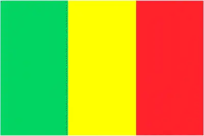 |
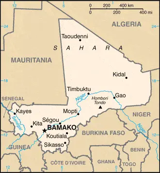
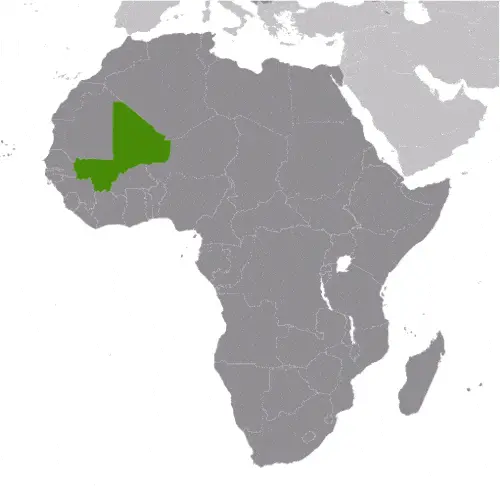
| Borderline map of Mali | Location map of Mali | Flag of Mali |
Google Maps and Detailed Facts of Mali (ML). This page lets you explore Mali and its border countries (Country Location: interior Western Africa, southwest of Algeria, north of Guinea, Cote d’Ivoire, and Burkina Faso, west of Niger) through detailed Satellite imagery – fast and easy as never before Google Maps.
Find comprehensive information about this country’s diversity below: Google maps, geography, economy, science, people, culture, environment, government, and history – All in One Wiki page.
There is also a Street View and free Driving Directions at your service. Your Google Satellite Map Sightseeing in Mali, in Africa, starts here at Driving Directions and Maps.com.
Mali Google Maps & Satellite Maps
The map below shows Mali with its cities, towns, highways, main roads, streets, and Street Views. To find a location, use the form below, type any city or place, view a simple map, and click the “show map” button.
The Google map above shows Mali with its location: Africa (geographic coordinates: 17 00 N, 4 00 W) and the international borders of Mali; total: 7,908 km. Border countries (total: 7): Algeria 1,359 km, Burkina Faso 1,325 km, Cote d’Ivoire 599 km, Guinea 1,062 km, Mauritania 2,236 km, Niger 838 km, Senegal 489 km; furthermore, it’s inland counties boundaries.
Hint: Look at the Street view in Mali or Africa. All you have to do is drag and pull the little yellow man (named: Pegman) on the Google map above the desired location. After that, whenever it is available (more than 50 countries globally), blue stripes will appear to show the photos and details from Google’s regularly updated data image base. In case if you have signed in to your Google account currently, you may have a look at the satellite map of this country/area as well.
The map of Mali, Africa, is for informational use only. No representation is made or warrantied given any map or its content by Driving Directions and Maps site. The user assumes all risks of using this Mali Google map and facts/wiki.
About Mali in detail
Where is Mali?
In case, Mali is looking on the map under the Coordinates 12 39 N 8 00 W otherwise in Africa, in interior Western Africa, southwest of Algeria, north of Guinea, Cote d’Ivoire, and Burkina Faso, west of Niger.
What is the capital city of Mali?
The capital city of Mali is Bamako.
What is the time in Bamako?
It is 5 hours ahead of Washington, D.C. during Standard Time; the timezone of Bamako is UTC 0.
What is the Internet code for Mali?
The Top Level Domain (TLD) for Mali is: .ml
What is the size of Mali?
The territory of Mali is total: 1,240,192 sq km; land: 1,220,190 sq km, water: 20,002 sq km.
If we want to describe the size of Mali’s territory is slightly less than twice the size of Texas.
If we would like to walk around and discover Mali, we can cover a total distance: 7,908 km.
What is the water coverage of Mali?
We have already mentioned what percentage of Mali is covered by water (see below), and this includes 0 km (landlocked country) coastline.
What is the climate like in Mali?
The climate of Mali is subtropical to arid: hot and dry (February to June): rainy, humid, and mild (June to November): cool and dry (November to February).
Geographical data of Mali
Mali’s elevation; mean elevation: 343 m, elevation extremes; lowest point: Senegal River 23 m, highest point: Hombori Tondo 1,155 m.
Mali’s specific geographical details include mostly flat to rolling northern plains covered by sand; savanna in the south, rugged hills in the northeast.
Suppose we would like to describe the countries location from a different perspective. In that case, it is safe to say, and easy to read from a map, Mali is a landlocked country, divided into three natural zones: the southern, cultivated Sudanese; the central, semiarid Sahelian; and the northern, arid Saharan.
Resources and land use of Mali
The country’s main mined products are gold, phosphates, kaolin, salt, limestone, uranium, gypsum, granite, hydropower. Note: bauxite, iron ore, manganese, tin, and copper deposits are known but not exploited. The population partly uses the earlier highlighted land territory and partly left in its natural state: agricultural land: 34.1%; arable land 5.6%; permanent crops 0.1%; permanent pasture 28.4%; forest: 10.2%; other: 55.7% (2011 estimate).
Population data of Mali
The number of inhabitants of Mali is 17,467,108 (July 2016 estimate).
If we examine the proportion of the population distribution, it is safe to say that the overwhelming majority of the population lives in the southern half of the country, with greater density along the border with Burkina Faso.
If we look at the proportion of the urbanized and barely populated areas, these are the figures: urban population: 39.9% of the total population (2015).
Most of the Mali population is concentrated in BAMAKO (capital), 2.515 million (2015).
Ethnicity in Mali
According to ethnicity details, the ethnic groups are Bambara 34.1%, Fulani (Peul) 14.7%, Sarakole 10.8%, Senufo 10.5%, Dogon 8.9%, Malinke 8.7%, Bobo 2.9%, Songhai 1.6%, Tuareg 0.9%, other Malian 6.1%, from member of Economic Community of West African States 0.3%, other 0.4% (2012-13 estimate).
Spoken languages in Mali
The spoken languages in Mali are the following: French (official language), Bambara 46.3%, Peul/Foulfoulbe 9.4%, Dogon 7.2%, Maraka/Soninke 6.4%, Malinke 5.6%, Sonrhai/Djerma 5.6%, Minianka 4.3%, Tamacheq 3.5%, Senoufo 2.6%, Bobo 2.1%, unspecified 0.7%, other 6.3%. Note: Mali has 13 national languages in addition to its official language (2009 estimate).
What are the most important religions in Mali?
During the general census, researchers examine the churches, according to this: Muslim 94.8%, Christian 2.4%, Animist 2%, none 0.5%, unspecified 0.3% (2009 estimate).
Further population data of Mali
The proportion of gender and age tells a lot about the society as follows 0-14 years: 47.27% (male 4,145,290 / female 4,110,642) 15-24 years: 19.19% (male 1,601,474 / female 1,751,161) 25-54 years: 26.82% (male 2,173,415 / female 2,511,844) 55-64 years: 3.76% (male 327,923 / female 329,296) 65 years and over: 2.95% (male 257,519 / female 258,544) (2016 estimate). It also a significant factor in a society the population growth rate, which in the case of Mali is 2.96% (2016 estimate).
The population growth rate is based on two elements, the birth, and the death rate. In Mali the birth rate is 44.4 births / 1,000 population (2016 estimate), the death rate 12.6 deaths / 1,000 population (2016 estimate).
In this day and age in developed societies, the first child borns later compared to the previous centuries and decades, so childbearing is extended. In Mali, the average age of mothers at the first childbirth is N/A.
Although the children’s birth is postponed in the best-case scenario, the parents can still see their kids grow as life expectancy also extended. In the case of Mali, these figures are. With the introduction of modern medicine, vaccinations, and the proper hygienic conditions, the infant mortality rate is in a steep decline. The infant mortality statistics in Mali are the following: N/A. Relevant data is the budget of healthcare, which is in the case of this country is 6.9% of GDP (2014).
Economic data of Mali
Suppose we would like to describe a country. We also have to mention its economy; Among the 25 poorest countries globally, Mali is a landlocked country that depends on gold mining and agricultural exports for revenue. The country’s fiscal status fluctuates with gold and agricultural commodity prices and the harvest; cotton and gold. Economic activity is mostly confined to the riverine area irrigated by the Niger River, and about 65% of its land area is desert or semidesert. About 10% of the population is nomadic, and about 80% of the labor force is engaged in farming and fishing. InduMali is developing its iron ore extraction industry to diversify foreign exchange earnings away from gold, but the pace will largely depend on global price trends. Mali’s economic performance has improved since 2013.
GDP is a prominent figure, as all the relevant calculations and statistics are based on it. GDP in Mali is $14.1 billion (2015 estimate).
Another important indicator is the rate of GDP growth, which in Mali is 5.3% (2016 estimate), 6% (2015 estimate) 7% (2014 estimate).
These statistics affect the world economy; remember, in 2015, the Chinese real GDP growth rate was worse than expected; The world markets fall, and the Chinese stock exchange was temporarily suspended.
A further major factor of a country’s economy, the GDP per capita. In Mali this is $2,300 (2016 estimate) $2,200 (2015 estimate) $2,200 (2014 estimate).
In the economy, the Trinity is in common places, such as agriculture, industry, and services.
What are the agricultural products Mali produces?
The main agricultural products of Mali aMali’scotton, millet, rice, corn, es, peanuts; cattle, sheep, goats.
Regarding the economy, the essential segments are food processing, construction, phosphate, and gold mining. The crucial and regularly mentioned GDP is based on food processing, construction, phosphate, and gold mining.
Drinking water source in Mali
It is essential to mention that – thanks to the development of the infrastructure -, the rate of potable water improved: urban: 96.5% of the population, rural: 64.1% of the population, total: 77% of the population. Unimproved: urban: 3.5% of the people, rural: 35.9% of the people, 23% of the population (2015 estimate).
The average number of childbirth in Mali
In Mali, the average delivery number is 5.95 children born / woman (2016 estimate).
Population, median age, migration, and citizenship in Mali
The population’s average age is 16.2 years; male: 15.5 years, female: 16.8 years (2016 estimate). The age of adulthood varies in every country of the world in Mali; it is 18 years of age, universal.
When we are experiencing an unprecedented scale of migration and globalization, it is an important factor in the number of new immigrants. In Mali is -2.2 migrant(s) / 1,000 population (2016 estimate). It is important to know how to apply for citizenship: citizenship by birth: no. Citizenship by descent only: at least one parent must be a citizen of Mali. Dual citizenship recognized: yes, the residency requirement for naturalization: 5 years.
Is Mali a safe destination? Healthcare services and infectious diseases in Mali
Many of the travelers are looking into the healthcare services and infectious diseases of their destinations. In Mali, the hospital beds’ density is 0.1 beds / 1,000 population (2010).
According to the WHO rating regarding Mali’s contagious diseases, the degree of risk: very high food or waterborne diseases: bacterial and protozoal diarrhea, hepatitis A, and typhoid fever vectorborne diseases: malaria and dengue fever water contact disease: schistosomiasis. Respiratory disease: meningococcal meningitis animal contact disease: rabies (2016).
However, HIV is not curable but maintainable. Let’s do not forget when the disease surfaced; it was a world threatening condition. Unfortunately, in some countries, it is still very high the number of infected patients and fatalities due to the disease.
In Mali, the number of HIV/AIDS deaths: N/A.
Regarding tourism obesity, not an important issue, but we have to mention health statistics, as it is the plague of the 20th and the 21st century. The rate of obese adults in Mali is 5.7% (2014).
What are the natural hazards in Mali? Is there any?
The most known natural risk in Mali is hot, dust-laden harmattan haze common during dry seasons; recurring droughts; occasional Niger River flooding.
More interesting facts about Mali
A few words about the past, as every country and society, is connected to its history; The Sudanese Republic and Senegal became independent of France in 1960 as the Mali Federation. When Senegal withdrew after only a few months, what formerly made up the Sudanese Republic was renamed Mali. Rule by dictatorship was brought to a close in 1991 by a military coup that ushered in a period of democratic government. President Alpha KONARE won Mali’s first two democratic presidential elections in 1992 and 1997. In keeping with Mali’s two-term constitutional limit, he stepped down in 2002 and was succeeded by Amadou Toumani TOURE, who was elected to a second term in a 2007 election widely judged to be free and fair. Malian returnees from Libya in 2011 exacerbated tensions in northern Mali, and Tuareg ethnic militias rebelled in January 2012. Low- and mid-level soldiers, frustrated with the rebellion’s poor handling, overthrew TOURE on 22 March.
Intensive mediation efforts led by the Economic Community of West African States (ECOWAS) returned power to a civilian administration in April with Interim President Dioncounda TRAORE’s appointment. The post-coup chaos led to rebels expelling the Malian military from the country’s three northern regions and allowed Islamic militants to set up strongholds. Hundreds of thousands of northern Malians fled the violence to southern Mali and neighboring countries, exacerbating regional food shortages in host communities. An international military intervention to retake the three northern regions began in January 2013, and within a month, most of the north had been retaken. In a democratic presidential election conducted in July and August of 2013, Ibrahim Boubacar KEITA was elected president. The Malian Government and northern armed groups signed an internationally-mediated peace accord in June 2015.
In every nation’s memory, some cornerstones placed the country on the timeline of history. The date of declaration of independence of Mali: 22 September 1960 (from France).
The flag and other symbols of Mali
The colors, symbols, and animals on the flag usually have a historical background or an important milestone or memory of the nation.
This case is not an exception either; three equal vertical bands of green (hoist side), yellow, and red. Note: uses the popular Pan-African colors of Ethiopia; the colors from left to right are the same as those of neighboring Senegal (which has an additional green central star) and the reverse of those on the flag neighboring Guinea.
Apart from the flag, the symbol of national unity is the national anthem. The anthem’s primary purpose is to share the nation’s core values, endeavors, and patriotic feelings.
National symbols of Mali: Great Mosque of Djenne; national colors: green, yellow, red.
Constitution of Mali
The existence of the nation is based on the constitution. Some constitutions knew worldwide, like the U.S. Constitution that was accepted on the 17th of September 1787, in Philadelphia, the United States of America’s Constitution.
It is not related to the declaration of independence that was stolen by Nicolas Cage in the movie National Treasure 🙂
What is the legal system of Mali?
Most of the time, the legal system of a country is the focus of lawyers. It is a common fact that there are two main approaches in the world, “the law in books” and “the law in action.”
In the Anglo-Saxon world, the practice is the “law in action,” while in the rest of the world, the law is based on Roman law, the “law in books.”
Mali’s legal system is a civil law system based on the French civil law model and influenced by customary law; judicial review of legislative acts in Constitutional Court.
It was Aristotle who founded the Theory of 3 separations of powers. In his view, these are the council of public affairs, the magistrates, and the justice system. The age of enlightenment was the time when terminologies have defined the way we still use them. In most democratic countries, the three authorities separated from each other. In dictatorships, the rules usually interweaved in one hand.
About the legislative branch of Mali, we can highlight the following structures unicameral National Assembly or Assemblee Nationale (147 seats; members directly elected in single-seat constituencies by absolute majority vote in two rounds if needed; members serve 5-year terms).
About the unemployment rate, labor force, and poverty line in Mali
One of the major problems of the 21st-century economy is unemployment. Governments are struggling to maintain a low level of the unemployment rate. Still, as a result of automation, the cheap 3rd world labor, and the outsourcing of workflow, these attempts fail. In Mali, the labor force is 6.283 million (2016 estimate). Please bear in mind that the population in Mali is total: 100 deaths / 1,000 live births; male: 106.6 deaths / 1,000 live births, female: 93.2 deaths / 1,000 live births (2016 estimate) – as we already mentioned above.
The rate of unemployment in Mali is 30% (2015 estimate).
Widely known that the gap between the rich and poor is widening on an enormous scale.
According to the 2017 shocking Oxfam report, the most affluent eight people’s fortune is equal to the wealth of the poorest half of the world’s population.
In Mali, the households’ income and consumption compared to the entire population: lowest 10%: 3.5% highest 10%: 25.8% (2010 estimate).
Another widely used indicator is the so-called GINI index, which measures the inequalities of statistical dispersion, but is mainly used for measuring the sharing of income and fortune.
The GINI index was named after its founder Corrado Gini, an Italian economist. Gini index has grades between 0-1, but often it is used on a percentage basis. It is 0 if the examined criteria territorial distribution is equal. It is one of the criteria concentrated on the territory. In Mali, the GINI index is .40,1 (2001).
The states usually set up a poverty line, which is more or less, is a subjective measure. It varies by country; its base is often the minimum pension, the incomes of the most deficient 20 percent, the X percent of income per capita Etc.
In Mali, the poverty line people are the lowest 10%: 3.5% highest 10%: 25.8% (2010 estimate).
About the budget and central governments debt of Mali
The available budget mainly defines the state’s economy. Mali’s budget is; revenues: $2.571 billion, expenditures: $3.112 billion (2016 estimate). Taxes and other revenues are 18.2% of GDP (2016 estimate).
The budget deficit (Budget surplus (+) or deficit (-)) is N/A.
The fiscal year in Mali is the calendar year.
In the country’s economy, we have to consider the public debt. Public debt is the consolidated sum of the state’s local, federal, and central government debt.
Inflation rate and prime lending rate in Mali
A few further interesting and relevant economic data are the following; Inflation rate: -0.3% (2016 estimate), 1.4% (2015 estimate), and the rate of the Commercial bank prime lending rate: 9.3% (31 December 2016 estimate).
Export/import partners and data of Mali
Mali, with the export of products, industrial tools, and other services, generates revenue. The export value in Mali is: $2.79 billion (2016 estimate), $2.513 billion (2015 estimate). The total revenue of these activities: cotton, gold, livestock.
The most important export partners of Mali are Switzerland 48.5%, China 9.4%, India 9.1%, Bangladesh 8%, Thailand 4.5%, Indonesia 4.4% (2015).
The most important imported products are petroleum, machinery and equipment, construction materials, foodstuffs, textiles, and the countries from where the import is coming: Cote d’Ivoire 9.9%, France 9.5%, Senegal 7.7%, China 7% (2015).
Renewable energies used in Mali
To suppress the pollution of the environment, renewable energies have to replace the fossil energy. The more the proportion of renewable energies in a country means more effort against pollution. Mali, the indicator of how much of the country’s produced energy is coming from the hydroelectric source, is 51.6% of total installed capacity (2012 estimate).
To indicate how much another renewable energy produced is 0% of total installed capacity (2012 estimate).
Telecommunication data of Mali, calling code
To maintain the economy, the development of a reliable and modern telecommunications infrastructure is crucial. We can say the following about Mali; domestic system improving; increasing use of local radio loops to extend network coverage to remote areas. Domestic: fixed-line subscribership remains less than 1 per 100 persons; mobile-cellular subscribership has risen sharply to over 130 per 100 persons. International: country code – 223; satellite communications center and fiber-optic links to neighboring countries; satellite earth stations – 2 Intelsat (1 Atlantic Ocean, 1 Indian Ocean) (2015).
Transport infrastructure in Mali
In the 21st century, we often say that the world has become small and there are no distances anymore. With widespread air travel when (sometimes) there are no visa restrictions, it is easy to reach other countries, but if the distance is not too long, we can also use railway or water transportation.
The number of airports in Mali: 25 (2013), and the number of heliports: 2 (2013).
The total length of the roadways in Mali: total: 22,474 km, paved: 5,522 km, unpaved: 16,952 km (2009).
The total length of the waterways in Mali: 1,800 km (downstream of Koulikoro; low water levels on the River Niger cause problems in dry years; in the months before the rainy season, the river is not navigable by commercial vessels) (2011).
Are you traveling to Mali?
If you plan to travel by plane to Mali, try our air ticket comparison site, where you can choose from hundreds of carriers and offers. Our application is scanning the market and shows you the best and the cheapest deals without any extra charge or commission.
Are you looking for a hotel, apartment another kind of accommodation in Mali, Africa? We are here to help you to find your accommodation from budget to luxury. Our search engine is scanning, regularly updating data from hundreds of accommodation websites and more than a million offers. You can quickly and easily find your hotel stay anywhere in the world, without any extra charge or commission.
Facts & data about Mali
Name of the country: conventional long way: the Republic of Mali, traditional short form: Mali, local long form: Republique de Mali, local short state: Mali, former: French Sudan and the Sudanese Republic. Note: name derives from the West African Mali Empire of the 13th to 16th centuries A.D.
| Abbreviation: Mali | Geographic coordinates: 17 00 N, 4 00 W |
Country Location: Africa |
| Capital of Mali: Bamako | GPS of the Capital: 12 39 N 8 00 W |
Position: interior Western Africa, southwest of Algeria, north of Guinea, Cote d’Ivoire, and Burkina Faso, west of Niger |
| Land area: total: 1,240,192 sq km; land: 1,220,190 sq km, water: 20,002 sq km | Terrain: mostly flat to rolling northern plains covered by sand; savanna in south, rugged hills in northeast |
Area comparative: slightly less than twice the size of Texas |
| Population: 17,467,108 (July 2016 estimate) | Population grow rate: 2.96% (2016 estimate) | Sex ratio: at birth: 1.03 male(s) / female, 0-14 years: 1.01 male(s) / female, 15-24 years: 0.91 male(s) / female, 25-54 years: 0.87 male(s) / female, 55-64 years: 1 male(s) / female, 65 years and over: 1 male(s) / female, total population: 0.95 male(s) / female (2016 estimate) |
| Exports: $2.79 billion (2016 estimate), $2.513 billion (2015 estimate) | Imports: $2.904 billion (2016 estimate), $2.744 billion (2015 estimate) | Import partners: Cote dIvoire 9.9%, France 9.5%, Senegal 7.7%, China 7% (2015) |
| Urbanization: urban population: 39.9% of the total population (2015) | Major urban area(s): BAMAKO (capital) 2.515 million (2015) | Median age: total: 16.2 years; male: 15.5 years, female: 16.8 years (2016 estimate) |
| Internet users: total: 1.753 million. Percent of the population: 10.3% (July 2015 estimate) | Telephones (fixed-lines): total subscriptions: 169,006. Subscriptions per 100 inhabitants: 1 (July 2015 estimate) | Telephones (mobile, cellular): total: 22.699 million. Subscriptions per 100 inhabitants: 134 (July 2015 estimate) |
| Unemployment rate: 30% (2015 estimate) | Nationality: Malian(s) adjective: Malian | National holidays: Independence Day, 22 September (1960) |
| Life expectancy at birth: total population: 55.8 years. Male: 53.9 years, female: 57.7 years (2016 estimate) | Total fertility rate: 5.95 children born / woman (2016 estimate) | Birthrate: 44.4 births / 1,000 population (2016 estimate) |
| Literacy: age 15 and over can read and write. Total population: 38.7%; male: 48.2%, female: 29.2% (2015 estimate) | Legal system: civil law system based on the French civil law model and influenced by customary law; judicial review of legislative acts in Constitutional Court | Suffrage: 18 years of age, universal |
| Industries: food processing; construction; phosphate and gold mining | Industrial production growth rate: 1.5% (2016 estimate) | GDP real growth rate: 5.3% (2016 estimate) 6% (2015 estimate) 7% (2014 estimate) |
Do you like this Mali Google maps™ & country information page?
Please do us a favor: Share or like this page using the icons at the top of the page. We also do encourage you to visit our Facebook page for more travel and country related information.
Many thanks for visiting and sharing this map & country information site!