
 |
 |
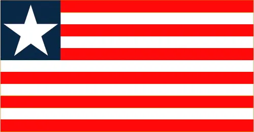 |
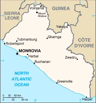
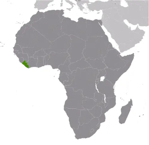
| Borderline map of Liberia | Location map of Liberia | Flag of Liberia |
Google Maps and Detailed Facts of Liberia (LR). This page lets you explore Liberia and its border countries (Country Location: Western Africa, bordering the North Atlantic Ocean, between Cote d’Ivoire and Sierra Leone) through detailed Satellite imagery – fast and easy as never before Google Maps.
Find comprehensive information about this country’s diversity below: Google maps, geography, economy, science, people, culture, environment, government, and history – All in One Wiki page.
There is also a Street View and free Driving Directions at your service. Your Google Satellite Map Sightseeing in Liberia, in Africa, starts here at Driving Directions and Maps.com.
Liberia Google Maps & Satellite Maps
The map below shows Liberia with its cities, towns, highways, main roads, streets, and Street Views. To find a location, use the form below, type any city or place, view a simple map, and click the “show map” button.
The Google map above shows Liberia with its location: Africa (geographic coordinates: 6 30 N, 9 30 W) and the international borders of Liberia; total: 1,667 km. Border countries (total: 3): Guinea 590 km, Cote d’Ivoire 778 km, Sierra Leone 299 km; furthermore, it’s inland counties boundaries.
Hint: Look at the Street view in Liberia or Africa. All you have to do is drag and pull the little yellow man (named: Pegman) on the Google map above the desired location. After that, whenever it is available (more than 50 countries globally), blue stripes will appear to show the photos and details from Google’s regularly updated data image base. In case if you have signed in to your Google account currently, you may have a look at the satellite map of this country/area as well.
The map of Liberia, Africa, is for informational use only. No representation is made or warrantied given any map or its content by Driving Directions and Maps site. The user assumes all risks of using this Liberia Google map and facts/wiki.
About Liberia in detail
Where is Liberia?
In case, Liberia is looking on the map under the Coordinates 6 18 N 10 48 W otherwise in Africa, in Western Africa, bordering the North Atlantic Ocean, between Cote d’Ivoire and Sierra Leone.
What is the capital city of Liberia?
The capital city of Liberia is Monrovia.
What is the time in Monrovia?
It is 5 hours ahead of Washington, D.C. during Standard Time; Monrovia’s timezone is UTC 0.
What is the Internet code for Liberia?
The Top Level Domain (TLD) for Liberia is: .lr
What is the size of Liberia?
The territory of Liberia is total: 111,369 sq km; land: 96,320 sq km, water: 15,049 sq km.
If we want to describe the size of the territory of Liberia is slightly larger than Tennessee.
If we would like to walk around and discover Liberia, we can cover a total distance: 1,667 km.
What is the water coverage of Liberia?
We have already mentioned what percentage of Liberia is covered by water (see below), and this includes 579 km coastline.
What is the climate like in Liberia?
Liberia’s climate is tropical: hot, humid: dry winters with hot days and cool to cold nights: wet, cloudy summers with frequent heavy showers.
Geographical data of Liberia
Liberia’s elevation; mean elevation: 243 m, elevation extremes; lowest point: Atlantic Ocean 0 m, highest point: Mount Wuteve 1,380 m.
Liberia’s specific geographical details include mostly flat to rolling coastal plains rising to roll plateau and low mountains in the northeast.
Suppose we would like to describe the countries location from a different perspective. In that case, it is safe to say, and easy to read from a map, Liberia is facing the Atlantic Ocean, the coastline is characterized by lagoons, mangrove swamps, and river-deposited sandbars; the inland grassy plateau supports limited agriculture.
Resources and land use of Liberia
The country’s main mined products are iron ore, timber, diamonds, gold, hydropower. The population partly uses the earlier highlighted land territory and partly left in its natural state: agricultural land: 28.1%; arable land 5.2%; permanent crops 2.1%; permanent pasture 20.8%; forest: 44.6%; other: 27.3% (2011 estimate).
Population data of Liberia
The number of inhabitants of Liberia is 4,299,944 (July 2016 estimate).
If we examine the proportion of the population distribution, it is safe to say that N/A.
If we look at the proportion of the urbanized and barely populated areas, these are the figures: urban population: 49.7% of the total population (2015).
Most of the population in Liberia is concentrated in MONROVIA (capital) 1.264 million (2015).
Ethnicity in Liberia
According to ethnicity details, the ethnic groups are Kpelle 20.3%, Bassa 13.4%, Grebo 10%, Gio 8%, Mano 7.9%, Kru 6%, Lorma 5.1%, Kissi 4.8%, Gola 4.4%, other 20.1% (2008 Census).
Spoken languages in Liberia
Liberia’s spoken languages are English 20% (official language), some 20 ethnic group languages, few of which can be written or used in correspondence.
What are the most important religions in Liberia?
During the general census, researchers examine the churches, according to this: Christian 85.6%, Muslim 12.2%, Traditional 0.6%, other 0.2%, none 1.4% (2008 Census).
Further population data of Liberia
The proportion of gender and age tells a lot about the society as follows 0-14 years: 42.3% (male 917,354 / female 901,627) 15-24 years: 18.9% (male 400,013 / female 412,869) 25-54 years: 31.32% (male 669,630 / female 677,321) 55-64 years: 4.3% (male 89,264 / female 95,519) 65 years and over: 3.17% (male 66,658 / female 69,689) (2016 estimate). It also a significant factor in a society the population growth rate, which in the case of Liberia is 2.44% (2016 estimate).
The population growth rate is based on two elements, the birth, and the death rate. In Liberia the birth rate is 33.9 births / 1,000 population (2016 estimate), the death rate 9.5 deaths / 1,000 population (2016 estimate).
In this day and age in developed societies, the first child borns later compared to the previous centuries and decades, so childbearing is extended. In Liberia, the average age of mothers at the first childbirth is N/A.
Although the children’s birth is postponed in the best-case scenario, the parents can still see their kids grow as life expectancy also extended. In the case of Liberia, these figures are. With the introduction of modern medicine, vaccinations, and the proper hygienic conditions, the infant mortality rate is in a steep decline. The infant mortality statistics in Liberia are the following: N/A. Relevant data is the budget of healthcare, which is in the case of this country is 10% of GDP (2014).
Economic data of Liberia
Suppose we would like to describe a country, we also have to mention its economy; Liberia is a low-income country that relies heavily on foreign assistance. It is richly endowed with water, mineral resources, forests, and a climate favorable to agriculture. Its principal exports are iron ore, rubber, gold, and timber. In the 1990s and early 2000s, civil war and government mismanagement destroyed much of Liberia’s economy, especially infrastructure in and around the capital. Revitalizing the economy in the future will depend on increasing investment and trade, higher global commodity prices, sustained foreign aid and remittances, development of infrastructure and institutions, and maintaining political stability and security.
GDP is a prominent figure, as all the relevant calculations and statistics are based on it. GDP in Liberia is $2.168 billion (2015 estimate).
Another important indicator is the rate of GDP growth, which in Liberia is 2% (2016 estimate) 0% (2015 estimate) 0.7% (2014 estimate).
These statistics affect the world economy; remember, in 2015, the Chinese real GDP growth rate was worse than expected; The world markets fall, and the Chinese stock exchange was temporarily suspended.
A further major factor of a country’s economy, the GDP per capita. In Liberia this is $900 (2016 estimate) $900 (2015 estimate) $900 (2014 estimate).
In the economy, the Trinity is in common places, such as agriculture, industry, and services.
What are the agricultural products Liberia produces?
Liberia’s main agricultural products are rubber, coffee, cocoa, rice, cassava (manioc, tapioca), palm oil, sugarcane, bananas; sheep, goats; timber.
The essential segments are mining (iron ore), rubber processing, palm oil processing, timber, diamonds. The crucial and regularly mentioned GDP is based on mining (iron ore), rubber processing, palm oil processing, timber, diamonds.
Drinking water source in Liberia
It is essential to mention that – thanks to the development of the infrastructure -, the rate of potable water improved: urban: 88.6% of the population, rural: 62.6% of the population, total: 75.6% of the population. Unimproved: urban: 11.4% of the people, rural: 37.4% of the people, total: 24.4% of the population (2015 estimate).
The average number of childbirth in Liberia
In Liberia, the average delivery number is 4.6 children born / woman (2016 estimate).
Population, median age, migration, and citizenship in Liberia
The population’s average age is 18.3 years; male: 18.1 years, female: 18.5 years (2016 estimate). The age of adulthood varies in every country of the world in Liberia; it is 18 years of age, universal.
When we are experiencing an unprecedented scale of migration and globalization, it is an important factor in the number of new immigrants. In Liberia is 0 migrant(s) / 1,000 population (2016 estimate). It is important to know how to apply for citizenship: citizenship by birth: no. Citizenship by descent only: at least one parent must be a citizen of Liberia. Dual citizenship recognized: no—residency requirement for naturalization: 2 years.
Is Liberia a safe destination? Healthcare services and infectious diseases in Liberia
Many of the travelers are looking into the healthcare services and infectious diseases of their destinations. In Liberia, the hospital beds’ density is 0.8 beds / 1,000 population (2010).
According to the WHO rating regarding contagious diseases in Liberia, the degree of risk: very high food or waterborne diseases: bacterial and protozoal diarrhea, hepatitis A, and typhoid fever vectorborne diseases: malaria, dengue fever, and yellow fever water contact disease: schistosomiasis aerosolized dust or soil contact disease: Lassa fever animal contact disease: rabies (2016).
However, HIV is not curable but maintainable. Let’s do not forget when the disease surfaced; it was a world threatening condition. Unfortunately, in some countries, it is still very high the number of infected patients and fatalities due to the disease.
In Liberia, the number of HIV/AIDS deaths: N/A.
Regarding tourism obesity, not an important issue, but we have to mention health statistics, as it is the plague of the 20th and the 21st century. The rate of obese adults in Liberia is 5.8% (2014).
What are the natural hazards in Liberia? Is there any?
Liberia’s most known natural risk is dust-laden harmattan winds blow from the Sahara (December to March).
More interesting facts about Liberia
A few words about the past, as every country and society, are connected to its history; Settlement of freed slaves from the US in today Liberia began in 1822; by 1847, the Americo-Liberians were able to establish a republic. William TUBMAN, president from 1944-71, did much to promote foreign investment and bridge the economic, social, and political gaps between the descendants of the original settlers and the interior inhabitants.
In 1980, a military coup led by Samuel DOE ushered in a decade of authoritarian rule. In December 1989, Charles TAYLOR launched a rebellion against DOE’s regime that led to a prolonged civil war in which DOE was killed. A period of relative peace in 1997 allowed for an election that brought TAYLOR to power, but major fighting resumed in 2000. An August 2003 peace agreement ended the war. It prompted the resignation of former president Charles TAYLOR, who was convicted by the UN-backed Special Court for Sierra Leone in The Hague for his involvement in Sierra Leone’s civil war.
After two years of rule by a transitional government, democratic elections in late 2005 brought President Ellen JOHNSON SIRLEAF to power. She subsequently won reelection in 2011 and remains challenged to rebuild Liberia’s economy, particularly following the 2014-15 Ebola epidemic, and to reconcile a nation still recovering from 14 years of fighting. The UN Security Council in September 2015 passed Resolution 2239, which renewed the mandate for the UN Mission in Liberia for another year. In July 2016, the UN handed over peacekeeping responsibility to Liberia and reduced the UN troop presence, which now serves a support role.
In every nation’s memory, some cornerstones placed the country on the timeline of history. The date of declaration of independence of Liberia: 26 July 1847.
The flag and other symbols of Liberia
The colors, symbols, and animals on the flag usually have a historical background or an important milestone or memory of the nation.
This case is not an exception either; 11 equal horizontal stripes of red (top and bottom) alternating with white; a white five-pointed star appears on a blue square in the upper hoist-side corner; the lines symbolize the signatories of the Liberian Declaration of Independence; the blue square represents the African mainland, and the star represents the freedom granted to the ex-slaves; according to the constitution, the blue color signifies liberty, justice, and fidelity, the white color purity, cleanliness, and guilelessness, and the red color steadfastness, valor, and fervor. Note: the design is based on the US flag.
Apart from the flag, the symbol of national unity is the national anthem. The anthem’s primary purpose is to share the nation’s core values, endeavors, and patriotic feelings.
National symbols of Liberia: white star; national colors: red, white, blue.
Constitution of Liberia
The existence of the nation is based on the constitution. Some constitutions knew worldwide, like the U.S. Constitution that was accepted on the 17th of September 1787, in Philadelphia, the United States of America’s Constitution.
It is not related to the declaration of independence that was stolen by Nicolas Cage in the movie National Treasure 🙂
What is the legal system of Liberia?
Most of the time, the legal system of a country is the focus of lawyers. It is a common fact that there are two main approaches in the world, “the law in books” and “the law in action.”
In the Anglo-Saxon world, the practice is the “law in action,” while in the rest of the world, the law is based on Roman law, the “law in books.”
Liberia’s legal system is a mixed legal system of common law (based on Anglo-American law) and customary law.
It was Aristotle who founded the Theory of 3 separations of powers. In his view, these are the council of public affairs, the magistrates, and the justice system. The age of enlightenment was the time when terminologies have defined the way we still use them. In most democratic countries, the three authorities separated from each other. In dictatorships, the rules usually interweaved in one hand.
About the legislative branch of Liberia, we can highlight the following structures bicameral National Assembly consists of the Senate (30 seats; members directly elected in 15 two-seat constituencies by simple majority vote to serve 9-year staggered terms with half the membership renewed at 3- and 6-year intervals; eligible for a second term; and the House of Representatives (73 seats; members directly elected in single-seat constituencies by a simple majority vote to serve 6-year terms; eligible for a second term).
About the unemployment rate, labor force, and poverty line in Liberia
One of the major problems of the 21st-century economy is unemployment. Governments are struggling to maintain a low level of the unemployment rate. Still, as a result of automation, the cheap 3rd world labor, and the outsourcing of workflow, these attempts fail. In Liberia, the labor force is 1.654 million (2016 estimate). Please bear in mind that the population in Liberia is total: 65.8 deaths / 1,000 live births; male: 69.9 deaths / 1,000 live births, female: 61.5 deaths / 1,000 live births (2016 estimate) – as we already mentioned above.
The rate of unemployment in Liberia is 85% (2003 estimate).
Widely known that the gap between the rich and poor is widening on an enormous scale.
According to the 2017 shocking Oxfam report, the most affluent eight people’s fortune is equal to the wealth of the poorest half of the world’s population.
In Liberia, the households’ income and consumption compared to the entire population: lowest 10%: 2.4% highest 10%: 30.1% (2007).
Another widely used indicator is the so-called GINI index, which measures the inequalities of statistical dispersion, but is mainly used for measuring the sharing of income and fortune.
The GINI index was named after its founder Corrado Gini, an Italian economist. Gini index has grades between 0-1, but often it is used on a percentage basis. It is 0 if the examined criteria territorial distribution is equal. It is one of the criteria concentrated on the territory. In Liberia, the GINI index is N/A.
The states usually set up a poverty line, which is more or less, is a subjective measure. It varies by country; its base is often the minimum pension, the incomes of the most deficient 20 percent, the X percent of income per capita Etc.
In Liberia, the poverty line people are the lowest 10%: 2.4% highest 10%: 30.1% (2007).
About the budget and central governments debt of Liberia
The available budget mainly defines the state’s economy. Liberia’s budget is; revenues: $613 million, expenditures: $743 million (2016 estimate). Taxes and other revenues are 28.3% of GDP (2016 estimate).
The budget deficit (Budget surplus (+) or deficit (-)) is N/A.
The fiscal year in Liberia is the calendar year.
In the country’s economy, we have to consider the public debt. Public debt is the consolidated sum of the state’s local, federal, and central government debt.
Inflation rate and prime lending rate in Liberia
A few further interesting and relevant economic data are the following; Inflation rate: 6.3% (2016 estimate), 7.7% (2015 estimate), and the rate of the Commercial bank prime lending rate: 13.6% (31 December 2016 estimate).
Export/import partners and data of Liberia
Liberia, with the export of products, industrial tools, and other services, generates revenue. Liberia’s export value is: $363.9 million (2016 estimate), $330.8 million (2015 estimate). The total revenue of these activities: rubber, timber, iron, diamonds, cocoa, coffee.
Liberia’s most important export partners are Poland 32.9%, China 20.7%, India 9.3%, US 5.1%, Greece 4.7%, France 4.3% (2015).
The most important imported products are fuels, chemicals, machinery, transportation equipment, manufactured goods, foodstuffs, and the countries where the import is coming: Singapore 28.7%, China 16%, South Korea 15.3%, Japan 10.3%, Philippines 6.6% (2015).
Renewable energies used in Liberia
To suppress the pollution of the environment, renewable energies have to replace the fossil energy. The more the proportion of renewable energies in a country means more effort against pollution. Liberia, the indicator of how much of the country’s produced energy is coming from the hydroelectric source, is 0% of total installed capacity (2012 estimate).
To indicate how much another renewable energy produced is 0% of total installed capacity (2012 estimate).
Telecommunication data of Liberia, calling code
To maintain the economy, the development of a reliable and modern telecommunications infrastructure is crucial. We can say the following about Liberia; the limited services available are found almost exclusively in the capital, Monrovia; fixed-line service stagnant and extremely limited; telephone coverage extended to several other towns and rural areas by four mobile-cellular network operators. Domestic: mobile-cellular subscription base growing and teledensity reached 85 per 100 persons in 2015international: country code – 231; satellite earth station – 1 Intelsat (Atlantic Ocean) (2015).
Transport infrastructure in Liberia
In the 21st century, we often say that the world has become small and there are no distances anymore. With widespread air travel when (sometimes) there are no visa restrictions, it is easy to reach other countries, but if the distance is not too long, we can also use railway or water transportation.
The number of airports in Liberia: 29 (2013), and the number of heliports: N/A.
The total length of the roadways in Liberia: total: 10,600 km, paved: 657 km, unpaved: 9,943 km (2000).
The total length of the waterways in Liberia: N/A.
Are you traveling to Liberia?
If you plan to travel by plane to Liberia, try our air ticket comparison site, where you can choose from hundreds of carriers and offers. Our application is scanning the market and shows you the best and the cheapest deals without any extra charge or commission.
Are you looking for a hotel, apartment another kind of accommodation in Liberia, Africa? We are here to help you to find your accommodation from budget to luxury. Our search engine is scanning, regularly updating data from hundreds of accommodation websites and more than a million offers. You can quickly and easily find your hotel stay anywhere in the world, without any extra charge or commission.
Facts & data about Liberia
Name of the country: conventional long way: the Republic of Liberia, traditional short form: Liberia, etymology: name derives from the Latin word “liber” meaning “free”; so named because the nation was created as a homeland for liberated African-American slaves.
| Abbreviation: Liberia | Geographic coordinates: 6 30 N, 9 30 W |
Country Location: Africa |
| Capital of Liberia: Monrovia | GPS of the Capital: 6 18 N 10 48 W |
Position: Western Africa, bordering the North Atlantic Ocean, between Cote d’Ivoire and Sierra Leone |
| Land area: total: 111,369 sq km; land: 96,320 sq km, water: 15,049 sq km | Terrain: mostly flat to rolling coastal plains rising to rolling plateau and low mountains in northeast |
Area comparative: slightly larger than Tennessee |
| Population: 4,299,944 (July 2016 estimate) | Population grow rate: 2.44% (2016 estimate) | Sex ratio: at birth: 1.03 male(s) / female, 0-14 years: 1.02 male(s) / female, 15-24 years: 0.97 male(s) / female, 25-54 years: 0.99 male(s) / female, 55-64 years: 0.93 male(s) / female, 65 years and over: 0.97 male(s) / female, total population: 0.99 male(s) / female (2016 estimate) |
| Exports: $363.9 million (2016 estimate), $330.8 million (2015 estimate) | Imports: $1.25 billion (2016 estimate), $2.232 billion (2015 estimate) | Import partners: Singapore 28.7%, China 16%, South Korea 15.3%, Japan 10.3%, Philippines 6.6% (2015) |
| Urbanization: urban population: 49.7% of the total population (2015) | Major urban area(s): MONROVIA (capital) 1.264 million (2015) | Median age: total: 18.3 years; male: 18.1 years, female: 18.5 years (2016 estimate) |
| Internet users: total: 248,000. Percent of the population: 5.9% (July 2015 estimate) | Telephones (fixed-lines): total subscriptions: 9,000. Subscriptions per 100 inhabitants: less than 1 (July 2015 estimate) | Telephones (mobile, cellular): total: 3.652 million. Subscriptions per 100 inhabitants: 87 (July 2015 estimate) |
| Unemployment rate: 85% (2003 estimate) | Nationality: Liberian(s) adjective: Liberian | National holidays: Independence Day, 26 July (1847) |
| Life expectancy at birth: total population: 59 years. Male: 57.3 years, female: 60.8 years (2016 estimate) | Total fertility rate: 4.6 children born / woman (2016 estimate) | Birthrate: 33.9 births / 1,000 population (2016 estimate) |
| Literacy: age 15 and over can read and write. Total population: 47.6%; male: 62.4%, female: 32.8% (2015 estimate) | Legal system: mixed legal system of common law (based on Anglo-American law) and customary law | Suffrage: 18 years of age, universal |
| Industries: mining (iron ore), rubber processing, palm oil processing, timber, diamonds | Industrial production growth rate: 2.4% (2016 estimate) | GDP real growth rate: 2% (2016 estimate) 0% (2015 estimate) 0.7% (2014 estimate) |
Do you like this Liberia Google maps™ & country information page?
Please do us a favor: Share or like this page using the icons at the top of the page. We also do encourage you to visit our Facebook page for more travel and country related information.
Many thanks for visiting and sharing this map & country information site!