
 |
 |
 |
| Borderline map of Equatorial Guinea | Location map of Equatorial Guinea | Flag of Equatorial Guinea |
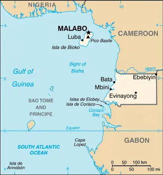
Google Maps and Detailed Facts of Equatorial Guinea (GQ). This page lets you explore Equatorial Guinea and its border countries (Country Location: Central Africa, bordering the Bight of Biafra, between Cameroon and Gabon) through detailed Satellite imagery – fast and easy as never before Google Maps.
Find comprehensive information about this country’s diversity below: Google maps, geography, economy, science, people, culture, environment, government, and history – All in One Wiki page.
There is also a Street View and free Driving Directions at your service. Your Google Satellite Map Sightseeing in Equatorial Guinea, in Africa, starts here at Driving Directions and Maps.com.
Equatorial Guinea Google Maps & Satellite Maps
The map below shows Equatorial Guinea with its cities, towns, highways, main roads, streets, and Street Views. To find a location, use the form below, type any city or place, view a simple map, and click the “show map” button.
The Google map above shows Equatorial Guinea with its location: Africa (geographic coordinates: 2 00 N, 10 00 E) and the international borders of Equatorial Guinea; total: 528 km. Border countries (total: 2): Cameroon 183 km, Gabon 345 km; furthermore, it’s inland counties boundaries.
Hint: Look at the Street view in Equatorial Guinea or Africa. All you have to do is drag and pull the little yellow man (named: Pegman) on the Google map above the desired location. After that, whenever it is available (more than 50 countries globally), blue stripes will appear to show the photos and details from Google’s regularly updated data image base. In case if you have signed in to your Google account currently, you may have a look at the satellite map of this country/area as well.
The map of Equatorial Guinea, Africa, is for informational use only. No representation is made or warrantied given any map or its content by Driving Directions and Maps site. The user assumes all risks of using this Equatorial Guinea Google map and facts/wiki.
About Equatorial Guinea in detail
Where is Equatorial Guinea?
Equatorial Guinea, if you are looking on the map under the Coordinates 3 45 N 8 47 E otherwise in Africa, in Central Africa, bordering the Bight of Biafra, between Cameroon and Gabon.
What is the capital city of Equatorial Guinea?
The capital city of Equatorial Guinea is Malabo.
What is the time in Malabo?
It is 6 hours ahead of Washington, D.C. during Standard Time; Malabo’s timezone is UTC+1.
What is the Internet code for Equatorial Guinea?
The Top Level Domain (TLD) for Equatorial Guinea is: .gq
What is the size of Equatorial Guinea?
The territory of Equatorial Guinea is total: 28,051 sq km; land: 28,051 sq km, water: 0 sq km.
If we want to describe the size of the territory of Equatorial Guinea is somewhat smaller than Maryland.
If we would like to walk around and discover Equatorial Guinea, we can cover a total distance: 528 km.
What is the water coverage of Equatorial Guinea?
We have already mentioned what percentage of Equatorial Guinea is covered by water (see below), and this includes 296 km coastline.
What is the climate like in Equatorial Guinea?
The climate of Equatorial Guinea is tropical: always hot, humid.
Geographical data of Equatorial Guinea
The elevation of Equatorial Guinea; mean elevation: 577 m, elevation extremes; lowest point: Atlantic Ocean 0 m, highest point: Pico Basile 3,008 m.
The specific geographical details of Equatorial Guinea include coastal plains rise to interior hills; islands are volcanic.
Suppose we would like to describe the countries location from a different perspective. In that case, it is safe to say, and easy to read from a map, Equatorial Guinea is insular and continental regions widely separated.
Resources and land use of Equatorial Guinea
The country’s main mined products are petroleum, natural gas, timber, gold, bauxite, diamonds, tantalum, sand and gravel, clay. The population partly uses the earlier highlighted land territory and partly left in its natural state: agricultural land: 10.1%; arable land 4.3%; permanent crops 2.1%; permanent pasture 3.7%; forest: 57.5%; other: 32.4% (2011 estimate).
Population data of Equatorial Guinea
The number of inhabitants of Equatorial Guinea is 759,451 (July 2016 estimate).
If we look at the proportion of the urbanized and barely populated areas, these are the figures: urban population: 39.9% of the total population (2015).
Most of the population in Equatorial Guinea is concentrated in MALABO (capital) 145,000 (2014).
Ethnicity in Equatorial Guinea
According to ethnicity details, the ethnic groups are Fang 85.7%, Bubi 6.5%, Mdowe 3.6%, Annobon 1.6%, Bujeba 1.1%, other 1.4% (1994 census).
Spoken languages in Equatorial Guinea
The spoken languages in Equatorial Guinea are the following: Spanish (official language) 67.6%, other (includes French (official language), Fang, Bubi) 32.4% (1994 census).
What are the most important religions in Equatorial Guinea?
According to this general census, researchers examine the churches: nominally Christian and predominantly Roman Catholic, pagan practices.
Further population data of Equatorial Guinea
The proportion of gender and age tells a lot about the society as follows 0-14 years: 40.15% (male 154,896 / female 150,010) 15-24 years: 19.63% (male 75,914 / female 73,194) 25-54 years: 31.94% (male 120,999 / female 121,587) 55-64 years: 4.3% (male 14,052 / female 18,583) 65 years and over: 3.98% (male 12,627 / female 17,589) (2016 estimate). It also a significant factor in a society the population growth rate, which in the case of Equatorial Guinea is 2.48% (2016 estimate).
The population growth rate is based on two elements, the birth, and the death rate. In Equatorial Guinea the birth rate is 32.8 births / 1,000 population (2016 estimate), the death rate 8 deaths / 1,000 population (2016 estimate).
In this day and age in developed societies, the first child borns later compared to the previous centuries and decades, so childbearing is extended. In Equatorial Guinea, the average age of mothers at the first childbirth is N/A.
Although the children’s birth is postponed in the best-case scenario, the parents can still see their kids grow as life expectancy also extended. In the case of Equatorial Guinea, these figures are. With the introduction of modern medicine, vaccinations, and the proper hygienic conditions, the infant mortality rate is in a steep decline. The infant mortality statistics in Equatorial Guinea are the following: N/A. Relevant data is the budget of healthcare, which is in the case of this country is 3.8% of GDP (2014).
Economic data of Equatorial Guinea
Suppose we would like to describe a country, we also have to mention its economy; Exploitation of oil and gas deposits, beginning in the 1990s, has driven economic growth in Equatorial Guinea, allowing per capita GDP (at purchasing power parity) to rise to over $38,700 in 2016. Forestry and farming are minor components of GDP. AlthoughForeign assistance programs by the World Bank and the IMF have been cut since 1993 because of corruption and mismanagement. As a middle-income country, Equatorial Guinea is now ineligible for most donor assistance. Equatorial Guinea hosted two economic diversification symposia in 2014 that focused on attracting investment in five sectors: agriculture and animal ranching, fishing, mining and petrochemicals, tourism, and financial services.
GDP is a prominent figure, as all the relevant calculations and statistics are based on it. GDP in Equatorial Guinea is $11.64 billion (2015 estimate).
Another important indicator is the rate of GDP growth, which in Equatorial Guinea is -9.9% (2016 estimate) -7.4% (2015 estimate) -0.5% (2014 estimate).
These statistics affect the world economy; remember, in 2015, the Chinese real GDP growth rate was worse than expected; The world markets fall, and the Chinese stock exchange was temporarily suspended.
A further major factor of a country’s economy, the GDP per capita. In Equatorial Guinea this is $38,700 (2016 estimate) $44,100 (2015 estimate) $48,900 (2014 estimate).
In the economy, the Trinity is in common places, such as agriculture, industry, and services.
What are the agricultural products Equatorial Guinea produces?
The main agricultural products of Equatorial Guinea are coffee, cocoa, rice, yams, cassava (manioc, tapioca), bananas, palm oil nuts; livestock; timber.
Regarding the economy, the essential segments are petroleum, natural gas, sawmilling. The crucial and regularly mentioned GDP is based on petroleum, natural gas, sawmilling.
Drinking water source in Equatorial Guinea
It is essential to mention that – thanks to the development of the infrastructure -, the rate of potable water improved: urban: 72.5% of the population, rural: 31.5% of the population, total: 47.9% of the population. Unimproved: urban: 27.5% of the population, rural: 68.5% of the population, total: 52.1% of the population (2015 estimate).
The average number of childbirth in Equatorial Guinea
In Equatorial Guinea, the average delivery number is 4.48 children born / woman (2016 estimate).
Population, median age, migration, and citizenship in Equatorial Guinea
The population’s average age is 19.6 years; male: 19.1 years, female: 20.1 years (2016 estimate). The age of adulthood varies in every country of the world in Equatorial Guinea; it is 18 years of age, universal.
When we are experiencing an unprecedented scale of migration and globalization, it is an important factor in the number of new immigrants. In Equatorial Guinea is 0 migrant(s) / 1,000 population (2016 estimate). It is important to know how to apply for citizenship: citizenship by birth: no. Citizenship by descent only: at least one parent must be a citizen of Equatorial Guinea. Dual citizenship recognized: no—residency requirement for naturalization: 10 years.
Is Equatorial Guinea a safe destination? Healthcare services and infectious diseases in Equatorial Guinea
Many of the travelers are looking into the healthcare services and infectious diseases of their destinations. In Equatorial Guinea, the hospital beds’ density is 2.1 beds / 1,000 population (2010).
According to the WHO rating regarding contagious diseases in Equatorial Guinea, the degree of risk: very high food or waterborne diseases: bacterial and protozoal diarrhea, hepatitis A, and typhoid fever vectorborne disease: malaria and dengue fever animal contact disease: rabies (2016).
However, HIV is not curable but maintainable. Let’s do not forget when the disease surfaced; it was a world threatening condition. Unfortunately, in some countries, it is still very high the number of infected patients and fatalities due to the disease.
In Equatorial Guinea, the number of HIV/AIDS deaths: N/A.
Regarding tourism obesity, not an important issue, but we have to mention health statistics, as it is the plague of the 20th and the 21st century. The rate of obese adults in Equatorial Guinea is 16.2% (2014).
What are the natural hazards in Equatorial Guinea? Is there any?
The most known natural risk in Equatorial Guinea are violent windstorms; flash floods volcanism: Santa Isabel (elevation 3,007 m), which last erupted in 1923, is the country’s only historically active volcano; Santa Isabel, along with two dormant volcanoes, form Bioko Island in the Gulf of Guinea.
More interesting facts about Equatorial Guinea
A few words about the past, as every country and society, is connected to its history; Equatorial Guinea gained independence in 1968 after 190 years of Spanish rule; it is one of the smallest countries in Africa, consisting of a mainland territory and five inhabited islands. Malabo’s capital is located on the island of Bioko, approximately 25 km from the Cameroonian coastline in the Gulf of Guinea. Between 1968 and 1979, autocratic President Francisco MACIAS NGUEMA virtually destroyed all of its political, economic, and social institutions before being deposed by his nephew Teodoro OBIANG NGUEMA MBASOGO in a coup. President OBIANG has ruled since October 1979 and was re-elected in 2016. Although nominally a constitutional democracy since 1991, presidential and legislative elections since 1996 have generally been labeled as flawed.
The president exerts almost total control over the political system and has placed legal and bureaucratic barriers that prevent political opposition. Equatorial Guinea has experienced rapid economic growth due to the discovery of large offshore oil reserves, and in the last decade, has become Sub-Saharan Africa’s third-largest oil exporter. Despite the country’s economic windfall from oil production, resulting in a massive increase in government revenue in recent years, the drop in global oil prices has placed a significant strain on the state budget. Equatorial Guinea diversifies its economy and increases foreign investment despite limited improvements in the population’s living standards. Equatorial Guinea is the host of major regional and international conferences and seeks a greater regional affairs role.
In every nation’s memory, some cornerstones placed the country on the timeline of history. The date of declaration of independence of Equatorial Guinea: 12 October 1968 (from Spain).
The flag and other symbols of Equatorial Guinea
The colors, symbols, and animals on the flag usually have a historical background or an important milestone or memory of the nation.
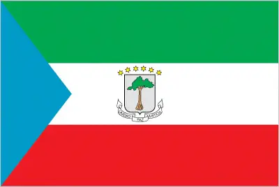
This case is not an exception either; three equal horizontal bands of green (top), white, and red, with a blue isosceles triangle based on the hoist side and the coat of arms centered in the white band; the coat of arms has six yellow six-pointed stars (representing the mainland and five offshore islands) above a gray shield bearing a silk-cotton tree and below which is a scroll with the motto UNIDAD, PAZ, JUSTICIA (Unity, Peace, Justice); green symbolizes the jungle and natural resources, blue represents the sea that connects the mainland to the islands, white stands for peace, and red recalls the fight for independence.
Apart from the flag, the symbol of national unity is the national anthem. The anthem’s primary purpose is to share the nation’s core values, endeavors, and patriotic feelings.
National symbols of Equatorial Guinea: silk cotton tree; national colors: green, white, red, blue.
Constitution of Equatorial Guinea
The existence of the nation is based on the constitution. Some constitutions knew worldwide, like the U.S. Constitution that was accepted on the 17th of September 1787, in Philadelphia, the United States of America’s Constitution.
It is not related to the declaration of independence that was stolen by Nicolas Cage in the movie National Treasure 🙂
What is the legal system of Equatorial Guinea?
Most of the time, the legal system of a country is the focus of lawyers. It is a common fact that there are two main approaches in the world, “the law in books” and “the law in action.”
In the Anglo-Saxon world, the practice is the “law in action,” while in the rest of the world, the law is based on Roman law, the “law in books.”
The legal system of Equatorial Guinea is a mixed system of civil and customary law.
It was Aristotle who founded the Theory of 3 separations of powers. In his view, these are the council of public affairs, the magistrates, and the justice system. The age of enlightenment was the time when terminologies have defined the way we still use them. In most democratic countries, the three authorities separated from each other. In dictatorships, the rules usually interweaved in one hand.
About the legislative branch of Equatorial Guinea, we can highlight the following structures bicameral National Assembly or Asemblea Nacional, formerly the unicameral Parliament, consists of the Senate or Senado (70 seats; 55 members directly elected by simple majority vote and 15 appointed by the president) and the House of People’s Representatives or Camara de Representantes del Pueblo (100 seats; members directly elected in multi-seat constituencies by proportional representation vote to serve 5-year terms); note – the constitutional referendum of 2011 established the Senate and was implemented at the time of the May 2013 elections.
About the unemployment rate, labor force, and poverty line in Equatorial Guinea
One of the major problems of the 21st-century economy is unemployment. Governments are struggling to maintain a low level of the unemployment rate. Still, as a result of automation, the cheap 3rd world labor, and the outsourcing of workflow, these attempts fail. In Equatorial Guinea, the labor force is 195,200 (2007 estimate). Please bear in mind that the population in Equatorial Guinea is total: 67.2 deaths / 1,000 live births; male: 68.2 deaths / 1,000 live births, female: 66.1 deaths / 1,000 live births (2016 estimate) – as we already mentioned above.
The rate of unemployment in Equatorial Guinea is 22.3% (2009 estimate).
Widely known that the gap between the rich and poor is widening on an enormous scale.
According to the 2017 shocking Oxfam report, the most affluent eight people’s fortune is equal to the wealth of the poorest half of the world’s population.
In Equatorial Guinea, the households’ income and consumption compared to the entire population: lowest 10%: N/A% highest 10%: N/A%.
Another widely used indicator is the so-called GINI index, which measures the inequalities of statistical dispersion, but is mainly used for measuring the sharing of income and fortune.
The GINI index was named after its founder Corrado Gini, an Italian economist. Gini index has grades between 0-1, but often it is used on a percentage basis. It is 0 if the examined criteria territorial distribution is equal. It is one of the criteria concentrated on the territory. In Equatorial Guinea, the GINI index is N/A.
The states usually set up a poverty line, which is more or less, is a subjective measure. It varies by country; its base is often the minimum pension, the incomes of the most deficient 20 percent, the X percent of income per capita Etc.
In Equatorial Guinea, the poverty line people are the lowest 10%: N/A% highest 10%: N/A%.
About the budget and central governments debt of Equatorial Guinea
The available budget mainly defines the state’s economy. Equatorial Guinea’s budget is; revenues: $2.436 billion, expenditures: $2.862 billion (2016 estimate). Taxes and other revenues are 20.9% of GDP (2016 estimate).
The budget deficit (Budget surplus (+) or deficit (-)) is N/A.
The fiscal year in Equatorial Guinea is the calendar year.
In the country’s economy, we have to consider the public debt. Public debt is the consolidated sum of the state’s local, federal, and central government debt.
Inflation rate and prime lending rate in Equatorial Guinea
A few further interesting and relevant economic data are the following; Inflation rate: 3.1% (2016 estimate), 11.7% (2015 estimate), and the rate of the Commercial bank prime lending rate: 14% (31 December 2016 estimate).
Export/import partners and data of Equatorial Guinea
Equatorial Guinea, with the export of products, industrial tools, and other services, generates revenue. The export value in Equatorial Guinea is $5.064 billion (2016 estimate), $7.41 billion (2015 estimate). The total revenue of these activities: petroleum products, timber.
The most important export partners of Equatorial Guinea are China 16.6%, South Korea 15.1%, Spain 9%, Brazil 8.2%, Netherlands 6.8%, South Africa 6.6%, India 5.8%, the United Kingdom 5.7%, France 5.7% (2015).
The most important imported products are petroleum sector equipment, other equipment, construction materials, vehicles, and the countries from where the import is coming: Netherlands 16.9%, Spain 16.3%, China 14.8%, the United States 8.9%, Cote d’Ivoire 6%, France 4.8% (2015).
Renewable energies used in Equatorial Guinea
To suppress the pollution of the environment, renewable energies have to replace the fossil energy. The more the proportion of renewable energies in a country means more effort against pollution. Equatorial Guinea, the indicator of how much of the country’s produced energy is coming from the hydroelectric source, is 77.4% of total installed capacity (2012 estimate).
To indicate how much another renewable energy produced is 0% of total installed capacity (2012 estimate).
Telecommunication data of Equatorial Guinea, calling code
To maintain the economy, the development of a reliable and modern telecommunications infrastructure is crucial. We can say the following about Equatorial Guinea; digital fixed-line network in most major urban areas and decent mobile cellular coverage. Domestic: fixed-line density is about 2 per 100 persons; mobile-cellular subscribership has been increasing and in 2015 stood at about 70 percent of the population international: country code – 240; international communications from Bata and Malabo to African and European countries; satellite earth station – 1 Intelsat (Indian Ocean) (2015).
Transport infrastructure in Equatorial Guinea
In the 21st century, we often say that the world has become small and there are no distances anymore. With widespread air travel when (sometimes) there are no visa restrictions, it is easy to reach other countries, but if the distance is not too long, we can also use railway or water transportation.
The number of airports in Equatorial Guinea: 7 (2013), and the number of heliports: N/A.
The total length of the roadways in Equatorial Guinea: total: 2,880 km (2000).
The total length of the waterways in Equatorial Guinea: N/A.
Are you traveling to Equatorial Guinea?
If you plan to travel by plane to Equatorial Guinea, try our air ticket comparison site, where you can choose from hundreds of carriers and offers. Our application is scanning the market and shows you the best and the cheapest deals without any extra charge or commission.
Are you looking for a hotel, apartment another kind of accommodation in Equatorial Guinea, Africa? We are here to help you to find your accommodation from budget to luxury. Our search engine is scanning, regularly updating data from hundreds of accommodation websites and more than a million offers. You can quickly and easily find your hotel stay anywhere in the world, without any extra charge or commission.
Facts & data about Equatorial Guinea
Name of the country: conventional long way: the Republic of Equatorial Guinea, traditional short form: Equatorial Guinea, local long form: Republica de Guinea Ecuatorial/Republique de Guinee Equatoriale, local short state: Guinea Ecuatorial/Guinee Equatoriale, former: Spanish Guinea, etymology: the country is named for the Guinea region of West Africa that lies along the Gulf of Guinea and stretches north to the Sahel; the “equatorial” refers to the fact that the country lies just north of the Equator.
| Abbreviation: Equatorial Guinea | Geographic coordinates: 2 00 N, 10 00 E |
Country Location: Africa |
| Capital of Equatorial Guinea: Malabo | GPS of the Capital: 3 45 N 8 47 E |
Position: Central Africa, bordering the Bight of Biafra, between Cameroon and Gabon |
| Land area: total: 28,051 sq km; land: 28,051 sq km, water: 0 sq km | Terrain: coastal plains rise to interior hills; islands are volcanic |
Area comparative: somewhat smaller than Maryland |
| Population: 759,451 (July 2016 estimate) | Population grow rate: 2.48% (2016 estimate) | Sex ratio: at birth: 1.03 male(s) / female, 0-14 years: 1.03 male(s) / female, 15-24 years: 1.04 male(s) / female, 25-54 years: 1 male(s) / female, 55-64 years: 0.76 male(s) / female, 65 years and over: 0.72 male(s) / female, total population: 0.99 male(s) / female (2016 estimate) |
| Exports: $5.064 billion (2016 estimate), $7.41 billion (2015 estimate) | Imports: $3.03 billion (2016 estimate), $3.953 billion (2015 estimate) | Import partners: Netherlands 16.9%, Spain 16.3%, China 14.8%, US 8.9%, Cote dIvoire 6%, France 4.8% (2015) |
| Urbanization: urban population: 39.9% of the total population (2015) | Major urban area(s): MALABO (capital) 145,000 (2014) | Median age: total: 19.6 years; male: 19.1 years, female: 20.1 years (2016 estimate) |
| Internet users: total: 158,000. Percent of the population: 21.3% (July 2015 estimate) | Telephones (fixed-lines): total subscriptions: 11,334. Subscriptions per 100 inhabitants: 2 (July 2015 estimate) | Telephones (mobile, cellular): total: 533,000. Subscriptions per 100 inhabitants: 72 (July 2015 estimate) |
| Unemployment rate: 22.3% (2009 estimate) | Nationality: Equatorial Guinean(s) or Equatoguinean(s) adjective: Equatorial Guinean or Equatoguinean | National holidays: Independence Day, 12 October (1968) |
| Life expectancy at birth: total population: 64.2 years. Male: 63.1 years, female: 65.4 years (2016 estimate) | Total fertility rate: 4.48 children born / woman (2016 estimate) | Birthrate: 32.8 births / 1,000 population (2016 estimate) |
| Literacy: age 15 and over can read and write. Total population: 95.3%; male: 97.4%, female: 93% (2015 estimate) | Legal system: mixed system of civil and customary law | Suffrage: 18 years of age, universal |
| Industries: petroleum, natural gas, sawmilling | Industrial production growth rate: -6.7% (2016 estimate) | GDP real growth rate: -9.9% (2016 estimate) -7.4% (2015 estimate) -0.5% (2014 estimate) |
Do you like this Equatorial Guinea Google maps™ & country information page?
Please do us a favor: Share or like this page using the icons at the top of the page. We also do encourage you to visit our Facebook page for more travel and country related information.
Many thanks for visiting and sharing this map & country information site!