
 |
 |
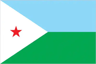 |
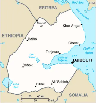
| Borderline map of Djibouti | Location map of Djibouti | Flag of Djibouti |
Google Maps and Detailed Facts of Djibouti (DJ). This page lets you explore Djibouti and its border countries (Country Location: Eastern Africa, bordering the Gulf of Aden and the Red Sea, between Eritrea and Somalia) through detailed Satellite imagery – fast and easy as never before Google Maps.
Find comprehensive information about this country’s diversity below: Google maps, geography, economy, science, people, culture, environment, government, and history – All in One Wiki page.
There is also a Street View and free Driving Directions at your service. Your Google Satellite Map Sightseeing in Djibouti, in Africa, starts here at Driving Directions and Maps.com.
Djibouti Google Maps & Satellite Maps
The map below shows Djibouti with its cities, towns, highways, main roads, streets, and Street Views. To find a location, use the form below, type any city or place, view a simple map, and click the “show map” button.
The Google map above shows Djibouti with its location: Africa (geographic coordinates: 11 30 N, 43 00 E) and the international borders of Djibouti; total: 528 km. Border countries (total: 3): Eritrea 125 km, Ethiopia 342 km, Somalia 61 km; furthermore, it’s inland counties boundaries.
Hint: Look at the Street view in Djibouti or Africa. All you have to do is drag and pull the little yellow man (named: Pegman) on the Google map above the desired location. After that, whenever it is available (more than 50 countries globally), blue stripes will appear to show the photos and details from Google’s regularly updated data image base. In case if you have signed in to your Google account currently, you may have a look at the satellite map of this country/area as well.
The map of Djibouti, Africa, is for informational use only. No representation is made or warrantied given any map or its content by Driving Directions and Maps site. The user assumes all risks of using this Djibouti Google map and facts/wiki.
About Djibouti in detail
Where is Djibouti?
Djibouti is looking on the map under the Coordinates 11 35 N 43 09 E otherwise in Africa, in Eastern Africa, bordering the Gulf of Aden and the Red Sea, between Eritrea and Somalia.
What is the capital city of Djibouti?
The capital city of Djibouti is Djibouti.
What is the time in Djibouti?
It is 8 hours ahead of Washington, D.C. during Standard Time; Djibouti’s timezone is UTC+3.
What is the Internet code for Djibouti?
The Top Level Domain (TLD) for Djibouti is: .dj
What is the size of Djibouti?
The territory of Djibouti is total: 23,200 sq km; land: 23,180 sq km, water: 20 sq km.
If we want to describe the size of the territory of Djibouti is somewhat smaller than New Jersey.
If we would like to walk around and discover Djibouti, we can cover a total distance: 528 km.
What is the water coverage of Djibouti?
We have already mentioned what percentage of Djibouti is covered by water (see below), and this includes 314 km coastline.
What is the climate like in Djibouti?
The climate of Djibouti is desert: torrid, dry.
Geographical data of Djibouti
Djibouti’s elevation; mean elevation: 430 m, elevation extremes; lowest point: Lac Assal -155 m, highest point: Moussa Ali 2,028 m.
The specific geographical details of Djibouti include coastal plain and plateau separated by central mountains.
Suppose we would like to describe the countries location from a different perspective. In that case, it is safe to say, and easy to read from a map, Djibouti is a strategic location near the world’s busiest shipping lanes and close to Arabian oilfields; terminus of rail traffic into Ethiopia; mostly wasteland; Lac Assal (Lake Assal) is the lowest point in Africa and the saltiest lake in the world.
Resources and land use of Djibouti
The country’s main mined products are potential geothermal power, gold, clay, granite, limestone, marble, salt, diatomite, gypsum, pumice, petroleum. The population partly uses the earlier highlighted land territory and partly left in its natural state: agricultural land: 73.4%; arable land 0.1%; permanent crops 0%; permanent pasture 73.3%; forest: 0.2%; other: 26.4% (2011 estimate).
Population data of Djibouti
The number of inhabitants of Djibouti is 846,687 (July 2016 estimate).
If we examine the proportion of the population distribution, it is safe to say that N/A.
If we look at the proportion of the urbanized and barely populated areas, these are the figures: urban population: 77.3% of the total population (2015).
Most of the population in Djibouti is concentrated in DJIBOUTI (capital) 529,000 (2015).
Ethnicity in Djibouti
According to ethnicity details, the ethnic groups are Somali 60%, Afar 35%, other 5% (includes French, Arab, Ethiopian, and Italian).
Spoken languages in Djibouti
Djibouti’s spoken languages are the following: French (official language), Arabic (official language), Somali, Afar.
What are the most important religions in Djibouti?
According to this, researchers examine the churches: Muslim 94%, Christian 6% during the general census.
Further population data of Djibouti
The proportion of gender and age tells a lot about the society as follows 0-14 years: 31.71% (male 134,604 / female 133,840) 15-24 years: 21.54% (male 85,805 / female 96,587) 25-54 years: 38.37% (male 134,945 / female 189,930) 55-64 years: 4.7% (male 18,257 / female 21,538) 65 years and over: 3.68% (male 13,992 / female 17,189) (2016 estimate). It also a significant factor in a society the population growth rate, which in the case of Djibouti is 2.18% (2016 estimate).
The population growth rate is based on two elements, the birth, and the death rate. In Djibouti the birth rate is 23.6 births / 1,000 population (2016 estimate), the death rate 7.6 deaths / 1,000 population (2016 estimate).
In this day and age in developed societies, the first child borns later compared to the previous centuries and decades, so childbearing is extended. In Djibouti, the average age of mothers at the first childbirth is N/A.
Although the children’s birth is postponed in the best-case scenario, the parents can still see their kids grow as life expectancy also extended. In the case of Djibouti, these figures are. With the introduction of modern medicine, vaccinations, and the proper hygienic conditions, the infant mortality rate is in a steep decline. The infant mortality statistics in Djibouti are the following: N/A. Relevant data is the budget of healthcare, which is in the case of this country is 10.6% of GDP (2014).
Economic data of Djibouti
Suppose we would like to describe a country. We also have to mention its economy; Djibouti’s economy is based on service activities connected with its strategic location as a deepwater port on the Red Sea. Three-fourths of Djibouti’s inhabitants live in the capital city; the remainder is mostly nomadic herders. Djibouti provides services as both a transit port for the region and an international transshipment and refueling center. Imports, exports, and re-exports represent 70% of port activity at Djibouti’s container terminal. Djibouti’s reliance on diesel-generated electricity and imported food and water leave average consumers vulnerable to global price shocks. However, in mid-2015, Djibouti passed new legislation to liberalize the energy sector.
GDP is a prominent figure, as all the relevant calculations and statistics are based on it. GDP in Djibouti is $1.894 billion (2015 estimate).
Another important indicator is the rate of GDP growth, which in Djibouti is 6.5% (2016 estimate) 6.5% (2015 estimate) 6% (2014 estimate).
These statistics affect the world economy; remember, in 2015, the Chinese real GDP growth rate was worse than expected; The world markets fall, and the Chinese stock exchange is temporally suspended.
A further major factor of a country’s economy, the GDP per capita. In Djibouti this is $3,400 (2016 estimate) $3,300 (2015 estimate) $3,100 (2014 estimate).
In the economy, the Trinity is in common places, such as agriculture, industry, and services.
What are the agricultural products Djibouti produces?
Djibouti’s main agricultural products are fruits, vegetables, goats, sheep, camels, animal hides.
Regarding the economy, the essential segments are construction, agricultural processing, shipping. The crucial and regularly mentioned GDP is based on construction, agricultural processing, shipping.
Drinking water source in Djibouti
It is essential to mention that – thanks to the development of the infrastructure -, the rate of potable water improved: urban: 97.4% of the population, rural: 64.7% of the people, total: 90% of the population. Unimproved: urban: 2.6% of the people, rural: 35.3% of the people, total: 10% of the population (2015 estimate).
The average number of childbirth in Djibouti
In Djibouti, the average delivery number is 2.35 children born / woman (2016 estimate).
Population, median age, migration, and citizenship in Djibouti
The population’s average age is 23.5 years; male: 21.8 years, female: 24.9 years (2016 estimate). The age of adulthood varies in every country of the world in Djibouti; it is 18 years of age, universal.
When we are experiencing an unprecedented scale of migration and globalization, it is an important factor in the number of new immigrants. In Djibouti is 5.9 migrant(s) / 1,000 population (2016 estimate). It is important to know how to apply for citizenship: citizenship by birth: no. Citizenship by descent only: the mother must be a citizen of Djibouti. Dual citizenship recognized: no—the residency requirement for naturalization: 10 years.
Is Djibouti a safe destination? Healthcare services and infectious diseases in Djibouti
Many of the travelers are looking into the healthcare services and infectious diseases of their destinations. In Djibouti, the hospital beds’ density is 1.4 beds / 1,000 population (2012).
According to the WHO rating regarding Djibouti’s contagious diseases, the degree of risk: high food or waterborne diseases: bacterial and protozoal diarrhea, hepatitis A, and typhoid fever vectorborne disease: dengue fever (2016).
However, HIV is not curable but maintainable. Let’s do not forget when the disease surfaced; it was a world threatening condition. Unfortunately, in some countries, it is still very high the number of infected patients and fatalities due to the disease.
In Djibouti, the number of HIV/AIDS deaths: N/A.
Regarding tourism obesity, not an important issue, but we have to mention health statistics, as it is the plague of the 20th and the 21st century. The rate of obese adults in Djibouti is 8.5% (2014).
What are the natural hazards in Djibouti? Is there any?
Djibouti’s most known natural risks are earthquakes, droughts; occasional cyclonic disturbances from the Indian Ocean bring heavy rains and flash flood volcanism: experiences limited volcanic activity; Ardoukoba (elevation 298 m) last erupted in 1978; Manda-Inakir, located along the Ethiopian border, is also historically active.
More interesting facts about Djibouti
A few words about the past, as every country and society, is connected to its history; The French Territory of the Afars and the Issas became Djibouti in 1977. Hassan Gouled APTIDON installed an authoritarian one-party state and proceeded to serve as president until 1999. Unrest among the Afar minority during the 1990s led to a civil war that ended in 2001 with a peace accord between Afar rebels and the Somali Issa-dominated government. In 1999, Djibouti’s first multiparty presidential election resulted in the election of Ismail Omar GUELLEH as president; he was re-elected to a second term in 2005 and extended his tenure in office via a constitutional amendment, which allowed him to serve a third term in 2011 and begin a fourth term in 2016. Djibouti occupies a strategic geographic location at the intersection of the Red Sea and the Gulf of Aden. It serves as an important shipping portal for goods entering and leaving the east African highlands and transshipments between Europe, the Middle East, and Asia. The government holds longstanding ties to France, which maintains a significant military presence in the country, and has strong ties with the US. Djibouti hosts several thousand members of the US armed services at US-run Camp Lemonnier.
In every nation’s memory, some cornerstones placed the country on the timeline of history. The date of declaration of independence of Djibouti: 27 June 1977 (from France).
The flag and other symbols of Djibouti
The colors, symbols, and animals on the flag usually have a historical background or an important milestone or memory of the nation.
This case is not an exception either; two equal horizontal bands of light blue (top) and light green with a white isosceles triangle based on the hoist side bearing a red five-pointed star in the center; blue stands for sea and sky and the Issa Somali people; green symbolizes earth and the Afar people; white represents peace; the red star recalls the struggle for independence and stands for unity.
Apart from the flag, the symbol of national unity is the national anthem. The anthem’s primary purpose is to share the nation’s core values, endeavors, and patriotic feelings.
Djibouti’s national symbols: red star; national colors: light blue, green, white, red.
Constitution of Djibouti
The existence of the nation is based on the constitution. Some constitutions knew worldwide, like the U.S. Constitution that was accepted on the 17th of September 1787, in Philadelphia, the United States of America’s Constitution.
It is not related to the declaration of independence that was stolen by Nicolas Cage in the movie National Treasure 🙂
What is the legal system of Djibouti?
Most of the time, the legal system of a country is the focus of lawyers. It is a common fact that there are two main approaches in the world, “the law in books” and “the law in action.”
In the Anglo-Saxon world, the practice is the “law in action,” while in the rest of the world, the law is based on Roman law, the “law in books.”
Djibouti’s legal system is a mixed legal system based primarily on the French civil code (as it existed in 1997), Islamic religious law (in matters of family law and successions), and customary law.
It was Aristotle who founded the Theory of 3 separations of powers. In his view, these are the council of public affairs, the magistrates, and the justice system. The age of enlightenment was the time when terminologies have defined the way we still use them. In most democratic countries, the three authorities separated from each other. In dictatorships, the rules usually interweaved in one hand.
About the legislative branch of Djibouti, we can highlight the following structures unicameral National Assembly or Assemblee Nationale, formerly the Chamber of Deputies (65 seats; 52 members directly elected in multi-seat constituencies by simple majority vote and 13 directly elected in multi-seat constituencies by proportional representation vote; members serve 5-year terms).
About the unemployment rate, labor force, and poverty line in Djibouti
One of the major problems of the 21st-century economy is unemployment. Governments are struggling to maintain a low level of the unemployment rate. Still, as a result of automation, the cheap 3rd world labor, and the outsourcing of workflow, these attempts fail. In Djibouti, the labor force is 294,600 (2012). Please bear in mind that the population in Djibouti is total: 47.2 deaths / 1,000 live births; male: 54.1 deaths / 1,000 live births, female: 40.1 deaths / 1,000 live births (2016 estimate) – as we already mentioned above.
The rate of unemployment in Djibouti is 60% (2014 estimate).
Widely known that the gap between the rich and poor is widening on an enormous scale.
According to the 2017 shocking Oxfam report, the most affluent eight people’s fortune is equal to the wealth of the poorest half of the world’s population.
In Djibouti, the households’ income and consumption compared to the entire population: lowest 10%: 2.4% highest 10%: 30.9% (2002).
Another widely used indicator is the so-called GINI index, which measures the inequalities of statistical dispersion, but is mainly used for measuring the sharing of income and fortune.
The GINI index was named after its founder Corrado Gini, an Italian economist. Gini index has grades between 0-1, but often it is used on a percentage basis. It is 0 if the examined criteria territorial distribution is equal. It is one of the criteria concentrated on the territory. In Djibouti, the GINI index is .40,9 (2002).
The states usually set up a poverty line, which is more or less, is a subjective measure. It varies by country; its base is often the minimum pension, the incomes of the most deficient 20 percent, the X percent of income per capita Etc.
In Djibouti, the poverty line people are the lowest 10%: 2.4% highest 10%: 30.9% (2002).
About the budget and central governments debt of Djibouti
The available budget mainly defines the state’s economy. Djibouti’s budget is; revenues: $685.7 million, expenditures: $885.9 million (2016 estimate). Taxes and other revenues are 36.2% of GDP (2016 estimate).
The budget deficit (Budget surplus (+) or deficit (-)) is N/A.
The fiscal year in Djibouti is the calendar year.
In the country’s economy, we have to consider the public debt. Public debt is the consolidated sum of the state’s local, federal, and central government debt.
Inflation rate and prime lending rate in Djibouti
A few further interesting and relevant economic data are the following; Inflation rate: 3% (2016 estimate), 2.7% (2015 estimate), and the rate of the Commercial bank prime lending rate: 11.7% (31 December 2016 estimate).
Export/import partners and data of Djibouti
Djibouti, with the export of products, industrial tools, and other services, generates revenue. The export value in Djibouti is: $146.1 million (2016 estimate), $141.9 million (2015 estimate). The total revenue of these activities: reexports, hides and skins, coffee (in transit), scrap metal.
Djibouti’s most important export partners are Somalia, 79.8%, the United States 5.4%, Yemen 4.6%, the United Arab Emirates 4% (2015).
The most important imported products are foods, beverages, transport equipment, chemicals, petroleum products, clothing, and the countries from where the import is coming: China 42.1%, Saudi Arabia 14.3%, Indonesia 5.9%, India 4.4% (2015).
Renewable energies used in Djibouti
To suppress the pollution of the environment, renewable energies have to replace the fossil energy. The more the proportion of renewable energies in a country means more effort against pollution. Djibouti, the indicator of how much of the country’s produced energy is coming from the hydroelectric source, is 0% of total installed capacity (2012 estimate).
To indicate how much another renewable energy produced is 1.1% of total installed capacity (2012 estimate).
Telecommunication data of Djibouti, calling code
To maintain the economy, the development of a reliable and modern telecommunications infrastructure is crucial. We can say the following about Djibouti; telephone facilities in the city of Djibouti are adequate, as are the microwave radio relay connections to outlying areas of the country. Domestic: Djibouti Telecom is the sole provider of telecommunications services and utilizes mostly a microwave radio relay network; fiber-optic cable is installed in the capital; rural areas connected via wireless local loop radio systems; mobile cellular coverage. International: country code – 253; landing point for the SEA-ME-WE-3 and EASSy fiber-optic submarine cable systems providing links to Asia, the Middle East, Europe, and North America; satellite earth stations – 2 (1 Intelsat – the Indian Ocean and 1 Arabsat); Medarabtel regi (2015).
Transport infrastructure in Djibouti
In the 21st century, we often say that the world has become small and there are no distances anymore. With widespread air travel when (sometimes) there are no visa restrictions, it is easy to reach other countries, but if the distance is not too long, we can also use railway or water transportation.
The number of airports in Djibouti: 13 (2013), and the number of heliports: N/A.
The total length of the roadways in Djibouti: total: 3,065 km, paved: 1,379 km, unpaved: 1,686 km (2000).
The total length of the waterways in Djibouti: N/A.
Are you traveling to Djibouti?
If you plan to travel by plane to Djibouti, try our air ticket comparison site, where you can choose from hundreds of carriers and offers. Our application is scanning the market and shows you the best and the cheapest deals without any extra charge or commission.
Are you looking for a hotel, apartment another kind of accommodation in Djibouti, Africa? We are here to help you to find your accommodation from budget to luxury. Our search engine is scanning, regularly updating data from hundreds of accommodation websites and more than a million offers. You can quickly and easily find your hotel stay anywhere in the world, without any extra charge or commission.
Facts & data about Djibouti
Name of the country: conventional long way: the Republic of Djibouti, traditional short form: Djibouti, local long form: Republique de Djibouti/Jumhuriyat Jibuti, local short state: Djibouti/Jibuti, former: French Territory of the Afars and Issas, French Somaliland, etymology: the country name derives from the capital city of Djibouti.
| Abbreviation: Djibouti | Geographic coordinates: 11 30 N, 43 00 E |
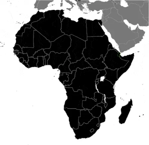
Country Location: Africa |
| Capital of Djibouti: Djibouti | GPS of the Capital: 11 35 N 43 09 E |
Position: Eastern Africa, bordering the Gulf of Aden and the Red Sea, between Eritrea and Somalia |
| Land area: total: 23,200 sq km; land: 23,180 sq km, water: 20 sq km | Terrain: coastal plain and plateau separated by central mountains |
Area comparative: somewhat smaller than New Jersey |
| Population: 846,687 (July 2016 estimate) | Population grow rate: 2.18% (2016 estimate) | Sex ratio: at birth: 1.03 male(s) / female, 0-14 years: 1.01 male(s) / female, 15-24 years: 0.89 male(s) / female, 25-54 years: 0.71 male(s) / female, 55-64 years: 0.85 male(s) / female, 65 years and over: 0.82 male(s) / female, total population: 0.84 male(s) / female (2016 estimate) |
| Exports: $146.1 million (2016 estimate), $141.9 million (2015 estimate) | Imports: $992 million (2016 estimate), $1.038 billion (2015 estimate) | Import partners: China 42.1%, Saudi Arabia 14.3%, Indonesia 5.9%, India 4.4% (2015) |
| Urbanization: urban population: 77.3% of the total population (2015) | Major urban area(s): DJIBOUTI (capital) 529,000 (2015) | Median age: total: 23.5 years; male: 21.8 years, female: 24.9 years (2016 estimate) |
| Internet users: total: 99,000. Percent of the population: 11.9% (July 2015 estimate) | Telephones (fixed-lines): total subscriptions: 23,000. Subscriptions per 100 inhabitants: 3 (July 2015 estimate) | Telephones (mobile, cellular): total: 312,000. Subscriptions per 100 inhabitants: 38 (July 2015 estimate) |
| Unemployment rate: 60% (2014 estimate) | Nationality: Djiboutian(s) adjective: Djiboutian | National holidays: Independence Day, 27 June (1977) |
| Life expectancy at birth: total population: 63.2 years. Male: 60.7 years, female: 65.8 years (2016 estimate) | Total fertility rate: 2.35 children born / woman (2016 estimate) | Birthrate: 23.6 births / 1,000 population (2016 estimate) |
| Literacy: N/A | Legal system: mixed legal system based primarily on the French civil code (as it existed in 1997), Islamic religious law (in matters of family law and successions), and customary law | Suffrage: 18 years of age, universal |
| Industries: construction, agricultural processing, shipping | Industrial production growth rate: 4.7% (2016 estimate) | GDP real growth rate: 6.5% (2016 estimate) 6.5% (2015 estimate) 6% (2014 estimate) |
Do you like this Djibouti Google maps™ & country information page?
Please do us a favor: Share or like this page using the icons at the top of the page. We also do encourage you to visit our Facebook page for more travel and country related information.
Many thanks for visiting and sharing this map & country information site!