
 |
 |
 |
| Borderline map of Cote d’Ivoire | Location map of Cote d’Ivoire | Flag of Cote d’Ivoire |
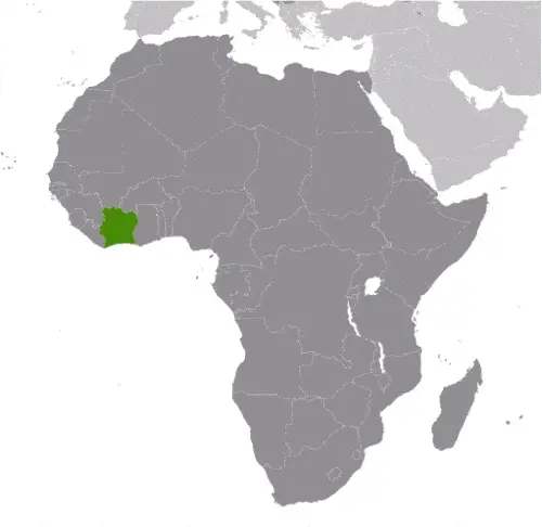
Google Maps and Detailed Facts of Cote d’Ivoire (CI). This page lets you explore Cote d’Ivoire and its border countries (Country Location: Western Africa, bordering the North Atlantic Ocean, between Ghana and Liberia) through detailed Satellite imagery – fast and easy as never before Google Maps.
Find comprehensive information about this country’s diversity below: Google maps, geography, economy, science, people, culture, environment, government, and history – All in One Wiki page.
There is also a Street View and free Driving Directions at your service. Your Google Satellite Map Sightseeing in Cote d’Ivoire, in Africa, starts here at Driving Directions and Maps.com.
Cote d’Ivoire Google Maps & Satellite Maps
The map below shows Cote d’Ivoire with its cities, towns, highways, main roads, streets, and Street Views. To find a location, use the form below, type any city or place, view a simple map, and click the “show map” button.
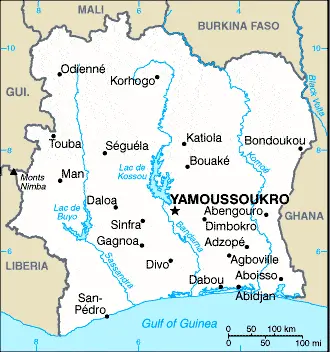
The Google map above shows Cote d’Ivoire with its location: Africa (geographic coordinates: 8 00 N, 5 00 W) and the international borders of Cote d’Ivoire; total: 3,458 km. Border countries (total: 5): Burkina Faso 545 km, Ghana 720 km, Guinea 816 km, Liberia 778 km, Mali 599 km; furthermore, it’s inland counties boundaries.
Hint: Look at the Street view in Cote d’Ivoire, or Africa. All you have to do is drag and pull the little yellow man (named: Pegman) on the Google map above the desired location. After that, whenever it is available (more than 50 countries globally), blue stripes will appear to show the photos and details from Google’s regularly updated data image base. In case if you have signed in to your Google account currently, you may have a look at the satellite map of this country/area as well.
The map of Cote d’Ivoire, Africa, is for informational use only. No representation is made or warrantied given any map or its content by Driving Directions and Maps site. The user assumes all risks of using this Cote d’Ivoire Google map and facts/wiki.
About Cote d’Ivoire in detail
Where is Cote d’Ivoire?
Cote d’Ivoire is looking on the map under the Coordinates 6 49 N 5 16 W otherwise in Africa, in Western Africa, bordering the North Atlantic Ocean, between Ghana and Liberia.
What is the capital city of Cote d’Ivoire?
The capital city of Cote d’Ivoire is: Yamoussoukro.
What is the time in Yamoussoukro?
It is 5 hours ahead of Washington, D.C. during Standard Time; Yamoussoukro’s timezone is UTC 0.
What is the Internet code for Cote d’Ivoire?
The Top Level Domain (TLD) for Cote d’Ivoire is: .ci
What is the size of Cote d’Ivoire?
The territory of Cote d’Ivoire is a total: 322,463 sq km; land: 318,003 sq km, water: 4,460 sq km.
If we want to describe the size of Cote d’Ivoire’s territory, it is slightly larger than New Mexico.
If we would like to walk around and discover Cote d’Ivoire, we can cover a total distance: 3,458 km.
What is the water coverage of Cote d’Ivoire?
We have already mentioned what percentage of Cote d’Ivoire is covered by water (see below), and this includes 515 km coastline.
What is the climate like in Cote d’Ivoire?
The climate of Cote d’Ivoire is tropical along the coast, semiarid in the far north: three seasons – warm and dry (November to March), hot and dry (March to May), hot and wet (June to October).
Geographical data of Cote d’Ivoire
The elevation of Cote d’Ivoire; mean elevation: 250 m, elevation extremes; lowest point: Gulf of Guinea 0 m, highest point: Monts Nimba 1,752 m.
The specific geographical details of Cote d’Ivoire include mostly flat to undulating plains; mountains in the northwest.
Suppose we would like to describe the countries location from a different perspective. In that case, it is safe to say, and easy to read from a map, Cote d’Ivoire is most of the inhabitants live along the sandy coastal region; apart from the capital area, the forested interior is sparsely populated.
Resources and land use of Cote d’Ivoire
The country’s main mined products are petroleum, natural gas, diamonds, manganese, iron ore, cobalt, bauxite, copper, gold, nickel, tantalum, silica sand, clay, cocoa beans, coffee, palm oil, hydropower. The population partly uses the earlier highlighted land territory and partly left in its natural state: agricultural land: 64.8%; arable land 9.1%; permanent crops 14.2%; permanent pasture 41.5%; forest: 32.7%; other: 2.5% (2011 estimate).
Population data of Cote d’Ivoire
The number of inhabitants of Cote d’Ivoire is 23,740,424 (July 2016 estimate).
If we examine the proportion of the population distribution, it is safe to say that N/A.
If we look at the proportion of the urbanized and barely populated areas, these are the figures: urban population: 54.2% of the total population (2015).
Most of the population in Cote d’Ivoire is concentrated in YAMOUSSOUKRO (capital) 259,000 (2014); ABIDJAN (seat of government) 4.86 million; Bouake 762,000 (2015).
Ethnicity in Cote d’Ivoire
According to ethnicity details, the ethnic groups are Akan 32.1%, Voltaique or Gur 15%, Northern Mande 12.4%, Krou 9.8%, Southern Mande 9%, other 21.2% (includes European and Lebanese descent), unspecified 0.5% (2011-12 estimate).
Spoken languages in Cote d’Ivoire
The spoken languages in Cote d’Ivoire are French (official language), 60 native dialects of which Dioula is the most widely spoken.
What are the most important religions in Cote d’Ivoire?
During the general census, researchers examine the churches, according to this: Muslim 40.2%, Catholic 19.4%, Evangelical 19.3%, Methodist 2.5%, other Christian 4.5%, animist or no religion 12.8%, other religion/unspecified 1.4% (2011-12 estimate). Note: the majority of foreign migrant workers are Muslim (72%) and Christian (18%) (2014 estimate).
Further population data of Cote d’Ivoire
The proportion of gender and age tells a lot about the society as follows 0-14 years: 37.45% (male 4,483,215 / female 4,407,595) 15-24 years: 20.93% (male 2,504,188 / female 2,463,970) 25-54 years: 34.05% (male 4,133,975 / female 3,950,734) 55-64 years: 4.15% (male 493,722 / female 491,230) 65 years and over: 3.42% (male 389,551 / female 422,244) (2016 estimate). It also a significant factor in a society the population growth rate, which in the case of Cote d’Ivoire is 1.88% (2016 estimate).
The population growth rate is based on two elements, the birth, and the death rate. In Cote d’Ivoire the birth rate is 28.2 births / 1,000 population (2016 estimate), the death rate 9.5 deaths / 1,000 population (2016 estimate).
In this day and age in developed societies, the first child borns later compared to the previous centuries and decades, so childbearing is extended. In Cote d’Ivoire, the average age of mothers at the first childbirth is N/A.
Although the children’s birth is postponed in the best-case scenario, the parents can still see their kids grow as life expectancy also extended. In the case of Cote d’Ivoire, these figures are. With the introduction of modern medicine, vaccinations, and the proper hygienic conditions, the infant mortality rate is in a steep decline. The infant mortality statistics in Cote d’Ivoire are the following: N/A. Relevant data is the budget of healthcare, which is 5.7% of GDP (2014).
Economic data of Cote d’Ivoire
Suppose we would like to describe a country. We also have to mention its economy; Cote d’Ivoire is heavily dependent on agriculture and related activities, which engage roughly two-thirds of the population. Cote d’Ivoire is the world’s largest producer and exporter of cocoa beans and a significant producer and exporter of coffee. Following the end of more than a decade of civil conflict in 2011, Cote d’Ivoire has experienced a boom in foreign investment and economic growth.
GDP is a prominent figure, as all the relevant calculations and statistics are based on it. GDP in Cote d’Ivoire is $34.65 billion (2015 estimate).
Another important indicator is the rate of GDP growth, which in Cote d’Ivoire is 8% (2016 estimate), 8.5% (2015 estimate) 7.9% (2014 estimate).
These statistics affect the world economy; remember, in 2015, the Chinese real GDP growth rate was worse than expected; The world markets fall, and the Chinese stock exchange was temporally suspended.
A further major factor of a country’s economy, the GDP per capita. In Cote d’Ivoire this is $3,600 (2016 estimate) $3,400 (2015 estimate) $3,200 (2014 estimate).
In the economy, the Trinity is in common places, such as agriculture, industry, and services.
What are the agricultural products Cote d’Ivoire produces?
The main agricultural products of Cote d’Ivoire are coffee, cocoa beans, bananas, palm kernels, corn, rice, cassava (manioc, tapioca), sweet potatoes, sugar, cotton, rubber, timber.
The important segments are foodstuffs, beverages, wood products, oil refining, gold mining, truck and bus assembly, textiles, fertilizer, building materials, and electricity.
Drinking water source in Cote d’Ivoire
It is essential to mention that – thanks to the development of the infrastructure -, the rate of potable water improved: urban: 93.1% of the population, rural: 68.8% of the people, total: 81.9% of the population. Unimproved: urban: 6.9% of the people, rural: 31.2% of the people, 18.1% of the population (2015 estimate).
The average number of childbirth in Cote d’Ivoire
In Cote d’Ivoire, the average delivery number is 3.46 children born / woman (2016 estimate).
Population, median age, migration, and citizenship in Cote d’Ivoire
The population’s average age is 20.7 years; male: 20.8 years, female: 20.6 years (2016 estimate). The age of adulthood varies in every country of the world in Cote d’Ivoire; it is 18 years of age, universal.
When we are experiencing an unprecedented scale of migration and globalization, it is an important factor in the number of new immigrants. In Cote d’Ivoire is 0 migrant(s) / 1,000 population (2016 estimate). It is important to know how to apply for citizenship: citizenship by birth: no. Citizenship by descent only: at least one parent must be a citizen of Cote d’Ivoire. Dual citizenship recognized: no—residency requirement for naturalization: 5 years.
Is Cote d’Ivoire a safe destination? Healthcare services and infectious diseases in Cote d’Ivoire
Many of the travelers are looking into the healthcare services and infectious diseases of their destinations. In Cote d’Ivoire, the hospital beds’ density is 0.4 beds / 1,000 population (2006).
According to the WHO rating regarding contagious diseases in Cote d’Ivoire, the degree of risk: very high food or waterborne diseases: bacterial diarrhea, hepatitis A, and typhoid fever vectorborne diseases: malaria, dengue fever, and yellow fever water contact disease: schistosomiasis animal, contact disease: rabies, respiratory disease: meningococcal meningitis (2016).
However, HIV is not curable but maintainable. Let’s do not forget when the disease surfaced; it was a world threatening condition. Unfortunately, in some countries, it is still very high the number of infected patients and fatalities due to the disease.
In Cote d’Ivoire, the number of HIV/AIDS deaths: N/A.
Regarding tourism obesity, not an important issue, but we have to mention health statistics, as it is the plague of the 20th and the 21st century. The rate of obese adults in Cote d’Ivoire is 8% (2014).
What are the natural hazards in Cote d’Ivoire? Is there any?
The most known natural risk in Cote d’Ivoire is coast has heavy surf and no natural harbors; during the rainy season, torrential flooding is possible.
More interesting facts about Cote d’Ivoire
A few words about the past, as every country and society, is connected to its history; Close ties to France following independence in 1960, the development of cocoa production for export, and foreign investment all made Cote d’Ivoire one of the most prosperous of the West African states. Still, they did not protect it from political turmoil. In December 1999, a military coup – the first ever in Cote d’Ivoire’s history – overthrew the government. Junta leader Robert GUEI blatantly rigged elections held in late 2000 and declared himself the winner. Popular protest forced him to step aside, and an election brought Laurent GBAGBO into power. Ivoirian dissidents and disaffected military members launched a failed coup attempt in September 2002 that developed into a rebellion and then a civil war. In 2003, a cease-fire resulted in the country being divided, with the rebels holding the north, the government the south, and peacekeeping forces a buffer zone.
In March 2007, President GBAGBO and former New Forces rebel leader Guillaume SORO signed an agreement in which SORO joined GBAGBO’s government as prime minister. The two agreed to reunite the country, dismantling the buffer zone, integrating rebel forces into the national armed forces, and holding elections. Difficulties in preparing electoral registers delayed balloting until 2010. In November 2010, Alassane Dramane OUATTARA won the presidential election over GBAGBO, but GBAGBO refused to hand over power, resulting in a five-month resumption of violent conflict. In April 2011, after widespread fighting, GBAGBO was formally forced from office by armed OUATTARA supporters with UN and French forces’ help. The UN peacekeeping mission is drawing down and is scheduled to depart in June 2017. OUATTARA is focused on rebuilding the country’s economy and infrastructure while rebuilding the security forces. GBAGBO is in The Hague on trial for crimes against humanity.
In every nation’s memory, some cornerstones placed the country on the timeline of history. The date of declaration of independence of Cote d’Ivoire: 7 August 1960 (from France).
The flag and other symbols of Cote d’Ivoire
The colors, symbols, and animals on the flag usually have a historical background or an important milestone or memory of the nation.
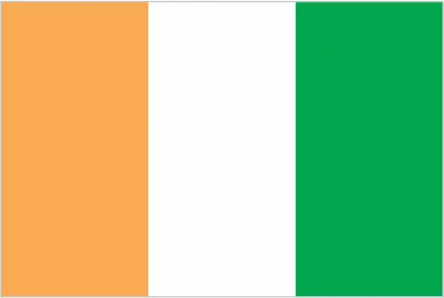
This case is not an exception either; three equal vertical bands of orange (hoist side), white, and green; orange symbolizes the land (savannah) of the north and fertility, white stands for peace and unity, green represents the forests of the south and the hope for a bright future. Note: similar to the flag of Ireland, which is longer and has the colors reversed – green (hoist side), white, and orange; also identical to the flag of Italy, which is green (hoist side), white, and red; the design was based on the flag of France.
Apart from the flag, the symbol of national unity is the national anthem. The anthem’s primary purpose is to share the nation’s core values, endeavors, and patriotic feelings.
National symbols of Cote d’Ivoire: elephant; national colors: orange, white, green.
Constitution of Cote d’Ivoire
The existence of the nation is based on the constitution. Some constitutions knew worldwide, like the U.S. Constitution that was accepted on the 17th of September 1787, in Philadelphia, the United States of America’s Constitution.
It is not related to the declaration of independence that was stolen by Nicolas Cage in the movie National Treasure 🙂
What is the legal system of Cote d’Ivoire?
Most of the time, the legal system of a country is the focus of lawyers. It is a common fact that there are two main approaches in the world, “the law in books” and “the law in action.”
In the Anglo-Saxon world, the practice is the “law in action,” while in the rest of the world, the law is based on Roman law, the “law in books.”
The legal system of Cote d’Ivoire is a civil law system based on the French civil code; judicial review of legislation held in the Constitutional Chamber of the Supreme Court.
It was Aristotle who founded the Theory of 3 separations of powers. In his view, these are the council of public affairs, the magistrates, and the justice system. The age of enlightenment was the time when terminologies have defined the way we still use them. In most democratic countries, the three authorities separated from each other. In dictatorships, the rules usually interweaved in one hand.
About the legislative branch of Cote d’Ivoire, we can highlight the following structures unicameral Parliament consists of the National Assembly (255 seats; members directly elected in single- and multi-seat constituencies by simple majority vote to serve 5-year terms); note – the new constitution of November 2016 calls for a bicameral legislature with the addition of a Senate.
About the unemployment rate, labor force, and poverty line in Cote d’Ivoire
One of the major problems of the 21st-century economy is unemployment. Governments are struggling to maintain a low level of the unemployment rate. Still, as a result of automation, the cheap 3rd world labor, and the outsourcing of workflow, these attempts fail. In Cote d’Ivoire, the labor force is 8.543 million (2016 estimate). Please bear in mind that the population in Cote d’Ivoire is total: 57.2 deaths / 1,000 live births; male: 63.1 deaths / 1,000 live births, female: 51.1 deaths / 1,000 live births (2016 estimate) – as we already mentioned above.
The rate of unemployment in Cote d’Ivoire is N/A %.
Widely known that the gap between the rich and poor is widening on an enormous scale.
According to the 2017 shocking Oxfam report, the most affluent eight people’s fortune is equal to the wealth of the poorest half of the world’s population.
In Cote d’Ivoire, the households’ income and consumption compared to the entire population: lowest 10%: 2.2% highest 10%: 31.8% (2008).
Another widely used indicator is the so-called GINI index, which measures the inequalities of statistical dispersion, but is mainly used for measuring the sharing of income and fortune.
The GINI index was named after its founder Corrado Gini, an Italian economist. Gini index has grades between 0-1, but often it is used on a percentage basis. It is 0 if the examined criteria territorial distribution is equal. It is one of the criteria concentrated on the territory. In Cote d’Ivoire, the GINI index is .41,5 (2008).
The states usually set up a poverty line, which is more or less, is a subjective measure. It varies by country; its base is often the minimum pension, the incomes of the most deficient 20 percent, the X percent of income per capita Etc.
In Cote d’Ivoire, the poverty line people are the lowest 10%: 2.2% highest 10%: 31.8% (2008).
About the budget and central governments debt of Cote d’Ivoire
The available budget mainly defines the state’s economy. Cote d’Ivoire’s budget is; revenues: $6.839 billion, expenditures: $8.17 billion (2016 estimate). Taxes and other revenues are 19.7% of GDP (2016 estimate).
The budget deficit (Budget surplus (+) or deficit (-)) is N/A.
The fiscal year in Cote d’Ivoire is the calendar year.
In the country’s economy, we have to consider the public debt. Public debt is the consolidated sum of the state’s local, federal, and central government debt.
Inflation rate and prime lending rate in Cote d’Ivoire
A few further interesting and relevant economic data are the following; Inflation rate: 1.2% (2016 estimate), 1.3% (2015 estimate), and the rate of the Commercial bank prime lending rate: 2.5% (31 December 2016 estimate).
Export/import partners and data of Cote d’Ivoire
Cote d’Ivoire, with the export of products, industrial tools, and other services, generates revenue. The export value in Cote d’Ivoire is $11.73 billion (2016 estimate), $11.98 billion (2015 estimate). The total revenue of these activities: cocoa, coffee, timber, petroleum, cotton, bananas, pineapples, palm oil, fish.
The most important export partners of Cote d’Ivoire are the United States 8.5%, Netherlands 6.2%, France 5.6%, Germany 5.6%, Nigeria 5.5%, Burkina Faso 5.5%, Belgium 5.3%, India 4.6%, Ghana 4.4%, Switzerland 4.1% (2015).
The most important imported products are fuel, capital equipment, foodstuffs, and the countries from where the import is coming: Nigeria 21.9%, China 14.4%, France 11.4%, the Bahamas 5% (2015).
Renewable energies used in Cote d’Ivoire
To suppress the pollution of the environment, renewable energies have to replace the fossil energy. The more the proportion of renewable energies in a country means more effort against pollution. Cote d’Ivoire indicates how much of the country’s produced energy comes from the hydroelectric source, 39.7% of total installed capacity (2012 estimate).
To indicate how much another renewable energy produced is 0% of total installed capacity (2012 estimate).
Telecommunication data of Cote d’Ivoire, calling code
To maintain the economy, the development of a reliable and modern telecommunications infrastructure is crucial. We can say the following about Cote d’Ivoire; well-developed by African standards; telecommunications sector privatized in the late 1990s, and operational fixed-lines have increased since that time with two fixed-line providers operating over open-wire lines, microwave radio relay, and fiber-optics; 90%. Domestic: with multiple mobile-cellular service providers competing in the market, usage has increased sharply to over 105 per 100 persons. International: country code – 225; landing point for the SAT-3/WASC fiber-optic submarine cable that provides connectivity to Europe and Asia; satellite earth stations – 2 Intelsat (1 the Atlantic Ocean and 1 Indian Ocean) (2011).
Transport infrastructure in Cote d’Ivoire
In the 21st century, we often say that the world has become small and there are no distances anymore. With widespread air travel when (sometimes) there are no visa restrictions, it is easy to reach other countries, but if the distance is not too long, we can also use railway or water transportation.
The number of airports in Cote d’Ivoire: 27 (2013), and the number of heliports: 1 (2013).
The total length of the roadways in Cote d’Ivoire: total: 81,996 km, paved: 6,502 km, unpaved: 75,494 km, note: includes intercity and urban roads; another 20,000 km of dirt roads are in poor condition, and 150,000 km of dirt roads are impassable (2007).
The waterways’ total length in Cote d’Ivoire: 980 km (navigable rivers, canals, and numerous coastal lagoons) (2011).
Are you traveling to Cote d’Ivoire?
If you plan to travel by plane to Cote d’Ivoire, try our air ticket comparison site, where you can choose from hundreds of carriers and offers. Our application is scanning the market and shows you the best and the cheapest deals without any extra charge or commission.
Are you looking for a hotel, apartment another kind of accommodation in Cote d’Ivoire, Africa? We are here to help you to find your accommodation from budget to luxury. Our search engine is scanning, regularly updating data from hundreds of accommodation websites and more than a million offers. You can quickly and easily find your hotel stay anywhere in the world, without any extra charge or commission.
Facts & data about Cote d’Ivoire
Name of the country: conventional long way: the Republic of Cote d’Ivoire, traditional short form: Cote d’Ivoire, local long form: Republique de Cote d’Ivoire, local short state: Cote d’Ivoire. Note: pronounced coat-div-whar, former: Ivory Coast, etymology: name reflects the intense ivory trade in the region from the 15th to 17th centuries.
| Abbreviation: Cote d’Ivoire | Geographic coordinates: 8 00 N, 5 00 W |
Country Location: Africa |
| Capital of Cote d’Ivoire: Yamoussoukro | GPS of the Capital: 6 49 N 5 16 W |
Position: Western Africa, bordering the North Atlantic Ocean, between Ghana and Liberia |
| Land area: total: 322,463 sq km; land: 318,003 sq km, water: 4,460 sq km | Terrain: mostly flat to undulating plains; mountains in northwest |
Area comparative: slightly larger than New Mexico |
| Population: 23,740,424 (July 2016 estimate) | Population grow rate: 1.88% (2016 estimate) | Sex ratio: at birth: 1.03 male(s) / female, 0-14 years: 1.02 male(s) / female, 15-24 years: 1.02 male(s) / female, 25-54 years: 1.05 male(s) / female, 55-64 years: 1.01 male(s) / female, 65 years and over: 0.93 male(s) / female, total population: 1.02 male(s) / female (2016 estimate) |
| Exports: $11.73 billion (2016 estimate), $11.98 billion (2015 estimate) | Imports: $8.966 billion (2016 estimate), $8.609 billion (2015 estimate) | Import partners: Nigeria 21.9%, China 14.4%, France 11.4%, Bahamas, The 5% (2015) |
| Urbanization: urban population: 54.2% of the total population (2015) | Major urban area(s): YAMOUSSOUKRO (capital) 259,000 (2014); ABIDJAN (seat of government) 4.86 million; Bouake 762,000 (2015) | Median age: total: 20.7 years; male: 20.8 years, female: 20.6 years (2016 estimate) |
| Internet users: total: 4.892 million. Percent of the population: 21% (July 2015 estimate) | Telephones (fixed-lines): total subscriptions: 277,248. Subscriptions per 100 inhabitants: 1 (July 2015 estimate) | Telephones (mobile, cellular): total: 25.408 million. Subscriptions per 100 inhabitants: 109 (July 2015 estimate) |
| Unemployment rate: N/A % | Nationality: Ivoirian(s) adjective: Ivoirian | National holidays: Independence Day, 7 August (1960) |
| Life expectancy at birth: total population: 58.7 years. Male: 57.5 years, female: 59.9 years (2016 estimate) | Total fertility rate: 3.46 children born / woman (2016 estimate) | Birthrate: 28.2 births / 1,000 population (2016 estimate) |
| Literacy: age 15 and over can read and write. Total population: 43.1%; male: 53.1%, female: 32.5% (2015 estimate) | Legal system: civil law system based on the French civil code; judicial review of legislation held in the Constitutional Chamber of the Supreme Court | Suffrage: 18 years of age, universal |
| Industries: foodstuffs, beverages; wood products, oil refining, gold mining, truck and bus assembly, textiles, fertilizer, building materials, electricity | Industrial production growth rate: 8.5% (2016 estimate) | GDP real growth rate: 8% (2016 estimate) 8.5% (2015 estimate) 7.9% (2014 estimate) |
Do you like this Cote d’Ivoire Google maps™ & country information page?
Please do us a favor: Share or like this page using the icons at the top of the page. We also do encourage you to visit our Facebook page for more travel and country related information.
Thank you for visiting & supporting us!