
 |
 |
 |
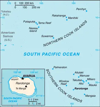
| Borderline map of Cook Islands | Location map of Cook Islands | Flag of Cook Islands |
Google Maps and Detailed Facts of Cook Islands (CK). This page lets you explore the Cook Islands and its border countries (Country Location: Oceania, group of islands in the South Pacific Ocean, about halfway between Hawaii and New Zealand) through detailed Satellite imagery – fast and easy as never before Google Maps.
Find comprehensive information about this country’s diversity below: Google maps, geography, economy, science, people, culture, environment, government, and history – All in One Wiki page.
There is also a Street View and free Driving Directions at your service. In Oceania, your Google Satellite Map Sightseeing in the Cook Islands starts here at Driving Directions and Maps.com.
Cook Islands Google Maps & Satellite Maps
The map below shows the Cook Islands with its cities, towns, highways, main roads, streets, and Street Views. To find a location, use the form below, type any city or place, view a simple map, and click the “show map” button.
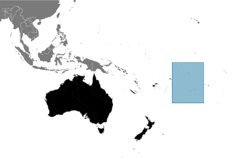
The Google map above shows the Cook Islands with its location: Oceania (geographic coordinates: 21 14 S, 159 46 W) and the international borders of Cook Islands; 0 km; furthermore, it’s inland counties boundaries.
Hint: Look at the Street view in the Cook Islands or Oceania. All you have to do is drag and pull the little yellow man (named: Pegman) on the Google map above the desired location. After that, whenever it is available (more than 50 countries globally), blue stripes will appear to show the photos and details from Google’s regularly updated data image base. In case if you have signed in to your Google account currently, you may have a look at the satellite map of this country/area as well.
The map of Cook Islands, Oceania, is for informational use only. No representation is made or warrantied given any map or its content by Driving Directions and Maps site. The user assumes all risks of using this Cook Islands Google map and facts/wiki.
About the Cook Islands in detail
Where is the Cook Islands?
The Cook Islands, in case, if you are looking on the map under the Coordinates 21 12 S 159 46 W otherwise in Oceania, in Oceania, group of islands in the South Pacific Ocean, about halfway between Hawaii and New Zealand.
What is the capital city of Cook Islands?
The capital city of Cook Islands is Avarua.
What is the time in Avarua?
It is 5 hours behind Washington, D.C. during Standard Time; the timezone of Avarua is UTC-10.
What is the Internet code for the Cook Islands?
The Top Level Domain (TLD) for the Cook Islands is: .ck
What is the size of the Cook Islands?
The Cook Islands territory is total: 236 sq km; land: 236 sq km, water: 0 sq km.
If we want to describe the size of the Cook Islands territory is 1.3 times the size of Washington, DC.
If we would like to walk around and discover the Cook Islands, we can cover 0 km.
What is the water coverage of the Cook Islands?
We have already mentioned what percentage of Cook Islands is covered by water (see below), including a 120 km coastline.
What is the climate like in the Cook Islands?
The Cook Islands climate is tropical oceanic: moderated by trade winds: a dry season from April to November and a more humid season from December to March.
Geographical data of Cook Islands
The elevation of Cook Islands; mean elevation: N/A, elevation extremes; lowest point: Pacific Ocean 0 m, highest point: Te Manga 652 m.
The specific geographical details of Cook Islands include low coral atolls in the north; volcanic, hilly islands in the south.
Suppose we would like to describe the countries location from a different perspective. In that case, it is safe to say, and easy to read from a map, Cook Islands is the northern Cook Islands are seven low-lying, sparsely populated, coral atolls; the southern Cook Islands, where most of the population lives, consist of eight elevated, fertile, volcanic isles, including the largest, Rarotonga, at 67 sq km.
Resources and land use of Cook Islands
The country’s main mined products are coconuts (copra). The population partly uses the earlier highlighted land territory and partly left in its natural state: agricultural land: 8.4%; arable land 4.2%; permanent crops 4.2%; permanent pasture 0%; forest: 64.6%; other: 27% (2011 estimate).
Population data of Cook Islands
The number of inhabitants of Cook Islands is 9,556 (July 2016 estimate).
If we examine the proportion of the population distribution, it is safe to say that N/A.
If we look at the proportion of the urbanized and barely populated areas, these are the figures: urban population: 74.5% of the total population (2015).
Most of the population in the Cook Islands is concentrated in N/A.
Ethnicity in the Cook Islands
According to ethnicity details, the ethnic groups are Cook Island Maori (Polynesian), 81.3%, part Cook Island Maori 6.7%, other 11.9% (2011 estimate).
Spoken languages in the Cook Islands
The spoken languages in the Cook Islands are the following: English (official language) 86.4%, Cook Islands Maori (Rarotongan) (official language) 76.2%, other 8.3%. Note shares sum to more than 100% because some respondents gave more than one answer on the census (2011 estimate).
What are the most important religions in the Cook Islands?
During the general census, researchers examine the churches, according to this: Protestant 62.8% (Cook Islands Christian Church 49.1%, Seventh Day Adventist 7.9%, Assemblies of God 3.7%, Apostolic Church 2.1%), Roman Catholic 17%, Mormon 4.4%, other 8%, none 5.6%, no response 2.2% (2011 estimate).
Further population data of Cook Islands
The proportion of gender and age tells a lot about the society as follows 0-14 years: 21.61% (male 1,093 / female 972) 15-24 years: 17.2% (male 877 / female 767) 25-54 years: 38.08% (male 1,822 / female 1,817) 55-64 years: 11.34% (male 584 / female 500) 65 years and over: 11.76% (male 554 / female 570) (2016 estimate). It also a significant factor in a society the population growth rate, which in the case of Cook Islands is -2.88% (2016 estimate).
The population growth rate is based on two elements, the birth, and the death rate. In Cook Islands the birth rate is 14.1 births / 1,000 population (2016 estimate), the death rate 8.3 deaths / 1,000 population (2016 estimate).
In this day and age in developed societies, the first child borns later compared to the previous centuries and decades, so childbearing is extended. In the Cook Islands, the average age of mothers at the first childbirth is N/A.
Although the children’s birth is postponed in the best-case scenario, the parents can still see their kids grow as life expectancy also extended. In the case of the Cook Islands, these figures are. With the introduction of modern medicine, vaccinations, and the proper hygienic conditions, the infant mortality rate is in a steep decline. The infant mortality statistics in the Cook Islands are the following: N/A. Relevant data is the budget of healthcare, which is in this country’s case is 3.4% of GDP (2014).
Economic data of Cook Islands
Suppose we would like to describe a country, we also have to mention its economy; Like many other South Pacific island nations, the Cook Islands’ economic development is hindered by the isolation of the country from foreign markets, the limited size of domestic markets, lack of natural resources, periodic devastation from a natural disaster.
GDP is a prominent figure, as all the relevant calculations and statistics are based on it. GDP in the Cook Islands is $244.1 million (2010 estimate).
Another important indicator is the GDP growth rate, which is 0.1% (2005 estimate) in the Cook Islands.
These statistics affect the world economy; remember, in 2015, the Chinese real GDP growth rate was worse than expected; The world markets fall, and the Chinese stock exchange is temporally suspended.
A further major factor of a country’s economy, the GDP per capita. In Cook Islands this is $12,300 (2010 estimate) $9,100 (2005 estimate).
In the economy, the Trinity is in common places, such as agriculture, industry, and services.
What are the agricultural products the Cook Islands produces?
The main agricultural products of Cook Islands are copra, citrus, pineapples, tomatoes, beans, pawpaws, bananas, yams, taro, coffee, pigs, poultry.
Regarding the economy, the important segments are fruit processing, tourism, fishing, clothing, handicrafts. The crucial and regularly mentioned GDP is based on fruit processing, tourism, fishing, clothing, handicrafts.
Drinking water source in the Cook Islands
It is essential to mention that – thanks to the development of the infrastructure -, the rate of potable water improved: urban: 99.9% of the population, rural: 99.9% of the population, total: 99.9% of the population. Unimproved: urban: 0.1% of the population, rural: 0.1% of the population, total: 0.1% of the population (2015 estimate).
The average number of childbirth in the Cook Islands
In the Cook Islands, the average delivery number is 2.21 children born / woman (2016 estimate).
Population, median age, migration, and citizenship in the Cook Islands
The population’s average age is 35.9 years; male: 35.3 years, female: 36.4 years (2016 estimate). The age of adulthood varies in every country of the world. In the Cook Islands, it is 18 years of age, universal.
When we experience an unprecedented scale of migration and globalization, it is an essential factor in the number of new immigrants. In the Cook Islands is N/A. It is vital to know how to apply for citizenship: N/A.
Is the Cook Islands a safe destination? Healthcare services and infectious diseases in the Cook Islands
Many of the travelers are looking into the healthcare services and infectious diseases of their destinations. In the Cook Islands, the hospital beds’ density is N/A.
However, HIV is not curable but maintainable. Let’s do not forget when the disease surfaced; it was a world threatening condition. Unfortunately, in some countries, it is still very high the number of infected patients and fatalities due to the disease.
In the Cook Islands, the number of HIV/AIDS deaths: N/A.
Regarding tourism obesity, not an important issue, but we have to mention health statistics, as it is the plague of the 20th and the 21st century. The rate of obese adults in the Cook Islands is 50% (2014).
What are the natural hazards in the Cook Islands? Is there any?
The most known natural risk in the Cook Islands are typhoons (November to March).
More interesting facts about the Cook Islands
A few words about the past, as every country and society, is connected to its history; Named after Captain COOK, who sighted them in 1770, the islands became a British protectorate in 1888. By 1900, administrative control was transferred to New Zealand; in 1965, residents chose self-government in free association with New Zealand. The emigration of skilled workers to New Zealand, government deficits, and limited natural resources are continuing concerns.
In every nation’s memory, some cornerstones placed the country on the timeline of history. The date of declaration of independence of Cook Islands: none (became self-governing in free association with New Zealand on 4 August 1965 and had the right at any time to move to full independence by unilateral action).
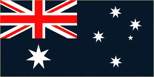
The flag and other symbols of Cook Islands
The colors, symbols, and animals on the flag usually have a historical background or an important milestone or memory of the nation.
This case is not an exception either; blue with the UK’s flag in the upper hoist-side quadrant and a large circle of 15 white five-pointed stars (one for every island) centered in the outer half of the flag.
Apart from the flag, the symbol of national unity is the national anthem. The anthem’s primary purpose is to share the nation’s core values, endeavors, and patriotic feelings.
National symbols of Cook Islands: a circle of 15, five-pointed, white stars on a blue field; national colors: blue, white.
Constitution of Cook Islands
The existence of the nation is based on the constitution. Some constitutions knew worldwide, like the U.S. Constitution that was accepted on the 17th of September 1787, in Philadelphia, the United States of America’s Constitution.
It is not related to the declaration of independence that was stolen by Nicolas Cage in the movie National Treasure 🙂
What is the legal system of the Cook Islands?
Most of the time, the legal system of a country is the focus of lawyers. It is a common fact that there are two main approaches in the world, “the law in books” and “the law in action.”
In the Anglo-Saxon world, the practice is the “law in action,” while in the rest of the world, the law is based on Roman law, the “law in books.”
The legal system of the Cook Islands is common law similar to New Zealand common law.
It was Aristotle who founded the Theory of 3 separations of powers. In his view, these are the council of public affairs, the magistrates, and the justice system. The age of enlightenment was the time when terminologies have defined the way we still use them. In most democratic countries, the three authorities separated from each other. In dictatorships, the rules usually interweaved in one hand.
About the legislative branch of the Cook Islands, we can highlight the following structures unicameral Parliament, formerly the Legislative Assembly (24 seats; members directly elected in single-seat constituencies by simple majority vote to serve 4-year terms); note – the House of Ariki, a 24-member parliamentary body of traditional leaders appointed by the Queen’s representative serves as a consultative body to the Parliament.
About the unemployment rate, labor force, and poverty line in the Cook Islands
One of the major problems of the 21st-century economy is unemployment. Governments are struggling to maintain a low level of the unemployment rate. Still, as a result of automation, the cheap 3rd world labor, and the outsourcing of workflow, these attempts fail. In the Cook Islands, the labor force is 6,820 (2001). Please bear in mind that the population in Cook Islands is total: 13.5 deaths / 1,000 live births; male: 16.3 deaths / 1,000 live births, female: 10.4 deaths / 1,000 live births (2016 estimate) – as we already mentioned above.
The rate of unemployment in the Cook Islands is 13.1% (2005).
Widely known that the gap between the rich and poor is widening on an enormous scale.
According to the 2017 shocking Oxfam report, the most affluent eight people’s fortune is equal to the wealth of the poorest half of the world’s population.
The households’ income and consumption in the Cook Islands compared to the entire population: lowest 10%: N/A% highest 10%: N/A%.
Another widely used indicator is the so-called GINI index, which measures the inequalities of statistical dispersion, but is mainly used for measuring the sharing of income and fortune.
The GINI index was named after its founder Corrado Gini, an Italian economist. Gini index has grades between 0-1, but often it is used on a percentage basis. It is 0 if the examined criteria territorial distribution is equal. It is one of the criteria concentrated on the territory.
The states usually set up a poverty line, which is more or less, is a subjective measure. It varies by country; its base is often the minimum pension, the incomes of the most deficient 20 percent, the X percent of income per capita Etc.
About the budget and central governments debt of Cook Islands
The available budget mainly defines the state’s economy. The Cook Islands budget is; revenues: $86.9 million, $77.9 million (2010). Taxes and other revenues are 35.6% of GDP (2010 estimate).
The fiscal year in the Cook Islands is 1 April – 31 March.
In the country’s economy, we have to consider the public debt. Public debt is the consolidated sum of the state’s local, federal, and central government debt.
Inflation rate and prime lending rate in the Cook Islands
A few further interesting and relevant economic data are the following; Inflation rate: 2.2% (2011 estimate) and the commercial bank prime lending rate: N/A.
Export/import partners and data of Cook Islands
The Cook Islands, with the export of products, industrial tools, and other services, generates revenue. The Cook Islands’ export value is $3.125 million (2011 estimate), $5.163 million (2010 estimate). These activities’ total revenue: copra, papayas, fresh and canned citrus fruit, coffee; fish; pearls and pearl shells; clothing.
The most important imported products are foodstuffs, textiles, fuels, timber, capital goods.
Renewable energies used in the Cook Islands
To suppress the pollution of the environment, renewable energies have to replace the fossil energy. The more the proportion of renewable energies in a country means more effort against pollution. The Cook Islands, the indicator of how much of the country’s produced energy is coming from the hydroelectric source, is 0% of total installed capacity (2012 estimate).
To indicate how much another renewable energy produced is 0.5% of total installed capacity (2012 estimate).
Telecommunication data of Cook Islands, calling code
To maintain the economy, the development of a reliable and modern telecommunications infrastructure is crucial. We can say the following about the Cook Islands; Telecom Cook Islands offers international direct dialing, Internet, email, fax, and Telex. Domestic: individual islands are connected by a combination of satellite earth stations, microwave systems, and VHF and HF radiotelephone; within the islands, service is provided by small exchanges connected to subscribers by open-wire fiber-optic cable. International: country code – 682; satellite earth station – 1 Intelsat (Pacific Ocean).
Transport infrastructure in the Cook Islands
In the 21st century, we often say that the world has become small and there are no distances anymore. With widespread air travel when (sometimes) there are no visa restrictions, it is easy to reach other countries, but if the distance is not too long, we can also use railway or water transportation.
The number of airports in the Cook Islands: 11 (2013).
The total length of the roadways in the Cook Islands: total: 320 km, paved: 33 km, unpaved: 287 km (2003).
Are you traveling to the Cook Islands?
If you plan to travel by plane to the Cook Islands, try our air ticket comparison site, where you can choose from hundreds of carriers and offers. Our application is scanning the market and shows you the best and the cheapest deals without any extra charge or commission.
Are you looking for a hotel, apartment another kind of accommodation in the Cook Islands, Oceania? We are here to help you to find your accommodation from budget to luxury. Our search engine is scanning, regularly updating data from hundreds of accommodation websites and more than a million offers. You can quickly and easily find your hotel stay anywhere in the world, without any extra charge or commission.
Facts & data about the Cook Islands
Name of the country: conventional long way: none, traditional short form: Cook Islands, etymology: named after Captain James Cook, the British explorer who visited the islands in 1773 and 1777.
| Abbreviation: Cook Islands | Geographic coordinates: 21 14 S, 159 46 W |
Country Location: Oceania |
| Capital of Cook Islands: Avarua | GPS of the Capital: 21 12 S 159 46 W |
Position: Oceania, group of islands in the South Pacific Ocean, about halfway between Hawaii and New Zealand |
| Land area: total: 236 sq km; land: 236 sq km, water: 0 sq km | Terrain: low coral atolls in north; volcanic, hilly islands in south |
Area comparative: 1.3 times the size of Washington, DC |
| Population: 9,556 (July 2016 estimate) | Population grow rate: -2.88% (2016 estimate) | Sex ratio: at birth: 1.04 male(s) / female, 0-14 years: 1.12 male(s) / female, 15-24 years: 1.14 male(s) / female, 25-54 years: 1 male(s) / female, 55-64 years: 1.17 male(s) / female, 65 years and over: 0.97 male(s) / female, total population: 1.07 male(s) / female (2016 estimate) |
| Exports: $3.125 million (2011 estimate), $5.163 million (2010 estimate) | Imports: $109.3 million (2011 estimate), $90.62 million (2010 estimate) | Import partners: N/A |
| Urbanization: urban population: 74.5% of the total population (2015) | Major urban area(s): N/A | Median age: total: 35.9 years; male: 35.3 years, female: 36.4 years (2016 estimate) |
| Internet users: total: 6,000. Percent of the population: 61% (July 2015 estimate) | Telephones (fixed-lines): total: 7,200. Subscriptions per 100 inhabitants: 61 (2009) | Telephones (mobile, cellular): total: 7,800. Subscriptions per 100 inhabitants: 66 (July 2015 estimate) |
| Unemployment rate: 13.1% (2005) | Nationality: Cook Islander(s) adjective: Cook Islander | National holidays: Constitution Day, first Monday in August (1965) |
| Life expectancy at birth: total population: 75.8 years. Male: 73 years, female: 78.8 years (2016 estimate) | Total fertility rate: 2.21 children born / woman (2016 estimate) | Birthrate: 14.1 births / 1,000 population (2016 estimate) |
| Literacy: N/A | Legal system: common law similar to New Zealand common law | Suffrage: 18 years of age, universal |
| Industries: fruit processing, tourism, fishing, clothing, handicrafts | Industrial production growth rate: 1% (2002) | GDP real growth rate: 0.1% (2005 estimate) |
Do you like this Cook Islands Google maps™ & country information page?
Please do us a favor: Share or like this page using the icons at the top of the page. We also do encourage you to visit our Facebook page for more travel and country related information.
Many thanks for visiting and sharing this map & country information site!