
Google Maps and Detailed Facts of Cameroon (CM). This page lets you explore Cameroon and its border countries (Country Location: Central Africa, bordering the Bight of Biafra, between Equatorial Guinea and Nigeria) through detailed Satellite imagery – fast and easy as never before Google Maps.
Find comprehensive information about this country’s diversity below: Google maps, geography, economy, science, people, culture, environment, government, and history – All in One Wiki page.
There is also a Street View and free Driving Directions at your service. Your Google Satellite Map Sightseeing in Cameroon, in Africa, starts here at Driving Directions and Maps.com.
Cameroon Google Maps & Satellite Maps
Situated in the Gulf of Guinea, Cameroon was effectively a one-party state for 30 years. Multiparty elections, since 1992 regularly return that same party to power. Over half the land is forested: equatorial rainforest in the north, evergreen forest, and wooded savanna in the south. Mountains in the west.
The map below shows Cameroon with its cities, towns, highways, main roads, streets, and Street Views. To find a location, use the form below, type any city or place, view a simple map, and click the “show map” button.
The Google map above shows Cameroon with its location: Africa (geographic coordinates: 6 00 N, 12 00 E) and the international borders of Cameroon; total: 5,018 km. Border countries (total: 6): Central African Republic 901 km, Chad 1,116 km, Republic of the Congo 494 km, Equatorial Guinea 183 km, Gabon 349 km, Nigeria 1,975 km; furthermore, it’s inland counties boundaries.
Hint: Look at the Street view in Cameroon or Africa. All you have to do is drag and pull the little yellow man (named: Pegman) on the Google map above the desired location. After that, whenever it is available (in more than 50 countries globally), blue stripes will appear to show the photos and details from Google’s regularly updated data image base. If you have signed in to your Google account currently, you may have a look at the satellite map of this country/area as well.
The map of Cameroon, Africa, is for informational use only. No representation is made or warrantied given any map or its content by Driving Directions and Maps site. The user assumes all risks of using this Cameroon Google map and facts/wiki.
About Cameroon in detail
| Borderline map of Cameroon | Location map of Cameroon | Flag of Cameroon |
|---|---|---|
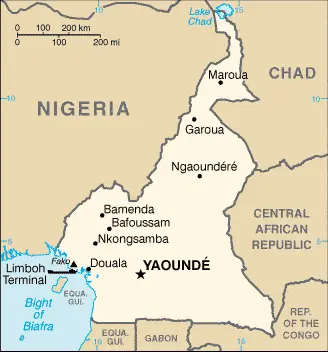 | 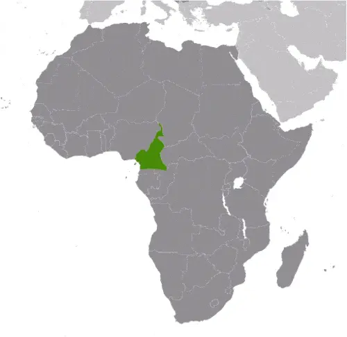 | 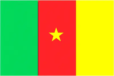 |
Where is Cameroon?
Cameroon is looking on the map under the Coordinates 3 52 N 11 31 E otherwise in Africa, in Central Africa, bordering Biafra’s Bight, between Equatorial Guinea and Nigeria.
What is the capital city of Cameroon?
The capital city of Cameroon is Yaoundé.
What is the time in Yaounde?
It is 6 hours ahead of Washington, D.C. during Standard Time; Yaounde’s timezone is UTC+1.
What is the Internet code for Cameroon?
The Top Level Domain (TLD) for Cameroon is: .cm
What is the size of Cameroon?
The territory of Cameroon is total: 475,440 sq km; land: 472,710 sq km, water: 2,730 sq km.
If we want to describe the size of the territory of Cameroon is slightly larger than California.
If we would like to walk around and discover Cameroon, we can cover a total distance: 5,018 km.
What is the water coverage of Cameroon?
We have already mentioned the percentage of Cameroon covered by water (see below), including a 402 km coastline.
What is the climate like in Cameroon?
Cameroon’s climate varies with terrain, from tropical along the coast to semiarid and hot in the north.
Geographical data of Cameroon
Cameroon’s elevation; mean elevation: 667 m, elevation extremes; lowest point: Atlantic Ocean 0 m, highest point: Fako 4,095 m.
Cameroon’s specific geographical details include a diverse coastal plain in the southwest, dissected plateau in the center, mountains in the west, and plains in the north.
Suppose we would like to describe the countries location from a different perspective. In that case, it is safe to say, and easy to read from a map, Cameroon is sometimes referred to as the hinge of Africa; throughout the country, there are areas of thermal springs and indications of current or prior volcanic activity; Mount Cameroon, the highest mountain in Sub-Saharan West Africa, is an active volcano.
Resources and land use of Cameroon
The country’s main mined products are petroleum, bauxite, iron ore, timber, hydropower. The population partly uses the earlier highlighted land territory and partly left in its natural state: agricultural land: 20.6%; arable land 13.1%; permanent crops 3.3%; permanent pasture 4.2%; forest: 41.7%; other: 37.7% (2011 estimate).
Population data of Cameroon
The number of inhabitants of Cameroon is 24,360,803 (July 2016 estimate).
If we examine the proportion of the population distribution, it is safe to say that N/A.
If we look at the proportion of the urbanized and barely populated areas, these are the urban population: 54.4% of the total population (2015).
Cameroon’s population is concentrated in YAOUNDE (capital) 3.066 million; Douala 2.943 million (2015).
Ethnicity in Cameroon
According to ethnicity details, the ethnic groups are Cameroon Highlanders 31%, Equatorial Bantu 19%, Kirdi 11%, Fulani 10%, Northwestern Bantu 8%, Eastern Nigritic 7%, other African 13%, non-African less than 1%.
Spoken languages in Cameroon
Cameroon’s spoken languages are 24 major African language groups, English (official language), French (official language).
What are the most important religions in Cameroon?
During the general census, researchers examine the churches, according to this: Catholic 38.4%, Protestant 26.3%, other Christian 4.5%, Muslim 20.9%, animist 5.6%, additional 1%, non-believer 3.2% (2005 estimate).
Further population data of Cameroon
The proportion of gender and age tells a lot about the society as follows 0-14 years: 42.6% (male 5,228,047 / female 5,149,228) 15-24 years: 19.55% (male 2,393,598 / female 2,368,557) 25-54 years: 30.71% (male 3,762,054 / female 3,718,266) 55-64 years: 3.97% (male 471,306 / female 495,462) 65 years and over: 3.18% (male 360,386 / female 413,899) (2016 estimate). It also a significant factor in a society the population growth rate, which in the case of Cameroon is 2.58% (2016 estimate).
The population growth rate is based on two elements, birth and the death rate. In Cameroon the birth rate is 35.8 births / 1,000 population (2016 estimate), the death rate 9.8 deaths / 1,000 population (2016 estimate).
In this day and age in developed societies, the first child borns later compared to the previous centuries and decades, so childbearing is extended. In Cameroon, the average age of mothers at the first childbirth is N/A.
Although the children’s birth is postponed in the best-case scenario, the parents can still see their kids grow as life expectancy also extended. In the case of Cameroon, these figures are. With the introduction of modern medicine, vaccinations, and proper hygienic conditions, the infant mortality rate is in a steep decline. The infant mortality statistics in Cameroon are the following: N/A. Relevant data is the budget of healthcare, which is 4.1% of GDP (2014).
Economic data of Cameroon
Suppose we would like to describe a country. We also have to mention its economy; the Modest oil resources and favorable agricultural conditions provide Cameroon with one of the best-endowed primary commodity economies in Sub-Saharan Africa. Oil remains Cameroon’s main export commodity. Despite falling global oil prices, still accounts since1990, the government has embarked on various IMF and World Bank programs designed to spur business investment, increase efficiency in agriculture, improve trade, and recapitalize the nation’s banks. The IMF continues to press for economic reforms. Cameroon devotes significant resources to several large infrastructure projects under construction, including a deep seaport in Kribi and the Lom Pangar Hydropower Project.
GDP is a prominent figure, as all the relevant calculations and statistics are based on it. GDP in Cameroon is $30.87 billion (2015 estimate).
Another important indicator is the rate of GDP growth, which in Cameroon is 4.8% (2016 estimate), 5.8% (2015 estimate) 5.9% (2014 estimate).
These statistics affect the world economy; remember, in 2015, the Chinese real GDP growth rate was worse than expected; The world markets fall, and the Chinese stock exchange is temporally suspended.
A further major factor of a country’s economy, the GDP per capita. In Cameroon this is $3,300 (2016 estimate) $3,200 (2015 estimate) $3,100 (2014 estimate).
The Trinity is in common places in the economy, such as agriculture, industry, and services.
What are the agricultural products Cameroon produces?
Cameroon’s main agricultural products are coffee, cocoa, cotton, rubber, bananas, oilseed, grains, cassava (manioc, tapioca), livestock, timber.
The essential segments are petroleum production and refining, aluminum production, food processing, light consumer goods, textiles, lumber, sand hip repair. The crucial and regularly mentioned GDP is based on petroleum production and refining, aluminum production, food processing, light consumer goods, textiles, lumber, ship repair.
Drinking water source in Cameroon
It is essential to mention that – thanks to the development of the infrastructure -, the rate of potable water improved: urban: 94.8% of the population, rural: 52.7% of the population, total: 75.6% of the community. Unimproved: urban: 5.2% of the population, rural: 47.3% of the population, total: 24.4% (2015 estimate).
The average number of childbirth in Cameroon
In Cameroon, the average delivery number is 4.7 children born / woman (2016 estimate).
Population, median age, migration, and citizenship in Cameroon
The population’s average age is 18.5 years; male: 18.4 years, female: 18.6 years (2016 estimate). The age of adulthood varies in every country of the world. Cameroon is 20 years of age, universal.
When we are experiencing an unprecedented scale of migration and globalization, it is an important factor in the number of new immigrants. In Cameroon is -0.1 migrant(s) / 1,000 population (2016 estimate). It is important to know how to apply for citizenship: citizenship by birth: no. Citizenship by descent only: at least one parent must be a citizen of Cameroon. Dual citizenship recognized: no.—residency requirement for naturalization: 5 years.
Is Cameroon a safe destination? Healthcare services and infectious diseases in Cameroon
Many of the travelers are looking into the healthcare services and infectious diseases of their destinations. In Cameroon, the hospital beds’ density is 1.3 beds / 1,000 population (2010).
According to the WHO rating regarding contagious diseases in Cameroon, the degree of risk: very high food or waterborne diseases: bacterial and protozoal diarrhea, hepatitis A, and typhoid fever vectorborne diseases: malaria, dengue fever, and yellow fever water contact disease: schistosomiasis respiratory disease: meningococcal meningitis animal contact disease: rabies (2016).
However, HIV is not curable but maintainable. Let’s do not forget when the disease surfaced, it was a world-threatening condition. Unfortunately, in some countries, it is still very high the number of infected patients and fatalities due to the disease.
In Cameroon, the number of HIV/AIDS deaths: N/A.
Regarding tourism obesity, not an important issue, but we have to mention health statistics, as it is the plague of the 20th and the 21st century. The rate of obese adults in Cameroon is 9.6% (2014).
What are the natural hazards in Cameroon? Is there any?
The most known natural risk in Cameroon are volcanic activity with periodic releases of poisonous gases from Lake Nyos and Lake Monoun volcanoes, volcanism: Mt. Cameroon (elevation 4,095 m), which last erupted in 2000, is the most frequently active volcano in West Africa; lakes in Oku volcanic field have released fatal levels of gas on occasion, killing some 1,700 people in 1986.
More interesting facts about Cameroon
A few words about the past, as every country and society is connected to its history; French Cameroon became independent in 1960 as the Republic of Cameroon. The following year the southern portion of neighboring British Cameroon voted to merge with the new country to form the Federal Republic of Cameroon. In 1972, a new constitution replaced the federation with a unitary state, the United Republic of Cameroon. The country has generally enjoyed stability, which has enabled agriculture, roads, railways, and the petroleum industry. Despite slow movement toward democratic reform, political power remains firmly in the hands of President Paul BIYA.
In every nation’s memory, some cornerstones placed the country on the timeline of history. The date of declaration of independence of Cameroon: 1 January 1960 (from French-administered UN trusteeship).
The flag and other symbols of Cameroon
The colors, symbols, and animals on the flag usually have a historical background or an important milestone or memory of the nation.
This case is not an exception either; three equal vertical bands of green (hoist side), red, and yellow, with a yellow five-pointed star centered in the red band; the vertical tricolor recalls the flag of France; red symbolizes unity, yellow the sun, happiness, and the savannahs in the north, and green hope and the forests in the south; the star is referred to as the “star of unity.” Note: uses the popular Pan-African colors of Ethiopia.
Apart from the flag, the symbol of national unity is the national anthem. The anthem’s primary purpose is to share the nation’s core values, endeavors, and patriotic feelings.
National symbols of Cameroon: lion; national colors: green, red, yellow.
Constitution of Cameroon
The existence of the nation is based on the constitution. Some constitutions knew worldwide, like the U.S. Constitution accepted on the 17th of September 1787, in Philadelphia, the United States of America’s Constitution.
It is not related to the declaration of independence that Nicolas Cage stole in the movie National Treasure 🙂
What is the legal system of Cameroon?
Most of the time, the legal system of a country is the focus of lawyers. It is a common fact that there are two main approaches in the world, “the law in books” and “the law in action.”
In the Anglo-Saxon world, the practice is the “law in action,” while in the rest of the world, the law is based on Roman law, the “law in books.”
Cameroon’s legal system is a mixed legal system of English common law, French civil law, and customary law.
It was Aristotle who founded the Theory of 3 separations of powers. In his view, these are the council of public affairs, the magistrates, and the justice system. The age of enlightenment was the time when terminologies have defined the way we still use them. In most democratic countries, the three authorities separated from each other. In dictatorships, the rules usually interweaved in one hand.
About the legislative branch of Cameroon, we can highlight the following structures bicameral Parliament or Parlement consists of the Senate or Senat (100 seats; 70 members indirectly elected by regional councils and 30 appointed by the president; members serve 5-year terms) and the National Assembly or Assemblee Nationale (180 seats; members directly elected in multi-seat constituencies by simple majority vote to serve 5-year terms); note – the 100-member Senate was formed at the time of the April 2013 election.
About the unemployment rate, labor force, and poverty line in Cameroon
One of the major problems of the 21st-century economy is unemployment. Governments are struggling to maintain a low level of unemployment rate. As a result of automation, the cheap 3rd world labor, and the outsourcing of workflow, these attempts fail in Cameroon; the labor force is 9.612 million (2016 estimate). Please bear in mind that the population in Cameroon is total: 52.2 deaths / 1,000 live births; male: 55.8 deaths / 1,000 live births, female: 48.5 deaths / 1,000 live births (2016 estimate) – as we already mentioned above.
The rate of unemployment in Cameroon is 30% (2001 estimate).
Widely known that the gap between the rich and poor is widening on an enormous scale.
According to the 2017 shocking Oxfam report, the most affluent eight people’s fortune is equal to the wealth of the poorest half of the world’s population.
In Cameroon, the households’ income and consumption compared to the entire population: lowest 10%: 2.3% highest 10%: 35.4% (2001).
Another widely used indicator is the so-called GINI index, which measures the inequalities of statistical dispersion, but is mainly used for measuring the sharing of income and fortune.
The GINI index was named after its founder Corrado Gini, an Italian economist. Gini index has grades between 0-1, but often it is used on a percentage basis. It is 0 if the examined criteria territorial distribution is equal. It is one of the criteria concentrated on the territory. In Cameroon, the GINI index is .44,6 (2001).
The states usually set up a poverty line, which is more or less, is a subjective measure. It varies by country; its base is often the minimum pension, the most deficient 20 percent, the X percent of income per capita, etc.
In Cameroon, the poverty line people are the lowest 10%: 2.3% highest 10%: 35.4% (2001).
About the budget and central governments debt of Cameroon
The available budget mainly defines the state’s economy. Cameroon’s budget is; revenues: $4.765 billion, expenditures: $6.497 billion (2016 estimate). Taxes and other revenues are 15.4% of GDP (2016 estimate).
The budget deficit (Budget surplus (+) or deficit (-)) is N/A.
The fiscal year in Cameroon is 1 July – 30 June.
In the country’s economy, we have to consider the public debt. Public debt is the consolidated sum of the state’s local, federal, and central government debt.
Inflation rate and prime lending rate in Cameroon
A few further interesting and relevant economic data are the following; Inflation rate: 2.4% (2016 estimate), 2.7% (2015 estimate), and the rate of the Commercial bank prime lending rate: 12.5% (31 December 2016 estimate).
Export/import partners and data of Cameroon
Cameroon, with the export of products, industrial tools, and other services, generates revenue. Cameroon’s export value is $5.559 billion (2016 estimate), $5.756 billion (2015 estimate). The total revenue of these activities: crude oil and petroleum products, lumber, cocoa beans, aluminum, coffee, cotton.
The most important export partners of Cameroon are the China 16.7%, India 15.7%, Spain 6.2%, Belgium 6.1%, France 6.1%, Portugal 5.6%, Netherlands 5%, Italy 5% (2015).
The most important imported products are machinery, electrical equipment, transport equipment, fuel, food, and the countries from where the import is coming: China 27.9%, Nigeria 13.9%, France 10.9%, Belgium 4.1% (2015).
Renewable energies used in Cameroon
To suppress the pollution of the environment, renewable energies have to replace fossil energy. The more the proportion of renewable energies in a country means more effort against the pollution. Cameroon indicates how much of the country’s produced energy comes from the hydroelectric source, 71.5% of the total installed capacity (2012 estimate).
To indicate how much another renewable energy produced is 0% of total installed capacity (2012 estimate).
Telecommunication data of Cameroon, calling code
To maintain the economy, the development of a reliable and modern telecommunications infrastructure is crucial. We can say the following about Cameroon; system includes cable, microwave radio relay, and tropospheric scatter; Camtel, the monopoly provider of fixed-line service, provides connections for only about 4 per 100 persons; equipment is old and outdated, and connections with many parts of the domestic mobile-cellular usage, in part a reflection of the poor condition and general inadequacy of the fixed-line network, has increased sharply, reaching a subscribership base of 70 per 100 persons. International: country code – 237; landing point for the SAT-3/WASC fiber-optic submarine cable connecting Europe and Asia; satellite earth stations – 2 Intelsat (Atlantic Ocean) (2015).
Transport infrastructure in Cameroon
In the 21st century, we often say that the world has become small and there are no distances anymore. With widespread air travel when (sometimes) there are no visa restrictions, it is easy to reach other countries, but if the distance is not too long, we can also use railway or water transportation.
The number of airports in Cameroon: 33 (2013), and the number of heliports: N/A.
The total length of the roadways in Cameroon: total: 51,350 km, paved: 4,108 km, unpaved: 47,242 km, note: there is 28,857 km of national roads (2011).
The total length of the waterways in Cameroon: (significant rivers in the south, such as the Wouri and the Sanaga, are largely non-navigable; in the north, the Benue, which connects through Nigeria to the Niger River, is navigable in the rainy season only to the port of Garoua) (2010).
Facts & data about Cameroon
Name of the country: conventional long way: the Republic of Cameroon, traditional short form: Cameroon, local long form: the Republique du Cameroun/Republic of Cameroon, local short state: Cameroun/Cameroon, former: French Cameroon, British Cameroon, Federal Republic of Cameroon, United Republic of Cameroon, etymology: in the 15th century, Portuguese explorers named the area near the mouth of the Wouri River the Rio dos CCamarones(River of Prawns) after the abundant shrimp in the water; over time the designation became Cameroon in English; this is the only instance where a country is named after a crustacean.
| Abbreviation: Cameroon | Geographic coordinates: 6 00 N, 12 00 E | Country Location: Africa |
| Capital of Cameroon: Yaounde | GPS of the Capital: 3 52 N 11 31 E | Position: Central Africa, bordering the Bight of Biafra, between Equatorial Guinea and Nigeria |
| Land area: total: 475,440 sq km; land: 472,710 sq km, water: 2,730 sq km | Terrain: diverse, with coastal plain in southwest, dissected plateau in center, mountains in the west, plains in the north | Area comparative: slightly larger than California |
| Population: 24,360,803 (July 2016 estimate) | Population grow rate: 2.58% (2016 estimate) | Sex ratio: at birth: 1.03 male(s) / female, 0-14 years: 1.02 male(s) / female, 15-24 years: 1.01 male(s) / female, 25-54 years: 1.01 male(s) / female, 55-64 years: 0.95 male(s) / female, 65 years and over: 0.87 male(s) / female, total population: 1.01 male(s) / female (2016 estimate) |
| Exports: $5.559 billion (2016 estimate), $5.756 billion (2015 estimate) | Imports: $6.63 billion (2016 estimate), $6.5 billion (2015 estimate) | Import partners: China 27.9%, Nigeria 13.9%, France 10.9%, Belgium 4.1% (2015) |
| Urbanization: urban population: 54.4% of the total population (2015) | Major urban area(s): YAOUNDE (capital) 3.066 million; Douala 2.943 million (2015) | Median age: total: 18.5 years; male: 18.4 years, female: 18.6 years (2016 estimate) |
| Internet users: total: 4.909 million. Percent of the population: 20.7% (July 2015 estimate) | Telephones (fixed-lines): total subscriptions: 1,054,978. Subscriptions per 100 inhabitants: 4 (July 2015 estimate) | Telephones (mobile, cellular): total: 16.807 million. Subscriptions per 100 inhabitants: 71 (July 2015 estimate) |
| Unemployment rate: 30% (2001 estimate) | Nationality: Cameroonian(s) adjective: Cameroonian | National holidays: State Unification Day (National Day), 20 May (1972) |
| Life expectancy at birth: total population: 58.5 years. Male: 57.1 years, female: 59.9 years (2016 estimate) | Total fertility rate: 4.7 children born / woman (2016 estimate) | Birthrate: 35.8 births / 1,000 population (2016 estimate) |
| Literacy: age 15 and over can read and write. Total population: 75%; male: 81.2%, female: 68.9% (2015 estimate) | Legal system: mixed legal system of English common law, French civil law, and customary law | Suffrage: 20 years of age, universal |
| Industries: petroleum production and refining, aluminum production, food processing, light consumer goods, textiles, lumber, ship repair | Industrial production growth rate: 5.2% (2016 estimate) | GDP real growth rate: 4.8% (2016 estimate) 5.8% (2015 estimate) 5.9% (2014 estimate) |
Do you like this Cameroon Google maps™ & country information page?
Would you please do us a favor: Share or like this page using the icons at the top of the page? We also do encourage you to visit our Facebook page for more travel and country-related information.
Many thanks for visiting and sharing this map & country information site!