
Google Maps and Detailed Facts of Brunei (BX). This page lets you explore Brunei and its border countries (Country Location: Southeastern Asia, along the northern coast of the island of Borneo, bordering the South China Sea and Malaysia) through detailed Satellite imagery – fast and easy as never before Google Maps.
Find comprehensive information about this country’s diversity below: Google maps, geography, economy, science, people, culture, environment, government, and history – All in One Wiki page.
There is also a Street View and free Driving Directions at your service. Your Google Satellite Map Sightseeing in Brunei in Southeast Asia starts at Driving Directions and Maps.com.
About Brunei in detail
| Borderline map of Brunei | Location map of Brunei | Flag of Brunei |
|---|---|---|
 | 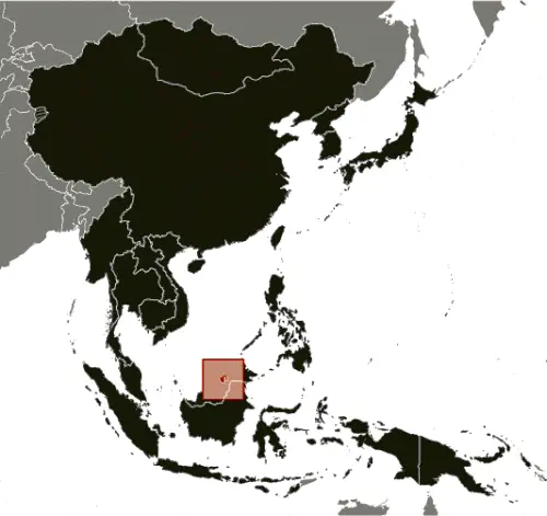 | 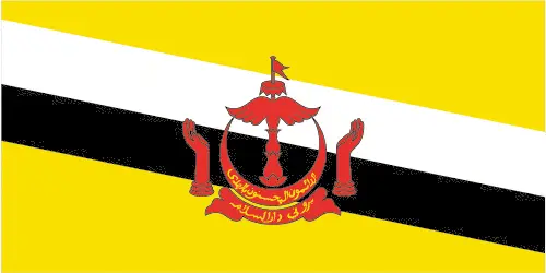 |
Table of contents
- Background
- Overview
- Google Maps
- Climate
- Geography
- Resources and Land Use
- Population Data
- Economic Data
- Drinking Water Source
- Population, Median Age, Migration, and Citizenship
- Average Number of Childbirths
- Is this country a Safe Destination?
- Healthcare and Infectious Diseases
- Natural Hazards
- The Flag and Other Symbols
- Constitution
- Legal System
- About the Unemployment Rate, Labor Force, and Poverty Line
- About the Budget and Central Government Debt
- Inflation Rate and Prime Lending Rate
- Export/Import Partners and Data
- Renewable Energies Used
- Telecommunication Data, Calling Code
- Transport Infrastructure
- More Interesting Facts
Background
Brunei, officially known as the Sultanate of Brunei, experienced its peak influence between the 15th and 17th centuries, with its control extending over areas of northwest Borneo and the southern Philippines. Following a period of decline due to internal strife, European colonial expansion, and piracy, Brunei became a British protectorate in 1888. It achieved independence in 1984. The nation, ruled by the same family for over six centuries, is notably wealthy due to its extensive petroleum and natural gas fields.
Overview
Official Name: Brunei Darussalam
Capital: Bandar Seri Begawan
Population: 484,991 (2023 estimate)
Total Area: 5,765 sq km
Languages: Malay (Bahasa Melayu) (official), English, Chinese dialects
Religions: Muslim (official) 82.1%, Christian 6.7%, Buddhist 6.3%, other 4.9%
Ethnic Groups: Malay 67.4%, Chinese 9.6%, other 23%
Government: Absolute monarchy or sultanate
Currency: Bruneian Dollar (BND)
Literacy Rate: 97.6%
GDP (Purchasing Power Parity): $26.779 billion (2021 estimate)
Google Maps
Brunei, located in Southeastern Asia along the northern coast of Borneo, is accessible through Google Maps. This platform allows users to virtually explore Brunei’s unique geography, including its lush rainforests, pristine beaches, and the capital city, Bandar Seri Begawan.
Lying on the northern coast of the island of Borneo, Brunei is surrounded and divided in two by the Malaysian state of Sarawak. It has been independent since 1984. Mostly dense lowland rainforest and mangrove swamps, with some mountains in the southeast.
The map below shows Brunei’s cities, towns, highways, main roads, streets, and Street Views. To find a location, use the form below, type any city or place, view a simple map, and click the “show map” button.
The Google map above shows Brunei with its location: Southeast Asia (geographic coordinates: 4 30 N, 114 40 E) and the international borders of Brunei; total: 266 km. Border countries (total: 1): Malaysia 266 km; furthermore, it’s inland counties boundaries.
The map of Brunei, Southeast Asia, is for informational use only. No representation is made or warrantied given any graph or content by the Driving Directions and Maps site. The user assumes all risks of using this Brunei Google map and facts/wiki.
Climate
Brunei, located on the island of Borneo in Southeast Asia, experiences a tropical rainforest climate, profoundly influencing its environment and ecosystems. Here’s an extended look at Brunei’s climate and its implications:
- High Temperatures and Humidity: The climate in Brunei is consistently hot and humid throughout the year. Average daytime temperatures typically range from 28°C to 33°C (82°F to 91°F), with high humidity levels often exceeding 80%.
- Rainfall Patterns: Brunei has a high annual rainfall, averaging between 2,500 mm and 3,000 mm. The country experiences two monsoon seasons: the Northeast Monsoon from December to March, which brings heavier rainfall, and the Southwest Monsoon from June to September, generally lighter.
- Inter-Monsoon Periods: The periods between the monsoons, particularly April to May and September to October, are characterized by relatively lower rainfall. However, even during these times, short, heavy showers are common in the afternoons and evenings.
- Impact on Ecosystems: Brunei’s warm, wet climate is ideal for tropical rainforests, which cover a significant portion of the country. These rainforests are among the most biodiverse in the world, home to a wide range of flora and fauna, including rare and endangered species.
- Biodiversity Hotspots: Brunei’s rainforests are rich in biodiversity. They provide habitat for many species, such as the Bornean elephant, proboscis monkey, and many bird and insect species. The rainforests also house numerous plant species, many of which are endemic to Borneo.
- Conservation Efforts: Recognizing the importance of its natural heritage, Brunei has made significant efforts to conserve its rainforests. Most of the country’s land area is designated as protected forests and national parks.
- Climate Change Impacts: Like many other regions, Brunei is affected by climate change. Issues of concern include rising temperatures, changes in rainfall patterns, and potential impacts on its delicate ecosystems, particularly the rainforests and mangrove swamps.
- Mangroves and Wetlands: Besides rainforests, Brunei’s climate supports extensive mangrove forests and wetlands along its coastline. These ecosystems are crucial for coastal protection, biodiversity, and supporting local fisheries.
- Air Quality and Haze: Brunei occasionally experiences haze, particularly during forest fires in neighboring regions. This haze can impact air quality and is closely linked to regional land-use practices and climate conditions.
- Agriculture and Climate: Brunei’s climate supports various agricultural activities. The high rainfall and fertile soil suit crops such as rice, fruits, and vegetables. However, agriculture plays a relatively small role in the country’s economy, heavily based on oil and gas exports.
Brunei’s tropical climate, characterized by high temperatures, humidity, and significant rainfall, supports its diverse rainforests and rich biodiversity. While providing ideal conditions for lush ecosystems, this climate also brings challenges related to conservation, climate change impacts, and sustainable development.
Geography
Brunei, a small but geographically diverse nation on the island of Borneo, offers a range of terrains and natural features. Here’s an extended overview of its geographical characteristics, along with information about its neighboring countries:
- Location on Borneo: Brunei occupies a small section of the northern coast of Borneo, the third-largest island in the world. Its position on this island places it in a region known for its rich biodiversity and complex ecosystems.
- Bordering the South China Sea: To the north, Brunei has a coastline along the South China Sea, which provides significant marine resources and is crucial for its economy, particularly regarding fisheries and oil reserves.
- Malaysia as the Only Land Neighbor: Brunei is unique in being surrounded by a single country – Malaysia. Specifically, it is bordered by the Malaysian state of Sarawak. This significant border divides Brunei into two parts: an eastern and a western enclave.
- Terrain Diversity: The country’s terrain varies from flat coastal plains along the northern seafront to hilly and mountainous regions inland. Most of the population lives in the coastal plains, where most economic activities occur.
- Bukit Pagon: The Highest Peak: Bukit Pagon, with an elevation of 1,850 meters (6,070 feet), is the highest point in Brunei. This mountainous region in the east is part of the larger Crocker Range, which extends into Malaysia.
- Hilly Lowlands in the West: The western part of Brunei is characterized by hilly lowlands rich in biodiversity. These areas contain a mix of secondary and primary rainforests, some protected reserves.
- Rivers and Waterways: Brunei features several rivers, with the Brunei River being the most prominent. This river is an important waterway for transport and commerce and holds historical significance as the site of the nation’s capital, Bandar Seri Begawan.
- Rainforests and Protected Areas: A significant portion of Brunei’s land is covered by dense tropical rainforests. These rainforests are part of Borneo’s extensive rainforest, one of the oldest and most biologically diverse in the world.
- Ecological and Environmental Significance: The country’s forests are home to various flora and fauna, including species endemic to Borneo. Conservation efforts are in place to protect these valuable ecosystems, especially against the threats of deforestation and habitat loss.
- Natural Resources: Brunei’s geographical location has endowed it with rich natural resources, particularly oil and natural gas, which are the backbone of its economy. The nation’s territorial waters in the South China Sea are also important for offshore oil and gas exploration.
Brunei’s geography, marked by its coastal plains, mountainous terrain, lush rainforests, and singular border with Malaysia, shapes its unique ecological, cultural, and economic landscape. The nation’s commitment to preserving its natural environment is evident in its extensive rainforests and protected areas, which are crucial for maintaining regional biodiversity.
Resources and Land Use
Brunei’s wealth primarily comes from petroleum and natural gas. Land use includes 2.5% agricultural land, with a significant portion of the country covered by forests (71.8%).
Population Data
Brunei has a small population, with the majority living along the coast in the western part, particularly in and around Bandar Seri Begawan. Immigrants make up approximately 26% of the population.
Economic Data
Brunei’s economy is almost exclusively reliant on oil and gas, contributing to its status as a high-income country. The government employs the majority of the workforce.
Drinking Water Source
In Brunei, 99.9% of the population can access improved drinking water sources.
Population, Median Age, Migration, and Citizenship
The median age in Brunei is 32 years. Brunei sees a net migration rate of 2.2 migrants/1,000 population. Citizenship is typically granted by descent, with strict naturalization requirements.
Average Number of Childbirths
The total fertility rate in Brunei is 1.74 children born/woman, indicating a below-replacement level of childbirths.
Is this country a Safe Destination?
Brunei is generally considered safe for travelers, with low crime rates. However, visitors should be aware of local laws and customs.
Healthcare and Infectious Diseases
Healthcare in Brunei is accessible, with a current health expenditure of 2.4% of GDP. Common infectious diseases are typical of the Southeast Asian region.
Natural Hazards
Brunei’s Natural hazards include rare typhoons, earthquakes, and severe flooding.
The Flag and Other Symbols
The national flag of Brunei is yellow with two diagonal bands of white and black, featuring the national emblem in red at the center. The emblem symbolizes various national values and Islam, the state religion.
Constitution
Brunei’s constitution, initially drafted between 195 4 and 1959, has undergone several amendments, with some provisions suspended since 1962 and others since 1984.
Legal System
Brunei has a mixed legal system based on English common law and Islamic law. Sharia penal codes, applicable to Muslims and partly to non-Muslims, came into full force in April 2019.
About the Unemployment Rate, Labor Force, and Poverty Line
The unemployment rate in Brunei was estimated at 7.65% in 2021. Poverty line data is not specified.
About the Budget and Central Government Debt
Brunei’s public debt is relatively low, at 2.8% of GDP in 2017. The fiscal year runs from April 1 to March 31.
Inflation Rate and Prime Lending Rate
The inflation rate in Brunei was 1.73% in 2021. The prime lending rate is not specified.
Export/Import Partners and Data
Major export partners include Singapore, China, and Japan, with key exports like refined petroleum and natural gas. Imports mainly come from Singapore, China, and Malaysia, including crude petroleum and cars.
Renewable Energies Used
Brunei’s electricity generation is almost entirely from fossil fuels, with a negligible contribution from renewable sources.
Telecommunication Data, Calling Code
Brunei has a growing telecommunications infrastructure with significant mobile cellular subscriptions. The country code is +673.
Transport Infrastructure
Transportation in Brunei includes an extensive road network, one major airport with paved runways, and several heliports. The country also has a notable merchant marine fleet.
More Interesting Facts
Brunei is known for its lush rainforests, rich Islamic culture, and the opulent lifestyle of its monarchy. It is also recognized for its commitment to preserving its natural environment and implementing strict laws to maintain social order.
Did You Know?
- Only Southeast Asian Sultanate: Brunei is Southeast Asia’s only remaining sovereign sultanate. The Sultan of Brunei is one of the world’s longest-reigning and few remaining absolute monarchs.
- Rich in Oil and Gas: This small country is wealthy due to its extensive petroleum and natural gas fields. Brunei’s per capita income is one of the highest in the world, thanks to these resources.
- Two-Part Country: Brunei is geographically unusual as it is split into two parts, with both sections surrounded by the Malaysian state of Sarawak.
- Bukit Pagon, the Highest Peak: At 1,850 meters (6,070 feet), Bukit Pagon is Brunei’s highest point and a significant ecological site hosting diverse flora and fauna.
- Largest Residential Palace in the World: The Istana Nurul Iman palace, the official residence of the Sultan of Brunei, is the largest residential palace in the world and even holds a record in the Guinness World Records for this feat.
- Almost Entirely Covered in Rainforest: Over 70% of Brunei’s land area is covered by pristine rainforest, much of it protected as national parks, making it a haven for biodiversity.
- No Personal Income Tax: Despite its wealth, Brunei does not levy a personal income tax on its residents, which is a rarity today.
- Home to Rare Wildlife: The rainforests of Brunei are home to some of the rarest animals in the world, such as the Bornean elephant, proboscis monkey, and various species of hornbills.
- Water Village: The Kampong Ayer in Brunei’s capital, Bandar Seri Begawan, is a large water village built on stilts above the Brunei River. It is known as the “Venice of the East” and is a significant cultural and historical site.
- Conservation Efforts: Brunei is committed to preserving its natural environment, with numerous initiatives to protect its forests and wildlife, particularly in the face of global environmental challenges.
- Unique Cuisine: Bruneian cuisine blends Malay, Chinese, Indian, and indigenous cooking styles, offering unique dishes such as Ambuyat, a sticky sago starch that’s a national delicacy.
These interesting facts about Brunei highlight its unique blend of rich cultural heritage, natural wealth, and commitment to environmental conservation, making it a distinctive country in Southeast Asia.
Many thanks for visiting and sharing this map & country information site!