
Google Maps and Detailed Facts about Anguilla (AI). This page lets you explore Anguilla and its border countries (Country Location: the Caribbean, islands between the Caribbean Sea and North Atlantic Ocean, east of Puerto Rico) through detailed Satellite imagery – fast and easy as never before Google Maps.
Find comprehensive information about this country’s diversity below: Google maps, geography, economy, science, people, culture, environment, government, and history – All in One Wiki page.
There is also a Street View and free Driving Directions at your service. Your Google Satellite Map Sightseeing in Anguilla, Central America and the Caribbean starts here at Driving Directions and Maps.com.
| Borderline map of Anguilla | Location map of Anguilla | Flag of Anguilla |
|---|---|---|
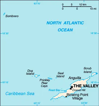 | 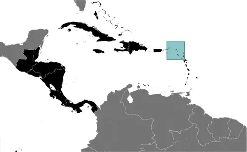 | 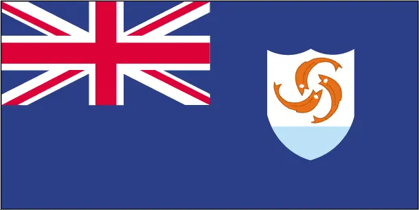 |
Table of contents
- Background
- Overview
- Google Maps
- Climate
- Geography
- Resources and Land Use
- Population Data
- Economic Data
- Drinking Water Source
- Population, Median Age, Migration, and Citizenship
- Average Number of Childbirths
- Is this country a Safe Destination?
- Healthcare and Infectious Diseases
- Natural Hazards
- The Flag and Other Symbols
- Constitution
- Legal System
- About the Unemployment Rate, Labor Force, and Poverty Line
- About the Budget and Central Government Debt
- Inflation Rate and Prime Lending Rate
- Export/Import Partners and Data
- Renewable Energies Used
- Telecommunication Data, Calling Code
- Transport Infrastructure
- More Interesting Facts
Background
Anguilla, a small island in the Caribbean, was colonized by English settlers from Saint Kitts in 1650. Initially administered by Great Britain, it was incorporated into a single British dependency along with Saint Kitts and Nevis in the early 19th century, against the inhabitants’ wishes. After several unsuccessful attempts at separation and a revolt in 1967, Anguilla was finally allowed to secede in 1971, a status formally recognized in 1980, becoming a separate British dependency. The island suffered extensive damage from Hurricane Irma in 2017, impacting its communications, residential, and business infrastructure.
Overview
Anguilla is a British Overseas Territory in the Caribbean, known for its stunning beaches and vibrant tourism industry. Despite its small size, the island has developed a robust economy centered around tourism, boat building, and offshore financial services. The governance system is a parliamentary democracy, with Anguilla self-governing while retaining ties to the UK.
Official Name: Anguilla
Date of Formation: Became a separate British dependency in 1980
Capital: The Valley
Population: Approximately 19,079 (2023 estimate)
Total Area: 91 square kilometers (35 square miles)
Population Density: N/A
Languages: English (official)
Religions: Predominantly Christian
Ethnic Origin: Majority of African descent
Government: British Overseas Territory
Currency: East Caribbean dollar (XCD)
Literacy Rate: N/A
Calorie Consumption: N/A
Anguilla Google Maps
With Google Maps, one can explore Anguilla’s geography, including its location between the Caribbean Sea and the North Atlantic Ocean, east of Puerto Rico. This tool is particularly useful for tourists visiting the island’s numerous beaches and resorts.
The map below shows Anguilla’s cities, towns, highways, main roads, streets, and Street Views. To find a location, use the form below, type any city or place, view a simple map, and click the “show map” button.
The Google map above shows Anguilla with its location: Central America and the Caribbean (geographic coordinates: 18 15 N, 63 10 W) and the international borders of Anguilla; 0 km; furthermore, its inland counties boundaries.
The map of Anguilla, Central America, and the Caribbean is for informational use only. No representation is made or warrantied given any map or its content by Driving Directions and Maps site. The user assumes all risks of using this Anguilla Google map and facts/wiki.
Climate
Anguilla’s climate, characterized by its tropical nature, is significantly influenced by its geographical location in the Caribbean. This setting results in a generally warm, sunny, and inviting climate, making it an attractive destination for tourists throughout the year. Here’s an extended overview of Anguilla’s climatic conditions, incorporating factual and interesting aspects:
-
- Moderating Influence of Trade Winds: The northeast trade winds play a crucial role in moderating the climate of Anguilla. These prevalent winds throughout the year help temper the heat and bring a refreshing breeze, contributing to the island’s comfortable climate.
-
- Temperature Range: Anguilla enjoys a warm tropical climate with relatively consistent temperatures year-round. The average temperature typically ranges from about 24°C to 30°C (75°F to 86°F). The warmest months are usually from June to October, while the period from December to February is slightly cooler.
-
- Rainfall Patterns: Anguilla receives moderate rainfall, with the wettest period typically occurring from August to November. The average annual rainfall is about 1,000 to 1,150 mm (39 to 45 inches). Rain showers are usually short-lived, and the sun often reappears quickly after a downpour.
-
- Dry Season: The dry season in Anguilla runs from December to April. During this period, the island experiences less rainfall, making it a popular time for tourists seeking sunny, dry weather. This season coincides with the peak tourist season.
-
- Hurricane Season: Like many Caribbean islands, Anguilla is susceptible to hurricanes. The hurricane season officially runs from June to November, with the highest likelihood of storms typically occurring between August and October. Despite this, Anguilla has a robust infrastructure and is well-prepared for such events.
-
- Humidity Levels: The humidity in Anguilla is relatively high, as is typical for tropical islands. However, the trade winds usually help to make the humidity feel less oppressive, especially along the coast.
-
- Sunshine Hours: Anguilla is blessed with abundant sunshine. On average, the island enjoys about 8 to 9 hours of sunshine daily, contributing to its reputation as a sunny, pleasant destination.
-
- Water Temperature: The surrounding waters of Anguilla maintain a warm temperature year-round, typically ranging from 26°C to 29°C (79°F to 84°F). This makes it ideal for swimming, snorkeling, and other water activities at any time of the year.
-
- Impact on Tourism: The tropical climate of Anguilla is a significant draw for tourists, particularly those from colder climates. The consistently warm weather and beautiful beaches make it a favored destination for vacations, weddings, and honeymoons.
-
- Environmental Considerations: Being a small island, Anguilla is sensitive to the impacts of climate change, including rising sea levels and the increased intensity of tropical storms. Efforts are being made to protect its natural environment and to promote sustainable tourism practices.
Anguilla’s tropical climate, with its warm temperatures, moderate rainfall, and refreshing trade winds, plays a vital role in shaping the island’s natural beauty and appeal as a year-round travel destination. Understanding these climatic conditions is crucial for the island’s tourism industry and environmental conservation efforts.
Geography
Anguilla’s geography, characterized by its flat and low-lying coral and limestone composition, shapes the island’s landscape and influences its natural environment. Here’s an extended overview of Anguilla’s geographical features, including more detailed statistics and information about its surrounding regions:
-
- Coral and Limestone Terrain: Anguilla primarily comprises coral and limestone, contributing to its relatively flat terrain. This geological composition is typical of many Caribbean islands and is responsible for the island’s stunning white sandy beaches and clear turquoise waters.
-
- Highest Point – Crocus Hill: The highest point on the island is Crocus Hill, reaching an elevation of just 73 meters (239 feet). This modest elevation reflects the island’s overall flat topography. Crocus Hill offers panoramic views of the surrounding area, including the neighboring islands and the sea.
-
- Lowest Point: The lowest point in Anguilla is at sea level along the Caribbean Sea. The island’s proximity to sea level makes it particularly sensitive to changes in sea conditions and potential sea-level rise.
-
- Total Area: Anguilla covers a total area of approximately 91 square kilometers (35 square miles), making it one of the smaller islands in the Caribbean. Despite its small size, the island boasts a variety of landscapes, including beaches, salt ponds, and scrublands.
-
- Coastline: The island has a coastline that stretches about 61 kilometers (38 miles). This coastline is characterized by its numerous bays, coves, and pristine beaches, which are major tourist attractions. Some of the most famous beaches include Shoal Bay, Rendezvous Bay, and Meads Bay.
-
- Surrounding Waters: Anguilla is located in the northeastern Caribbean Sea. The closest significant landmasses are the island of Saint Martin/Sint Maarten to the south and the British Virgin Islands to the west.
-
- Offshore Islands and Cays: Anguilla also includes several smaller islands and cays, such as Sandy Island, Scilly Cay, and Sombrero Island. These contribute to the island’s maritime territory and are important for biodiversity and tourism.
-
- Climate Influence: The island’s flat and low-lying geography influences its climate, which is tropical with consistent temperatures and trade winds. The geography also makes Anguilla vulnerable to hurricanes and tropical storms.
-
- Natural Resources: Anguilla’s natural resources are primarily its beautiful beaches and the surrounding marine environment, which are central to its tourism-driven economy. The island also has salt ponds that were historically significant for salt production.
-
- Environmental Challenges: Being a small, low-lying island, Anguilla faces environmental challenges such as coastal erosion, hurricane vulnerability, and the impacts of climate change, including potential sea-level rise.
Anguilla’s geography, with its coral and limestone composition, flat terrain, and stunning coastline, not only defines its natural beauty but also influences its culture, economy, and environmental considerations. The island’s position in the Caribbean and its relationship with nearby islands and territories are important for understanding its regional role.
Resources and Land Use
Natural resources include salt, fish, and lobster. The land use is primarily non-agricultural, with 61.1% forest cover and the rest being other uses (2018 estimate).
Population Data
As of 2023, Anguilla’s population is approximately 19,079, concentrated mainly in The Valley, the capital, and in the southwest of the island.
Economic Data
Anguilla’s economy is tourism-dependent. The real GDP was $175.4 million in 2009, with a decline in growth rate in recent years. The economy has been partially recovering via tourism and is considering reopening its oil refinery.
Drinking Water Source
About 97.5% of the population has access to improved drinking water sources.
Population, Median Age, Migration, and Citizenship
The median age in Anguilla is 36.8 years (estimated for 2023). The net migration rate is high at 10.5 migrants/1,000 population (estimated for 2023).
Average Number of Childbirths
The total fertility rate in Anguilla is 1.72 children born per woman (estimated to be 2023).
Is this country a Safe Destination?
Anguilla is generally considered a safe tourist destination, with low crime rates and a friendly atmosphere.
Healthcare and Infectious Diseases
The document does not specify information on healthcare expenditure and physicians’ density.
Natural Hazards
The island faces frequent hurricanes and other tropical storms, particularly from July to October.
The Flag and Other Symbols
Anguilla’s flag is blue, with the flag of the UK in the upper hoist-side quadrant and the Anguillan coat of arms in the outer half. The coat of arms features three orange dolphins, symbolizing endurance, unity, and strength.
Constitution
Anguilla’s constitution was last amended in 2019, providing the framework for its governance as a British Overseas Territory.
Legal System
The legal system is based on English common law.
About the Unemployment Rate, Labor Force, and Poverty Line
The unemployment rate was 8% in 2002. The population below the poverty line was estimated at 23% in 2002.
About the Budget and Central Government Debt
The territory’s budget revenues were $81.92 million against expenditures of $80.32 million in 2017.
Inflation Rate and Prime Lending Rate
The inflation rate was 1.3% in 2017.
Export/Import Partners and Data
Major export commodities include packaged medicines, vaccines, and used clothing. Imports mainly consist of fuels, foodstuffs, and manufactures.
Renewable Energies Used
Information on renewable energies used in Anguilla is not available.
Telecommunication Data, Calling Code
Anguilla’s telecommunication system is developing, with a country code of +1-264. The island is connected via submarine cables and microwave radio relay.
Transport Infrastructure
Anguilla has one airport with a paved runway and several seaports, including Blowing Point and Road Bay.
More Interesting Facts
Anguilla is renowned for its beautiful beaches, luxury resorts, and rich cultural heritage, making it a premier destination for travelers seeking tranquility and luxury in a Caribbean paradise. The island’s unique blend of natural beauty, upscale amenities, and relaxed lifestyle attracts visitors worldwide who want to experience its pristine sandy beaches, crystal-clear waters, and vibrant local culture. With a warm and welcoming community, Anguilla offers a perfect escape for those seeking a serene yet sophisticated island experience.
Did You Know?
-
- Name Origin: Anguilla gets its name from the word “anguilla” in Spanish and Portuguese, meaning “eel,” due to its elongated shape. This unique shape is quite distinct among Caribbean islands.
-
- Crocus Hill: The highest point on the island is Crocus Hill, standing at just 73 meters (239 feet) above sea level. Despite its modest height, it offers spectacular views of the surrounding sea and neighboring islands.
-
- A Haven for Beach Lovers: Anguilla is renowned for its stunning beaches, with over 33 public beaches. Shoal Bay East, often listed among the world’s best beaches, is famous for its powdery white sand and clear blue waters.
-
- Rich Biodiversity: Despite its small size, Anguilla boasts a rich biodiversity, including various bird species. The island’s salt ponds and wetlands are vital bird habitats, making it a popular spot for birdwatching.
-
- Historical Shipwrecks: The waters around Anguilla are home to several shipwrecks, making it an intriguing destination for divers. These underwater sites offer a glimpse into the maritime history of the Caribbean.
-
- Unique Cuisine: Anguillian cuisine blends African, Spanish, French, and British influences. Seafood is a staple, with local favorites like grilled lobster and conch ceviche.
-
- Music and Cultural Festivals: Anguilla has a vibrant cultural scene, with music being a significant part of its cultural heritage. The island hosts annual events like the Anguilla Summer Festival, which features boat racing, music, and dance.
-
- Boat Racing: Boat racing is the national sport of Anguilla. This tradition dates back to the days when Anguillians would race their boats back home after working on neighboring islands. Today, boat races are festive events with much fanfare.
-
- Colonial History: Anguilla was first colonized by English settlers from Saint Kitts in 1650. It has a unique history of resisting integration with neighboring islands and fought to remain a separate British territory in the late 1960s.
-
- Archaeological Sites: The island has several archaeological sites that provide insights into its pre-Columbian and Amerindian heritage. Artifacts found on the island include pottery, stone tools, and petroglyphs.
-
- Protected Marine Areas: Anguilla is committed to protecting its marine environment. The island has designated several marine parks to preserve its coral reefs, seagrass beds, and diverse marine life.
-
- A Destination for Celebrities: With its secluded beaches and luxury accommodations, Anguilla is a favorite getaway for celebrities seeking privacy and tranquility.
These facts about Anguilla highlight its unique geography, rich cultural heritage, and natural beauty, making it a distinctive and enchanting destination in the Caribbean.
Many thanks for visiting and sharing this map & country information site!